
CoSMoS v3.1 for central California shows projections for future climate scenarios (sea-level rise and storms)
The Coastal Storm Modeling System (CoSMoS) makes detailed predictions (meter-scale) over large geographic scales (100s of kilometers) of storm-induced coastal flooding and erosion for both current and future sea-level rise (SLR) scenarios. CoSMoS version 3.1 for central California shows projections for future climate scenarios (sea-level rise and storms) to provide emergency responders and coastal planners with critical storm-hazards information that can be used to increase public safety, mitigate physical damages, and more effectively manage and allocate resources within complex coastal settings.
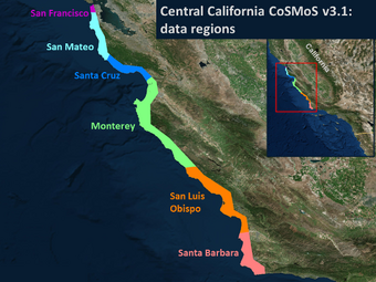
Data for central California, included in this collection:
- CoSMoS Central California v3.1 projections of coastal cliff retreat due to 21st century sea-level rise
- CoSMoS Central California v3.1 projections of shoreline change due to 21st century sea level rise
- CoSMoS v3.1 - San Francisco County
- CoSMoS v3.1 - San Luis Obispo County
- CoSMoS v3.1 - San Mateo County
- CoSMoS v3.1 - Santa Barbara County
Barnard, P.L., Erikson, L.H., Foxgrover, A.C., Limber, P.L., O'Neill, A.C., and Vitousek, S., 2018, Coastal Storm Modeling System (CoSMoS) for Central California, v3.1 (ver. 1e, October 2019): U.S. Geological Survey data release, https://doi.org/10.5066/P9NUO62B.
Below are other science projects associated with this project.

Coastal Storm Modeling System (CoSMoS)

PS-CoSMoS: Puget Sound Coastal Storm Modeling System

CoSMoS 3.1: Central California

CoSMoS 2.2: Pt. Arena and Russian River

CoSMoS 3.0: Southern California

CoSMoS 2.1: San Francisco Bay

CoSMoS 2.0: North-central California (outer coast)

Operational CoSMoS model: San Francisco Bay

CoSMoS 1.0: Southern California
CoSMoS v3.1 for central California shows projections for future climate scenarios (sea-level rise and storms)
The Coastal Storm Modeling System (CoSMoS) makes detailed predictions (meter-scale) over large geographic scales (100s of kilometers) of storm-induced coastal flooding and erosion for both current and future sea-level rise (SLR) scenarios. CoSMoS version 3.1 for central California shows projections for future climate scenarios (sea-level rise and storms) to provide emergency responders and coastal planners with critical storm-hazards information that can be used to increase public safety, mitigate physical damages, and more effectively manage and allocate resources within complex coastal settings.
Data for central California, included in this collection:
- CoSMoS Central California v3.1 projections of coastal cliff retreat due to 21st century sea-level rise
- CoSMoS Central California v3.1 projections of shoreline change due to 21st century sea level rise
- CoSMoS v3.1 - San Francisco County
- CoSMoS v3.1 - San Luis Obispo County
- CoSMoS v3.1 - San Mateo County
- CoSMoS v3.1 - Santa Barbara County
Barnard, P.L., Erikson, L.H., Foxgrover, A.C., Limber, P.L., O'Neill, A.C., and Vitousek, S., 2018, Coastal Storm Modeling System (CoSMoS) for Central California, v3.1 (ver. 1e, October 2019): U.S. Geological Survey data release, https://doi.org/10.5066/P9NUO62B.
Below are other science projects associated with this project.
Coastal Storm Modeling System (CoSMoS)
PS-CoSMoS: Puget Sound Coastal Storm Modeling System
CoSMoS 3.1: Central California
CoSMoS 2.2: Pt. Arena and Russian River
CoSMoS 3.0: Southern California
CoSMoS 2.1: San Francisco Bay
CoSMoS 2.0: North-central California (outer coast)
Operational CoSMoS model: San Francisco Bay