
Operational CoSMoS model: San Francisco Bay
The San Francisco Bay Coastal Flood Forecast pilot project is an operational CoSMoS model, part of a project funded by the California Department of Water Resources (CA-DWR) and NOAA’s Earth System Research Laboratory (ESRL).
In development
As part of a project funded by the California Department of Water Resources (CA-DWR) and NOAA’s Earth System Research Laboratory (ESRL), the Coastal Flood Forecast project aims to link watershed flood projections with CoSMoS’ ocean-based flood projections for operational and integrated coastal-flood forecasts up to 72 hours in advance of an approaching storm. Watershed flood projections are determined by NOAA’s National Weather Service (NWS) Office of Hydrologic Development Research Distributed Hydrologic Model (RDHM).
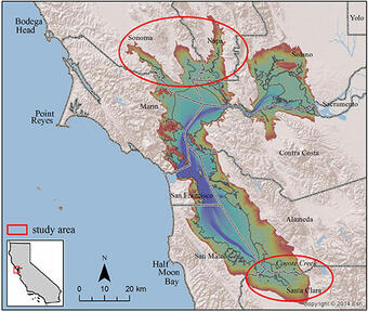
The pilot project focuses on two areas within the San Francisco Bay: the Napa and Petaluma River watersheds in North Bay, and the South Bay region in vicinity of Coyote Creek and Guadalupe River. A full Bay operational model is in the scoping phase.
Model enhancements for this operational implementation include:
- Use of a flexible-mesh model (Delft3D-FM) for increased resolution in nearshore areas and near infrastructure and flood-control features
- Use of the latest wind and pressure fields from NWS forecasts
- Operational connections to RDHM for indentSelected storm and precipitation events
- Rapid coastal flooding assessment using the Rapid Flood Spreading Method (RFSM)
Below is a link to the main project description, followed by links to all CoSMoS Applications.

Coastal Storm Modeling System (CoSMoS)

PS-CoSMoS: Puget Sound Coastal Storm Modeling System

CoSMoS 3.1: Central California

CoSMoS 2.2: Pt. Arena and Russian River

CoSMoS 3.0: Southern California

CoSMoS 2.1: San Francisco Bay

CoSMoS 2.0: North-central California (outer coast)

Operational CoSMoS model: San Francisco Bay

CoSMoS 1.0: Southern California
The San Francisco Bay Coastal Flood Forecast pilot project is an operational CoSMoS model, part of a project funded by the California Department of Water Resources (CA-DWR) and NOAA’s Earth System Research Laboratory (ESRL).
In development
As part of a project funded by the California Department of Water Resources (CA-DWR) and NOAA’s Earth System Research Laboratory (ESRL), the Coastal Flood Forecast project aims to link watershed flood projections with CoSMoS’ ocean-based flood projections for operational and integrated coastal-flood forecasts up to 72 hours in advance of an approaching storm. Watershed flood projections are determined by NOAA’s National Weather Service (NWS) Office of Hydrologic Development Research Distributed Hydrologic Model (RDHM).
The pilot project focuses on two areas within the San Francisco Bay: the Napa and Petaluma River watersheds in North Bay, and the South Bay region in vicinity of Coyote Creek and Guadalupe River. A full Bay operational model is in the scoping phase.
Model enhancements for this operational implementation include:
- Use of a flexible-mesh model (Delft3D-FM) for increased resolution in nearshore areas and near infrastructure and flood-control features
- Use of the latest wind and pressure fields from NWS forecasts
- Operational connections to RDHM for indentSelected storm and precipitation events
- Rapid coastal flooding assessment using the Rapid Flood Spreading Method (RFSM)
Below is a link to the main project description, followed by links to all CoSMoS Applications.
Coastal Storm Modeling System (CoSMoS)
PS-CoSMoS: Puget Sound Coastal Storm Modeling System
CoSMoS 3.1: Central California
CoSMoS 2.2: Pt. Arena and Russian River
CoSMoS 3.0: Southern California
CoSMoS 2.1: San Francisco Bay
CoSMoS 2.0: North-central California (outer coast)
Operational CoSMoS model: San Francisco Bay