
Here you will find general information on the science behind tsunami generation, computer animations of tsunamis, and summaries of past field studies.
Field Studies

Our researchers collect data from sites of recent tsunamis to gain a better understanding of the potential impact on other regions with high probability of tsunamis. Their work helps inform coastal planning, protection, and resiliency.
Animations
Learn about the earthquakes that triggered recent tsunami events, and watch computer simulations of each tsunami from different angles.
Learn More
Background information and links to our other tsunami research projects.
The scope of tsunami research within the USGS, however, is broader than the topics covered here. USGS researchers have also provided critical research toward understanding how sediments are transported during tsunami runup and deciphering the geologic record of prehistoric tsunamis. The USGS collaborates closely with the NOAA Center for Tsunami Research.
As part of the National Tsunami Hazard Mitigation Program, the USGS has also upgraded the seismograph network and communication functions of the U.S. Tsunami Warning Center.
Soon after the devastating tsunami in the Indian Ocean on December 26, 2004 many people have asked, “Could such a tsunami happen in the United States?” As a starting point, read “Could It Happen Here?”
Starting points:
- Could It Happen Here?
- Life of a Tsunami
- Local Tsunamis in the Pacific Northwest
-
- Not all tsunamis are generated by earthquakes
- Tsunamis can be caused by volcanoes, landslides, and even atmospheric disturbances
- Data from tide gauges can help unravel the complex physics of these sources
Tsunami events:
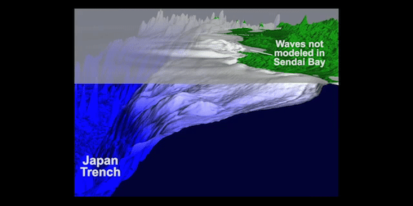
March 11, 2011, Japan
- Preliminary simulations of the tsunami
- Notes from the field: International Tsunami Team visits Japan before (2010) and after (May 2011);
plus eyewitness accounts from California on March 11
September 29, 2009, Samoa
- Preliminary analysis of the tsunami
- USGS scientists in Samoa and American Samoa studying impacts of tsunami
April 1, 2007, Solomon Islands
March 28, 2005, Sumatra
- Analysis and comparison of the December 2004 and March 2005 tsunamis
- Field study of the effects of the December 2004 and March 2005 earthquakes and tsunamis - April 2005
December 26, 2004, Sumatra-Andaman Islands
- Tsunami generation from the 2004 M=9.1 Sumatra-Andaman earthquake
- Initial findings on tsunami sand deposits, damage, and inundation in Sumatra - January 2005
- Initial findings on tsunami sand deposits, damage, and inundation in Sri Lanka - January 2005
June 23, 2001, Peru
- Preliminary analysis of the tsunami generated by the earthquake
- Preliminary analysis of sedimentary deposits from the tsunami
July 17, 1998, Papua New Guinea

PubTalk 1/2017 — Unusual sources of tsunamis
A presentation on "Unusual Sources of Tsunamis From Krakatoa to Monterey Bay" by Eric Geist, USGS Research Geophysicist - Not all tsunamis are generated by earthquakes.- Tsunamis can be caused by volcanoes, landslides, and even atmospheric disturbances- Data from tide gauges can help unravel the complex physics of these sources Videographers: Mitch Adelson, William Seelig, USGS
Here you will find general information on the science behind tsunami generation, computer animations of tsunamis, and summaries of past field studies.
Field Studies
Our researchers collect data from sites of recent tsunamis to gain a better understanding of the potential impact on other regions with high probability of tsunamis. Their work helps inform coastal planning, protection, and resiliency.
Animations
Learn about the earthquakes that triggered recent tsunami events, and watch computer simulations of each tsunami from different angles.
Learn More
Background information and links to our other tsunami research projects.
The scope of tsunami research within the USGS, however, is broader than the topics covered here. USGS researchers have also provided critical research toward understanding how sediments are transported during tsunami runup and deciphering the geologic record of prehistoric tsunamis. The USGS collaborates closely with the NOAA Center for Tsunami Research.
As part of the National Tsunami Hazard Mitigation Program, the USGS has also upgraded the seismograph network and communication functions of the U.S. Tsunami Warning Center.
Soon after the devastating tsunami in the Indian Ocean on December 26, 2004 many people have asked, “Could such a tsunami happen in the United States?” As a starting point, read “Could It Happen Here?”
Starting points:
- Could It Happen Here?
- Life of a Tsunami
- Local Tsunamis in the Pacific Northwest
-
- Not all tsunamis are generated by earthquakes
- Tsunamis can be caused by volcanoes, landslides, and even atmospheric disturbances
- Data from tide gauges can help unravel the complex physics of these sources
Tsunami events:
March 11, 2011, Japan
- Preliminary simulations of the tsunami
- Notes from the field: International Tsunami Team visits Japan before (2010) and after (May 2011);
plus eyewitness accounts from California on March 11
September 29, 2009, Samoa
- Preliminary analysis of the tsunami
- USGS scientists in Samoa and American Samoa studying impacts of tsunami
April 1, 2007, Solomon Islands
March 28, 2005, Sumatra
- Analysis and comparison of the December 2004 and March 2005 tsunamis
- Field study of the effects of the December 2004 and March 2005 earthquakes and tsunamis - April 2005
December 26, 2004, Sumatra-Andaman Islands
- Tsunami generation from the 2004 M=9.1 Sumatra-Andaman earthquake
- Initial findings on tsunami sand deposits, damage, and inundation in Sumatra - January 2005
- Initial findings on tsunami sand deposits, damage, and inundation in Sri Lanka - January 2005
June 23, 2001, Peru
- Preliminary analysis of the tsunami generated by the earthquake
- Preliminary analysis of sedimentary deposits from the tsunami
July 17, 1998, Papua New Guinea
PubTalk 1/2017 — Unusual sources of tsunamis
A presentation on "Unusual Sources of Tsunamis From Krakatoa to Monterey Bay" by Eric Geist, USGS Research Geophysicist - Not all tsunamis are generated by earthquakes.- Tsunamis can be caused by volcanoes, landslides, and even atmospheric disturbances- Data from tide gauges can help unravel the complex physics of these sources Videographers: Mitch Adelson, William Seelig, USGS