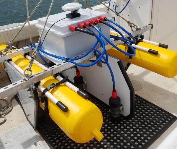
U.S. flag

An official website of the United States government

Images

St. Petersburg Coastal and Marine Science Center images.

Filter Total Items: 708
A bronze bust and stained-glass artwork of Tampa Bay in a window dedicated to Congressman Bill Young in 2002
Bust and stained-glass art dedicated to C.W. Bill Young

Bust and stained-glass art dedicated to C.W. Bill Young in 2002. This dedication stands in the Breezeway between the Studebaker and Getting buildings at the USGS St. Petersburg Coastal and Marine Science Center.

Bust and stained-glass art dedicated to C.W. Bill Young in 2002. This dedication stands in the Breezeway between the Studebaker and Getting buildings at the USGS St. Petersburg Coastal and Marine Science Center.

Cliff feature outputs from the algorithm are shown as colored dots and lines on a 3-dimensional rendering of a coastal cliff.
Cliff Feature Delineation Tool Outputs in Malibu, California

Digital three-dimensional rendering of the coastal cliffs around Point Dume in Malibu, California. Cliff feature outputs from the Cliff Feature Delineation Tool are shown to conceptually display the cliff delineation process, including cross-shore transects (green), the cliff top line (red), the cliff toe line (blue), and subsidiary cliff features (orange).

Digital three-dimensional rendering of the coastal cliffs around Point Dume in Malibu, California. Cliff feature outputs from the Cliff Feature Delineation Tool are shown to conceptually display the cliff delineation process, including cross-shore transects (green), the cliff top line (red), the cliff toe line (blue), and subsidiary cliff features (orange).

A coral reef in the Turks and Caicos Islands dominated by the weedy coral species, Porites astreoides
Modern coral reef dominated by weedy coral species

A coral reef in the Turks and Caicos Islands dominated by the weedy coral species, Porites astreoides. The relative dominance of this taxa has increased throughout the western Atlantic.

A coral reef in the Turks and Caicos Islands dominated by the weedy coral species, Porites astreoides. The relative dominance of this taxa has increased throughout the western Atlantic.

Diagram of a series of tubes connected to a well head, with an inset showing the structure inside the tubes
Above ground mesocosm with biofilm growth reactors

Above ground mesocosm with biofilm growth reactors. Groundwater from the well head is directly transferred to the mesocosm via PTFE tubing into a high flow rate control valve (a) that diverts groundwater into a flow cell containing a water quality measurement meter (b) and a low flow control valve (c).

Above ground mesocosm with biofilm growth reactors. Groundwater from the well head is directly transferred to the mesocosm via PTFE tubing into a high flow rate control valve (a) that diverts groundwater into a flow cell containing a water quality measurement meter (b) and a low flow control valve (c).

Collage of images showing the area of study with underwater photographs of the seafloor and dots on the map to show photo locations.
squid-5StudyAreaMap.jpg

Image map of study area showing (a) study region, (b) study sites, (c, d) example orthomosaic images, and (e) photo of SET 1.

A photo of a National Park Service information plate showing a great white shark at Cape Cod, MA.
A photo of a National Park Service information plate

A photo of a National Park Service information plate on “Sharks in Cape Cod Waters”, Cape Cod, MA, taken during a field study reconnaissance mission.  

Scientific equipment on the deck of a ship in the ocean
On board the IODP vessel JOIDES Resolution

Several instruments visible on board the research vessel JOIDES Resolution. Photo taken from the ship bridge roof. USGS logo visible on one of the pieces of equipment. Research cruises taken on the JOIDES Resolution are often interdisciplinary and collaborative across many universities, scientific agencies, and other research institutions.

Several instruments visible on board the research vessel JOIDES Resolution. Photo taken from the ship bridge roof. USGS logo visible on one of the pieces of equipment. Research cruises taken on the JOIDES Resolution are often interdisciplinary and collaborative across many universities, scientific agencies, and other research institutions.

A man and a woman holding a coral sample
USGS and National Park Service partner on coral growth study

Glenn Simpson (left), Park Manager of the Dry Tortugas National Park, National Park Service and Ilsa Kuffner (right), USGS Research Marine Biologist, with an elkhorn coral from Pulaski Shoal being weighed and measured.

Glenn Simpson (left), Park Manager of the Dry Tortugas National Park, National Park Service and Ilsa Kuffner (right), USGS Research Marine Biologist, with an elkhorn coral from Pulaski Shoal being weighed and measured.

A man kneels in a grassy marsh shoreline with a boat in the water behind him.
Measuring tidal inundation in a marsh shoreline
Photo looking down on 3 scientists kneeling in the marsh to retrieve their sediments tiles
Point aux Chênes, Mississippi marsh tile collection

Sediment tiles, used for short-term sedimentation rates, are collected in November 2019 from Point aux Chênes, Mississippi marsh following a 3-month deployment; the sediment accumulated on the tile will be measured and analyzed for diatoms and sediment properties.

Sediment tiles, used for short-term sedimentation rates, are collected in November 2019 from Point aux Chênes, Mississippi marsh following a 3-month deployment; the sediment accumulated on the tile will be measured and analyzed for diatoms and sediment properties.

Sand that overwashed a coastal road is piled high on both sides of a road after preliminary clearing.
Overwashed sand, piled high on both sides of the road after the storm

Mounds of sand cleared from the roadway stand high on both sides of a road near the beach in Pensacola Beach, Florida, in October 2004 after Hurricane Ivan.

A man stands beside a garage with a damaged door that is more than halfway filled with sand
A garage in Alabama filled with sand after Hurricane Ivan in 2004

U.S. Geological Survey (USGS) researcher Dave Thompson stands next to a garage in Gulf Shores, Alabama, that filled with sand after Hurricane Ivan in 2004.

Elkhorn coral on a cinderblock with a label on a coral reef
Elkhorn coral at a calcification assessment station at Crocker Reef

Established in 2009, the U.S. Geological Survey’s Coral Assessment Network (USGS-CAN) provides data on coral-growth (calcification) rates throughout the Florida Keys. Pictured here is a coral at Crocker Reef in the upper Florida Keys.

Established in 2009, the U.S. Geological Survey’s Coral Assessment Network (USGS-CAN) provides data on coral-growth (calcification) rates throughout the Florida Keys. Pictured here is a coral at Crocker Reef in the upper Florida Keys.

Corals on a USGS calcification-assessment station in Buck Island Reef National Monument, St. Croix, U.S. Virgin Islands
Corals on a USGS calcification assessment station in Buck Island Reef National Monument

Established in 2009, the U.S. Geological Survey’s Coral Assessment Network (USGS-CAN) provides data on coral-growth (calcification) rates throughout the Florida Keys and St. Croix, U.S. Virgin Islands. Pictured here is one of 30 stations located in Buck Island Reef National Monument.

Established in 2009, the U.S. Geological Survey’s Coral Assessment Network (USGS-CAN) provides data on coral-growth (calcification) rates throughout the Florida Keys and St. Croix, U.S. Virgin Islands. Pictured here is one of 30 stations located in Buck Island Reef National Monument.

Two scientists use a cylinder to collect mud in a grassy marsh
USGS geologists study sediment exchange in estuary and marshes

Sediments in estuarine and marsh environments contain organic peat, or material derived from life, that plays an important role in ecosystem health. Here, USGS geologist Chris Smith of the St.

a photograph of multiple long steel poles on the beach going into the water with a pier in the background and a bright blue sky
Cross Shore Array Deployment at the FRF

The USGS Coastal and Estuarine Dynamics Group will be deploying a cross shore array at Pea Island, various intruments will be connected to the poles to measure oceanographic conditions

Was this page helpful?