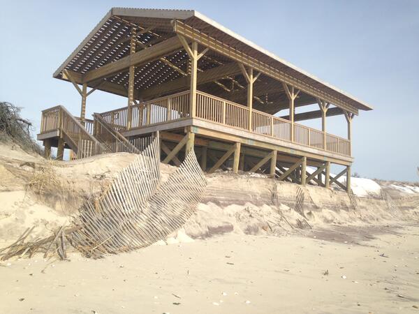
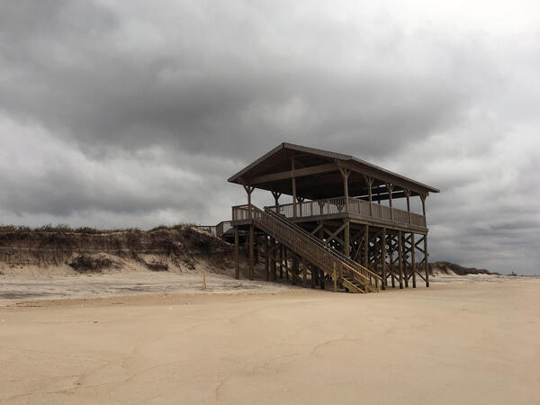
U.S. flag

An official website of the United States government

Images

St. Petersburg Coastal and Marine Science Center images.

Filter Total Items: 708
two women stand near a poster under a tent talking to the public
Discussing corals as climate change recorders at an outreach event

USGS scientists Lauren Toth and Jen Flannery of the St. Petersburg Coastal and Marine Science Center discuss how they study corals to better understand past climate change. The Center participates in the St. Petersburg Science Festival each year. 

Two men and two women stand together smiling for the photo near a wall with a fancy lamp on it.
Presenters at a USGS-sponsored session at SACNAS

The Society for Advancement of Chicanos/Hispanics and Native Americans in Science (SACNAS) held a conference in Long Beach, California, from October 13–15, 2016. Presenters at the conference in the USGS-sponsored session titled, “Clocks in the Rocks, Coral, and Wood: Dating Techniques That Keep Ti

The Society for Advancement of Chicanos/Hispanics and Native Americans in Science (SACNAS) held a conference in Long Beach, California, from October 13–15, 2016. Presenters at the conference in the USGS-sponsored session titled, “Clocks in the Rocks, Coral, and Wood: Dating Techniques That Keep Ti

Six ladies stand together, smiling, along a railing with buildings in back of them.
USGS attendees at 6th International Symposium of Deep Sea Corals

Six USGS scientists presented their research at the 6th International Symposium on Deep-Sea Corals in September, 2016. This all-female force hailed from USGS centers in West Virginia, California, and Florida. Left to right: Jill Bourque, Cheryl Morrison, Nancy Prouty, Katharine Coykendall, Amanda Demopoulos, Christina Kellogg.

Six USGS scientists presented their research at the 6th International Symposium on Deep-Sea Corals in September, 2016. This all-female force hailed from USGS centers in West Virginia, California, and Florida. Left to right: Jill Bourque, Cheryl Morrison, Nancy Prouty, Katharine Coykendall, Amanda Demopoulos, Christina Kellogg.

28 people 6 with name labels stand on wooden bridge in bright sunlight. Behind, a beach and grassy bluff stretch into distance
Participants in September 2016 Argus Workshop, Duck, North Carolina

Participants at the September 2016 Argus Workshop at the U.S. Army Corps of Engineers Field Research Facility in Duck, North Carolina. Labels provide names of four participants from USGS Coastal and Marine Geology Program (Long, Plant, Brown, Harrison) and two participants from Oregon State University (Holman, Stanley).

Participants at the September 2016 Argus Workshop at the U.S. Army Corps of Engineers Field Research Facility in Duck, North Carolina. Labels provide names of four participants from USGS Coastal and Marine Geology Program (Long, Plant, Brown, Harrison) and two participants from Oregon State University (Holman, Stanley).

Aerial photograph of Breton Island, Sept. 7, 2016

Aerial photograph of Breton Island, Sept. 7, 2016. The USGS Coastal and Marine Hazards and Resources Program studies changes to coastal landscapes such as barrier islands.

Aerial photograph of Breton Island, Sept. 7, 2016. The USGS Coastal and Marine Hazards and Resources Program studies changes to coastal landscapes such as barrier islands.

A 14-cm upland peat auger sediment core of a brown peat above fine tan silty sand
Upland peat auger sediment core collected in the field at Grand Bay

A 14-cm upland peat auger sediment core of a brown peat above fine tan silty sand was collected from the Grand Bay National Estuarine Research Reserve in May, 2016.

a black, spiny sea urchin among some yellow coral and mangrove prop roots
Diadema antillarum, the long-spined sea urchin

Diadema antillarum, the long-spined sea urchin, is an ecologically important species in Caribbean coral reef habitats where it controls algal growth and coverage and helps keep reef surfaces clear for corals to grow and settle. In early 2022, the remaining D. antillarum populations began experiencing mass mortality in the Caribbean.

Diadema antillarum, the long-spined sea urchin, is an ecologically important species in Caribbean coral reef habitats where it controls algal growth and coverage and helps keep reef surfaces clear for corals to grow and settle. In early 2022, the remaining D. antillarum populations began experiencing mass mortality in the Caribbean.

Seven men and women stand together, in front of flags on a stage, smiling for the camera and holding awards.
Winners of the USGS 2016 Shoemaker Award for Communication Excellence

In May 2016, Susan Russell-Robinson (Associate Coordinator of the USGS Coastal and Marine Geology Program, third from right) and Dave Applegate (USGS Associate Director for Natural Hazards, left) celebrated with the team whose website “USGS Coastal and Marine Geology Program (CMGP, now called CMHRP

In May 2016, Susan Russell-Robinson (Associate Coordinator of the USGS Coastal and Marine Geology Program, third from right) and Dave Applegate (USGS Associate Director for Natural Hazards, left) celebrated with the team whose website “USGS Coastal and Marine Geology Program (CMGP, now called CMHRP

A 21-cm marsh peat auger sediment core containing a brown peat above a gray clayey silt sediment layer
Marsh peat auger sediment core containing peat above a gray clayey silt

A 21-cm marsh peat auger sediment core containing a brown peat above a clayey silty gray sediment layer was collected in the field in the Grand Bay National Estuarine Research Reserve in May, 2016.

a group of black long-spined sea urchins on a rocky sea floor encrusted with some colorful corals
Group of Diadema antillarum, the long-spined sea urchin

Diadema antillarum, the long-spined sea urchin, is an ecologically important species in Caribbean coral reef habitats where it controls algal growth and coverage and helps keep reef surfaces clear for corals to grow and settle. In early 2022, the remaining D. antillarum populations began experiencing mass mortality in the Caribbean.

Diadema antillarum, the long-spined sea urchin, is an ecologically important species in Caribbean coral reef habitats where it controls algal growth and coverage and helps keep reef surfaces clear for corals to grow and settle. In early 2022, the remaining D. antillarum populations began experiencing mass mortality in the Caribbean.

A scientist stands on a dune with scientific equipment with the ocean in the background.
Ground-Penetrating Radar acquisition at Fire Island, NY

Ground-Penetrating Radar instruments are towed across land. Data from this instrument show underlying sediment layers within the dune and barrier island, which may reveal patterns of growth and erosion.

Ground-Penetrating Radar instruments are towed across land. Data from this instrument show underlying sediment layers within the dune and barrier island, which may reveal patterns of growth and erosion.

A colony of the soft coral known as the "bent sea rod" stands bleached on a reef off of Islamorada, Florida.
Bent Sea Rod Bleaching

A colony of the soft coral known as the "bent sea rod" stands bleached on a reef off of Islamorada, Florida. Hard and soft corals are presently bleaching- losing their symbiotic algae – all over the coral reefs of the Florida Keys due to unusually warm ocean temperatures this summer.

A colony of the soft coral known as the "bent sea rod" stands bleached on a reef off of Islamorada, Florida. Hard and soft corals are presently bleaching- losing their symbiotic algae – all over the coral reefs of the Florida Keys due to unusually warm ocean temperatures this summer.

A red fox trots across the beach on Fire Island

A red fox trots across the beach on Fire Island with dunes and waves in the background

Scientists on a beach use sediment coring equipment (a tall aluminum barrel and motor to vibrate the barrel into the ground)
Collecting a sediment vibracore on the beach in Fire Island, NY

We collect terrestrial (barrier island) and marine (nearshore and estuarine) sediment cores to ground-truth geophysical observations. These cores are used to understand the history of barrier island formation and erosion.

Was this page helpful?