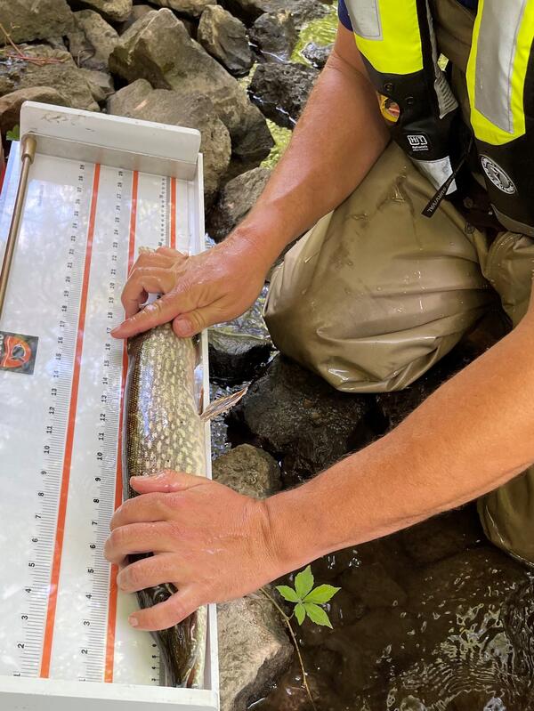
Measuring fish length at Jewel Creek at Muskego, Wisconsin
Measuring fish length at Jewel Creek at Muskego, WisconsinFish are weighed and measured for length.

Official websites use .gov
A .gov website belongs to an official government organization in the United States.
Secure .gov websites use HTTPS
A lock () or https:// means you’ve safely connected to the .gov website. Share sensitive information only on official, secure websites.
Upper Midwest Water Science Center images.
Fish are weighed and measured for length.
Fish are weighed and measured for length.

Looking upstream Underwood Creek Tributary near Oak Leaf Trail at West Allis, Wisconsin, during summer. https://waterdata.usgs.gov/monitoring-location/0408708573/
Looking upstream Underwood Creek Tributary near Oak Leaf Trail at West Allis, Wisconsin, during summer. https://waterdata.usgs.gov/monitoring-location/0408708573/

Stream gage at Little Menomonee River, upstream of the confluence with the Menomonee River, Wisconsin. https://waterdata.usgs.gov/monitoring-location/04087070/
Stream gage at Little Menomonee River, upstream of the confluence with the Menomonee River, Wisconsin. https://waterdata.usgs.gov/monitoring-location/04087070/
USGS scientists collecting phytoplankton for mercury and per- and polyfluoroalkyl substances (PFAS) analyses in Saginaw Bay of Lake Huron.
USGS scientists collecting phytoplankton for mercury and per- and polyfluoroalkyl substances (PFAS) analyses in Saginaw Bay of Lake Huron.

MI-BaRL (Lansing, MI) microbiologist JC Wallace (foreground) and biologist Molly Richard (background) prepare samples for analysis to determine bacteria load and the concentration of E. coli and enterococci.
MI-BaRL (Lansing, MI) microbiologist JC Wallace (foreground) and biologist Molly Richard (background) prepare samples for analysis to determine bacteria load and the concentration of E. coli and enterococci.

Michigan Bacteriological Research Laboratory (MI-BaRL) biologist Alexei Rose filters stream water samples for cultivation on selective media for bacteria growth.
Michigan Bacteriological Research Laboratory (MI-BaRL) biologist Alexei Rose filters stream water samples for cultivation on selective media for bacteria growth.

Michigan Bacterological Research Laboratory (MI-BaRL) microbiologist JC Wallace (foreground) and biologist Molly Richard (background) prepare samples for analysis to determine bacteria load and the concentration of E. coli and enterococci.
Michigan Bacterological Research Laboratory (MI-BaRL) microbiologist JC Wallace (foreground) and biologist Molly Richard (background) prepare samples for analysis to determine bacteria load and the concentration of E. coli and enterococci.

View of the Menomonee River near 70th Street in Wauwatosa, Wisconsin in summer.
View of the Menomonee River near 70th Street in Wauwatosa, Wisconsin in summer.

Menomonee River and streamgage house (in foreground) near 70th Street in Wauwatosa, Wisconsin. https://waterdata.usgs.gov/monitoring-location/04087120/
Menomonee River and streamgage house (in foreground) near 70th Street in Wauwatosa, Wisconsin. https://waterdata.usgs.gov/monitoring-location/04087120/

View of downtown Milwaukee, Wisconsin, taken from the Discovery World museum during a summer morning.
View of downtown Milwaukee, Wisconsin, taken from the Discovery World museum during a summer morning.

A restored section of the Kinnickinnic River near 6th Street in Milwaukee, Wisconsin in summer.
A restored section of the Kinnickinnic River near 6th Street in Milwaukee, Wisconsin in summer.

USGS meeting with National Weather Service at Gladstone, Michigan office garage, July 14, 2022. (From left to right: Matt Chilson, Doug Bonno, Dean Burdett, Evan Kutta, Jim Salzwedel, Jordan Wendt, Greg Sova, Chris Hoard, Matt Holmio, Ralph Haefner).
USGS meeting with National Weather Service at Gladstone, Michigan office garage, July 14, 2022. (From left to right: Matt Chilson, Doug Bonno, Dean Burdett, Evan Kutta, Jim Salzwedel, Jordan Wendt, Greg Sova, Chris Hoard, Matt Holmio, Ralph Haefner).
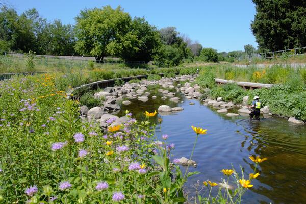
Habitat sampling at a restored reach at Underwood Creek at Wauwatosa, Wisconsin. https://waterdata.usgs.gov/monitoring-location/04087088/
Habitat sampling at a restored reach at Underwood Creek at Wauwatosa, Wisconsin. https://waterdata.usgs.gov/monitoring-location/04087088/

Swans take flight from a grassy island in the middle of Horicon National Wildlife Refuge on a summer day.
Swans take flight from a grassy island in the middle of Horicon National Wildlife Refuge on a summer day.

Water sampling equipment in a raft at Horicon National Wildlife Refuge, Wisconsin.
Water sampling equipment in a raft at Horicon National Wildlife Refuge, Wisconsin.
USGS scientists prepare to sample for environmental AIV at an impoundment at Horicon National Wildlife Refuge, Wisconsin
USGS scientists prepare to sample for environmental AIV at an impoundment at Horicon National Wildlife Refuge, Wisconsin

Hydrologic Technician Dean Burdett prepares to board a floatplane with water samples taken from streamgage 04040000 Washington Creek near Windigo, MI, Isle Royale National Park, May 24, 2022. https://waterdata.usgs.gov/monitoring-location/04001000/
Hydrologic Technician Dean Burdett prepares to board a floatplane with water samples taken from streamgage 04040000 Washington Creek near Windigo, MI, Isle Royale National Park, May 24, 2022. https://waterdata.usgs.gov/monitoring-location/04001000/

Photograph of research hydrologist Victoria G. Christensen, Upper Midwest Water Science Center
Photograph of research hydrologist Victoria G. Christensen, Upper Midwest Water Science Center

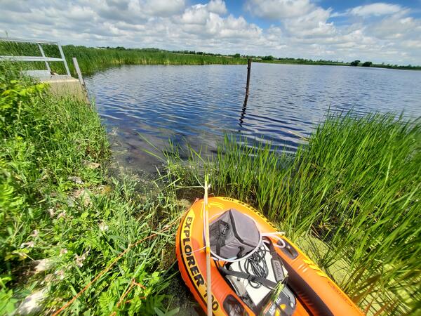
An orange inflatable raft containing water sampling equipment sits on the shore of a recreational lake at Rapp Park and Recreation Area, Iowa.
An orange inflatable raft containing water sampling equipment sits on the shore of a recreational lake at Rapp Park and Recreation Area, Iowa.

The R/V Arcticus docked at the UW-Milwaukee School of Freshwater Sciences on its journey from home base in Cheboygan, Michigan to Ludington, Michigan.
The R/V Arcticus docked at the UW-Milwaukee School of Freshwater Sciences on its journey from home base in Cheboygan, Michigan to Ludington, Michigan.

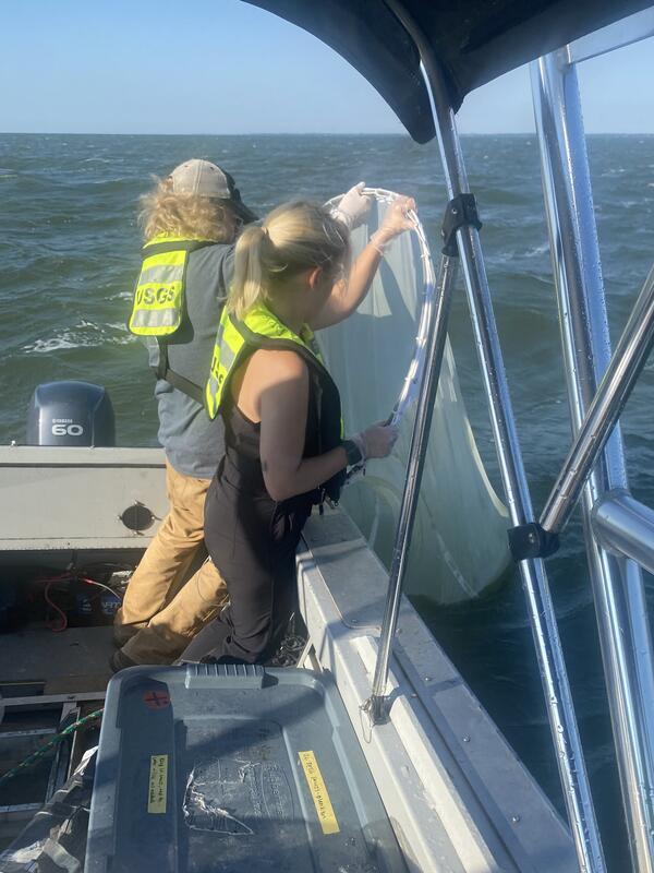
Grace Armstrong collecting water samples while riding in a boat, sampling in Wisconsin.
Grace Armstrong collecting water samples while riding in a boat, sampling in Wisconsin.