U.S. flag

An official website of the United States government

Images

Upper Midwest Water Science Center images.

Filter Total Items: 581
Scientist posing next to truck with bed filled with large sample water bottles
Erin Stelzer arriving to MI-BaRL lab with truck carrying over 1100 liters of wetland water prepped for avian influenza study

Erin Stelzer collected and transported over 1100 liters of wetland water to the Michigan Bacteriological Research Laboratory (MI-BaRL; Lansing, MI) as part of work to finalize laboratory methods to detect infectious avian influenza virus (AIV) in freshwater. The methods will test how biotic factors and water chemistry influenced the recovery of a known con

Erin Stelzer collected and transported over 1100 liters of wetland water to the Michigan Bacteriological Research Laboratory (MI-BaRL; Lansing, MI) as part of work to finalize laboratory methods to detect infectious avian influenza virus (AIV) in freshwater. The methods will test how biotic factors and water chemistry influenced the recovery of a known con

Large geophysical survey hoop on snowy ground, technician walking past
Airborne electromagnetic (AEM) survey hoop on snowy ground with technician walking by for scale

Geophysical equipment loop for airborne electromagnetic (AEM) survey on ground prior to liftoff. Technician on ground for scale. In March 2022, a helicopter carried an airborne electromagnetic induction sensor over parts of southeast and southwest Wisconsin as part of a USGS study to map the aquifers in the region.

Geophysical equipment loop for airborne electromagnetic (AEM) survey on ground prior to liftoff. Technician on ground for scale. In March 2022, a helicopter carried an airborne electromagnetic induction sensor over parts of southeast and southwest Wisconsin as part of a USGS study to map the aquifers in the region.

Person viewed from behind, talking to a group of people facing towards camera, snowy ground and everyone wearing winter gear
Burke Minsley speaking to group of USGS employees and Cooperators at AEM survey in southwest Wisconsin 2022

Research geophysicist Burke Minsley discussing aerial electromagnetic (AEM) survey equipment with group of USGS employees and Cooperators at AEM survey in southwest Wisconsin 2022. In March 2022, a helicopter carried an airborne electromagnetic induction sensor over parts of southeast and southwest Wisconsin as part of a USGS study to map the aquifers in t

Research geophysicist Burke Minsley discussing aerial electromagnetic (AEM) survey equipment with group of USGS employees and Cooperators at AEM survey in southwest Wisconsin 2022. In March 2022, a helicopter carried an airborne electromagnetic induction sensor over parts of southeast and southwest Wisconsin as part of a USGS study to map the aquifers in t

Large geophysical survey hoop on snowy ground, technician walking past
Airborne electromagnetic (AEM) survey hoop on snowy ground with technician preparing for liftoff

Geophysical equipment loop for airborne electromagnetic (AEM) survey on ground prior to liftoff. Technician on ground for scale. In March 2022, a helicopter carried an airborne electromagnetic induction sensor over parts of southeast and southwest Wisconsin as part of a USGS study to map the aquifers in the region.

Geophysical equipment loop for airborne electromagnetic (AEM) survey on ground prior to liftoff. Technician on ground for scale. In March 2022, a helicopter carried an airborne electromagnetic induction sensor over parts of southeast and southwest Wisconsin as part of a USGS study to map the aquifers in the region.

Man standing near large hoop on ground pointing and talking, two people standing listening, in foreground hands holding paper
Burke Minsley speaking to group of USGS employees and SkyTEM employees about AEM survey

Research geophysicist Burke Minsley discussing aerial electromagnetic (AEM) survey equipment with group of USGS employees and Cooperators at AEM survey in southwest Wisconsin 2022. In March 2022, a helicopter carried an airborne electromagnetic induction sensor over parts of southeast and southwest Wisconsin as part of a USGS study to map the aquifers in t

Research geophysicist Burke Minsley discussing aerial electromagnetic (AEM) survey equipment with group of USGS employees and Cooperators at AEM survey in southwest Wisconsin 2022. In March 2022, a helicopter carried an airborne electromagnetic induction sensor over parts of southeast and southwest Wisconsin as part of a USGS study to map the aquifers in t

Group of people in snowy field, one person in middle talking, large hoop on ground
Group of USGS employees and Cooperators gathered at AEM survey in southwest Wisconsin 2022

Research geophysicist Burke Minsley discussing aerial electromagnetic (AEM) survey equipment with group of USGS employees and Cooperators at AEM survey in southwest Wisconsin 2022. In March 2022, a helicopter carried an airborne electromagnetic induction sensor over parts of southeast and southwest Wisconsin as part of a USGS study to map the aquifers in t

Research geophysicist Burke Minsley discussing aerial electromagnetic (AEM) survey equipment with group of USGS employees and Cooperators at AEM survey in southwest Wisconsin 2022. In March 2022, a helicopter carried an airborne electromagnetic induction sensor over parts of southeast and southwest Wisconsin as part of a USGS study to map the aquifers in t

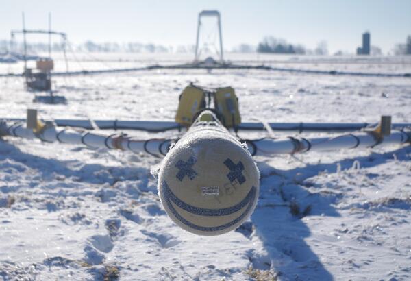
Smiley face made of black tape on front of large geophysical survey hoop
Smiley face on front of AEM survey equipment southern Wisconsin 2022

Smiley face on front of electromagnetic (AEM) survey equipment at AEM survey in southwest Wisconsin 2022. In March 2022, a helicopter carried an airborne electromagnetic induction sensor over parts of southeast and southwest Wisconsin as part of a USGS study to map the aquifers in the region.

Smiley face on front of electromagnetic (AEM) survey equipment at AEM survey in southwest Wisconsin 2022. In March 2022, a helicopter carried an airborne electromagnetic induction sensor over parts of southeast and southwest Wisconsin as part of a USGS study to map the aquifers in the region.

Group of people watching and taking photos of helicopter towing large hoop, everyone wearing winter gear and snowy ground
USGS employees and Cooperators watching AEM survey helicopter towing hoop liftoff

USGS employees and cooperators watching and photographing helicopter lifting off with geophysical equipment loop below attached via slingload. In March 2022, a helicopter carried an airborne electromagnetic induction sensor over parts of southeast and southwest Wisconsin as part of a USGS study to map the aquifers in the region.

USGS employees and cooperators watching and photographing helicopter lifting off with geophysical equipment loop below attached via slingload. In March 2022, a helicopter carried an airborne electromagnetic induction sensor over parts of southeast and southwest Wisconsin as part of a USGS study to map the aquifers in the region.

Group of people in snowy field, one person in middle talking, large hoop on ground
Sun shining over group of USGS employees and Cooperators at AEM survey in southwest Wisconsin 2022

Research geophysicist Burke Minsley discussing aerial electromagnetic (AEM) survey equipment with group of USGS employees and Cooperators at AEM survey in southwest Wisconsin 2022. In March 2022, a helicopter carried an airborne electromagnetic induction sensor over parts of southeast and southwest Wisconsin as part of a USGS study to map the aquifers in t

Research geophysicist Burke Minsley discussing aerial electromagnetic (AEM) survey equipment with group of USGS employees and Cooperators at AEM survey in southwest Wisconsin 2022. In March 2022, a helicopter carried an airborne electromagnetic induction sensor over parts of southeast and southwest Wisconsin as part of a USGS study to map the aquifers in t

Helicopter parked on ground with snowy ground
Helicopter for AEM survey southern Wisconsin 2022

Helicopter used to tow electromagnetic (AEM) survey equipment at AEM survey in southwest Wisconsin 2022. In March 2022, a helicopter carried an airborne electromagnetic induction sensor over parts of southeast and southwest Wisconsin as part of a USGS study to map the aquifers in the region.

Helicopter used to tow electromagnetic (AEM) survey equipment at AEM survey in southwest Wisconsin 2022. In March 2022, a helicopter carried an airborne electromagnetic induction sensor over parts of southeast and southwest Wisconsin as part of a USGS study to map the aquifers in the region.

Equipment on back of hoop with SKYTEM and logo on it
Sensor on back of geophysical equipment hoop for AEM survey southern Wisconsin 2022

Geophysical equipment loop with sensor from SKYTEM for electromagnetic (AEM) survey in southwest Wisconsin 2022. In March 2022, a helicopter carried an airborne electromagnetic induction sensor over parts of southeast and southwest Wisconsin as part of a USGS study to map the aquifers in the region.

Geophysical equipment loop with sensor from SKYTEM for electromagnetic (AEM) survey in southwest Wisconsin 2022. In March 2022, a helicopter carried an airborne electromagnetic induction sensor over parts of southeast and southwest Wisconsin as part of a USGS study to map the aquifers in the region.

Helicopter towing large hoop over snow covered ground, technician for scale
Helicopter towing hoop for airborne electromagnetic (AEM) survey 2022

Photo of helicopter with geophysical equipment loop deployed below it via slingload. Technician on ground for scale. In March 2022, a helicopter carried an airborne electromagnetic induction sensor over parts of southeast and southwest Wisconsin as part of a USGS study to map the aquifers in the region.

Photo of helicopter with geophysical equipment loop deployed below it via slingload. Technician on ground for scale. In March 2022, a helicopter carried an airborne electromagnetic induction sensor over parts of southeast and southwest Wisconsin as part of a USGS study to map the aquifers in the region.

Helicopter with large hoop hanging below, technician on snowy ground for scale
Helicopter starting liftoff towing hoop for airborne electromagnetic (AEM) survey 2022

Helicopter lifting off with geophysical equipment loop on ground below attached via slingload. Technician on ground for scale. In March 2022, a helicopter carried an airborne electromagnetic induction sensor over parts of southeast and southwest Wisconsin as part of a USGS study to map the aquifers in the region.

Helicopter lifting off with geophysical equipment loop on ground below attached via slingload. Technician on ground for scale. In March 2022, a helicopter carried an airborne electromagnetic induction sensor over parts of southeast and southwest Wisconsin as part of a USGS study to map the aquifers in the region.

Helicopter with large hoop hanging below, technician on snowy ground for scale
Helicopter liftoff towing hoop for airborne electromagnetic (AEM) survey 2022

Helicopter lifting off with geophysical equipment loop below attached via slingload. Technician on ground for scale. In March 2022, a helicopter carried an airborne electromagnetic induction sensor over parts of southeast and southwest Wisconsin as part of a USGS study to map the aquifers in the region.

Helicopter lifting off with geophysical equipment loop below attached via slingload. Technician on ground for scale. In March 2022, a helicopter carried an airborne electromagnetic induction sensor over parts of southeast and southwest Wisconsin as part of a USGS study to map the aquifers in the region.

Group of people in snowy field, one person in middle talking, large hoop on ground
Burke Minsley explaining AEM technology to group of USGS employees and Cooperators at AEM survey in southwest Wisconsin 2022

Research geophysicist Burke Minsley discussing aerial electromagnetic (AEM) survey equipment with group of USGS employees and Cooperators at AEM survey in southwest Wisconsin 2022. In March 2022, a helicopter carried an airborne electromagnetic induction sensor over parts of southeast and southwest Wisconsin as part of a USGS study to map the aquifers in t

Research geophysicist Burke Minsley discussing aerial electromagnetic (AEM) survey equipment with group of USGS employees and Cooperators at AEM survey in southwest Wisconsin 2022. In March 2022, a helicopter carried an airborne electromagnetic induction sensor over parts of southeast and southwest Wisconsin as part of a USGS study to map the aquifers in t

Group of people in snowy field, one person in middle talking and pointing away from camera, large hoop on ground
Burke Minsley pointing to equipment while speaking to group of USGS employees and Cooperators at AEM survey in southwest Wisconsin 2022

Research geophysicist Burke Minsley discussing aerial electromagnetic (AEM) survey equipment with group of USGS employees and Cooperators at AEM survey in southwest Wisconsin 2022. In March 2022, a helicopter carried an airborne electromagnetic induction sensor over parts of southeast and southwest Wisconsin as part of a USGS study to map the aquifers in t

Colored pencil illustration of hikers in the grand canyon
Where to Go Next
Where to Go Next
Where to Go Next

This is a loosely drawn illustration of two hikers on the trail. It was drawn for the final page of a fact sheet and intended for text overlay. The text primarily indicates avenues of further study and next steps of the project.

This is a loosely drawn illustration of two hikers on the trail. It was drawn for the final page of a fact sheet and intended for text overlay. The text primarily indicates avenues of further study and next steps of the project.

Colored pencil illustration of an elk with a forest background
Elk
Elk
Elk

Part of a series of small inset drawings, this is quite simply, an Elk. The backdrop is that of pinyon pine and Red Butte.

Part of a series of small inset drawings, this is quite simply, an Elk. The backdrop is that of pinyon pine and Red Butte.

Colored pencil illustration of a truck traveling a haul road from a mine site.
The Long Haul
The Long Haul
The Long Haul

This is a small inset drawing of a truck traveling a haul road from a mine site.  It is a southwestern landscape, and depicts dust kicked from the road and becoming airborne over the surrounding vegetation and landscape.

This is a small inset drawing of a truck traveling a haul road from a mine site.  It is a southwestern landscape, and depicts dust kicked from the road and becoming airborne over the surrounding vegetation and landscape.

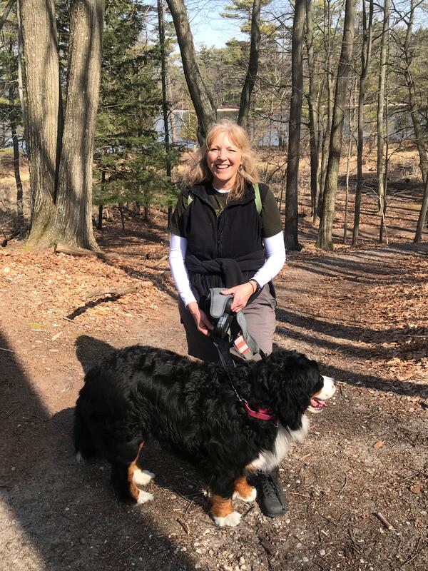
Smiling woman standing with Bernese Mountain Dog on wooded hiking trail
Faith Fitzpatrick hiking with her Bernese Mountain Dog

Faith Fitzpatrick taking her Bernese Mountain dog on a hike to check out rock outcrops around southern Wisconsin.

Was this page helpful?