
The bottom portion of the Coastal Change Hazards Portal product summary page within the Coastal Science Navigator. The Coastal Science Navigator serves as a gateway to USGS Coastal Change Hazards resources and assists users in finding products and tools that will meet their specific needs.
Images
Woods Hole Coastal and Marine Science Center images
Filter Total Items: 1119

Coastal Science Navigator - CCH Portal
The bottom portion of the Coastal Change Hazards Portal product summary page within the Coastal Science Navigator. The Coastal Science Navigator serves as a gateway to USGS Coastal Change Hazards resources and assists users in finding products and tools that will meet their specific needs.

Coastal Science Navigator - Filter Search
The Filter Search page within the Coastal Science Navigator. The Coastal Science Navigator serves as a gateway to USGS Coastal Change Hazards resources and assists users in finding products and tools that will meet their specific needs. The Filter Search allows users to see all available products and apply filters to narrow the adjacent list to relevant to
The Filter Search page within the Coastal Science Navigator. The Coastal Science Navigator serves as a gateway to USGS Coastal Change Hazards resources and assists users in finding products and tools that will meet their specific needs. The Filter Search allows users to see all available products and apply filters to narrow the adjacent list to relevant to

Coastal Science Navigator - Guided Search
The Guided Search page within the Coastal Science Navigator. The Coastal Science Navigator serves as a gateway to USGS Coastal Change Hazards resources and assists users in finding products and tools that will meet their specific needs.
The Guided Search page within the Coastal Science Navigator. The Coastal Science Navigator serves as a gateway to USGS Coastal Change Hazards resources and assists users in finding products and tools that will meet their specific needs.

USGS Coastal Science Navigator
The USGS Coastal Science Navigator serves as a gateway to USGS Coastal Change Hazards resources and assists users in finding products and tools that will meet their specific needs.
The USGS Coastal Science Navigator serves as a gateway to USGS Coastal Change Hazards resources and assists users in finding products and tools that will meet their specific needs.

Surface elevation table measurements on a degraded marsh in Jamaica Bay, New York
Jim Lynch (NPS) measuring marsh elevation change using a Surface Elevation Table (SET) near West Pond, Jamaica Bay, New York. Lateral erosion can reduce overall marsh area while elevation of the marsh at a point may be keeping pace with sea-level rise.
Jim Lynch (NPS) measuring marsh elevation change using a Surface Elevation Table (SET) near West Pond, Jamaica Bay, New York. Lateral erosion can reduce overall marsh area while elevation of the marsh at a point may be keeping pace with sea-level rise.

Conducting multichannel seismic operations at the main lab of the Research Vessel Marcus G. Langseth
linkMain lab of the Research Vessel Marcus G. Langseth (Columbia University - Lamont-Doherty Earth Observatory) while underway conducting multichannel seismic operations.
Spring 2023 Photo Contest Winner: Wayne Baldwin, Honorable Mention category

Coastal Change Likelihood Geonarrative
The Coastal Change Likelihood (CCL) assessment combines over twenty coastal data sources that describe the landscape and the hazards that act on it to determine the future likelihood of change on the coast in the next decade.
The Coastal Change Likelihood (CCL) assessment combines over twenty coastal data sources that describe the landscape and the hazards that act on it to determine the future likelihood of change on the coast in the next decade.

USGS at Coastal Sediments 2023
The USGS was proud to be an exhibitor and sponsor at the Coastal Sediments Conference in New Orleans, Louisiana, in April 2023.
The USGS was proud to be an exhibitor and sponsor at the Coastal Sediments Conference in New Orleans, Louisiana, in April 2023.

Herring River Restoration Project Groundbreaking Event
Meagan Eagle, Research Physical Scientist with the U.S. Geological Survey, Woods Hole Coastal and Marine Science Center, talking about USGS contributions to the Herring River Restoration Project with Congressman Bill Keating at the groundbreaking event.
Meagan Eagle, Research Physical Scientist with the U.S. Geological Survey, Woods Hole Coastal and Marine Science Center, talking about USGS contributions to the Herring River Restoration Project with Congressman Bill Keating at the groundbreaking event.

Herring River Restoration Project Groundbreaking Event
Kevin Kroeger, Research Chemist with the U.S. Geological Survey, Woods Hole Coastal and Marine Science Center, talking about blue carbon research with Congressman Bill Keating at the Herring River Restoration Project groundbreaking event.
Kevin Kroeger, Research Chemist with the U.S. Geological Survey, Woods Hole Coastal and Marine Science Center, talking about blue carbon research with Congressman Bill Keating at the Herring River Restoration Project groundbreaking event.

Herring River Restoration Project Groundbreaking Event
Kevin Kroeger, Marcel Belaval, and Rob Thieler of the U.S. Geological Survey talking with other collaborators involved in the Herring River Restoration Project.
Kevin Kroeger, Marcel Belaval, and Rob Thieler of the U.S. Geological Survey talking with other collaborators involved in the Herring River Restoration Project.

Herring River Restoration Project Groundbreaking Event
Marcel Belaval (Deputy Director, USGS New England Water Science Center), Rob Thieler (Center Director, USGS Woods Hole Coastal and Marine Science Center), Brian Carlstrom (Superintendent, Cape Cod National Seashore, U.S.
Marcel Belaval (Deputy Director, USGS New England Water Science Center), Rob Thieler (Center Director, USGS Woods Hole Coastal and Marine Science Center), Brian Carlstrom (Superintendent, Cape Cod National Seashore, U.S.

Herring River Restoration Project Groundbreaking Event
The USGS celebrating the groundbreaking of the Herring River restoration!
The USGS celebrating the groundbreaking of the Herring River restoration!

Herring River Restoration Project
A sign at the Herring River Restoration Project Groundbreaking Event detailing restoration plans.
A sign at the Herring River Restoration Project Groundbreaking Event detailing restoration plans.

Herring River Restoration Project Groundbreaking Event
State and Federal officials joined partners involved in the Herring River Restoration Project for a group photo at the groundbreaking event at Chequessett Neck bridge in Wellfleet, Massachusetts.
State and Federal officials joined partners involved in the Herring River Restoration Project for a group photo at the groundbreaking event at Chequessett Neck bridge in Wellfleet, Massachusetts.
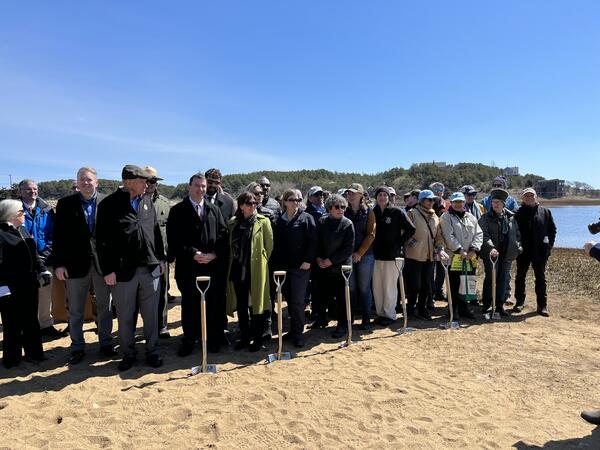

Herring River Restoration Project Groundbreaking Event
The USGS celebrating the groundbreaking of the Herring River restoration!
The USGS celebrating the groundbreaking of the Herring River restoration!

Herring River Restoration Project Groundbreaking Event
Rob Thieler, Meagan Eagle, and Sophie Kuhl of the U.S. Geological Survey, Woods Hole Coastal and Marine Science Center posing with the “Salt Marshes: A Carbon Bank in Our Backyard” sign near the Herring River.
Rob Thieler, Meagan Eagle, and Sophie Kuhl of the U.S. Geological Survey, Woods Hole Coastal and Marine Science Center posing with the “Salt Marshes: A Carbon Bank in Our Backyard” sign near the Herring River.