
Coastal Landscape Response to Sea-Level Rise Assessment for the Northeastern United States
The Coastal Landscape Response to Sea-Level Rise Assessment creates multidecadal predictions of where and when the coast is likely to adapt or inundate. Results are produced for four decades—the 2030s, 2050s, 2080s, and 2100s. This information helps users determine where land will be available in its current or changed form or become submerged in response to future sea level change. Providing information on where coastal land will likely be available—or not—for future use helps land use managers and decision makers from federal and state agencies make long-term plans concerning important infrastructure and valuable resources.
Structured Decision Making

The Sea-Level Rise Hazards and Decision-Support project is developing decision-support models and tools through collaboration with researchers, resource managers and decision makers from federal and state agencies and non-governmental organizations.
Probabilistic Framework

This project seeks to provide a geospatially explicit description of coastal landscape change and land loss in response to SLR by evaluating the likelihood of inundation as well as dynamic coastal change in different settings.
Predicted Outcomes

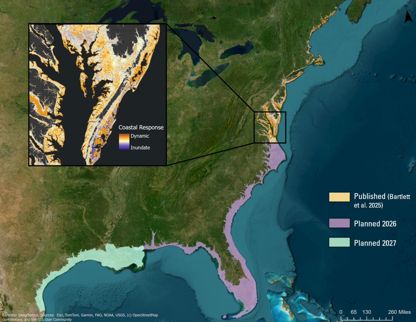
These GIS layers provide coastal response likelihoods and forecasts of the adjusted land elevation with respect to sea-level rise scenarios for the Northeastern U.S. for the 2030s, 2050s, 2080s and 2100s.
The effects of sea-level change (SLC) and coastal storm intensities will continue to have a broad range of impacts on natural and built environments. These effects include changes in habitat area and/or quality along sandy and/or wetland shorelines, and increased vulnerability of human infrastructure.
The approach uses a statistical framework to provide a geospatially explicit assessment of where coastal landscapes and land loss is may to occur response to sea-level change. The probabilistic outcomes generated evaluate both the likelihood of inundation and dynamic coastal processes across a range of settings, and inherently account for uncertainty, making results robust and straightforward to integrate into decision-making.
The work was originally developed to address decision-support needs identified through a collaborative Structured Decision Making (SDM) process involving regional resource managers and researchers associated with the North Atlantic Landscape Conservation Cooperative (NALCC). Initial outputs covered the Northeastern U.S. coast from Maine to Virginia.
In 2024, the U.S. Department of War (DoW) supported updates to the Northeast assessment, including higher-resolution land cover data and new sea-level rise scenarios. As of 2025, DoW support has enabled geographic expansion of the Coastal Landscape Response Assessment to the U.S. Atlantic and Gulf coasts. These assessments are critical for understanding future changes that may affect military installations, sites, missions, and infrastructure throughout these regions.
Products that forecast coastal change likelihood are critical to support informed and proactive planning ensuring national security. By understanding where and when change is expected, decision makers help ensure lives and critical infrastructure are safe and secure, and taxpayer dollars are not wasted on preventable damages and lost revenue.
Download: Coastal Response Likelihood code
Below are other science projects associated with this project.

Sea-Level Rise Hazards and Decision Support

Coastal Landscape- Structured Decision Making

Coastal Landscape- Change Predictions
Below are news stories associated with this project.

Up to 70 Percent of Northeast U.S. Coast May Adapt to Rising Seas Up to 70 Percent of Northeast U.S. Coast May Adapt to Rising Seas
The Coastal Landscape Response to Sea-Level Rise Assessment creates multidecadal predictions of where and when the coast is likely to adapt or inundate. Results are produced for four decades—the 2030s, 2050s, 2080s, and 2100s. This information helps users determine where land will be available in its current or changed form or become submerged in response to future sea level change. Providing information on where coastal land will likely be available—or not—for future use helps land use managers and decision makers from federal and state agencies make long-term plans concerning important infrastructure and valuable resources.
Structured Decision Making
The Sea-Level Rise Hazards and Decision-Support project is developing decision-support models and tools through collaboration with researchers, resource managers and decision makers from federal and state agencies and non-governmental organizations.
Probabilistic Framework
This project seeks to provide a geospatially explicit description of coastal landscape change and land loss in response to SLR by evaluating the likelihood of inundation as well as dynamic coastal change in different settings.
Predicted Outcomes
These GIS layers provide coastal response likelihoods and forecasts of the adjusted land elevation with respect to sea-level rise scenarios for the Northeastern U.S. for the 2030s, 2050s, 2080s and 2100s.
The effects of sea-level change (SLC) and coastal storm intensities will continue to have a broad range of impacts on natural and built environments. These effects include changes in habitat area and/or quality along sandy and/or wetland shorelines, and increased vulnerability of human infrastructure.
The approach uses a statistical framework to provide a geospatially explicit assessment of where coastal landscapes and land loss is may to occur response to sea-level change. The probabilistic outcomes generated evaluate both the likelihood of inundation and dynamic coastal processes across a range of settings, and inherently account for uncertainty, making results robust and straightforward to integrate into decision-making.
The work was originally developed to address decision-support needs identified through a collaborative Structured Decision Making (SDM) process involving regional resource managers and researchers associated with the North Atlantic Landscape Conservation Cooperative (NALCC). Initial outputs covered the Northeastern U.S. coast from Maine to Virginia.
In 2024, the U.S. Department of War (DoW) supported updates to the Northeast assessment, including higher-resolution land cover data and new sea-level rise scenarios. As of 2025, DoW support has enabled geographic expansion of the Coastal Landscape Response Assessment to the U.S. Atlantic and Gulf coasts. These assessments are critical for understanding future changes that may affect military installations, sites, missions, and infrastructure throughout these regions.
Products that forecast coastal change likelihood are critical to support informed and proactive planning ensuring national security. By understanding where and when change is expected, decision makers help ensure lives and critical infrastructure are safe and secure, and taxpayer dollars are not wasted on preventable damages and lost revenue.
Download: Coastal Response Likelihood code
Below are other science projects associated with this project.
Sea-Level Rise Hazards and Decision Support
Coastal Landscape- Structured Decision Making
Coastal Landscape- Change Predictions
Below are news stories associated with this project.