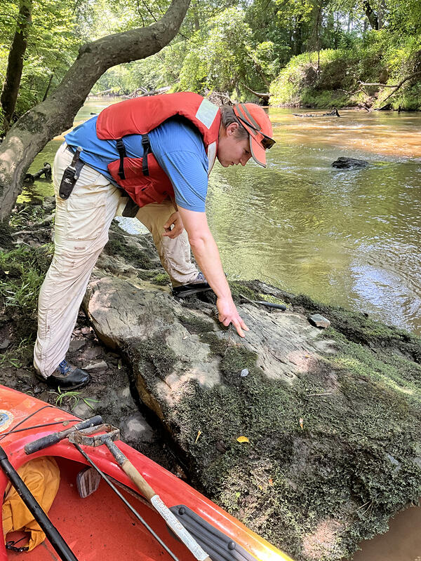
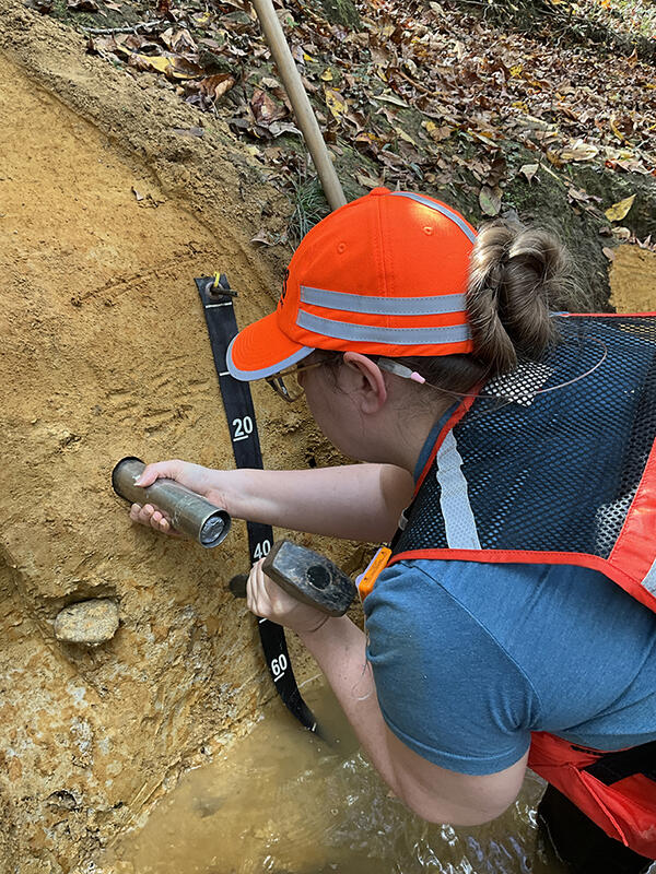
NATIONAL LANDSLIDE SUSCEPTIBILITY MAP
Images
Images
POSTFIRE DEBRIS FLOW SCIENCE
The U.S. Geological Survey helps local, state, and federal agencies assess debris flow hazards in recently burned areas. We provide information about the likelihood of debris flow activity, where they might happen, and how big they might be.
DEBRIS FLOW ASSESSMENTS
POSTFIRE DEBRIS FLOW SCIENCE
The U.S. Geological Survey helps local, state, and federal agencies assess debris flow hazards in recently burned areas. We provide information about the likelihood of debris flow activity, where they might happen, and how big they might be.
DEBRIS FLOW ASSESSMENTS
LANDSLIDE SAFETY
If your home or property was damaged by a landslide from Hurricane Helene, be aware of the warning signs of future landslide activity
WATCH FOR WARNING SIGNS
Signs a landslide may be moving include:
LANDSLIDE SAFETY
If your home or property was damaged by a landslide from Hurricane Helene, be aware of the warning signs of future landslide activity
WATCH FOR WARNING SIGNS
Signs a landslide may be moving include:
An aircraft glides low, towing instruments to collect data on groundwater and geology.
An aircraft glides low, towing instruments to collect data on groundwater and geology.An aircraft glides low, towing instruments to collect data on groundwater and geology.
An aircraft glides low, towing instruments to collect data on groundwater and geology.
An aircraft glides low, towing instruments to collect data on groundwater and geology.An aircraft glides low, towing instruments to collect data on groundwater and geology.
Geology in Bond Swamp National Wildlife Refuge in Georgia
Geology in Bond Swamp National Wildlife Refuge in GeorgiaAn outcrop of Cretaceous sand and gravel on the Bond Swamp National Wildlife Refuge in Georgia. USGS geologists are analyzing these sediments for their critical mineral potential. Photo by Mark Carter, USGS.
Collecting geologic samples on Fountain Creek in Emporia, Virginia
Collecting geologic samples on Fountain Creek in Emporia, VirginiaDiana Carriker, USGS Florence Bascom Geoscience Center Pollen Lab manager, collects a sample of river alluvium for Optically Stimulated Luminescence dating on Fountain Creek in Emporia, Virginia. Photo by Mark Carter, USGS.
Geology work on Fishing Creek in Roanoke Rapids, NC
Geology work on Fishing Creek in Roanoke Rapids, NCArthur Merschat, a USGS research geologist, prepares to collect a rock sample for geochemical and geochronologic analysis on Fishing Creek in the Roanoke Rapids, North Carolina. Photo by Mark Carter, USGS.
A large rock outcrop in Piedmont National Wildlife Refuge in Georgia
A large rock outcrop in Piedmont National Wildlife Refuge in GeorgiaA large rock outcrop on Piedmont National Wildlife Refuge in Georgia. USGS geologists are mapping these rocks to better understand the geology along the fall zone in central Georgia for critical minerals and earthquake hazards. Photo by Mark Carter, USGS.
Topobathymetric digital elevation model of the Santiam River in the Willamette Valley southeast of Salem, Oregon.
Topobathymetric digital elevation model of the Santiam River in the Willamette Valley southeast of Salem, Oregon.Topobathymetric digital elevation model of the Santiam River in the Willamette Valley southeast of Salem, Oregon.
Great Salt Lake Commissioner Logo for media advisory. Great Salt Lake Commissioner Logo for media advisory.
Topobathymetric digital elevation model of the Santiam River in the Willamette Valley southeast of Salem, Oregon.
Topobathymetric digital elevation model of the Santiam River in the Willamette Valley southeast of Salem, Oregon.Topobathymetric digital elevation model of the Santiam River in the Willamette Valley southeast of Salem, Oregon.
Santiam 3D Topobathymetric digital elevation model
Santiam 3D Topobathymetric digital elevation modelTopobathymetric digital elevation model of the Santiam River in the Willamette Valley southeast of Salem, Oregon. The trees and dry land are shown as a lidar point cloud colored based on aerial imagery.
Probability for PFAS in groundwater at the depth of public drinking water supply
Probability for PFAS in groundwater at the depth of public drinking water supplyUSGS national estimates of the probability for PFAS in groundwater at the depth of public drinking water supply. Read the associated USGS study at https://doi.org/10.1126/science.ado6638.
Probability for PFAS in groundwater at the depth of private drinking water supply
Probability for PFAS in groundwater at the depth of private drinking water supplyUSGS national estimates of the probability for PFAS in groundwater at the depth of private drinking water supply. Read the associated USGS study at https://doi.org/10.1126/science.ado6638.
The Pacific sand lance is an important forage fish found in Puget Sound. They employ a unique strategy of burrowing into sand to rest and conserve energy, and to avoid predation. The USGS is currently studying forage fish spawning, and how human development may be affecting their habitat.
SPOOKY SCIENCE (and having some fun with a playful, silly, not real science career)
Coloring page for geoscience careers. This page highlights those who want to become a geodesist.
Coloring page for geoscience careers. This page highlights those who want to become a geographer.
Coloring page for geoscience careers. This page highlights those who want to become a hydrologist.
Coloring page for geoscience careers. This page highlights those who want to become a volcanologist.