
As part of a USGS radiotelemetry study, this tegu carried a transmitter backpack for a year to provide information on how tegus are moving through Florida landscapes
Images
Images
Filter Total Items: 9447

Radiotelemetered Tegu
As part of a USGS radiotelemetry study, this tegu carried a transmitter backpack for a year to provide information on how tegus are moving through Florida landscapes

Cableway Over Souris River near Sherwood
USGS Personnel using a cableway and accoustic doppler current profiler to measure streamflow on the Souris River near Sherwood, North Dakota.
USGS Personnel using a cableway and accoustic doppler current profiler to measure streamflow on the Souris River near Sherwood, North Dakota.

Pallid Sturgeon Eggs on an Artificial Substrate
Eggs collected from pallid sturgeon spawned in hatcheries are placed onto an artificial rock substrate. Pallid sturgeon eggs are extremely sticky after fertilization and adhere to the artificial substrate, even in a current.
Eggs collected from pallid sturgeon spawned in hatcheries are placed onto an artificial rock substrate. Pallid sturgeon eggs are extremely sticky after fertilization and adhere to the artificial substrate, even in a current.

Water Quality Sampling at Mount Rushmore National Memorial
Water Quality Sampling at Mount Rushmore National MemorialInstalling stream monitoring equipment on a tributary to Grizzly Bear Creek, May 9, 2012. Water-quality sampling of groundwater and surface water was conducted during 2011-15 at Mount Rushmore National Memorial to characterize the occurrent of perchlorate and selected metals commonly associated with fireworks.

WRP Sabine Parish, Louisiana
Wetlands Reserve Program site in Sabine Parish, Louisiana. Landowner restored his often-flooded cattle pasture to its natural wetland state by creating shallow water areas, establishing food plots and pollinator plots, and installing wood duck nesting boxes.
Wetlands Reserve Program site in Sabine Parish, Louisiana. Landowner restored his often-flooded cattle pasture to its natural wetland state by creating shallow water areas, establishing food plots and pollinator plots, and installing wood duck nesting boxes.

Diver with a Massive Starlet coral, Dry Tortugas National Park
Diver with a Massive Starlet coral, Dry Tortugas National ParkA USGS diver beside a Massive Starlet (Siderastrea siderea) coral colony in Dry Tortugas National Park. Scientists used a core from this coral to reconstruct ocean temperatures going back to 1837. Photo: USGS, May 2012

Traditional Construction in Burma
Traditional construction throughout Burma utilizes bamboo and other lightweight building materials, resulting in structures that are not generally durable but are quite earthquake-safe. As traditional structures such as this house give way to more modern masonry buildings, seismic risk will increase.
Traditional construction throughout Burma utilizes bamboo and other lightweight building materials, resulting in structures that are not generally durable but are quite earthquake-safe. As traditional structures such as this house give way to more modern masonry buildings, seismic risk will increase.

Biologists Remove Python from Everglades
This 16 1/2-foot python, being removed from the wild by USGS and NPS personnel, was captured in a thicket in Everglades National Park in May 2012.
This 16 1/2-foot python, being removed from the wild by USGS and NPS personnel, was captured in a thicket in Everglades National Park in May 2012.

Pagoda in Burma
The historic record documents many instances of damage to pagodas throughout Burma's cities and the countryside. These ancient and beautiful structures bear witness to a significant level of seismic hazard.
The historic record documents many instances of damage to pagodas throughout Burma's cities and the countryside. These ancient and beautiful structures bear witness to a significant level of seismic hazard.

Massive Starlet coral at Dry Tortugas National Park
Massive Starlet coral at Dry Tortugas National ParkScientists used a core from this Massive Starlet (Siderastrea siderea) coral colony in Dry Tortugas National Park to reconstruct ocean temperatures going back to 1837. Photo: USGS
Massive Starlet coral at Dry Tortugas National Park
Massive Starlet coral at Dry Tortugas National ParkScientists used a core from this Massive Starlet (Siderastrea siderea) coral colony in Dry Tortugas National Park to reconstruct ocean temperatures going back to 1837. Photo: USGS

New Construction in Burma
Burma's most populous city, Rangoon, is underlain by a thick blanket of soft sediments that will significantly amplify earthquake shaking. With a period of economic expansion on the horizon, new construction such as these buildings in the capital city will be potentially vulnerable to earthquake damage unless appropriate seismic provisions are adopted in the bu
Burma's most populous city, Rangoon, is underlain by a thick blanket of soft sediments that will significantly amplify earthquake shaking. With a period of economic expansion on the horizon, new construction such as these buildings in the capital city will be potentially vulnerable to earthquake damage unless appropriate seismic provisions are adopted in the bu

Schwedagon Pagoda in Burma
The Schwedagon pagoda, Burma's most revered shrine, has been damaged multiple times by earthquakes throughout its long history.
The Schwedagon pagoda, Burma's most revered shrine, has been damaged multiple times by earthquakes throughout its long history.

Sampling for Acipenseriformes
Researcher lowers an ichthyoplankton sampling net into the Missouri River.
Researcher lowers an ichthyoplankton sampling net into the Missouri River.

Female Grizzly Bear with Cub
A female grizzly with a cub. Adult females are considered the most important segment of the Greater Yellowstone grizzly population and consequently are a major focus of USGS research and monitoring.
A female grizzly with a cub. Adult females are considered the most important segment of the Greater Yellowstone grizzly population and consequently are a major focus of USGS research and monitoring.

Turbid Coastal Plume of the Elwha River, Washington
Turbid Coastal Plume of the Elwha River, WashingtonThe turbid waters of the Elwha River and the coastal waters of the Strait of Juan de Fuca mix directly offshore of the river mouth, forming a large coastal plume. This plume is easily identified by the cloudiness of the water (or "turbidity") resulting from sediment discharged by the river. Two large dams on the Elwha River are being incrementally r

Turbid Coastal Plume of the Elwha River, Washington
Turbid Coastal Plume of the Elwha River, WashingtonThe turbid waters of the Elwha River and the coastal waters of the Strait of Juan de Fuca mix directly offshore of the river mouth, forming a large coastal plume. This plume is easily identified by the cloudiness of the water (or "turbidity") resulting from sediment discharged by the river. Two large dams on the Elwha River were incrementally r

Sandstone ledges, Escondido Formation, Medina County
Sandstone ledges, Escondido Formation, Medina CountySandstone ledges in the Escondido Formation located approximately 7 miles south-southeast of the community of D’Hanis in Medina County, Texas. Photograph taken April 13, 2012, by Robert R. Morris.
SIR 2013–5149
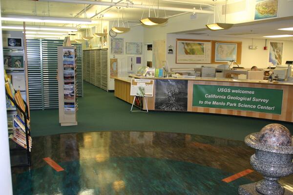
Former Map Sales Office, Menlo Park, Ca
This picture shows the USGS/California Geological Survey former location in Bldg #3, Menlo Park, Ca. This map sales office serviced the eight states in the western region, including Hawaii and Alaska. The office was relocated to the Second Floor Bldg #3, and limited to stock and sell only maps of California, and a selected special maps.
This picture shows the USGS/California Geological Survey former location in Bldg #3, Menlo Park, Ca. This map sales office serviced the eight states in the western region, including Hawaii and Alaska. The office was relocated to the Second Floor Bldg #3, and limited to stock and sell only maps of California, and a selected special maps.

Retrieving Sediment Instrumentation, Elwha River, Washington
Retrieving Sediment Instrumentation, Elwha River, WashingtonUSGS researchers Chris Curran and Raegan Huffman retrieve instrumentation to measure sediment concentration from the Elwha River, Washington. Two large dams on the Elwha River are being incrementally removed from 2011 to 2013 to restore river function in an important salmon-bearing river.

Biocrust
Photo of biocrust taken at Birds of Prey NRCA near Biose, Idaho.
Photo of biocrust taken at Birds of Prey NRCA near Biose, Idaho.

Green River near New Hradec, North Dakota
View of the Green River near New Hradec, North Dakota.
View of the Green River near New Hradec, North Dakota.