
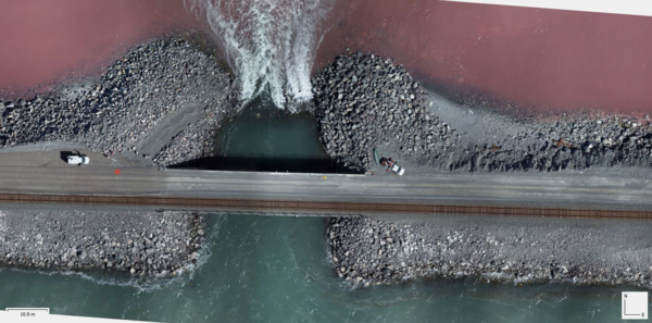
Bird's eye view of the Great Salt Lake's railroad causeway, where pink hypersaline waters of the north arm meet the blue-green waters of the south arm. The breach in the causeway allows water exchange between the two sides.
Images
Images
Filter Total Items: 9454
Great Salt Lake's railroad causeway
Bird's eye view of the Great Salt Lake's railroad causeway, where pink hypersaline waters of the north arm meet the blue-green waters of the south arm. The breach in the causeway allows water exchange between the two sides.
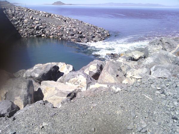
A rocky causeway divides the waters of the Great Salt Lake
A rocky causeway divides the waters of the Great Salt LakeA rocky causeway divides the waters of the Great Salt Lake, with distinct color variations visible between the north and south arms.
A rocky causeway divides the waters of the Great Salt Lake
A rocky causeway divides the waters of the Great Salt LakeA rocky causeway divides the waters of the Great Salt Lake, with distinct color variations visible between the north and south arms.

Teenage citizen-scientist helps USGS confirm unique population of threatened turtle
Teenage citizen-scientist helps USGS confirm unique population of threatened turtleAn adult female River Cooter, left, and an adult female federally-Threatened Ringed Map Turtle, right, bask in the sun near Covington, Louisiana. (Courtesy photo).

Tarah Balden, scientist, Yurok Tribe looking at data logger
Tarah Balden, scientist, Yurok Tribe looking at data loggerA soil moisture data logger buried in the ground is a specialized instrument designed to measure and record the moisture content of soil over time. Here's how it generally functions:

Flooding on Kennebec River at Calumet Bridge in Augusta, Maine
Flooding on Kennebec River at Calumet Bridge in Augusta, MaineThis USGS webcam footage shows the Kennebec River in Augusta, Maine, flooding after a large coastal storm hit much of the East Coast and battered New England with heavy rains and winds. USGS image.

Watts PA flood
Trent Watts, a USGS hydrologic technician, uses an Acoustic Doppler Current Profiler to measure the amount of water flowing in Perkiomen Creek in Graterford, Pennsylvania, on December 18. USGS photo by Cameron Ensor.
Trent Watts, a USGS hydrologic technician, uses an Acoustic Doppler Current Profiler to measure the amount of water flowing in Perkiomen Creek in Graterford, Pennsylvania, on December 18. USGS photo by Cameron Ensor.

Hallowell, Maine flood
The streets of Hallowell, Maine, were flooded following heavy rains that hit New England and most of the East Coast, December 18, 2023. USGS photo by Glenn Hodgkins
The streets of Hallowell, Maine, were flooded following heavy rains that hit New England and most of the East Coast, December 18, 2023. USGS photo by Glenn Hodgkins
USGS Wave.PNG
A cropped image of the topographic waves that can be found in the USGS visual identifier for use in thumbnails.
A cropped image of the topographic waves that can be found in the USGS visual identifier for use in thumbnails.
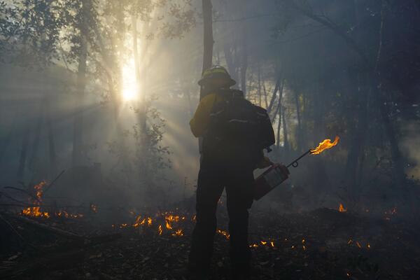
Firelighter Lighting a Fire, Fall 2023, Yurok Tribal Land
Firelighter Lighting a Fire, Fall 2023, Yurok Tribal LandThis photo shows a Firelighter, lighting a culturally prescribed fire on Yurok Land. The Yurok Tribe, native to the Pacific Northwest region of the United States, employs a unique and culturally significant method of fire management through the use of culturally prescribed burns.

Map of FY23 3D Elevation Program projects supported by Inflation Reduction Act funds.
Map of FY23 3D Elevation Program projects supported by Inflation Reduction Act funds.Map shows geographic extent of the first-ever national baseline of consistent high-resolution elevations – both bare earth and 3D point clouds. FY23 projects are the result of partnership projects awarded through the 3DEP Broad Agency Announcement (BAA) and through on-going Federal coordination via the 3DEP working group.
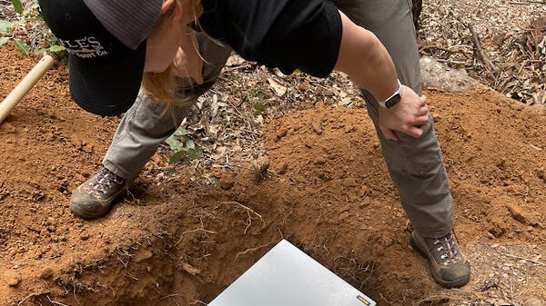
Tarah Balden, scientist, Yurok Tribe burying data logger to protect it from culturally prescribed burn.
Tarah Balden, scientist, Yurok Tribe burying data logger to protect it from culturally prescribed burn.Burying a data logger during a culturally prescribed burn is a strategic method used to protect this valuable equipment from the high temperatures and destructive potential of fire. Here's the reasoning behind this practice:
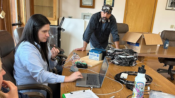
USGS and Yurok Tribe staff in Yurok Office
Staff from the USGS and Yurok Tribe working together in the Yurok Tribe Office. The Yurok Tribal Office on the Yurok Reservation is located in Klamath, California. It serves as the administrative hub for the Yurok Tribe, the largest Native American tribe in California.
Staff from the USGS and Yurok Tribe working together in the Yurok Tribe Office. The Yurok Tribal Office on the Yurok Reservation is located in Klamath, California. It serves as the administrative hub for the Yurok Tribe, the largest Native American tribe in California.
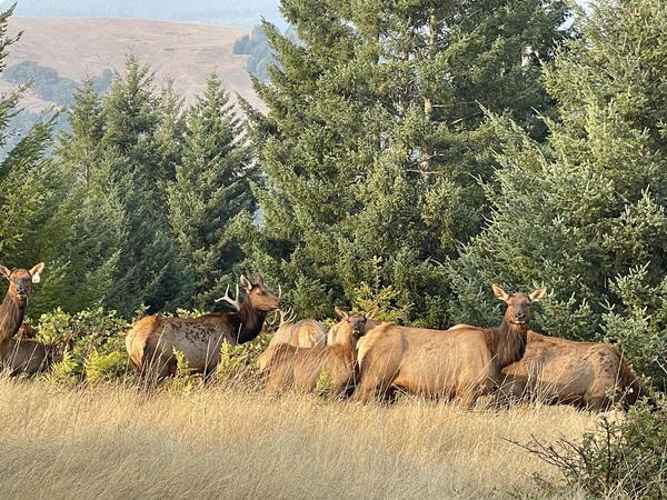
Group of Elk on Yurok Tribal Land
The Yurok prairie habitat that the Roosevelt Elk inhabit is a significant part of their traditional lands in Northern California. This habitat primarily consists of expansive, open prairies mixed with forested areas, which are typical of the region along the Pacific Coast from Northern California to British Columbia.
The Yurok prairie habitat that the Roosevelt Elk inhabit is a significant part of their traditional lands in Northern California. This habitat primarily consists of expansive, open prairies mixed with forested areas, which are typical of the region along the Pacific Coast from Northern California to British Columbia.

Sediment core from a salt marsh in Massachusetts
A sediment core extracted from a salt marsh along the Herring River at the National Park Service’s Cape Cod National Seashore in Massachusetts. USGS scientists and partners are applying the mineral olivine to the marsh to study its role in capturing carbon dioxide in tidal wetlands. Credit: Kevin Kroeger, USGS.
A sediment core extracted from a salt marsh along the Herring River at the National Park Service’s Cape Cod National Seashore in Massachusetts. USGS scientists and partners are applying the mineral olivine to the marsh to study its role in capturing carbon dioxide in tidal wetlands. Credit: Kevin Kroeger, USGS.

Salt marsh along the Herring River
A salt marsh along the Herring River at the National Park Service’s Cape Cod National Seashore in Massachusetts. USGS scientists and partners are applying the mineral olivine to the marsh to study its role in capturing carbon dioxide in tidal wetlands.
A salt marsh along the Herring River at the National Park Service’s Cape Cod National Seashore in Massachusetts. USGS scientists and partners are applying the mineral olivine to the marsh to study its role in capturing carbon dioxide in tidal wetlands.

Salt marsh along the Herring River
A salt marsh along the Herring River at the National Park Service’s Cape Cod National Seashore in Massachusetts. USGS scientists and partners are applying the mineral olivine to the marsh to study its role in capturing carbon dioxide in tidal wetlands. Credit: Kevin Kroeger, USGS.
A salt marsh along the Herring River at the National Park Service’s Cape Cod National Seashore in Massachusetts. USGS scientists and partners are applying the mineral olivine to the marsh to study its role in capturing carbon dioxide in tidal wetlands. Credit: Kevin Kroeger, USGS.

Grand Prismatic Spring
A view of the Grand Prismatic Hot Spring from the vantage point of the Grand Prismatic Overlook Trail in Yellowstone National Park, Wyoming.
A view of the Grand Prismatic Hot Spring from the vantage point of the Grand Prismatic Overlook Trail in Yellowstone National Park, Wyoming.

Yellowstone Sunset
A picturesque shot of the sun setting while driving through north Yellowstone National Park, Wyoming.
A picturesque shot of the sun setting while driving through north Yellowstone National Park, Wyoming.

Rainbow over Ledge Geyser
A rainbow rises over Ledge Geyser in Yellowstone National Park, Wyoming. "Ledge is the second largest geyser in the Norris Geyser Basin, capable of shooting water 125 feet into the air. Because it erupts at an angle, however, the water will sometimes reach the ground 220 feet away." - NPS
A rainbow rises over Ledge Geyser in Yellowstone National Park, Wyoming. "Ledge is the second largest geyser in the Norris Geyser Basin, capable of shooting water 125 feet into the air. Because it erupts at an angle, however, the water will sometimes reach the ground 220 feet away." - NPS

Castle Geyser
A view of Castle Geyser erupting as a rainbow rises out and over the eruption. Castle Geyser is located in the Upper Geyser Basin of Yellowstone National Park, Wyoming.
A view of Castle Geyser erupting as a rainbow rises out and over the eruption. Castle Geyser is located in the Upper Geyser Basin of Yellowstone National Park, Wyoming.

Bison Field
A herd of bison strolls through an open meadow close to sunset in Yellowstone National Park, Wyoming.
A herd of bison strolls through an open meadow close to sunset in Yellowstone National Park, Wyoming.