
This map shows 161 sites across Pennsylvania that were sampled for PFAS concentrations. The color coding indicates PFAS concentration levels at each site. USGS image.
Images
Images
Filter Total Items: 9454

Pennsylvania state-wide surface water PFAS study
This map shows 161 sites across Pennsylvania that were sampled for PFAS concentrations. The color coding indicates PFAS concentration levels at each site. USGS image.
Pennsylvania PFAS study illustration
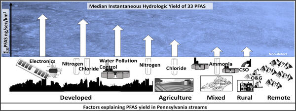
An illustration showing various PFAS sources across streams in Pennsylvania. USGS image.
An illustration showing various PFAS sources across streams in Pennsylvania. USGS image.

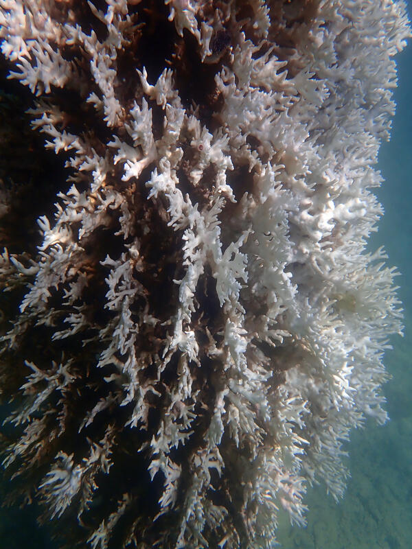
Divers putting shades over experimental Elkhorn corals in Biscayne National Park
Divers putting shades over experimental Elkhorn corals in Biscayne National ParkShown here are three SCUBA divers installing shade structures over experimental Elkhorn corals (Acropora palmata) that have become "bleached," that is, lost all their algal symbionts (also called zooxanthellae) because of the summer 2023 ocean-heat wave. The corals are attached to cement blocks as part of the U.S.

Mountain yellow-legged frogs in containers
Mountain yellow-legged frogs (Rana muscosa) in their transport containers being acclimated to their new habitat, Los Angeles County.
Mountain yellow-legged frogs (Rana muscosa) in their transport containers being acclimated to their new habitat, Los Angeles County.

Habitat of the Mountain Yellow Legged Frog
Mountain yellow-legged frog habitat found in a riparian area of Los Angeles County.
Mountain yellow-legged frog habitat found in a riparian area of Los Angeles County.

Newly released mountain yellow-legged frogs
Newly released mountain yellow-legged frogs (Rana muscosa), Los Angeles County. Mountain yellow-legged frogs were bread and captivity then released.
Newly released mountain yellow-legged frogs (Rana muscosa), Los Angeles County. Mountain yellow-legged frogs were bread and captivity then released.

Medicine Bow LLFA Survey Map
A map of the airborne geophysical survey area in the Medicine Mountains region of Wyoming
A map of the airborne geophysical survey area in the Medicine Mountains region of Wyoming

Lidar point cloud image of Cedar Key, Florida
Lidar point cloud image of Cedar Key, Florida, an area that experienced severe impacts from Hurricane Idalia in August 2023. The lowest elevations are shaded in blue, while the highest elevations (the tops of trees and buildings) range from orange to red.
Lidar point cloud image of Cedar Key, Florida, an area that experienced severe impacts from Hurricane Idalia in August 2023. The lowest elevations are shaded in blue, while the highest elevations (the tops of trees and buildings) range from orange to red.

Researchers inject fluorescein dye into Lake Fork Creek, Colorado
Researchers inject fluorescein dye into Lake Fork Creek, ColoradoResearchers inject fluorescein dye into Lake Fork Creek, Colorado, in August 2023. This study aims to trace water flow from the historic Sugarloaf mining district into the creek.

Mineral Systems Map of the United States
Maps showing parts of 23 mineral systems that could host critical mineral resources in the United States. These areas are used to prioritize data collection and analysis by Earth MRI.
Maps showing parts of 23 mineral systems that could host critical mineral resources in the United States. These areas are used to prioritize data collection and analysis by Earth MRI.

Water tracing dye injected into a stream in Leadville, Colorado.
Water tracing dye injected into a stream in Leadville, Colorado.Water tracing dye was injected into a stream in Leadville, Colorado, to identify locations of metal loading and to guide geophysical measurements.
Water tracing dye injected into a stream in Leadville, Colorado.
Water tracing dye injected into a stream in Leadville, Colorado.Water tracing dye was injected into a stream in Leadville, Colorado, to identify locations of metal loading and to guide geophysical measurements.
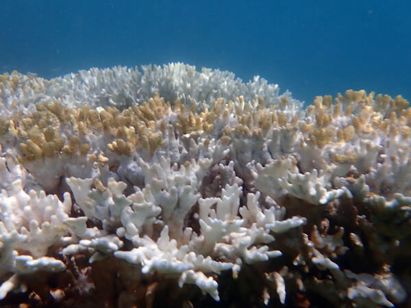
Dry Tortugas coral bleaching
A colony of fire coral about 5 feet underwater in Dry Tortugas National Park in the Gulf of Mexico shows signs of bleaching from recent extreme water temperatures. Photo taken July 26, 2023, by Lauren Toth, USGS.
A colony of fire coral about 5 feet underwater in Dry Tortugas National Park in the Gulf of Mexico shows signs of bleaching from recent extreme water temperatures. Photo taken July 26, 2023, by Lauren Toth, USGS.
Bleached Dry Tortugas Coral
Coral located in Dry Tortugas National Park in the Gulf of Mexico shows signs of bleaching. Photo taken July 26, 2023, by Lauren Toth, USGS.
Coral located in Dry Tortugas National Park in the Gulf of Mexico shows signs of bleaching. Photo taken July 26, 2023, by Lauren Toth, USGS.

Types of Landslides
TYPES OF LANDSLIDES

Creep
Creep is the imperceptibly slow, steady, downward movement of slope-forming soil or rock. Movement is caused by shear stress sufficient to produce permanent deformation, but too small to produce shear failure.
Creep is the imperceptibly slow, steady, downward movement of slope-forming soil or rock. Movement is caused by shear stress sufficient to produce permanent deformation, but too small to produce shear failure.

Debris Avalanche
Debris avalanche: This is a variety of very rapid to extremely rapid debris flow.
Debris avalanche: This is a variety of very rapid to extremely rapid debris flow.

Rockfall
Rockfalls are abrupt movements of masses of geologic materials, such as rocks and boulders, which become detached from steep slopes or cliffs. Separation occurs along discontinuities such as fractures, joints, and bedding planes, and movement occurs by free-fall, bouncing, and rolling.
Rockfalls are abrupt movements of masses of geologic materials, such as rocks and boulders, which become detached from steep slopes or cliffs. Separation occurs along discontinuities such as fractures, joints, and bedding planes, and movement occurs by free-fall, bouncing, and rolling.

Earthflow
Earthflows have a characteristic "hourglass" shape. The slope material liquefies and runs out, forming a bowl or depression at the head. The flow itself is elongated and usually occurs in fine-grained materials or clay-bearing rocks on moderate slopes and under saturated conditions. However, dry flows of granular material are also possible.
Earthflows have a characteristic "hourglass" shape. The slope material liquefies and runs out, forming a bowl or depression at the head. The flow itself is elongated and usually occurs in fine-grained materials or clay-bearing rocks on moderate slopes and under saturated conditions. However, dry flows of granular material are also possible.

Block Slide
A block slide is a translational slide in which the moving mass consists of a single unit or a few closely related units that move downslope as a relatively coherent mass.
A block slide is a translational slide in which the moving mass consists of a single unit or a few closely related units that move downslope as a relatively coherent mass.

Translational Landslide
Translational slide: In this type of slide, the landslide mass moves along a roughly planar surface with little rotation or backward tilting.
Translational slide: In this type of slide, the landslide mass moves along a roughly planar surface with little rotation or backward tilting.

Rising glacial lake in Alaska
This is a screenshot taken from a timelapse video of a rising glacial lake from May through August 2023. The video was captured by a USGS Hydrologic Imagery Visualization and Information System (HIVIS) camera. The water level in the lake gradually rises throughout the video and then the water level dramatically decreases towards the end of the video.
This is a screenshot taken from a timelapse video of a rising glacial lake from May through August 2023. The video was captured by a USGS Hydrologic Imagery Visualization and Information System (HIVIS) camera. The water level in the lake gradually rises throughout the video and then the water level dramatically decreases towards the end of the video.