
A debris flow is a form of rapid mass movement in which a combination of loose soil, rock, organic matter, air, and water mobilizes as a slurry that flows downslope. Debris flows include <50% fines.
Images
Images
Filter Total Items: 9454

Debris Flow
A debris flow is a form of rapid mass movement in which a combination of loose soil, rock, organic matter, air, and water mobilizes as a slurry that flows downslope. Debris flows include <50% fines.

Lateral Spread
Lateral spreads are distinctive because they usually occur on very gentle slopes or flat terrain. The dominant mode of movement is lateral extension accompanied by shear or tensile fractures.
Lateral spreads are distinctive because they usually occur on very gentle slopes or flat terrain. The dominant mode of movement is lateral extension accompanied by shear or tensile fractures.

Topple
Toppling failures are distinguished by the forward rotation of a unit or units about some pivotal point, below or low in the unit, under the actions of gravity and forces exerted by adjacent units or by fluids in cracks.
Toppling failures are distinguished by the forward rotation of a unit or units about some pivotal point, below or low in the unit, under the actions of gravity and forces exerted by adjacent units or by fluids in cracks.

Rotational Landslide
Rotational slide: This is a slide in which the surface of rupture is curved concavely upward and the slide movement is roughly rotational about an axis that is parallel to the ground surface and transverse across the slide.
Rotational slide: This is a slide in which the surface of rupture is curved concavely upward and the slide movement is roughly rotational about an axis that is parallel to the ground surface and transverse across the slide.
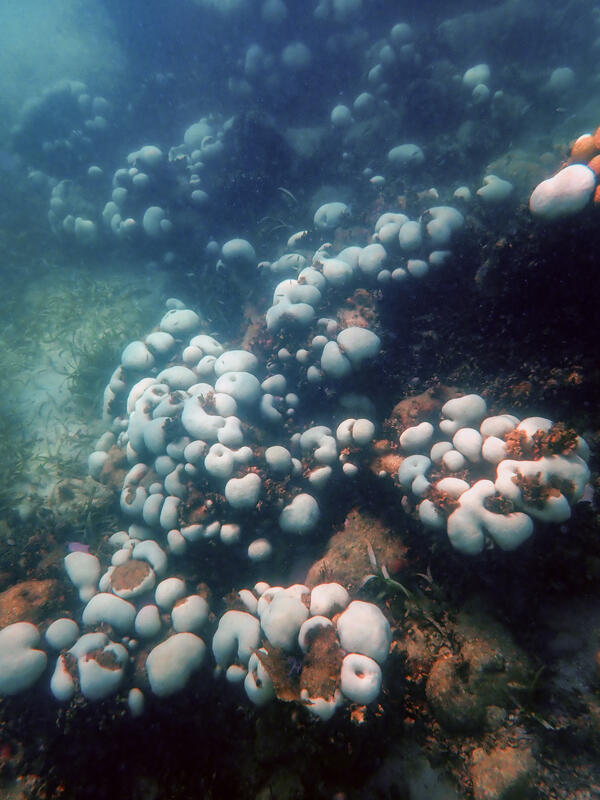
Key West Coral bleaching
Boulder star coral about 15 feet deep near the shore of Key West, Florida water are bleaching due to recent extreme water temperatures. Photo take July 18, 2023, by Lauren Toth, USGS.
Boulder star coral about 15 feet deep near the shore of Key West, Florida water are bleaching due to recent extreme water temperatures. Photo take July 18, 2023, by Lauren Toth, USGS.

Saildrone is towed into Lake Erie, July 2023
A Saildrone Explorer in the harbor being towed out onto Lake Erie for the beginning of a mission to collect data to improve fishery surveys on July 14, 2023.
A Saildrone Explorer in the harbor being towed out onto Lake Erie for the beginning of a mission to collect data to improve fishery surveys on July 14, 2023.

Saildrone is towed onto Lake Erie, July 2023
A Saildrone Explorer being towed on Lake Erie at the beginning of a mission to collect data to improve fishery surveys in July 2023.
A Saildrone Explorer being towed on Lake Erie at the beginning of a mission to collect data to improve fishery surveys in July 2023.

Saildrone at the dock in Erie, PA before launch
A Saildrone Explorer in the harbor before its launch on Lake Erie for the beginning of a mission to collect data to improve fishery surveys in July 2023.
A Saildrone Explorer in the harbor before its launch on Lake Erie for the beginning of a mission to collect data to improve fishery surveys in July 2023.

Saildrone is towed on Lake Erie, July 2023
A Saildrone Explorer being towed on Lake Erie at the beginning of a mission to collect data to improve fishery surveys in July 2023.
A Saildrone Explorer being towed on Lake Erie at the beginning of a mission to collect data to improve fishery surveys in July 2023.

Saildrone being towed into Lake Erie, July 2023
A Saildrone Explorer in the harbor being towed out onto Lake Erie for the beginning of a mission to collect data to improve fishery surveys on July 14, 2023.
A Saildrone Explorer in the harbor being towed out onto Lake Erie for the beginning of a mission to collect data to improve fishery surveys on July 14, 2023.

Saildrone being towed through the harbor in Erie, PA
Saildrone being towed through the harbor in Erie, PAA Saildrone Explorer being towed through the harbor in Erie, PA at the beginning of a mission to collect data to improve fishery surveys in July 2023.
Saildrone being towed through the harbor in Erie, PA
Saildrone being towed through the harbor in Erie, PAA Saildrone Explorer being towed through the harbor in Erie, PA at the beginning of a mission to collect data to improve fishery surveys in July 2023.

Saildrone being towed through Erie, PA harbor
A Saildrone Explorer being towed in the harbor in Erie, PA at the beginning of a mission to collect data to improve fishery surveys in July 2023.
A Saildrone Explorer being towed in the harbor in Erie, PA at the beginning of a mission to collect data to improve fishery surveys in July 2023.

Saildrone being towed on before launch on Lake Erie
Saildrone being towed on before launch on Lake ErieA Saildrone Explorer being towed through the harbor in Erie, PA at the beginning of a mission to collect data to improve fishery surveys in July 2023.
Saildrone being towed on before launch on Lake Erie
Saildrone being towed on before launch on Lake ErieA Saildrone Explorer being towed through the harbor in Erie, PA at the beginning of a mission to collect data to improve fishery surveys in July 2023.

Otter Creek Check
Sara Weaver, a USGS hydrologic technician, manually measures the water level of Otter Creek in Center Rutland, Vermont, July 12, 2023. USGS image.
Sara Weaver, a USGS hydrologic technician, manually measures the water level of Otter Creek in Center Rutland, Vermont, July 12, 2023. USGS image.

Science to Understand Changing Ecosystems
The USGS provides science to understand, protect, restore, and solve problems in the world around us, and that includes interconnected communities of living things called ecosystems.
The USGS provides science to understand, protect, restore, and solve problems in the world around us, and that includes interconnected communities of living things called ecosystems.

Preliminary topobathymetric digital elevation model of the Santiam River, OR.
Preliminary topobathymetric digital elevation model of the Santiam River, OR.Image of a preliminary topobathymetric digital elevation model captured of the of the Santiam River, OR.
Preliminary topobathymetric digital elevation model of the Santiam River, OR.
Preliminary topobathymetric digital elevation model of the Santiam River, OR.Image of a preliminary topobathymetric digital elevation model captured of the of the Santiam River, OR.

Celebration for the creation of a new USGS facility
Celebration for the creation of a new USGS facilityFederal, state, local and University of Hawai´i leaders and students celebrate the creation of a new facility that will monitor volcanoes and support conservation science.
Celebration for the creation of a new USGS facility
Celebration for the creation of a new USGS facilityFederal, state, local and University of Hawai´i leaders and students celebrate the creation of a new facility that will monitor volcanoes and support conservation science.

Interior Secretary, Deb Haaland, presented with lei.
Interior Secretary, Deb Haaland, presented with lei.Interior Secretary, Deb Haaland, presented with lei by David Phillips, Deputy Scientist-in-Charge of the USGS Hawaiian Volcano Observatory, during a ceremony to celebrate the creation of a new facility that will monitor volcanoes and support conservation science.
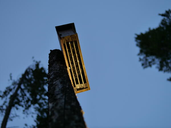
Bats roosting in a bat box
Bats roosting in a bat box during NABat Fieldwork in 2023.
Bats roosting in a bat box during NABat Fieldwork in 2023.
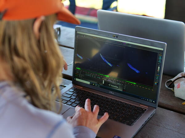
Examining an acoustic bat recording
Andrea Schuhmann examines an acoustic bat recording using a software for bat call analysis during NA Bat Fieldwork in 2023.
Andrea Schuhmann examines an acoustic bat recording using a software for bat call analysis during NA Bat Fieldwork in 2023.
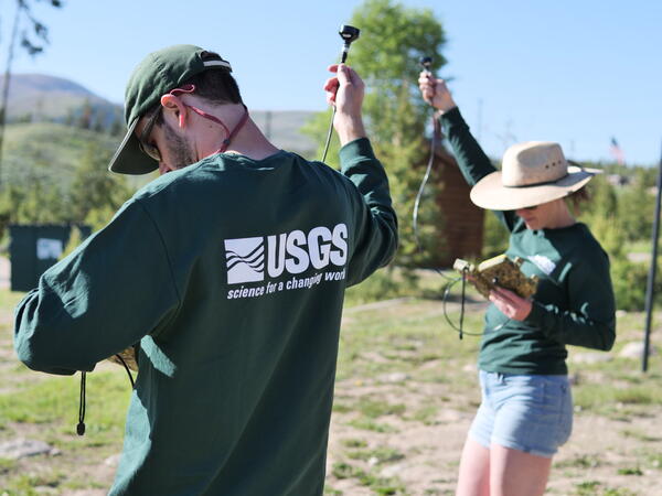
Testing acoustic microphones
Ben Lohre and Andrea Schuhmann test acoustic microphones prior to bat surveys, as part of the 2023 NABat field season.
Ben Lohre and Andrea Schuhmann test acoustic microphones prior to bat surveys, as part of the 2023 NABat field season.