
Photo of green forested area and blue sky overlooking the ocean in Kahanahāiki, Oʻahu on a sunny day.
Images
Images
Filter Total Items: 9454

Kahanahaiki_Oahu.JPG
Photo of green forested area and blue sky overlooking the ocean in Kahanahāiki, Oʻahu on a sunny day.

Alaka'i_cloud_forest2_Kauai.JPG
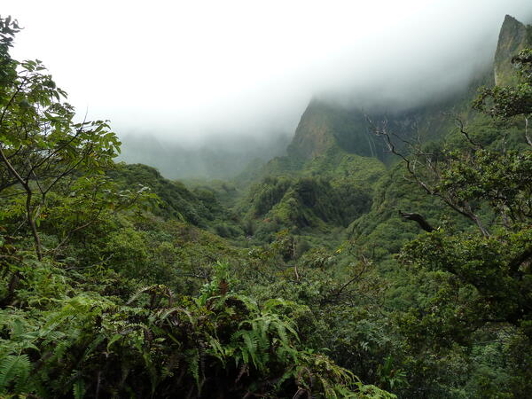
Photo of misty clouds in a forested area of Alakaʻi Wilderness Preserve, Kauaʻi.
Photo of misty clouds in a forested area of Alakaʻi Wilderness Preserve, Kauaʻi.

100K Topo map of Yuba City, California.
This is an example of an OnDemand 1:100,000 scale or 100K Topo map of Yuba City, California.
This is an example of an OnDemand 1:100,000 scale or 100K Topo map of Yuba City, California.

Area coverage difference between 100K Topo extent (red outline) and 7.5-Minute Topo (black outline) extent.
Area coverage difference between 100K Topo extent (red outline) and 7.5-Minute Topo (black outline) extent.Area coverage difference between 100K Topo extent (red outline) and 7.5-Minute Topo (black outline) extent.

Topobathymetric digital elevation model of the Kootenai River, Idaho.
Topobathymetric digital elevation model of the Kootenai River, Idaho.Topobathymetric digital elevation model of the Kootenai River, Idaho. Image was created by Cindy Thatcher.
Topobathymetric digital elevation model of the Kootenai River, Idaho.
Topobathymetric digital elevation model of the Kootenai River, Idaho.Topobathymetric digital elevation model of the Kootenai River, Idaho. Image was created by Cindy Thatcher.

Collecting water quality samples in the Grand Canyon
Collecting water quality samples in the Grand CanyonA USGS scientist collects water quality samples in the Grand Canyon in Arizona.
Collecting water quality samples in the Grand Canyon
Collecting water quality samples in the Grand CanyonA USGS scientist collects water quality samples in the Grand Canyon in Arizona.

Makamaka'ole_Stream_Maui_portrait.JPG
Photo of a lush green forested area around Makamaka‘ole Stream near Kānoa Ridge, Maui.
Photo of a lush green forested area around Makamaka‘ole Stream near Kānoa Ridge, Maui.

Makamaka'ole_Stream_Maui_landscape.JPG
Photo of lush green forested area around Makamaka‘ole Stream near Kānoa Ridge, Maui.
Photo of lush green forested area around Makamaka‘ole Stream near Kānoa Ridge, Maui.

Nakula_cloud_forest_Maui.JPG
Cloud covered forest landscape in Nakula, Maui with outlines of trees in the distance.
Cloud covered forest landscape in Nakula, Maui with outlines of trees in the distance.

Joe Hostler, environmental scientist, Yurok Tribe installing soil moisture probe
Joe Hostler, environmental scientist, Yurok Tribe installing soil moisture probeThe U.S. Geological Survey (USGS) often employs specific types of soil moisture probes to monitor watersheds, creeks, and streams as part of their hydrological studies and environmental monitoring efforts.
Yurok Ancestral Land at Sunset
The Yurok Tribe, one of the largest Native American tribes in California, has ancestral lands primarily located along the lower 45 miles of the Klamath River and the Pacific coast in the northwestern part of the state. These lands are situated in what is today Humboldt and Del Norte counties.
The Yurok Tribe, one of the largest Native American tribes in California, has ancestral lands primarily located along the lower 45 miles of the Klamath River and the Pacific coast in the northwestern part of the state. These lands are situated in what is today Humboldt and Del Norte counties.

New method to detect white-nose syndrome fungus in bats developed
New method to detect white-nose syndrome fungus in bats developedA new test for white-nose syndrome-causing fungus in bats has been developed using a CRISPR biosensor. If white-nose syndrome-causing fungus is present, the reaction tube will glow under UV light.

Colorado River, Grand Canyon
The Colorado River, brown from heightened suspended load following rains, flows through Paleoproteroic basement and overlying Cambrian Tapeats Sandstone in the Grand Canyon (Arizona, USA).
The Colorado River, brown from heightened suspended load following rains, flows through Paleoproteroic basement and overlying Cambrian Tapeats Sandstone in the Grand Canyon (Arizona, USA).

Scientist collects water sample in the Grand Canyon
Scientist collects water sample in the Grand CanyonUSGS scientist collects a water-quality sample in the Grand Canyon, Arizona.
Scientist collects water sample in the Grand Canyon
Scientist collects water sample in the Grand CanyonUSGS scientist collects a water-quality sample in the Grand Canyon, Arizona.
Iao_Valley_Maui.JPG
Clouds saturate a forest area in ‘Īao Valley, Maui through the process of cloud-water interception.
Clouds saturate a forest area in ‘Īao Valley, Maui through the process of cloud-water interception.

Wailua_Iki_Falls_Maui.JPG
Freshwater waterfall in lush green forested area named Wailua Iki Falls, Maui.
Freshwater waterfall in lush green forested area named Wailua Iki Falls, Maui.

Salt deposits outside Moab, UT
Salt deposits outside Moab, UT. USGS scientists are studying how salinity in the Upper Colorado Basin has changed over time and how factors like irrigation and climate influence salinity.
Salt deposits outside Moab, UT. USGS scientists are studying how salinity in the Upper Colorado Basin has changed over time and how factors like irrigation and climate influence salinity.

Salt deposits along the Paria River, UT
Salt deposits along the Paria River, UT. USGS scientists are studying salinity in the Upper Colorado Basin.
Salt deposits along the Paria River, UT. USGS scientists are studying salinity in the Upper Colorado Basin.

Dolores River, CO
The Dolores River, CO, a tributary of the Colorado River. USGS scientists are studying salinity in the Upper Colorado Basin.
The Dolores River, CO, a tributary of the Colorado River. USGS scientists are studying salinity in the Upper Colorado Basin.

HIVIS camera along the San Antonio River
A Hydrologic Imagery Visualization and Information System (HIVIS) camera along the San Antonio River in San Antonio, Texas. The camera is used to verify the position of a gate that is operated by the City of San Antonio. Check out the camera here.
A Hydrologic Imagery Visualization and Information System (HIVIS) camera along the San Antonio River in San Antonio, Texas. The camera is used to verify the position of a gate that is operated by the City of San Antonio. Check out the camera here.