
Austin Elliott with the USGS Earthquake Science Center prepares to carry Redwood stump samples out to the road.
Images
Images
Filter Total Items: 9454

A researcher with a bag of stump samples.
Austin Elliott with the USGS Earthquake Science Center prepares to carry Redwood stump samples out to the road.

Wedge sample removed from a redwood stump.
Wedge sample removed from a redwood stump at the base of the San Andreas fault scarp (slope up in the background).
Wedge sample removed from a redwood stump at the base of the San Andreas fault scarp (slope up in the background).

Redwood stump sample
Sample removed from a redwood stump, displaying annual rings. The sample will help researchers determine past earthquakes in the area.
Sample removed from a redwood stump, displaying annual rings. The sample will help researchers determine past earthquakes in the area.

A researcher stands between two sampled redwood stumps.
A researcher stands between two sampled redwood stumps.Nick Cunetta stands between two sampled redwood stumps on a pressure ridge between two strands of the San Andreas fault
A researcher stands between two sampled redwood stumps.
A researcher stands between two sampled redwood stumps.Nick Cunetta stands between two sampled redwood stumps on a pressure ridge between two strands of the San Andreas fault

Earth's Pulse
EARTH'S PULSE
Hazard Monitoring
Scientists rely on measurements and networks of sensors to monitor Earth’s movements. Similar to tracking someone’s pulse, these sensors check the ‘hazard heartbeat’ of Earth’s surface, waters, and air. Hazard monitoring helps us understand where, when, why, and how much things change over time.

The Cost of Biological Threats
MONITORING BIOLOGICAL THREATS: Protecting Ecosystems, Public Safety, and the Economy
MONITORING BIOLOGICAL THREATS: Protecting Ecosystems, Public Safety, and the Economy
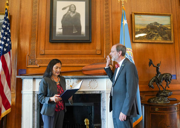
David Applegate Sworn In as USGS Director
Dr. David Applegate is sworn in by Interior Secretary Deb Haaland as USGS director.
Dr. David Applegate is sworn in by Interior Secretary Deb Haaland as USGS director.

Tres científicos del USGS que instalan equipos submarinos
Tres científicos del USGS que instalan equipos submarinosTres científicos del Servicio Geológico de los Estados Unidos en equipo de buceo instalando una boya de olas y un sensor de presión a 60 pies de profundad para medir las olas y niveles de agua en Isla Verde, Puerto Rico.

USGS scientists installing underwater equipment
Three U.S. Geological Survey scientists in scuba gear work to install a wave buoy and pressure sensor 60 feet underwater to measure waves and water levels in Isla Verde, Puerto Rico.
Three U.S. Geological Survey scientists in scuba gear work to install a wave buoy and pressure sensor 60 feet underwater to measure waves and water levels in Isla Verde, Puerto Rico.
IMG_7547.JPG
Landsat 9 handover between USGS Earth Resources Observation and Science and NASA.
Landsat 9 handover between USGS Earth Resources Observation and Science and NASA.

USGS Director David Applegate Delivers Remarks During the Celebration of USGS Advanced Technologies in Fisheries
USGS Director David Applegate Delivers Remarks During the Celebration of USGS Advanced Technologies in FisheriesUSGS Director David Applegate delivers remarks during the celebration of USGS advanced technologies in fisheries science on the Great Lakes, August 9, 2022, in Ashland, Wisconsin. Photo credit: Andrea Miehls, USGS.

USGS scientists set-up equipment on beach
Two U.S. Geological Survey scientists set-up equipment to survey a beach in Dorado, Puerto Rico. This equipment will monitor how the beach and shoreline change through time. USGS Image.
Two U.S. Geological Survey scientists set-up equipment to survey a beach in Dorado, Puerto Rico. This equipment will monitor how the beach and shoreline change through time. USGS Image.
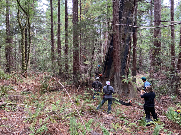
Researchers watch sawyers cutting into a leaning redwood snag.
Researchers watch sawyers cutting into a leaning redwood snag.Belle Philibosian, Nick Cunetta, and Allyson Carroll watch sawyers cutting into a leaning redwood snag. The snag is located directly on the San Andreas fault scarp (slope down to the right) and the leaning may have occurred during an earthquake.

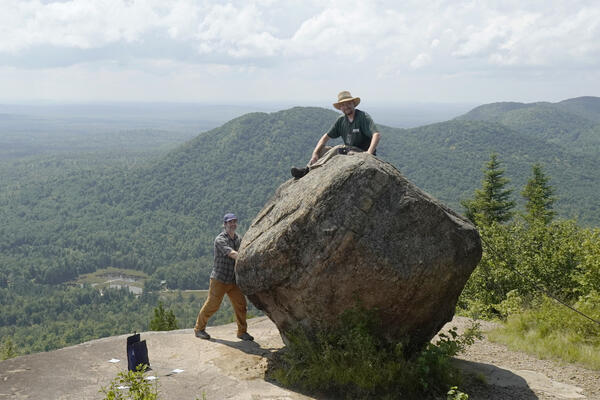
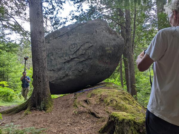
Studying precariously balanced rocks in northeastern U.S.
Studying precariously balanced rocks in northeastern U.S.Photo of a precariously balanced rock by Noah Lindberg from the northeastern U.S. taken during field work in August, 2022.
Studying precariously balanced rocks in northeastern U.S.
Studying precariously balanced rocks in northeastern U.S.Photo of a precariously balanced rock by Noah Lindberg from the northeastern U.S. taken during field work in August, 2022.

Studying precariously balanced rocks in northeastern U.S.
Studying precariously balanced rocks in northeastern U.S.Noah Lindberg and Thomas Pratt observe and measure features of a precariously balanced rock in the northeastern U.S.
Studying precariously balanced rocks in northeastern U.S.
Studying precariously balanced rocks in northeastern U.S.Noah Lindberg and Thomas Pratt observe and measure features of a precariously balanced rock in the northeastern U.S.
Studying precariously balanced rocks in northeastern U.S.
Studying precariously balanced rocks in northeastern U.S.Noah Lindberg installing a seismometer on a balanced rock on Azure Mountain in the Adirondacks.
Studying precariously balanced rocks in northeastern U.S.
Studying precariously balanced rocks in northeastern U.S.Noah Lindberg installing a seismometer on a balanced rock on Azure Mountain in the Adirondacks.

Studying precariously balanced rocks in northeastern U.S.
Studying precariously balanced rocks in northeastern U.S.Devin McPhillips closely examines the base of a rock perched on the edge of a cliff at Little Sawyer Mountain in the Adirondacks.
Studying precariously balanced rocks in northeastern U.S.
Studying precariously balanced rocks in northeastern U.S.Devin McPhillips closely examines the base of a rock perched on the edge of a cliff at Little Sawyer Mountain in the Adirondacks.
Studying precariously balanced rocks in northeastern U.S.
Studying precariously balanced rocks in northeastern U.S.Devin McPhillips collecting LIDAR for 3D modeling of the rock, while Tom Pratt is in the foreground taking pictures for 3D modeling using photogrammetry.
Studying precariously balanced rocks in northeastern U.S.
Studying precariously balanced rocks in northeastern U.S.Devin McPhillips collecting LIDAR for 3D modeling of the rock, while Tom Pratt is in the foreground taking pictures for 3D modeling using photogrammetry.

Studying precariously balanced rocks in northeastern U.S.
Studying precariously balanced rocks in northeastern U.S.Scientist measuring aspects of a precariously balanced rock in the northeastern U.S.
Studying precariously balanced rocks in northeastern U.S.
Studying precariously balanced rocks in northeastern U.S.Scientist measuring aspects of a precariously balanced rock in the northeastern U.S.

Belle Philibosian examines a redwood stump.
Belle Philibosian with the USGS Earthquake Science Center examines a redwood stump along the north coast section of the San Andreas Fault near Gualala, California in late August 2022.
Belle Philibosian with the USGS Earthquake Science Center examines a redwood stump along the north coast section of the San Andreas Fault near Gualala, California in late August 2022.

Sawyers cutting into a leaning redwood snag.
Sawyers cutting into a leaning redwood snag. The snag is located directly on the San Andreas fault scarp (slope down to the left) and the leaning may have occurred during an earthquake.
Sawyers cutting into a leaning redwood snag. The snag is located directly on the San Andreas fault scarp (slope down to the left) and the leaning may have occurred during an earthquake.