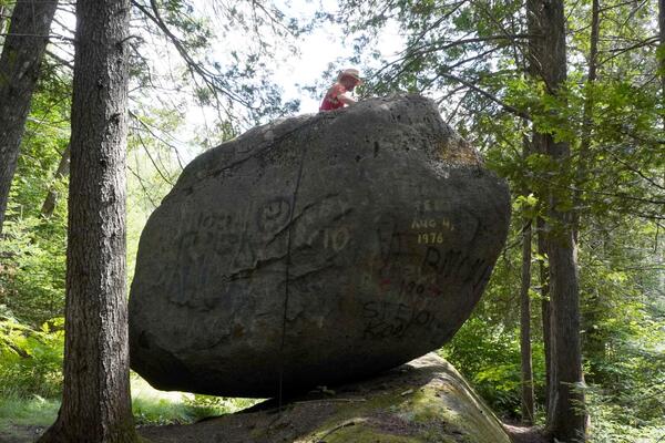
Map from the Great Salt Lake Water Dashboard from July 27th, 2022 showing the extent of the Great Salt Lake watershed. Markers are stream flow gages colored by flow status with warmer colors indicating below normal flow status, green as normal, and blue to black as above normal.
Images
Images
Map from the Great Salt Lake Water Dashboard from July 27th, 2022 showing the extent of the Great Salt Lake watershed. Markers are stream flow gages colored by flow status with warmer colors indicating below normal flow status, green as normal, and blue to black as above normal.
Utah Department of Natural Resources Great Salt Lake Characteristics Matrix
Utah Department of Natural Resources Great Salt Lake Characteristics MatrixMatrix from the Great Salt Hydro Mapper webpage on July 27th, 2022. The matrix shows a summary of resource characteristics at different lake elevation levels. Areas shaded green indicate the lake level is beneficial; areas shaded orange indicate the lake level is adverse for the resource.
Graph of water data from Great Salt Lake Saltair gaging station from January 2020 to July 2022
Graph of water data from Great Salt Lake Saltair gaging station from January 2020 to July 2022Graph of water data recorded by the Great Salt Lake (GSL) Saltair USGS Gaging Station 10010000 showing data from January 2020 to July 2022 from the
USGS technicians sample for fatmucket (Lampsilis siliquoidea) environmental-DNA in the Little Calumet River for a native mussel restoration project at Indiana Dunes National Park, Indiana. Photo credit: Ashley Spoljaric, USGS (contractor).
ARCTIC TERNS SPEND THEIR SUMMERS NESTING IN ALASKA AND PARTS OF THE ARCTIC. WHEN THE SEASON ENDS, THEY FLY SOUTH TO ANTARCTICA, EMBARKING ON THE LONGEST MIGRATION OF ANY ANIMAL ON EARTH!
ALTHOUGH OTHER BIRD DIE-OFFS HAD BEEN SEEN RECENTLY IN ALASKA, THERE WAS SOMETHING DIFFERENT ABOUT THE TERNS. THEY HAD BEEN POISONED.
BRIGHT GREEN ALGAE CAN OFTEN BE SPOTTED FLOATING IN THE OCEAN NEAR THE SURFACE. THEY CONSUME NUTRIENTS, LIKE NITROGEN AND PHOSPHORUS. IN A BALANCED ECOSYSTEM, THEY GROW AND PROVIDE FOOD FOR MANY SEA CREATURES, INCLUDING KRILL, SNAILS, AND JELLYFISH.
HOWEVER, IF WE WORK TOGETHER, WE CAN MAKE THINGS SAFER. THE ALASKA HARMFUL ALGAL BLOOM NETWORK ASSEMBLES PARTNERS TO SHARE INFORMATION ABOUT HUMAN, WILDLIFE, AND ECOSYSTEM HEALTH.
TERNS EAT KRILL AND FORAGE FISH LIKE HERRING AND SAND LANCE. USUALLY, THAT'S A NUTRITIOUS DIET. BUT WHEN HARMFUL ALGAL BLOOMS OCCUR, TOXINS CAN TAINT THE FOOD WEB FOR THE BIRDS.
SEABIRD DIE-OFFS IN ALASKA ARE BECOMING MORE FREQUENT. ALTHOUGH RESEARCHERS BELIEVE MOST BIRDS STARVE DURING THESE EVENTS, THERE MAY BE SOMETHING ELSE CONTRIBUTING TO SOME OF THE DEATHS -- HARMFUL ALGAL BLOOMS.
AS THE OCEAN WARMS AND FILLS WITH EXCESS NUTRIENTS FROM SURFACE RUNOFF, CERTAIN TYPES OF ALGAE CAN GROW OUT OF CONTROL AND PRODUCE DANGEROUS TOXINS.
TYPICALLY, THE HARMFUL ALGAE BLOOMS DURING THE SUMMER SEASON. THE WARMER TEMPERATURES KEEP WATER FROM MIXING, ALLOWING THE ALGAE TO GROW MUCH FASTER.
AS THE OCEAN WARMS AND FILLS WITH EXCESS NUTRIENTS FROM SURFACE RUNOFF, CERTAIN TYPES OF ALGAE CAN GROW OUT OF CONTROL AND PRODUCE DANGEROUS TOXINS.
TYPICALLY, THE HARMFUL ALGAE BLOOMS DURING THE SUMMER SEASON. THE WARMER TEMPERATURES KEEP WATER FROM MIXING, ALLOWING THE ALGAE TO GROW MUCH FASTER.
ALASKA HAS THOUSANDS OF MILES OF REMOTE COASTLINE. THIS MAKES IT DIFFICULT TO EFFECTIVELY MONITOR FOR ALGAL TOXINS, ALERT THE PUBLIC, AND TRACK IMPACTS ON WILDLIFE.
NOT ONLY ARE HARMFUL ALGAL BLOOMS IN THE OCEAN DANGEROUS FOR ARCTIC TERNS, THEY CAN ALSO IMPACT HUMAN FOOD SOURCES AND HEALTH.
DURING THE SUMMER OF 2019, DOZENS OF ARCTIC TERNS WERE FOUND DEAD. RESEARCHERS WONDERED, "WHAT HAPPENED?"
Landsat 8 Image of Washburn Fire, Yosemite National Park - July 7, 2022
Landsat 8 Image of Washburn Fire, Yosemite National Park - July 7, 2022The Landsat 8 thermal image of the Washburn fire was acquired at night to pinpoint the location (bright white) of heat from the fire as it began. Firefighters immediately focused on suppressing the wildfire to minimize any effects on the Mariposa Grove of Giant Sequoias. As of July 18, 2022, the fire covered nearly 5,000 acres.
Landsat 9 Image of Washburn Fire, Yosemite National Park - July 7, 2022
Landsat 9 Image of Washburn Fire, Yosemite National Park - July 7, 2022The Washburn Fire started July 7, 2022 in the southern part of Yosemite National Park. Landsats 8 and 9 both captured imagery of it a day later. The Landsat 9 image uses shortwave infrared and near-infrared bands to show the active burning.
This helicopter will fly along pre-planned flight paths in the Coalinga area at a relatively low to the ground at 100-200 feet above the surface. A sensor that resembles a large hula-hoop will be towed beneath the helicopter to measure small electromagnetic signals that can be used to map geologic features below Earth’s surface.
Image of a western meadowlark, a grassland-dwelling bird species. Credit: USFWS, public domain
Map of the M 3.5 - 6 km E of Elgin, South Carolina on June 29,2022
Map of the M 3.5 - 6 km E of Elgin, South Carolina on June 29,2022A map showing the epicenter of the M 3.5 quake that occurred 3.7 miles (6 km) east of Elgin, South Carolina on June 29, 2022. The quake is part of an ongoing sequence in central South Carolina. The sequence started on December 27, 2021, with an M3.3 earthquake near Lugoff, South Carolina.
Boaters fly fishing on the Missouri River in Montana
Installing natural infrastructure can impact the water and carbon budgets of dryland streams and watersheds
Installing natural infrastructure can impact the water and carbon budgets of dryland streams and watershedsAn illustration of a mountain with water flowing from the top down to a river with smaller rivers flowing off the sides. Multiple items appear along the various rivers including leaky weirs, one rock dams, log dams, gabions, check dams, trincheras, and earthen berms. Informational bubbles appear alongside these various item in the illustration.