
This graphic shows a snow-capped mountain with the words “From Snow to Flow” written on the bottom left corner. Next to the mountain, hovering in the air, is a illustration of a drone. On the bottom right corner is an illustration of a ground-based satellite.
Images
Images
Filter Total Items: 9454

SnowtoFlowThumbnail.png
This graphic shows a snow-capped mountain with the words “From Snow to Flow” written on the bottom left corner. Next to the mountain, hovering in the air, is a illustration of a drone. On the bottom right corner is an illustration of a ground-based satellite.

Scientist Banner 2.png
USGS Scientists Evan Gohring, Andy Creighton, Mark Bauer, and Victoria Scholl.
USGS Scientists Evan Gohring, Andy Creighton, Mark Bauer, and Victoria Scholl.

Oregon Spotted Frog
While surveying for Oregon spotted frog egg masses in Deschutes County, OR, field technicians caught an adult female using a dip net. This was the first individual observed during the Spring field season.
While surveying for Oregon spotted frog egg masses in Deschutes County, OR, field technicians caught an adult female using a dip net. This was the first individual observed during the Spring field season.

Scientist Banner 2.png
USGS Scientists Evan Gohring, Andy Creighton, Mark Bauer, and Victoria Scholl.
USGS Scientists Evan Gohring, Andy Creighton, Mark Bauer, and Victoria Scholl.

SnowtoFlow_MountainWaterGlass.png
A graphic shows a snow-capped mountain. The snowpack on top of the mountain is melting into a water glass to show that snowmelt makes its way to water users.
A graphic shows a snow-capped mountain. The snowpack on top of the mountain is melting into a water glass to show that snowmelt makes its way to water users.

SnowtoFlowScienceTeam_withBanner.png
The Snow to Flow team is comprised of a “village” of remarkable scientists and engineers from the USGS Colorado Water Science Center, USGS National Uncrewed Systems Office (NUSO), and the University of Southern California - Viterbi School of Engineering. The team is pictured here at the Berthoud Pass, CO field site on April 18, 2022.
The Snow to Flow team is comprised of a “village” of remarkable scientists and engineers from the USGS Colorado Water Science Center, USGS National Uncrewed Systems Office (NUSO), and the University of Southern California - Viterbi School of Engineering. The team is pictured here at the Berthoud Pass, CO field site on April 18, 2022.

Mendenhall Fellows Noa Randall and Rachel Allen Do Fieldwork
Mendenhall Fellows Noa Randall and Rachel Allen Do FieldworkNoa Randall and Rachel Allen are installing an optical turbidity sensor on the mudflats in Wellfleet harbor, to pair with the altimeter run by the Center for Coastal Studies. The Herring River, which drains into Wellfleet Harbor, is slated to have its 100-yo dam removed in the next 6 months, with the potential to dramatically increase the sediment load and sus

Group photo 2 by Matt Burgess NUSO.JPG
The Snow to Flow team is comprised of a “village” of remarkable scientists and engineers from the USGS Colorado Water Science Center, USGS National Uncrewed Systems Office (NUSO), and the University of Southern California - Viterbi School of Engineering. The team is pictured here at the Berthoud Pass, CO field site on April 18, 2022.
The Snow to Flow team is comprised of a “village” of remarkable scientists and engineers from the USGS Colorado Water Science Center, USGS National Uncrewed Systems Office (NUSO), and the University of Southern California - Viterbi School of Engineering. The team is pictured here at the Berthoud Pass, CO field site on April 18, 2022.

USGS Biologist Amanda Milde with 80-lb bighead carp
USGS Biologist Amanda Milde with 80-lb bighead carpUSGS Biologist Amanda Milde holds a 79 lb bighead carp captured, tagged, and released in Pool 18 of the Mississippi.
USGS Biologist Amanda Milde with 80-lb bighead carp
USGS Biologist Amanda Milde with 80-lb bighead carpUSGS Biologist Amanda Milde holds a 79 lb bighead carp captured, tagged, and released in Pool 18 of the Mississippi.
WestonWeberHeadshot.JPG
Headshot of Weston Weber. Weston is a Public Affairs Specialist with the Eastern States Office of Communications.
Headshot of Weston Weber. Weston is a Public Affairs Specialist with the Eastern States Office of Communications.

Pennington Mountain Critical Minerals
Geologists in the field at Pennington Mountain. The orange instrument is a portable gamma spectrometer. University of Maine-Presque Isle professor Chunzeng Wang (the lead author) is in front, Preston Bass is carrying the meter.
Geologists in the field at Pennington Mountain. The orange instrument is a portable gamma spectrometer. University of Maine-Presque Isle professor Chunzeng Wang (the lead author) is in front, Preston Bass is carrying the meter.

Super streamgage on the Wabash River near New Harmony, IN.
Super streamgage on the Wabash River near New Harmony, IN.A super streamgage sits inside the brown structure underneath the bridge over the Wabash River linking Indiana and Illinois. The closest town is New Harmony, IN.
Super streamgage on the Wabash River near New Harmony, IN.
Super streamgage on the Wabash River near New Harmony, IN.A super streamgage sits inside the brown structure underneath the bridge over the Wabash River linking Indiana and Illinois. The closest town is New Harmony, IN.

Mountain Pass REE mine in California
Open pit rare earth element mine at Mountain Pass, California. Stepped sides of the pit and access for mining vehicles are shown.
Open pit rare earth element mine at Mountain Pass, California. Stepped sides of the pit and access for mining vehicles are shown.

Airborne Geophysical Survey Helicopter with Cow
A helicopter rigged with an airborne geophysical survey collecting equipment. Information collected during these surveys can help with studying critical mineral resources, natural hazards and groundwater potential. A cow is here too.
A helicopter rigged with an airborne geophysical survey collecting equipment. Information collected during these surveys can help with studying critical mineral resources, natural hazards and groundwater potential. A cow is here too.

Airborne Geophysical Survey Helicopter in Nevada
A low-flying helicopter towing a geophysical device collects scientific data on groundwater and geology. Information collected during these surveys can help with studying critical mineral resources, natural hazards and groundwater potential.
A low-flying helicopter towing a geophysical device collects scientific data on groundwater and geology. Information collected during these surveys can help with studying critical mineral resources, natural hazards and groundwater potential.
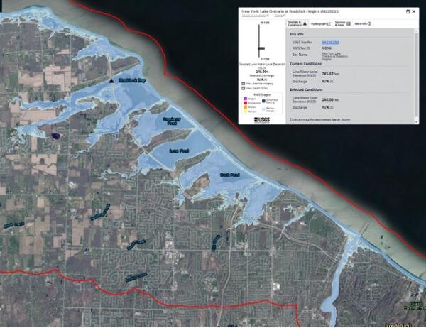
USGS Flood Inundation Mapper of Lake Ontario's New York shoreline
USGS Flood Inundation Mapper of Lake Ontario's New York shorelineScreenshot of the USGS Flood Inundation Mapper shows the Lake Ontario shoreline at Braddock Heights. USGS image.
USGS Flood Inundation Mapper of Lake Ontario's New York shoreline
USGS Flood Inundation Mapper of Lake Ontario's New York shorelineScreenshot of the USGS Flood Inundation Mapper shows the Lake Ontario shoreline at Braddock Heights. USGS image.

Carbon Rainbow
COLORS OF THE CARBON RAINBOW
Not All Carbon is the Same
Scientists use color to classify carbon at different points in the carbon cycle based on carbon function, characteristics, and location. This creates a more descriptive framework than traditional "organic" and "inorganic" labels.
COLORS OF THE CARBON RAINBOW
Not All Carbon is the Same
Scientists use color to classify carbon at different points in the carbon cycle based on carbon function, characteristics, and location. This creates a more descriptive framework than traditional "organic" and "inorganic" labels.
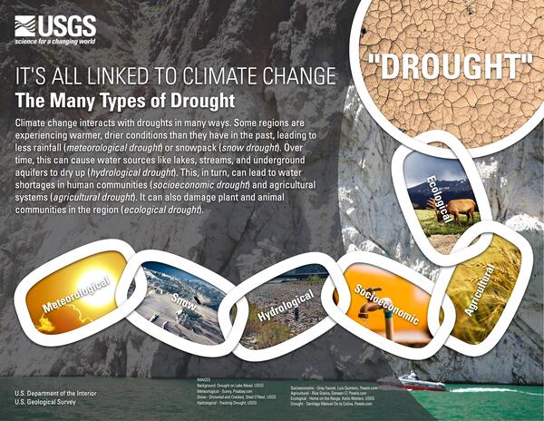
It's All Linked to Climate Change
Climate change interacts with droughts in many ways. Some regions are experiencing warmer, drier conditions than they have in the past, leading to less rainfall (meteorological drought) or snowpack (snow drought). Over time, this can cause water sources like lakes, streams, and underground aquifers to dry up (hydrological drought).
Climate change interacts with droughts in many ways. Some regions are experiencing warmer, drier conditions than they have in the past, leading to less rainfall (meteorological drought) or snowpack (snow drought). Over time, this can cause water sources like lakes, streams, and underground aquifers to dry up (hydrological drought).

topoBuilder Infographic
topoBuilder & OnDemand Topo Capabilities
topoBuilder & OnDemand Topo Capabilities

Horseshoe Bend Topographic Map from topoBuilder
A topographic map of Horseshoe Bend, part of the Grand Canyon in Arizona, made with topoBuilder.
A topographic map of Horseshoe Bend, part of the Grand Canyon in Arizona, made with topoBuilder.

topoBuilder Infographic Smoothing Options
A comparison of low, medium (default), and high contour smoothing options available from the topoBuilder application.
A comparison of low, medium (default), and high contour smoothing options available from the topoBuilder application.