
In the snowpit, Evan collects snow depth, snow density, and weather data at Berthoud Pass, CO.
Images
Images
Filter Total Items: 9454
SnowPitEvanGohring.png
In the snowpit, Evan collects snow depth, snow density, and weather data at Berthoud Pass, CO.

Collecting Snow Data
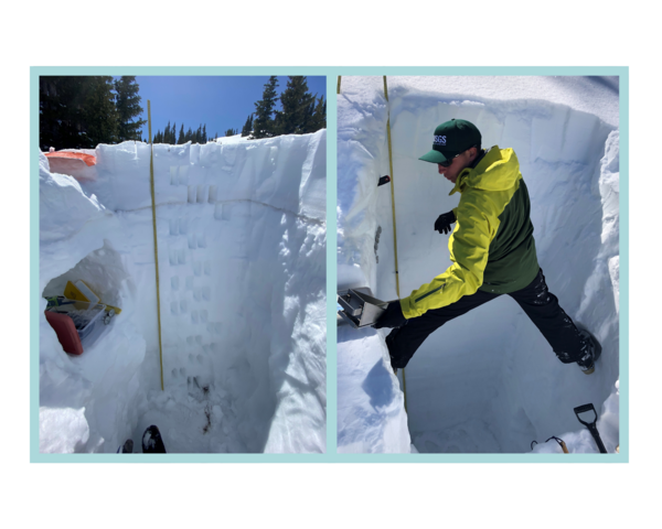
Two photos are arranged side by side. In the first photo, the photographer stands at the bottom of the snowpit. We can see how deep the snowpit is – about the length of a ski from tip to tail. There is a shelf dug into the side of the pit that holds science gear.
Two photos are arranged side by side. In the first photo, the photographer stands at the bottom of the snowpit. We can see how deep the snowpit is – about the length of a ski from tip to tail. There is a shelf dug into the side of the pit that holds science gear.

Mark 2.png
Mark communicates with the ground team (including Evan and Andy) to let them know that the USGS UAS is starting its flight over the snowpack.
Mark communicates with the ground team (including Evan and Andy) to let them know that the USGS UAS is starting its flight over the snowpack.

Victoria 2.png
Victoria Scholl, USGS Physical Scientist. This graphic shows a quote from Victoria’s narrative. It reads: “My background is in imaging science: the capture, processing, display, and analysis of imagery.“ Yellow quotation marks bookend her quote.
Victoria Scholl, USGS Physical Scientist. This graphic shows a quote from Victoria’s narrative. It reads: “My background is in imaging science: the capture, processing, display, and analysis of imagery.“ Yellow quotation marks bookend her quote.

Mark 3.png
Mark checks the spatial data downloaded from the drone to make sure that the first UAS flight accurately collected snowpack data.
Mark checks the spatial data downloaded from the drone to make sure that the first UAS flight accurately collected snowpack data.
GPR_Sled.png
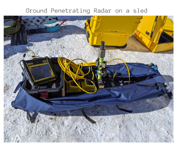
The ground penetration radar is set up on a sled, ready to be pulled behind a skier. The sled is covered in blue canvas. The radar is a combination of yellow and black computer gear and a neon green foot-long sensor. Yellow crates and skis dot the background of the image.
The ground penetration radar is set up on a sled, ready to be pulled behind a skier. The sled is covered in blue canvas. The radar is a combination of yellow and black computer gear and a neon green foot-long sensor. Yellow crates and skis dot the background of the image.

AndyCreighton.png
Andy Creighton, USGS Hydrologist. A photo shows USGS scientist Andy Creighton smiling at the camera. Andy is on a pair of dark skis posing in a filed of snow. Behind her, rocky mountains are dusted in snow and evergreen trees. Andy is wearing bright snow gear that includes yellow ski boots, red ski pants, a turquoise hoodie, and a yellow backpack.
Andy Creighton, USGS Hydrologist. A photo shows USGS scientist Andy Creighton smiling at the camera. Andy is on a pair of dark skis posing in a filed of snow. Behind her, rocky mountains are dusted in snow and evergreen trees. Andy is wearing bright snow gear that includes yellow ski boots, red ski pants, a turquoise hoodie, and a yellow backpack.

Andy 4.png
Andy pulls the ground-penetrating radar (GPR) behind her on a sled. A photo shows USGS scientist Andy Creighton smiling at the camera. Andy is on a pair of dark skis posing in a filed of snow. Behind her, rocky mountains are dusted in snow and evergreen trees.
Andy pulls the ground-penetrating radar (GPR) behind her on a sled. A photo shows USGS scientist Andy Creighton smiling at the camera. Andy is on a pair of dark skis posing in a filed of snow. Behind her, rocky mountains are dusted in snow and evergreen trees.

Victoria 1.png
Victoria Scholl, USGS Physical Scientist. A photo shows USGS scientist Victoria Scholl smiling off to the right of the photographer. Victoria stands in front of a gravel parking lot with mountains in the background. Victoria is using an iPad and controller to pilot a drone. Victoria wears a brimmed-hat, sunglasses, and a grey T-shirt.
Victoria Scholl, USGS Physical Scientist. A photo shows USGS scientist Victoria Scholl smiling off to the right of the photographer. Victoria stands in front of a gravel parking lot with mountains in the background. Victoria is using an iPad and controller to pilot a drone. Victoria wears a brimmed-hat, sunglasses, and a grey T-shirt.

Evan 1.png
Evan Gohring, USGS Hydrologic Technician. A photo shows USGS scientist Evan Gohring smiling at the camera. Evan is wearing a T-shirt with the USGS logo on it. He is also wearing a ballcap and Evan is standing in front of a stand of aspen trees and a field of snow.
Evan Gohring, USGS Hydrologic Technician. A photo shows USGS scientist Evan Gohring smiling at the camera. Evan is wearing a T-shirt with the USGS logo on it. He is also wearing a ballcap and Evan is standing in front of a stand of aspen trees and a field of snow.

Andy 2.png
Dr. Andy Creighton, USGS Hydrologist. This graphic shows a quote from Andy’s narrative. It reads: “This is my first permanent government position, now I get to ski and do alpine hydrogeophysics - talk about a dream job!“ Yellow quotation marks bookend her quote.
Dr. Andy Creighton, USGS Hydrologist. This graphic shows a quote from Andy’s narrative. It reads: “This is my first permanent government position, now I get to ski and do alpine hydrogeophysics - talk about a dream job!“ Yellow quotation marks bookend her quote.

Mark 1.png
Mark Bauer, USGS Geographer. A photo shows USGS scientist Mark Bauer smiling at the camera. Mark is kneeling and holding the USGS drone with both hands. Mark wears a ballcap and an orange vest over his green USGS T-shirt. Behind Mark is a field of brown grass and a leaf-less tree sits in the background.
Mark Bauer, USGS Geographer. A photo shows USGS scientist Mark Bauer smiling at the camera. Mark is kneeling and holding the USGS drone with both hands. Mark wears a ballcap and an orange vest over his green USGS T-shirt. Behind Mark is a field of brown grass and a leaf-less tree sits in the background.

SnowpitPanorama.png
Evan and the team dug a snowpit to collect snowpack data at Berthoud Pass, CO.
Evan and the team dug a snowpit to collect snowpack data at Berthoud Pass, CO.

Andy 3.png
Dr. Andy Creighton, USGS Hydrologist. This graphic shows a quote from Andy’s narrative. It reads: “I was the first woman to be a part of a self-sustained snowmachine expedition across the North Slope of Alaska. It was amazing to be able to break down some of those barriers that are still in place for women in science.” Yellow quotation marks bookend her quote.
Dr. Andy Creighton, USGS Hydrologist. This graphic shows a quote from Andy’s narrative. It reads: “I was the first woman to be a part of a self-sustained snowmachine expedition across the North Slope of Alaska. It was amazing to be able to break down some of those barriers that are still in place for women in science.” Yellow quotation marks bookend her quote.

Mark 4.png
Mark Bauer, USGS Geographer. This graphic shows a quote from Mark’s narrative. It reads: “The program continued to grow, and as a remote pilot and geospatial analyst, I grew along with it.“ Yellow quotation marks bookend her quote.
Mark Bauer, USGS Geographer. This graphic shows a quote from Mark’s narrative. It reads: “The program continued to grow, and as a remote pilot and geospatial analyst, I grew along with it.“ Yellow quotation marks bookend her quote.

Victoria 4.png
Victoria works on the USGS UAS equipment. Victoria is crouched down in the snow, working on the USGS drone. The drone is black with yellow accents. Victoria is wearing dark snowgear and a ballcap. Snow covers the foreground. In the distant background, snowy mountains and a few evergreen trees dot the landscape.
Victoria works on the USGS UAS equipment. Victoria is crouched down in the snow, working on the USGS drone. The drone is black with yellow accents. Victoria is wearing dark snowgear and a ballcap. Snow covers the foreground. In the distant background, snowy mountains and a few evergreen trees dot the landscape.

Snow water equivalent.png
This graphic shows how snow-water equivalent is calculated. A grey jar with a red lid dominate the graphic. Inside the jar is snow. On the top, the snow is loosely layered. On the bottom of the jar, the snow is more compact. Text alongside the right of the jar reads “snow depth.”
This graphic shows how snow-water equivalent is calculated. A grey jar with a red lid dominate the graphic. Inside the jar is snow. On the top, the snow is loosely layered. On the bottom of the jar, the snow is more compact. Text alongside the right of the jar reads “snow depth.”

ScientistS2F_Thumbnail.png
A graphic showing a mountain with a snowcap. Names of scientists are next to arrows that show where on the mountain they work to measure snowmelt.
A graphic showing a mountain with a snowcap. Names of scientists are next to arrows that show where on the mountain they work to measure snowmelt.

Kristen Bennett sets up an instrument to acquire detailed topographic information for a complex esker system.
Kristen Bennett sets up an instrument to acquire detailed topographic information for a complex esker system.Kristen Bennett setting up a Terrestrial Laser Scanner (ground-based LiDAR) to acquire detailed topographic information for a complex esker system. The Breiðamerkurjökull glacier is visible in the background.

Helicopter collecting new technology and methods for water data
Helicopter collecting new technology and methods for water dataHelicopter flights will test new technology and methods to collect water-velocity (speed) data from camera images. (Credit: USGS)
Helicopter collecting new technology and methods for water data
Helicopter collecting new technology and methods for water dataHelicopter flights will test new technology and methods to collect water-velocity (speed) data from camera images. (Credit: USGS)

Low-level flight helicopter with stinger
Helicopter conducting low-level flights. Image courtesy Sander Geophysics Ltd.
Helicopter conducting low-level flights. Image courtesy Sander Geophysics Ltd.