
A Portrait of George Rogers Mansfield. Washington, D.C. 1934. Mansfield was a geologist.
Images
Images
Filter Total Items: 9454
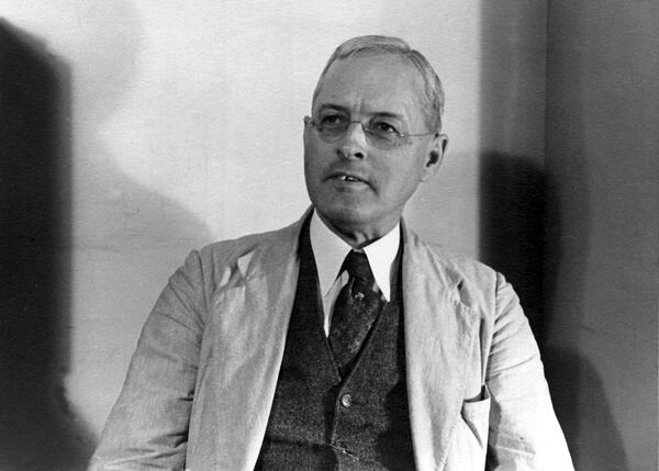
George Rogers Mansfield. Washington, D.C. 1934.
A Portrait of George Rogers Mansfield. Washington, D.C. 1934. Mansfield was a geologist.

USGS station 08110500 Navasota Riv. near Easterly, Tex.
USGS station 08110500 Navasota Riv. near Easterly, Tex.U.S. Geological Survey streamflow-gaging station 08110500 Navasota River near Easterly, Texas, looking upstream, June 7, 1934.
SIR 2009–5174
USGS station 08110500 Navasota Riv. near Easterly, Tex.
USGS station 08110500 Navasota Riv. near Easterly, Tex.U.S. Geological Survey streamflow-gaging station 08110500 Navasota River near Easterly, Texas, looking upstream, June 7, 1934.
SIR 2009–5174

Bird Migration Card - 1933
Image scan of a historical bird migration card.
Image scan of a historical bird migration card.

USGS Topographer at Work
Topographer George Stanley Druhot with a plane table and alidade. Recorder R.H. Moore is sitting against the Pierce Arrow in the background. A stadia rod is visible on the second car.
Topographer George Stanley Druhot with a plane table and alidade. Recorder R.H. Moore is sitting against the Pierce Arrow in the background. A stadia rod is visible on the second car.

USGS Topographer at Work
A topographer maps the north half of the Lovelock 1-degree quadrangle in the desert area near Jungo, Nevada. The umbrella protected the instrument from temperature variations.
A topographer maps the north half of the Lovelock 1-degree quadrangle in the desert area near Jungo, Nevada. The umbrella protected the instrument from temperature variations.

USGS Topographers at Work
A topographic field party crossing a snowdrift at the head of Grand Creek above their camp near Moose Lake while mapping the Mt. Constance quadrangle in the Olympic Mountains of Washington.
A topographic field party crossing a snowdrift at the head of Grand Creek above their camp near Moose Lake while mapping the Mt. Constance quadrangle in the Olympic Mountains of Washington.

USGS Topographer at Work
A USGS topographer works with a plane table and alidade to create a 1:180,000 scale topographic map near Imlay, Nevada. The umbrella is to protect the instrument from temperature variations.
A USGS topographer works with a plane table and alidade to create a 1:180,000 scale topographic map near Imlay, Nevada. The umbrella is to protect the instrument from temperature variations.

USGS Topographer at Work
Topographer George Stanley Druhot working with a tripod, planetable, and alidade at Kahekili Leap, on the island of Oahu. His two companions are Malcolm Springer and Tai Hai Lau
Topographer George Stanley Druhot working with a tripod, planetable, and alidade at Kahekili Leap, on the island of Oahu. His two companions are Malcolm Springer and Tai Hai Lau

USGS Topographers at Work
Two topographers working with an alidade and plane table. The man on the right is believed to be Roland Whitman Burchard, who was the topographer for the USGS Grand Canyon Expedition of 1923. Author Lewis Freeman described Burchard as a man of "powerful physique, great endurance, and a cool, steady hand."
Two topographers working with an alidade and plane table. The man on the right is believed to be Roland Whitman Burchard, who was the topographer for the USGS Grand Canyon Expedition of 1923. Author Lewis Freeman described Burchard as a man of "powerful physique, great endurance, and a cool, steady hand."

USGS Topographer at Work
Topographer George Stanley Druhot running a level line on oil-shale cliffs north of the Colorado River. The level line was one mile long and climbed 2,000 feet over talus slopes.
Topographer George Stanley Druhot running a level line on oil-shale cliffs north of the Colorado River. The level line was one mile long and climbed 2,000 feet over talus slopes.

USGS Topographer at Work
R.R. Monbeck on the rim of Haleakala volcano on the island of Maui
R.R. Monbeck on the rim of Haleakala volcano on the island of Maui

Lees Ferry on the Colorado River, Arizona, 1923
September 21, 1923, 9:00 a.m. --- Colorado River at Lees Ferry. From right bank on line with Klohr's house and gage house. Old "Dugway" or inclined gage shows to left of gage house. Gage height 11.05', discharge 27,000 cfs. Lens 16, time =1/25, camera supported. Photo by G.C. Stevens of the USGS. Source: 1921-1937 Surface Water Records File, Colorado R.
September 21, 1923, 9:00 a.m. --- Colorado River at Lees Ferry. From right bank on line with Klohr's house and gage house. Old "Dugway" or inclined gage shows to left of gage house. Gage height 11.05', discharge 27,000 cfs. Lens 16, time =1/25, camera supported. Photo by G.C. Stevens of the USGS. Source: 1921-1937 Surface Water Records File, Colorado R.

The Grand Canyon survey party at Lees Ferry.
The Grand Canyon survey party at Lees Ferry. Left to right: Leigh Lint, boatman; H.E. Blake, boatman; Frank Word, cook; C.H. Birdseye, expedition leader; R.C. Moore, geologist; R.W. Burchard, topographer; E.C. LaRue, hydraulic engineer; Lewis Freeman, boatman, and Emery Kolb, head boatman.
The Grand Canyon survey party at Lees Ferry. Left to right: Leigh Lint, boatman; H.E. Blake, boatman; Frank Word, cook; C.H. Birdseye, expedition leader; R.C. Moore, geologist; R.W. Burchard, topographer; E.C. LaRue, hydraulic engineer; Lewis Freeman, boatman, and Emery Kolb, head boatman.

Bird Migration Card - 1922
Image scan of a historical bird migration card.
Image scan of a historical bird migration card.

USGS Topographic Rod man
Rod man Koontz holding a stadia rod.
Rod man Koontz holding a stadia rod.
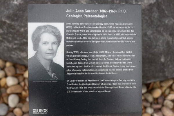
A placard featuring Julia Anna Gardner.
A placard featuring Julia Anna Gardner that is part of the Veteran's Memorial outside of the John Wesley Powell Federal Building in Reston, Va.
A placard featuring Julia Anna Gardner that is part of the Veteran's Memorial outside of the John Wesley Powell Federal Building in Reston, Va.

Triangulation Tower
USGS triangulation tower in West Texas.
USGS triangulation tower in West Texas.
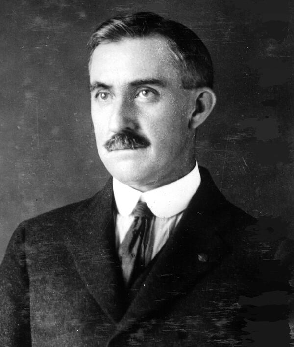
Oscar Edward Meinzer, First Chief, USGS Groundwater Resources. Circa 1916.
Oscar Edward Meinzer, First Chief, USGS Groundwater Resources. Circa 1916.Oscar Edward Meinzer, First Chief, Groundwater Resources. He was an early or first scientist to recognize the elasticity of soils, and artesian wells, and its importance, to measuring water resources. circa 1916.

Cimarron River Bed Operations in Cushing Oil Field
Cimarron River Bed Operations in Cushing Oil FieldThe panorama shows Cimarron River-bed operations in a portion of the Cushing Oil Field on December 2, 1915. The view is looking to the southwest from a river overlook located in Creek County, Oklahoma. The panorama was constructed from two photographs taken by A.E. Fath

Forsythe Peak and Dorothy Lake, Yosemite National Park, 1913
Forsythe Peak and Dorothy Lake, Yosemite National Park, 1913Forsythe Peak and Dorothy Lake, Yosemite National Park, 1913. Photograph by Richard B. Dole, U.S. Geological Survey
Forsythe Peak and Dorothy Lake, Yosemite National Park, 1913
Forsythe Peak and Dorothy Lake, Yosemite National Park, 1913Forsythe Peak and Dorothy Lake, Yosemite National Park, 1913. Photograph by Richard B. Dole, U.S. Geological Survey

Hauling drinking water, Upper St. Mary’s Lake, Glacier NP, 1913
Hauling drinking water, Upper St. Mary’s Lake, Glacier NP, 1913Hauling drinking water from Upper St. Mary’s Lake, Glacier National Park, 1913. Photograph by Richard B. Dole, U.S. Geological Survey
Hauling drinking water, Upper St. Mary’s Lake, Glacier NP, 1913
Hauling drinking water, Upper St. Mary’s Lake, Glacier NP, 1913Hauling drinking water from Upper St. Mary’s Lake, Glacier National Park, 1913. Photograph by Richard B. Dole, U.S. Geological Survey