
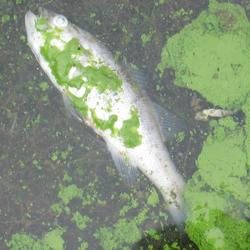


Landsat satellites captured this image of Lake Erie during a harmful algal bloom event.
Remote Sensing Provides a National View of Cyanobacteria Blooms
Completed
By Environmental Health Program
December 21, 2015
MERIS Image Showing Cyanobacteria Concentrations
Four Federal agencies, including the U.S. Geological Survey (USGS), are collaborating to transform satellite data into information managers can use to protect ecological and human health from freshwater contaminated by harmful algal blooms.
The U.S. Environmental Protection Agency (EPA), National Aeronautics and Space Administration (NASA), the National Oceanic and Atmospheric Administration (NOAA), and the USGS are collaborating to develop a method to detect and measure cyanobacteria blooms in freshwater systems using satellite data in order to support the environmental management and public use of U.S. lakes and reservoirs.

Sources/Usage: Public Domain. View Media Details
Cyanobacteria are a genetically diverse group of photosynthetic microorganisms (formerly known as blue-green algae) that occupy a broad range of habitats on land and water all over the world. Under certain environmental conditions (including excessive nutrients), cyanobacteria rapidly multiply to create a bloom that is sometimes referred to as a cyanobacterial harmful algal bloom (cyanoHAB). Some cyanobacteria produce toxins that can kill wildlife and domestic animals and cause illness or death in humans through exposure to contaminated freshwater or by the consumption of contaminated drinking water, fish, or shellfish. CyanoHABs are a worldwide environmental health problem that poses an expensive, unpredictable public health threat that can affect millions of people. In the United States, the cost of freshwater degraded by harmful algal blooms is estimated to be at least $64 million annually. In August 2014, officials in Toledo, Ohio, banned the use of drinking water supplied to more than 400,000 residents after it was contaminated by an algal bloom in Lake Erie.
CyanoHABs are a product of a complex set of natural and anthropogenic influences that make it challenging to provide early warning for public health protection and to minimize socioeconomic impact. Rapid detection of potentially harmful blooms is essential to protect humans and animals from exposure. Development of a scientifically robust, systematic identification of CyanoHAB events is key to achieving an early-warning capability and to focus field resources more efficiently.
EPA, NASA, NOAA, and USGS are approaching this environmental health issue using a combination of field level measurements and remotely sensed satellite data to assess cyanoHABs. Remotely sensed satellite data are currently available to scientists but are not consistently processed or produced in formats that help State and local environmental and water quality managers. Through this project, satellite data on harmful algal blooms developed by the partner agencies will be enhanced by coupling satellite data with field measurements of cyanotoxins and pigments associated with cyanobacteria that can be translated to cyanobacteria abundance. The combination of field measurements and remotely sensed data allows for the development of nationally consistent, physically based models that can be converted to a format that stakeholders can use through mobile devices and web portals. Satellite remote sensing tools may enable policy makers and environmental managers to develop early-warning indicators of cyanobacteria blooms at the local scale while maintaining continuous national coverage.
This research was funded by the USGS Ecosystems Mission Area’s Environmental Health Program (Contaminant Biology and Toxic Substances Hydrology) as well as the NASA Ocean Biology and Biogeochemistry Program (14-SMDUNSOL14-0001), EPA and NOAA.
Below are other science projects associated with this project.
Toxins and Harmful Algal Blooms Science Team
The team develops advanced methods to study factors driving algal toxin production, how and where wildlife or humans are exposed to toxins, and ecotoxicology. That information is used to develop decision tools to understand if toxin exposure leads to adverse health effects in order to protect human and wildlife health.
USGS Scientist Receives Award for Assistance with National Wetlands Assessment
U.S. Geological Survey (USGS) scientist Dr. Keith A. Loftin received the U.S. Environmental Protection Agency (EPA) Office of Water's Achievement in Science and Technology Award for his contributions to the National Wetlands Condition Assessment.
New Study Measures Crop Bactericide, Nitrapyrin, in Iowa Streams
First-ever reconnaissance study documents the off-field transport of nitrapyrin — a nitrification inhibitor applied with fertilizers as a bactericide to kill natural soil bacteria for the purpose of increasing crop yields — to adjacent streams. This study is the first step in understanding the transport, occurrence, and potential effects of nitrapyrin or similar compounds on nitrogen processing in...
Nutrients in Dust from the Sahara Desert cause Microbial Blooms on the East Coast of the United States
Saharan dust nutrients, particularly iron, deposited episodically in tropical marine waters stimulate marine microbial bloom growth and change microbial community structure.
USGS Scientists Measure New Bacterial Nitrogen Removal Process in Groundwater
For the first time, U.S. Geological Survey (USGS), Virginia Institute of Marine Science, and the University of Connecticut scientists have detected active anammox bacteria in groundwater.
Cyanobacterial (Blue-Green Algal) Blooms: Tastes, Odors, and Toxins
Freshwater and marine harmful algal blooms (HABs) can occur anytime water use is impaired due to excessive accumulations of algae. In freshwater, the majority of HABs are caused by cyanobacteria (also called blue-green algae). Cyanobacteria cause a multitude of water-quality concerns, including the potential to produce taste-and-odor causing compounds and toxins that are potent enough to poison...
New Study on Cyanotoxins in Lakes and Reservoirs Provides Insights into Assessing Health Risks
Newly published study provides new evidence of the widespread occurrence of cyanotoxins in lakes and reservoirs of the United States and offers new insights into measures used for assessing potential recreational health risks.
Importance of Lake Sediments in Removal of Cyanobacteria, Viruses, and Dissolved Organic Carbon
U.S. Geological Survey (USGS) scientists determined that the colmation layer (top 25 centimeters of lake sediments) was highly effective in removing cyanobacteria, viruses, and dissolved organic carbon during water passage through the lake bottom to aquifer sediments.
U.S. Geological Survey Scientists Complete First Systematic Regional Survey of Algal Toxins in Streams of the Southeastern United States
U.S. Geological Survey (USGS) scientists detected microcystin—an algal toxin—in 39 percent of 75 streams assessed in the southeastern United States. These results will inform and become part of a larger, systematic national survey of algal toxins in small streams of the United States.
Algal Blooms Consistently Produce Complex Mixtures of Cyanotoxins and Co-Occur with Taste-and-Odor Causing Compounds in 23 Midwestern Lakes
U.S. Geological Survey (USGS) scientists studying the effects of harmful algal blooms on lake water quality found that blooms of blue-green algae (cyanobacteria) in Midwestern lakes produced mixtures of cyanotoxins and taste-and-odor causing compounds, which co-occurred in lake water samples. Cyanotoxins can cause allergic and/or respiratory issues, attack the liver and kidneys, or affect the...
Below are multimedia items associated with this project.

Lake Erie algal bloom
Landsat satellites captured this image of Lake Erie during a harmful algal bloom event.

Slimy Summer Swimming: Harmful Algal Blooms in Lakes, Rivers and Streams
You may notice a green, red or brown film on your favorite boating or swimming area in the summer. This coloring could mean that the water is affected by harmful algal blooms. USGS scientists Dr. Barry Rosen, Dr. Jennifer Graham and Dr.
You may notice a green, red or brown film on your favorite boating or swimming area in the summer. This coloring could mean that the water is affected by harmful algal blooms. USGS scientists Dr. Barry Rosen, Dr. Jennifer Graham and Dr.
Four Federal agencies, including the U.S. Geological Survey (USGS), are collaborating to transform satellite data into information managers can use to protect ecological and human health from freshwater contaminated by harmful algal blooms.
The U.S. Environmental Protection Agency (EPA), National Aeronautics and Space Administration (NASA), the National Oceanic and Atmospheric Administration (NOAA), and the USGS are collaborating to develop a method to detect and measure cyanobacteria blooms in freshwater systems using satellite data in order to support the environmental management and public use of U.S. lakes and reservoirs.
Sources/Usage: Public Domain. View Media Details
Cyanobacteria are a genetically diverse group of photosynthetic microorganisms (formerly known as blue-green algae) that occupy a broad range of habitats on land and water all over the world. Under certain environmental conditions (including excessive nutrients), cyanobacteria rapidly multiply to create a bloom that is sometimes referred to as a cyanobacterial harmful algal bloom (cyanoHAB). Some cyanobacteria produce toxins that can kill wildlife and domestic animals and cause illness or death in humans through exposure to contaminated freshwater or by the consumption of contaminated drinking water, fish, or shellfish. CyanoHABs are a worldwide environmental health problem that poses an expensive, unpredictable public health threat that can affect millions of people. In the United States, the cost of freshwater degraded by harmful algal blooms is estimated to be at least $64 million annually. In August 2014, officials in Toledo, Ohio, banned the use of drinking water supplied to more than 400,000 residents after it was contaminated by an algal bloom in Lake Erie.
CyanoHABs are a product of a complex set of natural and anthropogenic influences that make it challenging to provide early warning for public health protection and to minimize socioeconomic impact. Rapid detection of potentially harmful blooms is essential to protect humans and animals from exposure. Development of a scientifically robust, systematic identification of CyanoHAB events is key to achieving an early-warning capability and to focus field resources more efficiently.
EPA, NASA, NOAA, and USGS are approaching this environmental health issue using a combination of field level measurements and remotely sensed satellite data to assess cyanoHABs. Remotely sensed satellite data are currently available to scientists but are not consistently processed or produced in formats that help State and local environmental and water quality managers. Through this project, satellite data on harmful algal blooms developed by the partner agencies will be enhanced by coupling satellite data with field measurements of cyanotoxins and pigments associated with cyanobacteria that can be translated to cyanobacteria abundance. The combination of field measurements and remotely sensed data allows for the development of nationally consistent, physically based models that can be converted to a format that stakeholders can use through mobile devices and web portals. Satellite remote sensing tools may enable policy makers and environmental managers to develop early-warning indicators of cyanobacteria blooms at the local scale while maintaining continuous national coverage.
This research was funded by the USGS Ecosystems Mission Area’s Environmental Health Program (Contaminant Biology and Toxic Substances Hydrology) as well as the NASA Ocean Biology and Biogeochemistry Program (14-SMDUNSOL14-0001), EPA and NOAA.
Below are other science projects associated with this project.
Toxins and Harmful Algal Blooms Science Team
The team develops advanced methods to study factors driving algal toxin production, how and where wildlife or humans are exposed to toxins, and ecotoxicology. That information is used to develop decision tools to understand if toxin exposure leads to adverse health effects in order to protect human and wildlife health.
USGS Scientist Receives Award for Assistance with National Wetlands Assessment
U.S. Geological Survey (USGS) scientist Dr. Keith A. Loftin received the U.S. Environmental Protection Agency (EPA) Office of Water's Achievement in Science and Technology Award for his contributions to the National Wetlands Condition Assessment.
New Study Measures Crop Bactericide, Nitrapyrin, in Iowa Streams
First-ever reconnaissance study documents the off-field transport of nitrapyrin — a nitrification inhibitor applied with fertilizers as a bactericide to kill natural soil bacteria for the purpose of increasing crop yields — to adjacent streams. This study is the first step in understanding the transport, occurrence, and potential effects of nitrapyrin or similar compounds on nitrogen processing in...
Nutrients in Dust from the Sahara Desert cause Microbial Blooms on the East Coast of the United States
Saharan dust nutrients, particularly iron, deposited episodically in tropical marine waters stimulate marine microbial bloom growth and change microbial community structure.
USGS Scientists Measure New Bacterial Nitrogen Removal Process in Groundwater
For the first time, U.S. Geological Survey (USGS), Virginia Institute of Marine Science, and the University of Connecticut scientists have detected active anammox bacteria in groundwater.
Cyanobacterial (Blue-Green Algal) Blooms: Tastes, Odors, and Toxins
Freshwater and marine harmful algal blooms (HABs) can occur anytime water use is impaired due to excessive accumulations of algae. In freshwater, the majority of HABs are caused by cyanobacteria (also called blue-green algae). Cyanobacteria cause a multitude of water-quality concerns, including the potential to produce taste-and-odor causing compounds and toxins that are potent enough to poison...
New Study on Cyanotoxins in Lakes and Reservoirs Provides Insights into Assessing Health Risks
Newly published study provides new evidence of the widespread occurrence of cyanotoxins in lakes and reservoirs of the United States and offers new insights into measures used for assessing potential recreational health risks.
Importance of Lake Sediments in Removal of Cyanobacteria, Viruses, and Dissolved Organic Carbon
U.S. Geological Survey (USGS) scientists determined that the colmation layer (top 25 centimeters of lake sediments) was highly effective in removing cyanobacteria, viruses, and dissolved organic carbon during water passage through the lake bottom to aquifer sediments.
U.S. Geological Survey Scientists Complete First Systematic Regional Survey of Algal Toxins in Streams of the Southeastern United States
U.S. Geological Survey (USGS) scientists detected microcystin—an algal toxin—in 39 percent of 75 streams assessed in the southeastern United States. These results will inform and become part of a larger, systematic national survey of algal toxins in small streams of the United States.
Algal Blooms Consistently Produce Complex Mixtures of Cyanotoxins and Co-Occur with Taste-and-Odor Causing Compounds in 23 Midwestern Lakes
U.S. Geological Survey (USGS) scientists studying the effects of harmful algal blooms on lake water quality found that blooms of blue-green algae (cyanobacteria) in Midwestern lakes produced mixtures of cyanotoxins and taste-and-odor causing compounds, which co-occurred in lake water samples. Cyanotoxins can cause allergic and/or respiratory issues, attack the liver and kidneys, or affect the...
Below are multimedia items associated with this project.
Lake Erie algal bloom
Landsat satellites captured this image of Lake Erie during a harmful algal bloom event.
Landsat satellites captured this image of Lake Erie during a harmful algal bloom event.
Slimy Summer Swimming: Harmful Algal Blooms in Lakes, Rivers and Streams
You may notice a green, red or brown film on your favorite boating or swimming area in the summer. This coloring could mean that the water is affected by harmful algal blooms. USGS scientists Dr. Barry Rosen, Dr. Jennifer Graham and Dr.
You may notice a green, red or brown film on your favorite boating or swimming area in the summer. This coloring could mean that the water is affected by harmful algal blooms. USGS scientists Dr. Barry Rosen, Dr. Jennifer Graham and Dr.