

Prescribed fires, such as this one, are used by land managers to restore ponderosa pine forests to more resilient conditions. We are fortunate to be able to occasionally participate in such burns because we are co-located with land managers.
Where can I find wildfire perimeter data?
The USGS operated the Geospatial Multi-Agency Coordination (GeoMAC) website from 2000-2020. GeoMAC was the public face of all wildland fire perimeters. That site was shut down on April 30, 2020 and responsibility for wildfire information was transferred to the National Interagency Fire Center (NIFC).
- The GeoMAC mapping application at "geomac.gov" has been replaced by the National Fire Situational Awareness Mapping Site
- Data previously at "rmgsc.cr.usgs.gov/outgoing/GeoMAC/" is now at Wildland Fire Open Data
- The REST services at "wildfire.cr.usgs.gov/ArcGIS/rest/services" are now at Wildland Fire Open Data
For customer service, contact BLM_FA_NIFC_Comments@blm.gov
Related Content
What should I know about wildfires and debris flows?
Wildland fires are inevitable in the western United States. Expansion of human development into forested areas has created a situation where wildfires can adversely affect lives and property, as can the flooding and landslides that occur in the aftermath of the fires. There is a need to develop tools and methods to identify and quantify the potential hazards posed by landslides produced from...
Will global warming produce more frequent and more intense wildfires?
There isn’t a direct relationship between climate change and fire, but researchers have found strong correlations between warm summer temperatures and large fire years, so there is general consensus that fire occurrence will increase with climate change. Hot, dry conditions, however, do not automatically mean fire—something needs to create the spark and actually start the fire. In some parts of...

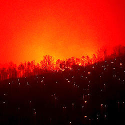
A fire burns along the ground in a ponderosa pine forest, New Mexico
Prescribed fires, such as this one, are used by land managers to restore ponderosa pine forests to more resilient conditions. We are fortunate to be able to occasionally participate in such burns because we are co-located with land managers.

Fire effects monitoring after the Funny River Fire, Kenai Peninsula AK
Pre- and post-fire measurements of fire effects help ecologists, fire scientists, and managers determine how the severity of wildfires affects plants, animal habitat, and ecosystem services
Pre- and post-fire measurements of fire effects help ecologists, fire scientists, and managers determine how the severity of wildfires affects plants, animal habitat, and ecosystem services

Wildfire and Alaskan Permafrost
Deploying geophysical equipment in the Nome Creek (AK) area to assess the effect of wildfire on permafrost. Small electrical signals are injected into the ground through metal stakes connected to the orange cable in the foreground. The measured response is used to detect belowground permafrost conditions.
Deploying geophysical equipment in the Nome Creek (AK) area to assess the effect of wildfire on permafrost. Small electrical signals are injected into the ground through metal stakes connected to the orange cable in the foreground. The measured response is used to detect belowground permafrost conditions.

Deploying fire instruments during a wildfire
Fire behavior instruments are deployed during wildfires and prescribed fires to provide data on the types of fire environments that damage archaeological resources
Fire behavior instruments are deployed during wildfires and prescribed fires to provide data on the types of fire environments that damage archaeological resources

Controlled fire studies provide data on archaeological sites impacts
Controlled experiments that simulate fire environments provide critical information for understanding how fire intensity and duration impact archaeological resources
Controlled experiments that simulate fire environments provide critical information for understanding how fire intensity and duration impact archaeological resources

Burned Trees after wildfire in Gila National Forest
Burned trees along the trail into Hummingbird Saddle, Gila National Forest, New Mexico, where USGS scientists installed a rain gage.
Burned trees along the trail into Hummingbird Saddle, Gila National Forest, New Mexico, where USGS scientists installed a rain gage.
Related Content
What should I know about wildfires and debris flows?
Wildland fires are inevitable in the western United States. Expansion of human development into forested areas has created a situation where wildfires can adversely affect lives and property, as can the flooding and landslides that occur in the aftermath of the fires. There is a need to develop tools and methods to identify and quantify the potential hazards posed by landslides produced from...
Will global warming produce more frequent and more intense wildfires?
There isn’t a direct relationship between climate change and fire, but researchers have found strong correlations between warm summer temperatures and large fire years, so there is general consensus that fire occurrence will increase with climate change. Hot, dry conditions, however, do not automatically mean fire—something needs to create the spark and actually start the fire. In some parts of...
A fire burns along the ground in a ponderosa pine forest, New Mexico
Prescribed fires, such as this one, are used by land managers to restore ponderosa pine forests to more resilient conditions. We are fortunate to be able to occasionally participate in such burns because we are co-located with land managers.
Prescribed fires, such as this one, are used by land managers to restore ponderosa pine forests to more resilient conditions. We are fortunate to be able to occasionally participate in such burns because we are co-located with land managers.
Fire effects monitoring after the Funny River Fire, Kenai Peninsula AK
Pre- and post-fire measurements of fire effects help ecologists, fire scientists, and managers determine how the severity of wildfires affects plants, animal habitat, and ecosystem services
Pre- and post-fire measurements of fire effects help ecologists, fire scientists, and managers determine how the severity of wildfires affects plants, animal habitat, and ecosystem services
Wildfire and Alaskan Permafrost
Deploying geophysical equipment in the Nome Creek (AK) area to assess the effect of wildfire on permafrost. Small electrical signals are injected into the ground through metal stakes connected to the orange cable in the foreground. The measured response is used to detect belowground permafrost conditions.
Deploying geophysical equipment in the Nome Creek (AK) area to assess the effect of wildfire on permafrost. Small electrical signals are injected into the ground through metal stakes connected to the orange cable in the foreground. The measured response is used to detect belowground permafrost conditions.
Deploying fire instruments during a wildfire
Fire behavior instruments are deployed during wildfires and prescribed fires to provide data on the types of fire environments that damage archaeological resources
Fire behavior instruments are deployed during wildfires and prescribed fires to provide data on the types of fire environments that damage archaeological resources
Controlled fire studies provide data on archaeological sites impacts
Controlled experiments that simulate fire environments provide critical information for understanding how fire intensity and duration impact archaeological resources
Controlled experiments that simulate fire environments provide critical information for understanding how fire intensity and duration impact archaeological resources
Burned Trees after wildfire in Gila National Forest
Burned trees along the trail into Hummingbird Saddle, Gila National Forest, New Mexico, where USGS scientists installed a rain gage.
Burned trees along the trail into Hummingbird Saddle, Gila National Forest, New Mexico, where USGS scientists installed a rain gage.