
America has questions about climate change, and the USGS has real answers. In this episode of Climate Connections, USGS scientists answer questions gathered from downtown Denver, Colorado. Questions include:
Why is climate change happening and what are the causes?
There are many “natural” and “anthropogenic” (human-induced) factors that contribute to climate change. Climate change has always happened on Earth, which is clearly seen in the geological record; it is the rapid rate and the magnitude of climate change occurring now that is of great concern worldwide. Greenhouse gases in the atmosphere absorb heat radiation. Human activity has increased greenhouse gases in the atmosphere since the Industrial Revolution, leading to more heat retention and an increase in surface temperatures. Atmospheric aerosols alter climate by scattering and absorbing solar and infrared radiation and they may also change the microphysical and chemical properties of clouds. Finally, land-use changes, such as deforestation have led to changes in the amount of sunlight reflected from the ground back into space (the surface albedo).
Related
What are the long-term effects of climate change? What are the long-term effects of climate change?
Scientists have predicted that long-term effects of climate change will include a decrease in sea ice and an increase in permafrost thawing, an increase in heat waves and heavy precipitation, and decreased water resources in semi-arid regions. Below are some of the regional impacts of global change forecast by the Intergovernmental Panel on Climate Change: North America: Decreasing snowpack in the...

What is the difference between weather and climate change? What is the difference between weather and climate change?
Weather refers to short term atmospheric conditions while climate is the weather of a specific region averaged over a long period of time. Climate change refers to long-term changes.

How can climate change affect natural disasters? How can climate change affect natural disasters?
With increasing global surface temperatures the possibility of more droughts and increased intensity of storms will likely occur. As more water vapor is evaporated into the atmosphere it becomes fuel for more powerful storms to develop. More heat in the atmosphere and warmer ocean surface temperatures can lead to increased wind speeds in tropical storms. Rising sea levels expose higher locations...

How do changes in climate and land use relate to one another? How do changes in climate and land use relate to one another?
The link between land use and the climate is complex. First, land cover--as shaped by land use practices--affects the global concentration of greenhouse gases. Second, while land use change is an important driver of climate change, a changing climate can lead to changes in land use and land cover. For example, farmers might shift from their customary crops to crops that will have higher economic...
How do we know the climate is changing? How do we know the climate is changing?
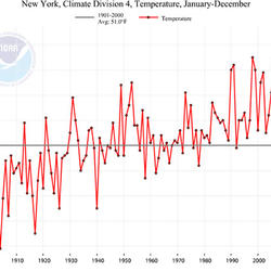
The scientific community is certain that the Earth's climate is changing because of the trends that we see in the instrumented climate record and the changes that have been observed in physical and biological systems. The instrumental record of climate change is derived from thousands of temperature and precipitation recording stations around the world. We have very high confidence in these...

What are some of the signs of climate change? What are some of the signs of climate change?
• Temperatures are rising world-wide due to greenhouse gases trapping more heat in the atmosphere. • Droughts are becoming longer and more extreme around the world. • Tropical storms becoming more severe due to warmer ocean water temperatures. • As temperatures rise there is less snowpack in mountain ranges and polar areas and the snow melts faster. • Overall, glaciers are melting at a faster rate...

Does the USGS monitor global warming? Does the USGS monitor global warming?
Not specifically. Our charge is to understand characteristics of the Earth, especially the Earth's surface, that affect our Nation's land, water, and biological resources. That includes quite a bit of environmental monitoring. Other agencies, especially NOAA and NASA, are specifically funded to monitor global temperature and atmospheric phenomena such as ozone concentrations. The work through...
Will global warming produce more frequent and more intense wildfires? Will global warming produce more frequent and more intense wildfires?
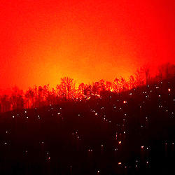
There isn’t a direct relationship between climate change and fire, but researchers have found strong correlations between warm summer temperatures and large fire years, so there is general consensus that fire occurrence will increase with climate change. Hot, dry conditions, however, do not automatically mean fire—something needs to create the spark and actually start the fire. In some parts of...
Has the USGS made any Biologic Carbon Sequestration assessments? Has the USGS made any Biologic Carbon Sequestration assessments?
The USGS is congressionally mandated (2007 Energy Independence and Security Act) to conduct a comprehensive national assessment of storage and flux (flow) of carbon and the fluxes of other greenhouse gases (including carbon dioxide) in ecosystems. At this writing, reports have been completed for Alaska, the Eastern U.S., the Great Plains, and the Western U.S. Learn more: Carbon Emissions and...

How does carbon get into the atmosphere? How does carbon get into the atmosphere?
Atmospheric carbon dioxide comes from two primary sources—natural and human activities. Natural sources of carbon dioxide include most animals, which exhale carbon dioxide as a waste product. Human activities that lead to carbon dioxide emissions come primarily from energy production, including burning coal, oil, or natural gas. Learn more: Sources of Greenhouse Gas Emissions (EPA)
How much carbon dioxide can the United States store via geologic sequestration? How much carbon dioxide can the United States store via geologic sequestration?
In 2013, the USGS released the first-ever comprehensive, nation-wide assessment of geologic carbon sequestration, which estimates a mean storage potential of 3,000 metric gigatons of carbon dioxide. The assessment is the first geologically-based, probabilistic assessment, with a range of 2,400 to 3,700 metric gigatons of potential carbon dioxide storage. In addition, the assessment is for the...
How much carbon dioxide does the United States and the World emit each year from energy sources? How much carbon dioxide does the United States and the World emit each year from energy sources?
The U.S. Energy Information Administration estimates that in 2019, the United States emitted 5,130 million metric tons of energy-related carbon dioxide, while the global emissions of energy-related carbon dioxide totaled 33,621.5 million metric tons.

USGS Climate Connections: Questions from Colorado
America has questions about climate change, and the USGS has real answers. In this episode of Climate Connections, USGS scientists answer questions gathered from downtown Denver, Colorado. Questions include:

Climate Connections: Questions from Washington, DC
Climate Connections: Questions from Washington, DCAmerica has questions about climate change, and the USGS has real answers. In this episode of Climate Connections, USGS scientists answer questions gathered from students at H.D. Woodson High School in Washington, DC. Questions include:
")
Climate Connections: Questions from Glacier National Park, MT (Ep 4)
Climate Connections: Questions from Glacier National Park, MT (Ep 4)America has questions about climate change, and the USGS has real answers. In this episode of Climate Connections, USGS scientists answer questions gathered from the beautiful Glacier National Park in Montana. Questions include:

Climate Connections: Questions from Puerto Rico
America has questions about climate change, and the USGS has real answers. In this episode of Climate Connections, USGS scientists answer questions gathered from Puerto Rico. Questions include:
- Why has the rainy season been so long in Puerto Rico?
- How is global warming impacting the island of Puerto Rico?

Climate Connections: Questions from North and South Carolina
Climate Connections: Questions from North and South CarolinaAmerica has questions about climate change, and the USGS has real answers. In this episode of Climate Connections, USGS scientists answer questions gathered from North and South Carolina.

USGS Public Lecture Series: Climate Change 101
Climate change is an issue of increasing public concern because of its potential effects on land, water, and biological resources.
Climate change is an issue of increasing public concern because of its potential effects on land, water, and biological resources.

USGS Public Lecture Series: Watching Nature's Clock: A Citizen-Scientist Effort to Track Seasonal Signs of Climate Change
USGS Public Lecture Series: Watching Nature's Clock: A Citizen-Scientist Effort to Track Seasonal Signs of Climate ChangeA new USGS program, the USA National Phenology Network, is recruiting tens of thousands of volunteers to team up with scientists to help track the effects of climate on seasonal patterns of plant and animal behavior.

Can We Move Carbon from the Atmosphere and into Rocks?
Can We Move Carbon from the Atmosphere and into Rocks?A new method to assess the Nation's potential for storing carbon dioxide in rocks below the earth's surface could help lessen climate change impacts. The injection and storage of liquid carbon dioxide into subsurface rocks is known as geologic carbon sequestration.
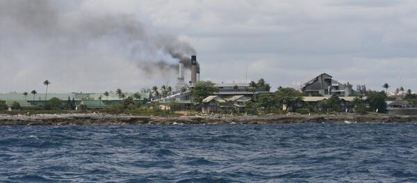
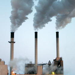
Smoke Stack - Air Pollution
An example of human activities that impact the earth's atmosphere.
An example of human activities that impact the earth's atmosphere.
Farming Carbon to Help the Atmosphere and the Land
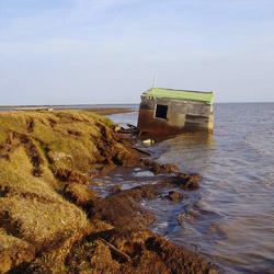
Farming Carbon to Help the Atmosphere and the LandLong-standing farming practices in California's Sacramento-San Joaquin River Delta expose fragile peat soils to wind, rain and cultivation, emit carbon dioxide (CO2) and cause land subsidence. To capture or contain the carbon, farmers would ‘grow’ wetlands.
Farming Carbon to Help the Atmosphere and the Land
Farming Carbon to Help the Atmosphere and the LandLong-standing farming practices in California's Sacramento-San Joaquin River Delta expose fragile peat soils to wind, rain and cultivation, emit carbon dioxide (CO2) and cause land subsidence. To capture or contain the carbon, farmers would ‘grow’ wetlands.
Related
What are the long-term effects of climate change? What are the long-term effects of climate change?
Scientists have predicted that long-term effects of climate change will include a decrease in sea ice and an increase in permafrost thawing, an increase in heat waves and heavy precipitation, and decreased water resources in semi-arid regions. Below are some of the regional impacts of global change forecast by the Intergovernmental Panel on Climate Change: North America: Decreasing snowpack in the...
What is the difference between weather and climate change? What is the difference between weather and climate change?
Weather refers to short term atmospheric conditions while climate is the weather of a specific region averaged over a long period of time. Climate change refers to long-term changes.
How can climate change affect natural disasters? How can climate change affect natural disasters?
With increasing global surface temperatures the possibility of more droughts and increased intensity of storms will likely occur. As more water vapor is evaporated into the atmosphere it becomes fuel for more powerful storms to develop. More heat in the atmosphere and warmer ocean surface temperatures can lead to increased wind speeds in tropical storms. Rising sea levels expose higher locations...
How do changes in climate and land use relate to one another? How do changes in climate and land use relate to one another?
The link between land use and the climate is complex. First, land cover--as shaped by land use practices--affects the global concentration of greenhouse gases. Second, while land use change is an important driver of climate change, a changing climate can lead to changes in land use and land cover. For example, farmers might shift from their customary crops to crops that will have higher economic...
How do we know the climate is changing? How do we know the climate is changing?
The scientific community is certain that the Earth's climate is changing because of the trends that we see in the instrumented climate record and the changes that have been observed in physical and biological systems. The instrumental record of climate change is derived from thousands of temperature and precipitation recording stations around the world. We have very high confidence in these...
What are some of the signs of climate change? What are some of the signs of climate change?
• Temperatures are rising world-wide due to greenhouse gases trapping more heat in the atmosphere. • Droughts are becoming longer and more extreme around the world. • Tropical storms becoming more severe due to warmer ocean water temperatures. • As temperatures rise there is less snowpack in mountain ranges and polar areas and the snow melts faster. • Overall, glaciers are melting at a faster rate...
Does the USGS monitor global warming? Does the USGS monitor global warming?
Not specifically. Our charge is to understand characteristics of the Earth, especially the Earth's surface, that affect our Nation's land, water, and biological resources. That includes quite a bit of environmental monitoring. Other agencies, especially NOAA and NASA, are specifically funded to monitor global temperature and atmospheric phenomena such as ozone concentrations. The work through...
Will global warming produce more frequent and more intense wildfires? Will global warming produce more frequent and more intense wildfires?
There isn’t a direct relationship between climate change and fire, but researchers have found strong correlations between warm summer temperatures and large fire years, so there is general consensus that fire occurrence will increase with climate change. Hot, dry conditions, however, do not automatically mean fire—something needs to create the spark and actually start the fire. In some parts of...
Has the USGS made any Biologic Carbon Sequestration assessments? Has the USGS made any Biologic Carbon Sequestration assessments?
The USGS is congressionally mandated (2007 Energy Independence and Security Act) to conduct a comprehensive national assessment of storage and flux (flow) of carbon and the fluxes of other greenhouse gases (including carbon dioxide) in ecosystems. At this writing, reports have been completed for Alaska, the Eastern U.S., the Great Plains, and the Western U.S. Learn more: Carbon Emissions and...
How does carbon get into the atmosphere? How does carbon get into the atmosphere?
Atmospheric carbon dioxide comes from two primary sources—natural and human activities. Natural sources of carbon dioxide include most animals, which exhale carbon dioxide as a waste product. Human activities that lead to carbon dioxide emissions come primarily from energy production, including burning coal, oil, or natural gas. Learn more: Sources of Greenhouse Gas Emissions (EPA)
How much carbon dioxide can the United States store via geologic sequestration? How much carbon dioxide can the United States store via geologic sequestration?
In 2013, the USGS released the first-ever comprehensive, nation-wide assessment of geologic carbon sequestration, which estimates a mean storage potential of 3,000 metric gigatons of carbon dioxide. The assessment is the first geologically-based, probabilistic assessment, with a range of 2,400 to 3,700 metric gigatons of potential carbon dioxide storage. In addition, the assessment is for the...
How much carbon dioxide does the United States and the World emit each year from energy sources? How much carbon dioxide does the United States and the World emit each year from energy sources?
The U.S. Energy Information Administration estimates that in 2019, the United States emitted 5,130 million metric tons of energy-related carbon dioxide, while the global emissions of energy-related carbon dioxide totaled 33,621.5 million metric tons.
USGS Climate Connections: Questions from Colorado
America has questions about climate change, and the USGS has real answers. In this episode of Climate Connections, USGS scientists answer questions gathered from downtown Denver, Colorado. Questions include:
America has questions about climate change, and the USGS has real answers. In this episode of Climate Connections, USGS scientists answer questions gathered from downtown Denver, Colorado. Questions include:
Climate Connections: Questions from Washington, DC
Climate Connections: Questions from Washington, DCAmerica has questions about climate change, and the USGS has real answers. In this episode of Climate Connections, USGS scientists answer questions gathered from students at H.D. Woodson High School in Washington, DC. Questions include:
Climate Connections: Questions from Glacier National Park, MT (Ep 4)
Climate Connections: Questions from Glacier National Park, MT (Ep 4)America has questions about climate change, and the USGS has real answers. In this episode of Climate Connections, USGS scientists answer questions gathered from the beautiful Glacier National Park in Montana. Questions include:
Climate Connections: Questions from Puerto Rico
America has questions about climate change, and the USGS has real answers. In this episode of Climate Connections, USGS scientists answer questions gathered from Puerto Rico. Questions include:
- Why has the rainy season been so long in Puerto Rico?
- How is global warming impacting the island of Puerto Rico?
America has questions about climate change, and the USGS has real answers. In this episode of Climate Connections, USGS scientists answer questions gathered from Puerto Rico. Questions include:
- Why has the rainy season been so long in Puerto Rico?
- How is global warming impacting the island of Puerto Rico?
Climate Connections: Questions from North and South Carolina
Climate Connections: Questions from North and South CarolinaAmerica has questions about climate change, and the USGS has real answers. In this episode of Climate Connections, USGS scientists answer questions gathered from North and South Carolina.
USGS Public Lecture Series: Climate Change 101
Climate change is an issue of increasing public concern because of its potential effects on land, water, and biological resources.
Climate change is an issue of increasing public concern because of its potential effects on land, water, and biological resources.
USGS Public Lecture Series: Watching Nature's Clock: A Citizen-Scientist Effort to Track Seasonal Signs of Climate Change
USGS Public Lecture Series: Watching Nature's Clock: A Citizen-Scientist Effort to Track Seasonal Signs of Climate ChangeA new USGS program, the USA National Phenology Network, is recruiting tens of thousands of volunteers to team up with scientists to help track the effects of climate on seasonal patterns of plant and animal behavior.
Can We Move Carbon from the Atmosphere and into Rocks?
Can We Move Carbon from the Atmosphere and into Rocks?A new method to assess the Nation's potential for storing carbon dioxide in rocks below the earth's surface could help lessen climate change impacts. The injection and storage of liquid carbon dioxide into subsurface rocks is known as geologic carbon sequestration.
Smoke Stack - Air Pollution
An example of human activities that impact the earth's atmosphere.
An example of human activities that impact the earth's atmosphere.
Farming Carbon to Help the Atmosphere and the Land
Farming Carbon to Help the Atmosphere and the LandLong-standing farming practices in California's Sacramento-San Joaquin River Delta expose fragile peat soils to wind, rain and cultivation, emit carbon dioxide (CO2) and cause land subsidence. To capture or contain the carbon, farmers would ‘grow’ wetlands.
Updated Date: June 18, 2025