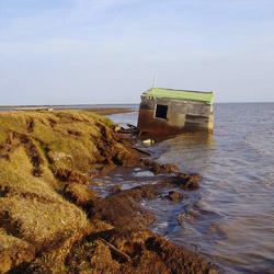
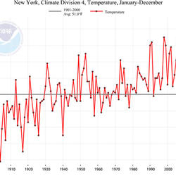
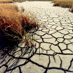
The link between land use and the climate is complex. First, land cover--as shaped by land use practices--affects the global concentration of greenhouse gases. Second, while land use change is an important driver of climate change, a changing climate can lead to changes in land use and land cover. For example, farmers might shift from their customary crops to crops that will have higher economic return under changing climatic conditions. Higher temperatures affect mountain snowpack and vegetation cover as well as water needed for irrigation. The understanding of the interactions between climate and land use change is improving but continued scientific investigation is needed.
Related Content
Does an increase in the 100-year flood estimate originate from climate or land-use change?
Climate variability (dry cycles to wet cycles) and land-use change play a significant role, but there is a large amount of uncertainty around the flood quantile estimates (the value of discharge corresponding to the 100-year flood), particularly if there isn’t a long record of observed data at a stream location. Learn more: The 100-Year Flood The 100-Year Flood--It's All About Chance
What are the long-term effects of climate change?
Scientists have predicted that long-term effects of climate change will include a decrease in sea ice and an increase in permafrost thawing, an increase in heat waves and heavy precipitation, and decreased water resources in semi-arid regions. Below are some of the regional impacts of global change forecast by the Intergovernmental Panel on Climate Change: North America: Decreasing snowpack in the...
What is the difference between weather and climate change?
Weather refers to short term atmospheric conditions while climate is the weather of a specific region averaged over a long period of time. Climate change refers to long-term changes.
How can climate change affect natural disasters?
With increasing global surface temperatures the possibility of more droughts and increased intensity of storms will likely occur. As more water vapor is evaporated into the atmosphere it becomes fuel for more powerful storms to develop. More heat in the atmosphere and warmer ocean surface temperatures can lead to increased wind speeds in tropical storms. Rising sea levels expose higher locations...
How do we know the climate is changing?
The scientific community is certain that the Earth's climate is changing because of the trends that we see in the instrumented climate record and the changes that have been observed in physical and biological systems. The instrumental record of climate change is derived from thousands of temperature and precipitation recording stations around the world. We have very high confidence in these...
What are some of the signs of climate change?
• Temperatures are rising world-wide due to greenhouse gases trapping more heat in the atmosphere.• Droughts are becoming longer and more extreme around the world.• Tropical storms becoming more severe due to warmer ocean water temperatures.• As temperatures rise there is less snowpack in mountain ranges and polar areas and the snow melts faster.• Overall, glaciers are melting at a faster rate.•...
What is the difference between global warming and climate change?
Although people tend to use these terms interchangeably, global warming is just one aspect of climate change. “Global warming” refers to the rise in global temperatures due mainly to the increasing concentrations of greenhouse gases in the atmosphere. “Climate change” refers to the increasing changes in the measures of climate over a long period of time – including precipitation, temperature, and...
Why is climate change happening and what are the causes?
There are many “natural” and “anthropogenic” (human-induced) factors that contribute to climate change. Climate change has always happened on Earth, which is clearly seen in the geological record; it is the rapid rate and the magnitude of climate change occurring now that is of great concern worldwide. Greenhouse gases in the atmosphere absorb heat radiation. Human activity has increased...
Monitoring and assessing urban heat island variations and effects in the United States
Using information from global climate models to inform policymaking—The role of the U.S. Geological Survey
Simulation of water availability in the Southeastern United States for historical and potential future climate and land-cover conditions
A record of change - Science and elder observations on the Navajo Nation
Ecosystem vulnerability to climate change in the southeastern United States
Climate Change Science Activities of the U.S. Geological Survey in New England
Desert wetlands—Archives of a wetter past
USGS Arctic Science Strategy
Climate change: evaluating your local and regional water resources
Remote sensing of land surface phenology
Delivering climate science about the Nation's fish, wildlife, and ecosystems: the U.S. Geological Survey National Climate Change and Wildlife Science Center
U.S. Geological Survey Climate and Land Use Change Science Strategy—A Framework for Understanding and Responding to Global Change
Related Content
- FAQ
Does an increase in the 100-year flood estimate originate from climate or land-use change?
Climate variability (dry cycles to wet cycles) and land-use change play a significant role, but there is a large amount of uncertainty around the flood quantile estimates (the value of discharge corresponding to the 100-year flood), particularly if there isn’t a long record of observed data at a stream location. Learn more: The 100-Year Flood The 100-Year Flood--It's All About Chance
What are the long-term effects of climate change?
Scientists have predicted that long-term effects of climate change will include a decrease in sea ice and an increase in permafrost thawing, an increase in heat waves and heavy precipitation, and decreased water resources in semi-arid regions. Below are some of the regional impacts of global change forecast by the Intergovernmental Panel on Climate Change: North America: Decreasing snowpack in the...
What is the difference between weather and climate change?
Weather refers to short term atmospheric conditions while climate is the weather of a specific region averaged over a long period of time. Climate change refers to long-term changes.
How can climate change affect natural disasters?
With increasing global surface temperatures the possibility of more droughts and increased intensity of storms will likely occur. As more water vapor is evaporated into the atmosphere it becomes fuel for more powerful storms to develop. More heat in the atmosphere and warmer ocean surface temperatures can lead to increased wind speeds in tropical storms. Rising sea levels expose higher locations...
How do we know the climate is changing?
The scientific community is certain that the Earth's climate is changing because of the trends that we see in the instrumented climate record and the changes that have been observed in physical and biological systems. The instrumental record of climate change is derived from thousands of temperature and precipitation recording stations around the world. We have very high confidence in these...
What are some of the signs of climate change?
• Temperatures are rising world-wide due to greenhouse gases trapping more heat in the atmosphere.• Droughts are becoming longer and more extreme around the world.• Tropical storms becoming more severe due to warmer ocean water temperatures.• As temperatures rise there is less snowpack in mountain ranges and polar areas and the snow melts faster.• Overall, glaciers are melting at a faster rate.•...
What is the difference between global warming and climate change?
Although people tend to use these terms interchangeably, global warming is just one aspect of climate change. “Global warming” refers to the rise in global temperatures due mainly to the increasing concentrations of greenhouse gases in the atmosphere. “Climate change” refers to the increasing changes in the measures of climate over a long period of time – including precipitation, temperature, and...
Why is climate change happening and what are the causes?
There are many “natural” and “anthropogenic” (human-induced) factors that contribute to climate change. Climate change has always happened on Earth, which is clearly seen in the geological record; it is the rapid rate and the magnitude of climate change occurring now that is of great concern worldwide. Greenhouse gases in the atmosphere absorb heat radiation. Human activity has increased...
- Multimedia
- Publications
Filter Total Items: 18
Monitoring and assessing urban heat island variations and effects in the United States
Landsat surface temperature and land cover products have been used to estimate surface temperatures in urban and surrounding nonurban areas and to quantify urban heat island intensity. Understanding the intensity and long-term temporal trends of urban heat islands enables the heat-related health challenges associated with heat waves to be monitored and the effects for human health and ecosystems tAuthorsGeorge XianUsing information from global climate models to inform policymaking—The role of the U.S. Geological Survey
This report provides an overview of model-based climate science in a risk management context. In addition, it summarizes how the U.S. Geological Survey (USGS) will continue to follow best scientific practices and when and how the results of this research will be delivered to the U.S. Department of the Interior (DOI) and other stakeholders to inform policymaking. Climate change is a risk managementAuthorsAdam Terando, David Reidmiller, Steven W. Hostetler, Jeremy S. Littell, T. Douglas Beard, Sarah R. Weiskopf, Jayne Belnap, Geoffrey S. PlumleeSimulation of water availability in the Southeastern United States for historical and potential future climate and land-cover conditions
A study was conducted by the U.S. Geological Survey (USGS), in cooperation with the Gulf Coastal Plains and Ozarks Landscape Conservation Cooperative (GCPO LCC) and the Department of the Interior Southeast Climate Adaptation Science Center, to evaluate the hydrologic response of a daily time step hydrologic model to historical observations and projections of potential climate and land-cover changeAuthorsJacob H. LaFontaine, Rheannon M. Hart, Lauren E. Hay, William H. Farmer, Andy R. Bock, Roland J. Viger, Steven L. Markstrom, R. Steve Regan, Jessica M. DriscollA record of change - Science and elder observations on the Navajo Nation
A Record of Change - Science and Elder Observations on the Navajo Nation is a 25-minute documentary about combining observations from Navajo elders with conventional science to determine how tribal lands and culture are affected by climate change. On the Navajo Nation, there is a shortage of historical climate data, making it difficult to assess changing environmental conditions.This video revealsAuthorsMargaret M. Hiza-Redsteer, Stephen M. WessellsEcosystem vulnerability to climate change in the southeastern United States
Two recent investigations of climate-change vulnerability for 19 terrestrial, aquatic, riparian, and coastal ecosystems of the southeastern United States have identified a number of important considerations, including potential for changes in hydrology, disturbance regimes, and interspecies interactions. Complementary approaches using geospatial analysis and literature synthesis integrated informaAuthorsJennifer M. Cartwright, Jennifer CostanzaClimate Change Science Activities of the U.S. Geological Survey in New England
The U.S. Geological Survey (USGS) has actively pursued research in the effects of climate change on the hydrology of New England. Ongoing focus areas of climate change science activities of the USGS in New England include the following: • Hydrologic climate-response data (initiating or expanding long-term hydrologic climate-response data collection networks to detect and monitor climate-related chAuthorsRobert M. LentDesert wetlands—Archives of a wetter past
Scientists from the U.S. Geological Survey (USGS) are finding evidence of a much wetter past in the deserts of the American Southwest using a most unlikely source—wetlands. Wetlands form in arid environments where water tables approach or breach the ground surface. Often thought of as stagnant and unchanging, new evidence suggests that springs and wetlands responded dynamically to past episodes ofAuthorsJeffery S. Pigati, Kathleen B. Springer, Craig R. MankerUSGS Arctic Science Strategy
The United States is one of eight Arctic nations responsible for the stewardship of a polar region undergoing dramatic environmental, social, and economic changes. Although warming and cooling cycles have occurred over millennia in the Arctic region, the current warming trend is unlike anything recorded previously and is affecting the region faster than any other place on Earth, bringing dramaticAuthorsMark Shasby, Durelle SmithClimate change: evaluating your local and regional water resources
The BCM is a fine-scale hydrologic model that uses detailed maps of soils, geology, topography, and transient monthly or daily maps of potential evapotranspiration, air temperature, and precipitation to generate maps of recharge, runoff, snow pack, actual evapotranspiration, and climatic water deficit. With these comprehensive environmental inputs and experienced scientific analysis, the BCM proviAuthorsLorraine E. Flint, Alan L. Flint, James H. ThorneRemote sensing of land surface phenology
Remote sensing of land-surface phenology is an important method for studying the patterns of plant and animal growth cycles. Phenological events are sensitive to climate variation; therefore phenology data provide important baseline information documenting trends in ecology and detecting the impacts of climate change on multiple scales. The USGS Remote sensing of land surface phenology program proAuthorsG.A. Meier, Jesslyn F. BrownDelivering climate science about the Nation's fish, wildlife, and ecosystems: the U.S. Geological Survey National Climate Change and Wildlife Science Center
Changes to the Earth’s climate—temperature, precipitation, and other climate variables—pose significant challenges to our Nation’s natural resources. Managers of land, water, and living resources require an understanding of the impacts of climate change—which exacerbate ongoing stresses such as habitat alteration and invasive species—in order to design effective response strategies. In 2008, CongrAuthorsElda Varela-AcevedoU.S. Geological Survey Climate and Land Use Change Science Strategy—A Framework for Understanding and Responding to Global Change
Executive SummaryThe U.S. Geological Survey (USGS), a nonregulatory Federal science agency with national scope and responsibilities, is uniquely positioned to serve the Nation’s needs in understanding and responding to global change, including changes in climate, water availability, sea level, land use and land cover, ecosystems, and global biogeochemical cycles. Global change is among the most chAuthorsVirginia R. Burkett, David A. Kirtland, Ione L. Taylor, Jayne Belnap, Thomas M. Cronin, Michael D. Dettinger, Eldrich L. Frazier, John W. Haines, Thomas R. Loveland, Paul C.D. Milly, Robin O'Malley, Robert S. Thompson, Alec G. Maule, Gerard McMahon, Robert G. Striegl - News