
Volcano Science Center
Find U.S. Volcano
The Volcano Science Center is the primary center serving the mission of the USGS Volcano Hazards Program — to enhance public safety and minimize social and economic disruption from volcanic unrest and eruption. The center is home to the five US volcano observatories with offices in Anchorage, Alaska; Menlo Park and Mountain View, California; Vancouver, Washington; and Hilo, Hawaii.


News
The top Yellowstone geological stories of 2025
The top Yellowstone geological stories of 2025
Volcano Watch — Hau’oli Makahiki Hou: a round-up of fireworks from Kīlauea’s fountains
Volcano Watch — Hau’oli Makahiki Hou: a round-up of fireworks from Kīlauea’s fountains
Idaho’s forgotten eruptions—the Challis volcanics
Idaho’s forgotten eruptions—the Challis volcanics
Publications
The anatomy and lethality of the Siberian Traps large igneous province The anatomy and lethality of the Siberian Traps large igneous province
Emplacement of the Siberian Traps large igneous province (LIP) around 252 Ma coincided with the most profound environmental disruption of the past 500 million years. The enormous volume of the Siberian Traps, its ability to generate greenhouse gases and other volatiles, and a temporal coincidence with extinction all suggest a causal link. Patterns of marine and terrestrial extinction...
Mitigation of human cognitive bias in volcanic eruption forecasting Mitigation of human cognitive bias in volcanic eruption forecasting
Modern operational eruption forecasting methods rely heavily on human judgment in the face of uncertainty and are thus susceptible to myriad cognitive biases and errors by the scientist-forecasters. Recent developments in the behavioral sciences have elucidated cognitive biases across a wide spectrum of human behaviors and found ways to mitigate them. These insights have led to...
The transition from melt accumulation to eruption initiation recorded by orthopyroxene Fe-Mg diffusion timescales in late Holocene rhyolites, South Sister volcano, Oregon Cascade Range The transition from melt accumulation to eruption initiation recorded by orthopyroxene Fe-Mg diffusion timescales in late Holocene rhyolites, South Sister volcano, Oregon Cascade Range
South Sister volcano, Oregon Cascade Range, USA, has repeatedly erupted rhyolite since ca. 40 ka. The youngest such eruptions are the ca. 2 ka Rock Mesa and Devils Chain rhyolites, erupted several hundred years apart from two multi-vent complexes separated by 3–6 km. Fe-Mg interdiffusion models of orthopyroxene rims from both rhyolites produce timescales up to several-thousand years, but
Science
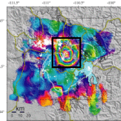
Uplift along the north rim of Yellowstone Caldera
An area on the north rim of Yellowstone caldera, to the south of Norris Geyser Basin, started to uplift slightly in July 2025. Similar deformation occurred in the same area during 1996-2004 and reveals characteristics of the subsurface.
USGS volcano-hydrothermal fluid chemistry data
The USGS has published chemistry data for volcanic and hydrothermal fluids sampled at sites around the United States.

How are lava flows mapped in Hawaii?
Lava flow mapping provides situational awareness of volcanic eruptive hazards in Hawaii. During eruptions, USGS Hawaiian Volcano Observatory (HVO) scientists employ a variety of techniques to collect and disseminate map data depicting key eruptive features, especially lava flows.