
The New England Water Science Center's Connecticut office has a spacious three-door garage.
Images
Images below come from a wide variety of USGS science activities in the Northeast Region. Science Center staff showcase what we do, who we are, and where we work conducting science that inform decision makers and addresses societal needs.
Filter Total Items: 2011

Connecticut Office Garage
The New England Water Science Center's Connecticut office has a spacious three-door garage.

New England Water Science Center Connecticut Office
New England Water Science Center Connecticut OfficeThe New England Water Science Center Connecticut Office is located on the campus of Goodwin University at 339 Main Street in East Hartford.
New England Water Science Center Connecticut Office
New England Water Science Center Connecticut OfficeThe New England Water Science Center Connecticut Office is located on the campus of Goodwin University at 339 Main Street in East Hartford.

Neponset River in Canton, Massachusetts
A view of the Neponset River in Canton, Massachusetts, near a 01105554 USGS streamgage at Greenlodge Street.
A view of the Neponset River in Canton, Massachusetts, near a 01105554 USGS streamgage at Greenlodge Street.

Hydrologic Technician collecting a water quality sample at Moose River in Victory, VT
Hydrologic Technician collecting a water quality sample at Moose River in Victory, VTHydrologic Technician Brendan Crowley collecting a water quality sample at Moose River in Victory, VT (01134500). This site is sampled monthly for the Upper Connecticut River Watershed project.

Andrew Kowalczk entering the Oneida River to conduct annual servicing to an Index Velocity gage
Andrew Kowalczk entering the Oneida River to conduct annual servicing to an Index Velocity gageAndrew Kowalczk, a NYWSC scientific diver, entering the Oneida River to conduct annual servicing to an Index Velocity gage. The NYWSC divers service various gages across the state to ensure data collected is as accurate as possible for the cooperators and public.
Fall 2023 Photo Contest Winner: Zachary Heck, People category

Micah Kieffer holds a shortnose sturgeon
Fish Biologist Micah Kieffer holds a shortnose sturgeon during a public outreach event at EESC's S.O. Conte Research Lab in Turners Falls, MA.
Fish Biologist Micah Kieffer holds a shortnose sturgeon during a public outreach event at EESC's S.O. Conte Research Lab in Turners Falls, MA.

David Walters measuring surface elevation table that is used to assess changes in wetland surface (accretion and/or erosion).
David Walters measuring surface elevation table that is used to assess changes in wetland surface (accretion and/or erosion).David Walters measuring surface elevation table that is used to assess changes in wetland surface (accretion and/or erosion) at Money Stump in Blackwater National Wildlife Refuge in Cambridge, Maryland.
Winter 2024 Photo Contest: Melinda Martinez, Honorable Mention category

USGS Scientists and Survey Technicians deploying geophysical survey systems on the R/V Pelican in the Gulf of Mexico
USGS Scientists and Survey Technicians deploying geophysical survey systems on the R/V Pelican in the Gulf of MexicoUSGS Scientists and Survey Technicians from the Woods Hole Coastal and Marine Science Center (Laura Brothers, Dave Foster, Pat Berube and Chuck Worley) deploying geophysical survey systems on the R/V Pelican in the Gulf of Mexico.
Fall 2023 Photo Contest Winner: Seth Ackerman, Honorable Mention category

Brandon Graham collecting a sample from a sediment exposure at Army Base Fort Drum, New York
Brandon Graham collecting a sample from a sediment exposure at Army Base Fort Drum, New YorkBrandon Graham collecting a sample from a sediment exposure at Army Base Fort Drum, New York. These samples were collected as part of an OSL (optically-stimulated luminescence) dating campaign in collaboration with Shannon Mahan of the USGS Luminescence Lab in Denver, CO.
Fall 2023 Photo Contest Winner: Grant Colip, USGS at Work category

Screenshot of opening page for geonarrative "Hurricane Ida: U.S. Geological Survey Response in Pennsylvania to September 1-2, 2021, Flooding Related to Remnants of Hurricane Ida "
Screenshot of opening page for geonarrative "Hurricane Ida: U.S. Geological Survey Response in Pennsylvania to September 1-2, 2021, Flooding Related to Remnants of Hurricane Ida "Screenshot of title page for "Hurricane Ida: USGS Response in Pennsylvania to September 1-2, 2021, Flooding Related to Remnants of Hurricane Ida" geonarrative.
Screenshot of opening page for geonarrative "Hurricane Ida: U.S. Geological Survey Response in Pennsylvania to September 1-2, 2021, Flooding Related to Remnants of Hurricane Ida "
Screenshot of opening page for geonarrative "Hurricane Ida: U.S. Geological Survey Response in Pennsylvania to September 1-2, 2021, Flooding Related to Remnants of Hurricane Ida "Screenshot of opening page for geonarrative "Hurricane Ida: U.S. Geological Survey Response in Pennsylvania to September 1-2, 2021, Flooding Related to Remnants of Hurricane Ida "
Screenshot of opening page for geonarrative "Hurricane Ida: U.S. Geological Survey Response in Pennsylvania to September 1-2, 2021, Flooding Related to Remnants of Hurricane Ida "Screenshot of title page for "Hurricane Ida: USGS Response in Pennsylvania to September 1-2, 2021, Flooding Related to Remnants of Hurricane Ida" geonarrative.
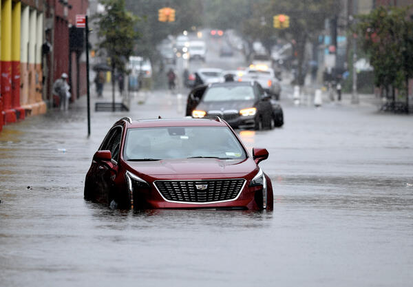
Abandoned cars on a flooded street in Brooklyn, NY.
Abandoned cars on a flooded street in Brooklyn, NY.Abandoned cars on a flooded street in the Gowanus neighborhood of Brooklyn, NY during a storm in 2023.
Abandoned cars on a flooded street in Brooklyn, NY.
Abandoned cars on a flooded street in Brooklyn, NY.Abandoned cars on a flooded street in the Gowanus neighborhood of Brooklyn, NY during a storm in 2023.

Hydrologic Technician Documenting a High-Water Mark in Montpelier
Hydrologic Technician Documenting a High-Water Mark in MontpelierUSGS staff documenting a high-water mark in Montpelier, Vermont, after significant flooding.
Hydrologic Technician Documenting a High-Water Mark in Montpelier
Hydrologic Technician Documenting a High-Water Mark in MontpelierUSGS staff documenting a high-water mark in Montpelier, Vermont, after significant flooding.

Calibrating a continuous water quality monitor
New England WSC scientist calibrating a continuous water quality monitor at 410606073245700, Norwalk River at the Norwalk Aquarium.
New England WSC scientist calibrating a continuous water quality monitor at 410606073245700, Norwalk River at the Norwalk Aquarium.

Ryan Bottorff servicing a continuous water quality monitor at US Coast Guard Academy on the Thames River in Groton, CT
Ryan Bottorff servicing a continuous water quality monitor at US Coast Guard Academy on the Thames River in Groton, CTRyan Bottorff servicing a continuous water quality monitor at US Coast Guard Academy on the Thames River in Groton, CT.

New England Water Science Center Massachusetts/Rhode Island Office
New England Water Science Center Massachusetts/Rhode Island OfficeThe USGS New England Water Science Massachusetts/Rhode Island Office is located in Northborough, MA.
New England Water Science Center Massachusetts/Rhode Island Office
New England Water Science Center Massachusetts/Rhode Island OfficeThe USGS New England Water Science Massachusetts/Rhode Island Office is located in Northborough, MA.

Flood Damage of Cobble Ridge Road Bridge over West River in Londonderry, Vermont
Flood Damage of Cobble Ridge Road Bridge over West River in Londonderry, VermontA USGS hydrologist stands in front of debris and damage of Cobble Ridge Road Bridge over the West River in Londonderry, Vermont. This destruction occurred from flood waters that rose from a heavy-rainfall event in July 2023.

Groundwater Well at Hanscom Air Force Base
A groundwater well in a grassy field near Hanscom Air Force Base in Bedford, Massachusetts.
A groundwater well in a grassy field near Hanscom Air Force Base in Bedford, Massachusetts.

Hanscom Air Force Base
The peripheral fence of Hanscom Air Force base that is located downstream from the USGS streamgage on Shawsheen River at Hanscom Field in Bedford, Massachusetts.
The peripheral fence of Hanscom Air Force base that is located downstream from the USGS streamgage on Shawsheen River at Hanscom Field in Bedford, Massachusetts.

Installing High-Water Mark on a Building
A USGS hydrologic technician points to a high-water mark he just installed on the side of a building in Barre, Vermont after flooding in July 2023. The mudline on the exterior of the building indicates how high the flood waters rose, and the high-water mark is a data reference USGS supplies to Federal Emergency Management Agency (FEMA).
A USGS hydrologic technician points to a high-water mark he just installed on the side of a building in Barre, Vermont after flooding in July 2023. The mudline on the exterior of the building indicates how high the flood waters rose, and the high-water mark is a data reference USGS supplies to Federal Emergency Management Agency (FEMA).

High-Water Mark Attached to the Tree
A USGS hydrologic technician points to a high-water mark attached to the tree indicative of the height of the flood waters following a flash flood event in July 2023. This location was near the Dog River in Berlin, Vermont.
A USGS hydrologic technician points to a high-water mark attached to the tree indicative of the height of the flood waters following a flash flood event in July 2023. This location was near the Dog River in Berlin, Vermont.

High-Water Mark at a Damaged Road in Weston, Vermont
High-Water Mark at a Damaged Road in Weston, VermontA hydrologic technician points to a high-water mark on the building of Weston Town Offices days after a significant flood event, which damaged the adjacent road.
High-Water Mark at a Damaged Road in Weston, Vermont
High-Water Mark at a Damaged Road in Weston, VermontA hydrologic technician points to a high-water mark on the building of Weston Town Offices days after a significant flood event, which damaged the adjacent road.