
Thousands of young Atlantic salmon are being released into Salmon River in an effort to restore this diminished Lake Ontario fish population, extending the sport fishing season by at least two months in Oswego County, N.Y.
Images
See our science through the images below.
Filter Total Items: 3533

Salmon Are Carefully Released Using Buckets
Thousands of young Atlantic salmon are being released into Salmon River in an effort to restore this diminished Lake Ontario fish population, extending the sport fishing season by at least two months in Oswego County, N.Y.

Young Atlantic Salmon Reared at the USGS Tunison Lab in Cortland, N.Y.
Young Atlantic Salmon Reared at the USGS Tunison Lab in Cortland, N.Y.Thousands of young Atlantic salmon are being released into Salmon River in an effort to restore this diminished Lake Ontario fish population, extending the sport fishing season by at least two months in Oswego County, N.Y.

A Rainbow Trout Rests Among Substrate in Panther Creek
A Rainbow Trout Rests Among Substrate in Panther CreekA rainbow trout rests among substrate in Panther Creek upstream of Big Deer Creek, central Idaho. Panther Creek was severely damaged by heavy metals released from mining and milling activities at the former Blackbird Mine. USGS and other scientists compiled a 30-year record of recovery of the stream’s fish and macroinvertebrate populations.

Panther Creek Upstream of Big Deer Creek, central Idaho
Panther Creek Upstream of Big Deer Creek, central IdahoPanther Creek was severely damaged by heavy metals released from mining and milling activities at the former Blackbird Mine. USGS and other scientists compiled a 30-year record of recovery of the stream’s fish and macroinvertebrate populations.

A Rainbow Trout Rests Among Cobble Substrate in Panther Creek
A Rainbow Trout Rests Among Cobble Substrate in Panther CreekA rainbow trout rests among cobble substrate in Panther Creek downstream of Big Deer Creek, central Idaho. Panther Creek was severely damaged by heavy metals released from mining and milling activities at the former Blackbird Mine, and water quality in this section of the stream was acutely lethal to fish as late as 1985.

Green frog USGS photo by Mark Roth.jpg
A green frog blends in well in a grassy wetland. ARMI photo by Mark Roth. Northern Highland-American Legion State Forest, Wisconsin
A green frog blends in well in a grassy wetland. ARMI photo by Mark Roth. Northern Highland-American Legion State Forest, Wisconsin

Auwahi Reforestation Area, Maui
View of trees in the Auwahi reforestation area with glimpses of the invasive grassland in the distance.
View of trees in the Auwahi reforestation area with glimpses of the invasive grassland in the distance.

Auwahi Reforestation Area, Maui
View of the Auwahi reforestation area fence line with native species on the left and invasive grassland on the right.
View of the Auwahi reforestation area fence line with native species on the left and invasive grassland on the right.

Lamprey
River lamprey (L. Ayresii) ammoceote tail pattern.
River lamprey (L. Ayresii) ammoceote tail pattern.

Agassiz's Desert Tortoise
An Agassiz's desert tortoise hides in a burrow; a radio transmitter is attached to its shell as part of a USGS study.
An Agassiz's desert tortoise hides in a burrow; a radio transmitter is attached to its shell as part of a USGS study.
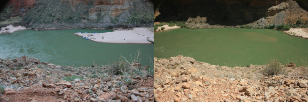
Same sandbar in 2008 and in 2011 in the Colorado River, Grand Canyon
Same sandbar in 2008 and in 2011 in the Colorado River, Grand CanyonPhotograph of sandbar about 45 miles downstream from Lees Ferry, Arizona showing river party camping on large sandbar deposited by the 2008 high-flow experiment (left) and again in August 2011 (right) when the size of the sandbar and campsite was much smaller. USGS photos, public domain.

River Lamprey
Eyed juvenile river lamprey (Lampetra ayresii) caught in Skagit River smolt trap, 2011.
Eyed juvenile river lamprey (Lampetra ayresii) caught in Skagit River smolt trap, 2011.

Black-and-White Larval Sturgeon
Collected in the Lower Missouri River on May 20, 2011, near Arrow Rock, Missouri, this larval sturgeon is estimated to be one day old.
Collected in the Lower Missouri River on May 20, 2011, near Arrow Rock, Missouri, this larval sturgeon is estimated to be one day old.

Fish Eggs in Organic Debris
Ten minutes of larval sampling in the Missouri River on May 24, 2011, resulted in this mass of organic debris and fish eggs.
Ten minutes of larval sampling in the Missouri River on May 24, 2011, resulted in this mass of organic debris and fish eggs.

Fairy Shrimp
A rare occurrence in the Missouri River, this Branchiopod known as a fairy shrimp was caught during larval sampling efforts near Arrow Rock, MO, on May 24, 2011.
A rare occurrence in the Missouri River, this Branchiopod known as a fairy shrimp was caught during larval sampling efforts near Arrow Rock, MO, on May 24, 2011.

Green Sea Turtle on Loggerhead Key Beach
A Green sea turtle fitted with a USGS satellite tag on Loggerhead Key, Dry Tortugas National Park, Fl, USGS. Note: All marine turtle images taken in Florida were obtained with the approval of the U.S. Fish & Wildlife Service (USFWS) and the Florida Fish & Wildlife Conservation Commission (FWC), Marine Turtle Permit 176 issued to K.M.
A Green sea turtle fitted with a USGS satellite tag on Loggerhead Key, Dry Tortugas National Park, Fl, USGS. Note: All marine turtle images taken in Florida were obtained with the approval of the U.S. Fish & Wildlife Service (USFWS) and the Florida Fish & Wildlife Conservation Commission (FWC), Marine Turtle Permit 176 issued to K.M.

Larval Sampling Net
The contents of the net are flushed into the cod end, or the trailing end of the net where the fish are finally caught. The cod is then emptied into black bowls for sorting.
The contents of the net are flushed into the cod end, or the trailing end of the net where the fish are finally caught. The cod is then emptied into black bowls for sorting.

An Endangered Humpback Chub
The Colorado River basin supports one of the most distinctive fish communities in North America, including the federally endangered humpback chub (Gila cypha). One of only six remaining populations of this fish is found in Grand Canyon National Park, Arizona. USGS scientists and their cooperators are responsible for monitoring the Grand Canyon population.
The Colorado River basin supports one of the most distinctive fish communities in North America, including the federally endangered humpback chub (Gila cypha). One of only six remaining populations of this fish is found in Grand Canyon National Park, Arizona. USGS scientists and their cooperators are responsible for monitoring the Grand Canyon population.

Greater sage-grouse male, in flight
Greater sage-grouse male, in flight.

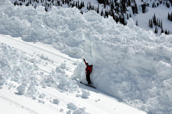
Person next to avalanche debris
A skier stand next to avalanche debris in Glacier National Park, 5/5/2011.
A skier stand next to avalanche debris in Glacier National Park, 5/5/2011.
USGS researcher standing near avalanche debris
USGS avalanche researcher evaluates avalanche debris in Glacier National Park, Montana.
USGS avalanche researcher evaluates avalanche debris in Glacier National Park, Montana.