



Geologist hikes across folded Cretaceous rocks in the central North Slope. These rocks were assessed by the USGS in 2017 and lie above the rocks assessed in the USGS 2021 Western North Slope assessment.
Images
Images from the Geology, Energy and Minerals Mission Area
Filter Total Items: 565

Western North Slope Foothills
Geologist hikes across folded Cretaceous rocks in the central North Slope. These rocks were assessed by the USGS in 2017 and lie above the rocks assessed in the USGS 2021 Western North Slope assessment.

forest tower at the Alaska Peatland Experiment
A forest tower after a storm at the Alaska Peatland Experiment, a permafrost thaw research site. The tower helps researchers understand the ecosystem’s carbon balance.
A forest tower after a storm at the Alaska Peatland Experiment, a permafrost thaw research site. The tower helps researchers understand the ecosystem’s carbon balance.
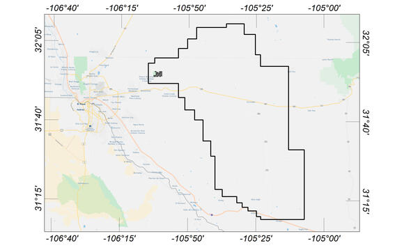
Flight area for Trans-Pecos aeromagnetic and radiometric survey
Flight area for Trans-Pecos aeromagnetic and radiometric surveyMap indicating flight area for Trans-Pecos aeromagnetic and radiometric survey. The survey area includes parts of El Paso and Hudspeth counties, Texas, and Otero County, New Mexico. Flights will begin in November 2020 and are expected to conclude in mid-January 2021.
Flight area for Trans-Pecos aeromagnetic and radiometric survey
Flight area for Trans-Pecos aeromagnetic and radiometric surveyMap indicating flight area for Trans-Pecos aeromagnetic and radiometric survey. The survey area includes parts of El Paso and Hudspeth counties, Texas, and Otero County, New Mexico. Flights will begin in November 2020 and are expected to conclude in mid-January 2021.

USGS Technicians Prepare to Take a Core of the Austin Chalk in Texas
USGS Technicians Prepare to Take a Core of the Austin Chalk in TexasUSGS technicians at the USGS Gulf Coast #4 Bonham borehole in preparation for geophysical logging of the Austin Chalk Group and the Eagle Ford Group mudstones, Fannin County, Texas.
USGS Technicians Prepare to Take a Core of the Austin Chalk in Texas
USGS Technicians Prepare to Take a Core of the Austin Chalk in TexasUSGS technicians at the USGS Gulf Coast #4 Bonham borehole in preparation for geophysical logging of the Austin Chalk Group and the Eagle Ford Group mudstones, Fannin County, Texas.

Austin Chalk Core
Bedding features in the core from the USGS Gulf Coast #4 Bonham borehole, in the Eagle Ford Group mudstones from a depth of about 401 feet, Fannin County, Texas. The Eagle Ford Group lies underneath the Austin Chalk and serves as the source rock for much of the Austin Chalk's petroleum.
Bedding features in the core from the USGS Gulf Coast #4 Bonham borehole, in the Eagle Ford Group mudstones from a depth of about 401 feet, Fannin County, Texas. The Eagle Ford Group lies underneath the Austin Chalk and serves as the source rock for much of the Austin Chalk's petroleum.

Silica Crucible and Glass Desiccator
Geochemists use platinum, silica, and ceramic crucibles, shown here in a glass container called a desiccator. Silica is used because it is resistant to extremely high temperatures and because it is chemically inert. Silicon, linked up with a pair of oxygen molecules as silicon dioxide, is known as silica.
Geochemists use platinum, silica, and ceramic crucibles, shown here in a glass container called a desiccator. Silica is used because it is resistant to extremely high temperatures and because it is chemically inert. Silicon, linked up with a pair of oxygen molecules as silicon dioxide, is known as silica.

Kokolik River Oil Sand
Oil-saturated sandstone in the Nanushuk Formation in westernmost National Petroleum Reserve in Alaska (NPR-A). Oil in these rocks likely was generated beneath Western North Slope and migrated northeastward into NPR-A.
Oil-saturated sandstone in the Nanushuk Formation in westernmost National Petroleum Reserve in Alaska (NPR-A). Oil in these rocks likely was generated beneath Western North Slope and migrated northeastward into NPR-A.

Kukpowruk Redwul
Faulted and folded petroleum source rocks in Jurassic and Cretaceous rocks (Kingak Shale, pebble shale unit, and gamma-ray zone of Hue Shale) in southern part of Western North Slope. Thermal maturity of these rocks are at the upper limit of oil preservations.
Faulted and folded petroleum source rocks in Jurassic and Cretaceous rocks (Kingak Shale, pebble shale unit, and gamma-ray zone of Hue Shale) in southern part of Western North Slope. Thermal maturity of these rocks are at the upper limit of oil preservations.

Kukpowruk Redwul
Geologist examines f Faulted and folded petroleum source rocks in Jurassic and Cretaceous rocks (Kingak Shale, pebble shale unit, and gamma-ray zone of Hue Shale) in southern part of Western North Slope. Thermal maturity of these rocks is at the upper limit of oil preservations.
Geologist examines f Faulted and folded petroleum source rocks in Jurassic and Cretaceous rocks (Kingak Shale, pebble shale unit, and gamma-ray zone of Hue Shale) in southern part of Western North Slope. Thermal maturity of these rocks is at the upper limit of oil preservations.

Tingmerkpuk Ridges
Geologists discuss the geology of Jurassic rocks in thurst-faulted structures near the southern limit of Western North Slope.
Geologists discuss the geology of Jurassic rocks in thurst-faulted structures near the southern limit of Western North Slope.

Surprise Creek, Western North Slope of Alaska
Overview of folded Triassic, Jurassic, and Cretaceous rocks in southern part of Western North Slope.
Overview of folded Triassic, Jurassic, and Cretaceous rocks in southern part of Western North Slope.

Earth MRI Funds Critical Minerals Projects in Texas
Earth MRI Funds Critical Minerals Projects in TexasUSGS map of Earth MRI projects in Texas' Trans-Pecos region announced in September 2020.
Earth MRI Funds Critical Minerals Projects in Texas
Earth MRI Funds Critical Minerals Projects in TexasUSGS map of Earth MRI projects in Texas' Trans-Pecos region announced in September 2020.

Earth MRI Funds Critical Minerals Projects in West Virginia
Earth MRI Funds Critical Minerals Projects in West VirginiaUSGS map of Earth MRI projects in West Virginia announced in September 2020.
Earth MRI Funds Critical Minerals Projects in West Virginia
Earth MRI Funds Critical Minerals Projects in West VirginiaUSGS map of Earth MRI projects in West Virginia announced in September 2020.

GeoDAWN: Geoscience Data Acquisition for Western Nevada
GeoDAWN: Geoscience Data Acquisition for Western NevadaThe USGS Earth Mapping Resources Initiative and USGS 3D Elevation Program (3DEP), Department of Energy Geothermal Technologies Office, Natural Resources Conservation Services, and Bureau of Land Management have partnered to conduct airborne geophysical and 3DEP lidar surveys over parts of Nevada and California to collect information on undiscovered geothermal, criti
GeoDAWN: Geoscience Data Acquisition for Western Nevada
GeoDAWN: Geoscience Data Acquisition for Western NevadaThe USGS Earth Mapping Resources Initiative and USGS 3D Elevation Program (3DEP), Department of Energy Geothermal Technologies Office, Natural Resources Conservation Services, and Bureau of Land Management have partnered to conduct airborne geophysical and 3DEP lidar surveys over parts of Nevada and California to collect information on undiscovered geothermal, criti

What minerals produce the colors in fireworks?
Mineral elements provide the color in fireworks. Barium produces bright greens; strontium yields deep reds; copper produces blues; and sodium yields yellow. Other colors can be made by mixing elements: strontium and sodium produce brilliant orange; titanium, zirconium, and magnesium alloys make silvery white; copper and strontium make lavender.
Mineral elements provide the color in fireworks. Barium produces bright greens; strontium yields deep reds; copper produces blues; and sodium yields yellow. Other colors can be made by mixing elements: strontium and sodium produce brilliant orange; titanium, zirconium, and magnesium alloys make silvery white; copper and strontium make lavender.

Mineral Commodities February 2020
The 43rd annual Mineral Commodity Summaries report from the USGS National Minerals Information Center is the earliest comprehensive source of 2019 world mineral production data.
The 43rd annual Mineral Commodity Summaries report from the USGS National Minerals Information Center is the earliest comprehensive source of 2019 world mineral production data.

Alaska Central North Slope - January 2020
ALASKA CENTRAL NORTH SLOPE
January 2020
One of the most productive areas in the world for oil remains rich in the resource, according to the latest USGS assessment. This assessment is for undiscovered, technically recoverable oil and gas resources in conventional accumulations.
ALASKA CENTRAL NORTH SLOPE
January 2020
One of the most productive areas in the world for oil remains rich in the resource, according to the latest USGS assessment. This assessment is for undiscovered, technically recoverable oil and gas resources in conventional accumulations.

Oil, gas, and water separation vessels
Oil, gas, and water separation vessels at a carbon dioxide enhanced oil recovery operation, Horseshoe Atoll, Upper Pennsylvanian Wolfcampian play in the Permian Basin Province in Texas.
Oil, gas, and water separation vessels at a carbon dioxide enhanced oil recovery operation, Horseshoe Atoll, Upper Pennsylvanian Wolfcampian play in the Permian Basin Province in Texas.

Gas Hydrates in Alaska 2019
The Alaska North Slope is rich in gas hydrate-bearing formations which contain significant natural gas resources. The USGS has released a geologically based assessment for how much of these resources is technically recoverable.
The Alaska North Slope is rich in gas hydrate-bearing formations which contain significant natural gas resources. The USGS has released a geologically based assessment for how much of these resources is technically recoverable.

Critical Mineral Commodities in Renewable Energy
To make America’s economy and defense more secure, the Administration has released “A Federal Strategy to Ensure Secure and Reliable Supplies of Critical Minerals.” Among other roles, these mineral commodities are vital to renewable energy infrastructure like solar panels, wind turbines, and batteries.
To make America’s economy and defense more secure, the Administration has released “A Federal Strategy to Ensure Secure and Reliable Supplies of Critical Minerals.” Among other roles, these mineral commodities are vital to renewable energy infrastructure like solar panels, wind turbines, and batteries.

Tungsten
Photo Contest Winner | March 2020 | Honorable Mention 1
Critical mineral - tungsten
Photo Contest Winner | March 2020 | Honorable Mention 1
Critical mineral - tungsten