



USGS personnel on the deck of the R/V Hugh R.
Images
Images from the Geology, Energy and Minerals Mission Area
Filter Total Items: 565

Retrieving Seismic Airguns
USGS personnel on the deck of the R/V Hugh R.

USGS Denver Federal Center Building 25 Entrance
USGS Denver Federal Center Building 25 Entrance
USGS Denver Federal Center Building 25 Entrance

Eagle Ford Test Well Drilling in Texas
USGS researchers drill a research well located on the south side of U.S. 90, 7.1 miles east of Brackettville, Texas. This core was drilled by USGS during field work for an oil and gas assessment for the Eagle Ford of the Gulf Coast Basins. Cores like these provide information on the various rock layers, such as their make-up, their age, etc.
USGS researchers drill a research well located on the south side of U.S. 90, 7.1 miles east of Brackettville, Texas. This core was drilled by USGS during field work for an oil and gas assessment for the Eagle Ford of the Gulf Coast Basins. Cores like these provide information on the various rock layers, such as their make-up, their age, etc.

Natural oil seep along Tarwater Creek, San Mateo County, California
Natural oil seep along Tarwater Creek, San Mateo County, CaliforniaThe natural oil seep in this photo is located in Pescadero Creek County Park, where the Canyon Trail crosses Tarwater Creek. The oil is black, has a taffy-like consistency, and smells like motor oil.

Oil well pumping unit, Half Moon Bay oil field, California
Oil well pumping unit, Half Moon Bay oil field, CaliforniaThe Half Moon Bay oil field is one of the oldest oil fields in California and was first developed during the 1880s. Since then, the field has produced an estimated 60,000 barrels of oil from about 19 wells.

USGS in South Korea
Tim Collett, USGS research geologist, presenting at the Korean Institute of Geoscience and Mineral Resources' (KIGAM) international program for geoscience resources.
Tim Collett, USGS research geologist, presenting at the Korean Institute of Geoscience and Mineral Resources' (KIGAM) international program for geoscience resources.

Gas Hydrate from offshore Korea
Gas hydrate from offshore Korea courtesy of the Korean Institute of Geoscience and Mineral Resources. Learn more about gas hydrates at https://woodshole.er.usgs.gov/project-pages/hydrates/
Gas hydrate from offshore Korea courtesy of the Korean Institute of Geoscience and Mineral Resources. Learn more about gas hydrates at https://woodshole.er.usgs.gov/project-pages/hydrates/

USGS in Daejon, South Korea
USGS scientists, Bill Waite, Tim Collett, and Seth Haines in front of a archway in Daejeon, South Korea
USGS scientists, Bill Waite, Tim Collett, and Seth Haines in front of a archway in Daejeon, South Korea

Core Storage Facility in Daejeon, South Korea
Core storage facility at the the Korean Institute of Geoscience and Mineral Resources in Daejeon, South Korea
Core storage facility at the the Korean Institute of Geoscience and Mineral Resources in Daejeon, South Korea

USGS research geologist, Tim Collett
Tim Collett, research geologist in gas hydrates, is chief for the U.S. Geological Survey (USGS) Energy Resources Program gas hydrate research efforts offering a presentation on unconventional oil and gas resources at KIGAM, the Korean Institute of Geoscience and Mineral Resources in Daejeon, South Korea
Tim Collett, research geologist in gas hydrates, is chief for the U.S. Geological Survey (USGS) Energy Resources Program gas hydrate research efforts offering a presentation on unconventional oil and gas resources at KIGAM, the Korean Institute of Geoscience and Mineral Resources in Daejeon, South Korea

Gas Hydrate and Sediment Pressure Chamber
Seth Haines, USGS research geophysicist, on a Korean Institute of Geoscience and Mineral Resources laboratory tour, which included stops at their gas hydrate and sediment pressure chamber - it's a whopping 320 gallons, dwarfing even Seth, a 6-footer. The chamber is the silvery ring and the black cylinder beneath it. It's so big and heavy
Seth Haines, USGS research geophysicist, on a Korean Institute of Geoscience and Mineral Resources laboratory tour, which included stops at their gas hydrate and sediment pressure chamber - it's a whopping 320 gallons, dwarfing even Seth, a 6-footer. The chamber is the silvery ring and the black cylinder beneath it. It's so big and heavy

The US relies on these countries for 50% or more of certain minerals
The US relies on these countries for 50% or more of certain mineralsThis map shows the countries that supply mineral commodities for which the United States was more than 50 percent import reliant in 2017.
The US relies on these countries for 50% or more of certain minerals
The US relies on these countries for 50% or more of certain mineralsThis map shows the countries that supply mineral commodities for which the United States was more than 50 percent import reliant in 2017.

Fish Creek Watershed in the National Petroleum Reserve-Alaska
Fish Creek Watershed in the National Petroleum Reserve-AlaskaFish Creek wanders through the National Petroleum Reserve-Alaska, a 22.8 million acre region managed by the Bureau of Land Management on Alaska's North Slope. USGS has periodically assessed oil and gas resource potential there. These assessments can be found here.

Permafrost in the National Petroleum Reserve-Alaska
Permafrost in the National Petroleum Reserve-AlaskaPermafrost forms a grid-like pattern in the National Petroleum Reserve-Alaska, a 22.8 million acre region managed by the Bureau of Land Management on Alaska's North Slope. USGS has periodically assessed oil and gas resource potential there. These assessments can be found here.

Seafloor crust, Marshall Islands
Cross section of a seafloor crust (AKA, ferromanganese or cobalt-rich crusts) from the Marshall Islands collected at almost 2,000 meters depth.
Cross section of a seafloor crust (AKA, ferromanganese or cobalt-rich crusts) from the Marshall Islands collected at almost 2,000 meters depth.

Scientist holding a sample of lepidolite
A scientist holds a sample of lepidolite.
A scientist holds a sample of lepidolite.

Minerals in Mobile Devices — Infographic
This infographic displays the different minerals located in mobile devices. Included within this infographic are:
This infographic displays the different minerals located in mobile devices. Included within this infographic are:
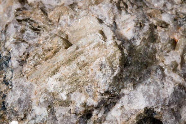
Spodumene
Mineral origin: Hallman Beam Mine, Cherryville, NC
Primary mineral commodity: Lithium
Uses: batteries for cell phones, laptops, and electric and hybrid vehicles
Mineral origin: Hallman Beam Mine, Cherryville, NC
Primary mineral commodity: Lithium
Uses: batteries for cell phones, laptops, and electric and hybrid vehicles

Salt, Sodium, Chlorine
Mineral: Halite (NaCl)
Primary mineral Commodity: Salt
Mineral: Halite (NaCl)
Primary mineral Commodity: Salt

Molybdenite
Mineral: Molybdenite
Mineral Origin: Henderson Mine, Empire, CO
Primary Mineral Commodity: Molybdenum
Mineral: Molybdenite
Mineral Origin: Henderson Mine, Empire, CO
Primary Mineral Commodity: Molybdenum

Lead
Lead is a corrosion-resistant dense metal that is easily molded and shaped. 85% of lead in the US is used for lead-acid batteries, which are used in automobiles, as industrial-type batteries for standby power for computer and telecommunications networks, and for motive power.
Lead is a corrosion-resistant dense metal that is easily molded and shaped. 85% of lead in the US is used for lead-acid batteries, which are used in automobiles, as industrial-type batteries for standby power for computer and telecommunications networks, and for motive power.