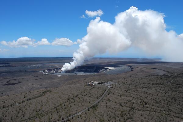
Launching a sonobuoy receiver off the end of CCGS Louis S. St-Laurent
Images
Images related to natural hazards.
Launching a sonobuoy receiver off the end of CCGS Louis S. St-Laurent
USGS researcher Benjamin Jones examines a collapsed block of ice-rich permafrost on Barter Island along Alaska's Arctic coast.
Nighttime view of tephra-jet explosion, Kīlauea, Hawai‘i
Nighttime view of tephra-jet explosion, Kīlauea, Hawai‘iIncandescent arcs trace the path of lava fragments cast out during a tephra-jet explosion at the Waikupanaha ocean entry in 2008. This is a relatively small explosion, reaching a few tens of meters (yards) height, while one earlier in the day was nearly 70 meters (230 ft) in height.
When lava from the Pu'u 'Ō'ō-Kupaianaha eruption, active since 1983, meets the ocean, large littoral explosions can result.
Crater Lake Caldera with Wizard Island cinder cone and lava flows, ...
Crater Lake Caldera with Wizard Island cinder cone and lava flows, ...Crater Lake Caldera with Wizard Island cinder cone and lava flows, some of the youngest features in the caldera as seen from Merriam Point. Viewed toward the south. Oregon
The early morning helicopter overflight of the lower East Rift Zone shows lava continuing to enter the sea at Ahalanui. The southern margin of the flow remains about a quarter mile from the boat ramp at Isaac Hale Park (jetty visible in the center left of the photo). View to the northeast.
Photograph of the Donghekou Landslide, triggered by the 2008 Wenchuan, China Earthquake. This landslide had 3 sources areas: the mountain slope at the top right of the photograph a second area primarily resulting in a rockslide that occurred to the left of the scientists, and one to the right, across the river (not shown in picture).
Train tracks and overwater structures along Browns Bay in Edmonds, Washington often occur on developed shorelines of Puget Sound. The built environment can interrupt the flow of sediment from back-beach bluffs to the intertidal zone, attenuate and redirect alongshore currents, and reduce upper beach habitat.
Clear day during tradewind conditions at the summit of Kīlauea
Clear day during tradewind conditions at the summit of KīlaueaClear day during tradewind conditions at the summit of Kīlauea Volcano, Hawai‘i
Clear day during tradewind conditions at the summit of Kīlauea
Clear day during tradewind conditions at the summit of KīlaueaClear day during tradewind conditions at the summit of Kīlauea Volcano, Hawai‘i
High bank and flood plain of Short Creek (a tributary of the Souris River in North Dakota) below International Boundary near Roche Percee, Saskatchewan, Canada.
Flooded vehicles
Flooding downtown
Flooding downtown near 1st Street and A Ave.
Flooding downtown
Flooding downtown
Rescuing flood victims
Rescuing victims
Flooding downtown near 1st Street and A Ave.
Rescuing flood victims
Flooded street