
USGS crews had two research vessels out measuring streamflow on the Mississippi River at St. Louis on New Years Eve. USGS scientists Eric Looper and Jason Carron are one of many USGS field crews out in the floodwaters over the holiday.
Images
Explore water-related photography, imagery, and illustrations.
Filter Total Items: 2553

USGS Measures Historic Flooding Across the Nation
USGS crews had two research vessels out measuring streamflow on the Mississippi River at St. Louis on New Years Eve. USGS scientists Eric Looper and Jason Carron are one of many USGS field crews out in the floodwaters over the holiday.

USGS Measures Historic Flooding Across the Nation
USGS scientists Chris Rowden, Larry Buschmann and Bob Holmes dock the boat and coordinate with emergency managers.
USGS scientists Chris Rowden, Larry Buschmann and Bob Holmes dock the boat and coordinate with emergency managers.

USGS Measures Historic Flooding Across the Nation
Record flooding on the Meramec River near Eureka, Missouri. This area is close to a USGS streamgage and water quality monitoring station.
Record flooding on the Meramec River near Eureka, Missouri. This area is close to a USGS streamgage and water quality monitoring station.

December Rainfall
December 29. 2015 14-Day Observed Precipitation - Continental United States
December 29. 2015 14-Day Observed Precipitation - Continental United States

Documenting High Water
USGS Hydrologic Technician Christopher Rowden is seen here documenting a high water mark on Maries River at Westphalia, MO.
USGS Hydrologic Technician Christopher Rowden is seen here documenting a high water mark on Maries River at Westphalia, MO.

USGS gage 14120000 Hood River at Tucker Bridge, near Hood River, OR

Sampling point for a large-volume public-supply well
Sampling point for a large-volume public-supply wellA large-volume public supply well in San Antonio, Texas. This well is being sampled for water-quality constituents as part of the NAWQA Enhanced Trend Network project.
Sampling point for a large-volume public-supply well
Sampling point for a large-volume public-supply wellA large-volume public supply well in San Antonio, Texas. This well is being sampled for water-quality constituents as part of the NAWQA Enhanced Trend Network project.

Sampling point for a large-volume public-supply well
Sampling point for a large-volume public-supply wellA large-volume public supply well in San Antonio, Texas. This well is being sampled for water-quality constituents as part of the NAWQA Enhanced Trend Network project.
Sampling point for a large-volume public-supply well
Sampling point for a large-volume public-supply wellA large-volume public supply well in San Antonio, Texas. This well is being sampled for water-quality constituents as part of the NAWQA Enhanced Trend Network project.

USGS Streamgage on the Williamson River
A U.S. Geological Survey hydrologist collects a water sample from the Williamson River below Chiloquin, Oregon. The sample was analyzed as part of a water-quality study the USGS conducted in cooperation with the U.S. Bureau of Reclamation and the Klamath Tribes.
A U.S. Geological Survey hydrologist collects a water sample from the Williamson River below Chiloquin, Oregon. The sample was analyzed as part of a water-quality study the USGS conducted in cooperation with the U.S. Bureau of Reclamation and the Klamath Tribes.

2015 Great Salt Lake Breach at Lakeside, Utah
For the first time since it was opened in 1984, water has stopped flowing through the Great Salt Lake causeway breach, an area that allows water to travel between the southern and northern parts of the lake.
For the first time since it was opened in 1984, water has stopped flowing through the Great Salt Lake causeway breach, an area that allows water to travel between the southern and northern parts of the lake.

Great Salt Lake Breach at Lakeside, Utah
A gage to measure lake water levels stands dry in the lake bed of the Great Salt Lake. For the first time since it was opened in 1984, water has stopped flowing through the Great Salt Lake causeway breach, an area that allows water to travel between the southern and northern parts of the lake.
A gage to measure lake water levels stands dry in the lake bed of the Great Salt Lake. For the first time since it was opened in 1984, water has stopped flowing through the Great Salt Lake causeway breach, an area that allows water to travel between the southern and northern parts of the lake.

A U.S. Geological Survey hydrologist collects a water sample
A U.S. Geological Survey hydrologist collects a water sampleAfter receiving permission from the homeowner, a U.S. Geological Survey hydrologist collects a water sample from a residential well in Emmett, Idaho. The sample was analyzed as part of a water-quality study the USGS conducted in cooperation with Gem County, Idaho and the Idaho Department of Environmental Quality.

Remote geophysical sensor
This sensor, called a bird, is tethered to a helicopter during USGS geophysical surveys. As the helicopter flies low over specific areas, the bird transmits electromagnetic waves deep into the ground to measure the below-surface physical properties. This scientific system is called Resolve and is operated by CGG Canada Servives, Ltd.
This sensor, called a bird, is tethered to a helicopter during USGS geophysical surveys. As the helicopter flies low over specific areas, the bird transmits electromagnetic waves deep into the ground to measure the below-surface physical properties. This scientific system is called Resolve and is operated by CGG Canada Servives, Ltd.

USGS Scientist Inspects Streamgage During Flooding Event
USGS Scientist Inspects Streamgage During Flooding EventUSGS scientist Matt Jennings inspects streamgage number 02136361 at Turkey Creek near Maryville, South Carolina, the morning of October 4, 2015. The discharge they measured was 6,000 cfs.
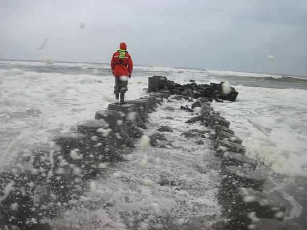
Simonson Joaquin 2015 10 03 AS 017 (1).JPG
USGS scientist measuring high water marks on a jetty into the Long Island Sound during flooding in October of 2015.
USGS scientist measuring high water marks on a jetty into the Long Island Sound during flooding in October of 2015.

Resolve low-level flight system
In this image, a helicopter towing a large, cylindrical sensor makes low-level flights as part of a USGS remote geophysical survey, which collects data about underground geology. The scientific system, called Resolve, is operated by CGG Canada Services, Ltd.
In this image, a helicopter towing a large, cylindrical sensor makes low-level flights as part of a USGS remote geophysical survey, which collects data about underground geology. The scientific system, called Resolve, is operated by CGG Canada Services, Ltd.

Flooding around Mill River streamflow gage 01171500 at Northampton, MA
Flooding around Mill River streamflow gage 01171500 at Northampton, MAFlooding around Mill River USGS streamflow gage 01171500 at Northampton, Massachusetts.
Flooding around Mill River streamflow gage 01171500 at Northampton, MA
Flooding around Mill River streamflow gage 01171500 at Northampton, MAFlooding around Mill River USGS streamflow gage 01171500 at Northampton, Massachusetts.

Harmful algal blooms turn water in Milford Lake emerald green
Harmful algal blooms turn water in Milford Lake emerald greenHarmful algal blooms turn water in Milford Lake emerald green
Harmful algal blooms turn water in Milford Lake emerald green
Harmful algal blooms turn water in Milford Lake emerald greenHarmful algal blooms turn water in Milford Lake emerald green

Hoover Dam looking upstream on the Colorado River.
Hoover Dam looking upstream on the Colorado River.Hoover Dam looking upstream on the Colorado River.
Hoover Dam looking upstream on the Colorado River.
Hoover Dam looking upstream on the Colorado River.Hoover Dam looking upstream on the Colorado River.

I-Beam and Sled ADVM Mount 2
A 4" aluminum I-beam is used allow an ADVM to be raised and lowered on a stainless steel sled. The I-beam also serves as a pedestal mount for electronics housing.
A 4" aluminum I-beam is used allow an ADVM to be raised and lowered on a stainless steel sled. The I-beam also serves as a pedestal mount for electronics housing.

USGS Deploys Crews to Site of Flash Flood
USGS crews are taking measurements following a flash flood event in Hildale, Utah.
USGS crews are taking measurements following a flash flood event in Hildale, Utah.