
Regional Water Availability Assessment: Upper Colorado River Basin
From Snow to Flow
New data visualization explores what changing snowmelt means for water availability in the western U.S.
Regional Water Availability Assessments are scientific assessments of water availability in different hydrologic regions across the Nation. In the Upper Colorado River Basin, the USGS will conduct a focused assessment of how snowpack and snowmelt influence hydrology and water quality, and an integrated and comprehensive assessment of multiple water quantity, quality and use factors.
Regional Water Availability Assessments are detailed scientific studies of water availability, conducted in medium-sized watersheds located throughout the Nation. These Integrated Water Availability Assessments, occurring in Integrated Water Science basins, evaluate water quantity and quality in both surface and groundwater, determine whether there is enough water for human and ecosystem needs, and understand how human and natural influences affect the amount of available water. Regional Water Availability Assessments address important water resource questions in the basin in ways that support local stakeholders and improve the USGS’s national water availability assessment capacity.
The Colorado River and its tributaries supply drinking water for 40 million people in the U.S. and Mexico, irrigation water for 5.5 million acres of land, and are essential sources of water for at least 29 federally recognized tribes, 7 National Wildlife Refuges, 4 National Recreation Areas, and 11 National Parks (Bureau of Reclamation, 2012; Bureau of Reclamation and Colorado River Basin Ten Tribes Partnership, 2018). The Upper Colorado River Basin (UCOL) was selected as an Integrated Water Science basin in 2019. The UCOL water availability assessment studies will focus on the area of the UCOL watershed upstream of Lee’s Ferry, Arizona. A smaller sub-basin that includes the Colorado headwaters and Gunnison River Basins is being intensively monitored by the Next Generation Water Observing System (NGWOS).
Accumulation of an annual winter snowpack in the mountains and subsequent spring snowmelt are primary drivers of hydrology of the UCOL. High-altitude areas in the UCOL are cold enough to receive most of their precipitation as winter snow that accumulates as a seasonal snowpack. These areas produce a large portion of the runoff to streams in the basin, where about 15 percent of the basin area contributes about 85 percent of the mean-annual runoff (Lukas and Payton, 2020). Snow that falls and accumulates in the UCOL headwaters is eventually delivered to and stored in two major reservoirs - Lake Powell and Lake Mead. These reservoirs serve as critical water supplies for the Lower Colorado River basin. A 2022 UCOL Regional Water Availability Assessment publication summarizes the state of snow, and other priority water availability components in the UCOL, including streamflow, total dissolved solids (TDS; a proxy for salinity) in groundwater and surface water, and groundwater levels and storage. Each of these components plays an important role in understanding the UCOL water cycle and water quality.
Upper Colorado River Basin Regional Water Availability Phases
Phase 1 of the Regional Water Availability Assessment, which formally began in 2021, will last five years and will focus on addressing a regionally relevant threat to water availability. Phase 2 of the assessment will begin in 2026, will last five years, and will include a broader regional evaluation of water supply and demand.
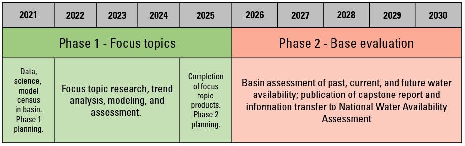
Regional Water Availability Assessments in IWS Basins are conducted in two general Phases:
Phase 1 - Focus topic: A focused assessment of regionally relevant threats to water availability
Regional Assessments begin in Phase 1 by addressing regionally important water resource questions in ways that both support local stakeholders and improve national assessment capacity. A small number of focus topics are identified by the USGS Water Mission Area at the time of IWS Basin selection, guided by national model gaps and stakeholder needs in the basin. This phase of the assessment will (1) answer key science questions in the region related to the focus topic; (2) develop new process understanding and modeling capacity that fills a gap in the region and supports national models and assessments; and (3) predict future changes in water availability for humans or aquatic life, as related to the focus topic.
Owing to the importance of snow processes on UCOL hydrology and water quality, the UCOL focus topic addresses the effects of snow conditions on water availability. The goal of Phase 1 is to improve understanding of how snow accumulation and melt processes contribute to surface and groundwater availability. Specifically, Phase 1 will address two primary water availability questions:
- How have changes in snowpack in the UCOL headwaters translated to changes in other water budget components throughout the basin and how will these changes vary in the future?
- What is the sensitivity of total dissolved solids concentrations and loads to changes in snow hydrology?
Changes in climate are affecting the amount of snow accumulation, the timing of snow melt, and the relative contribution of precipitation that falls as rain versus snow (Mote and others, 2018; Milly and Dunne, 2020; Musselman and others, 2021). These changes are expected to continue in the future (Talsma and others, 2022), and projecting the effects of these changes on water availability is required to help inform plans for meeting future water demand in the basin.
Phase 2 - Base evaluation: A regional evaluation of water supply and demand
The Regional Assessments continue in Phase 2 with a broader evaluation—an integrated and comprehensive evaluation of factors affecting water availability in the region, inclusive of water quantity, quality, and use. This base evaluation will explore targeted future tipping points —when water no longer meets our standards for a given use — and human and ecosystem vulnerabilities in the region. A consistent approach will be used in each Regional Assessment to allow for comparing and contrasting limits to past, current, and future water availability in different parts of the Nation in more detail than will be possible using national-scale assessments. The regional base evaluation will complement the National Water Availability Assessment by answering similar water availability questions, but in more detail, and tailored toward important regional water issues.
Below are other science projects associated with IWAAs and the Upper Colorado River Basin.
Integrated Water Science Basins: Upper Colorado River

Integrated Water Availability Assessments

Regional Water Availability Assessment: Delaware River Basin

Integrated Water Science (IWS) Basins

Next Generation Water Observing System (NGWOS)

Next Generation Water Observing System: Upper Colorado River Basin
Regional Water Availability Assessments are scientific assessments of water availability in different hydrologic regions across the Nation. In the Upper Colorado River Basin, the USGS will conduct a focused assessment of how snowpack and snowmelt influence hydrology and water quality, and an integrated and comprehensive assessment of multiple water quantity, quality and use factors.
Regional Water Availability Assessments are detailed scientific studies of water availability, conducted in medium-sized watersheds located throughout the Nation. These Integrated Water Availability Assessments, occurring in Integrated Water Science basins, evaluate water quantity and quality in both surface and groundwater, determine whether there is enough water for human and ecosystem needs, and understand how human and natural influences affect the amount of available water. Regional Water Availability Assessments address important water resource questions in the basin in ways that support local stakeholders and improve the USGS’s national water availability assessment capacity.
The Colorado River and its tributaries supply drinking water for 40 million people in the U.S. and Mexico, irrigation water for 5.5 million acres of land, and are essential sources of water for at least 29 federally recognized tribes, 7 National Wildlife Refuges, 4 National Recreation Areas, and 11 National Parks (Bureau of Reclamation, 2012; Bureau of Reclamation and Colorado River Basin Ten Tribes Partnership, 2018). The Upper Colorado River Basin (UCOL) was selected as an Integrated Water Science basin in 2019. The UCOL water availability assessment studies will focus on the area of the UCOL watershed upstream of Lee’s Ferry, Arizona. A smaller sub-basin that includes the Colorado headwaters and Gunnison River Basins is being intensively monitored by the Next Generation Water Observing System (NGWOS).
Accumulation of an annual winter snowpack in the mountains and subsequent spring snowmelt are primary drivers of hydrology of the UCOL. High-altitude areas in the UCOL are cold enough to receive most of their precipitation as winter snow that accumulates as a seasonal snowpack. These areas produce a large portion of the runoff to streams in the basin, where about 15 percent of the basin area contributes about 85 percent of the mean-annual runoff (Lukas and Payton, 2020). Snow that falls and accumulates in the UCOL headwaters is eventually delivered to and stored in two major reservoirs - Lake Powell and Lake Mead. These reservoirs serve as critical water supplies for the Lower Colorado River basin. A 2022 UCOL Regional Water Availability Assessment publication summarizes the state of snow, and other priority water availability components in the UCOL, including streamflow, total dissolved solids (TDS; a proxy for salinity) in groundwater and surface water, and groundwater levels and storage. Each of these components plays an important role in understanding the UCOL water cycle and water quality.
Upper Colorado River Basin Regional Water Availability Phases
Phase 1 of the Regional Water Availability Assessment, which formally began in 2021, will last five years and will focus on addressing a regionally relevant threat to water availability. Phase 2 of the assessment will begin in 2026, will last five years, and will include a broader regional evaluation of water supply and demand.
Regional Water Availability Assessments in IWS Basins are conducted in two general Phases:
Phase 1 - Focus topic: A focused assessment of regionally relevant threats to water availability
Regional Assessments begin in Phase 1 by addressing regionally important water resource questions in ways that both support local stakeholders and improve national assessment capacity. A small number of focus topics are identified by the USGS Water Mission Area at the time of IWS Basin selection, guided by national model gaps and stakeholder needs in the basin. This phase of the assessment will (1) answer key science questions in the region related to the focus topic; (2) develop new process understanding and modeling capacity that fills a gap in the region and supports national models and assessments; and (3) predict future changes in water availability for humans or aquatic life, as related to the focus topic.
Owing to the importance of snow processes on UCOL hydrology and water quality, the UCOL focus topic addresses the effects of snow conditions on water availability. The goal of Phase 1 is to improve understanding of how snow accumulation and melt processes contribute to surface and groundwater availability. Specifically, Phase 1 will address two primary water availability questions:
- How have changes in snowpack in the UCOL headwaters translated to changes in other water budget components throughout the basin and how will these changes vary in the future?
- What is the sensitivity of total dissolved solids concentrations and loads to changes in snow hydrology?
Changes in climate are affecting the amount of snow accumulation, the timing of snow melt, and the relative contribution of precipitation that falls as rain versus snow (Mote and others, 2018; Milly and Dunne, 2020; Musselman and others, 2021). These changes are expected to continue in the future (Talsma and others, 2022), and projecting the effects of these changes on water availability is required to help inform plans for meeting future water demand in the basin.
Phase 2 - Base evaluation: A regional evaluation of water supply and demand
The Regional Assessments continue in Phase 2 with a broader evaluation—an integrated and comprehensive evaluation of factors affecting water availability in the region, inclusive of water quantity, quality, and use. This base evaluation will explore targeted future tipping points —when water no longer meets our standards for a given use — and human and ecosystem vulnerabilities in the region. A consistent approach will be used in each Regional Assessment to allow for comparing and contrasting limits to past, current, and future water availability in different parts of the Nation in more detail than will be possible using national-scale assessments. The regional base evaluation will complement the National Water Availability Assessment by answering similar water availability questions, but in more detail, and tailored toward important regional water issues.
Below are other science projects associated with IWAAs and the Upper Colorado River Basin.
Integrated Water Science Basins: Upper Colorado River
Integrated Water Availability Assessments
Regional Water Availability Assessment: Delaware River Basin
Integrated Water Science (IWS) Basins
Next Generation Water Observing System (NGWOS)