
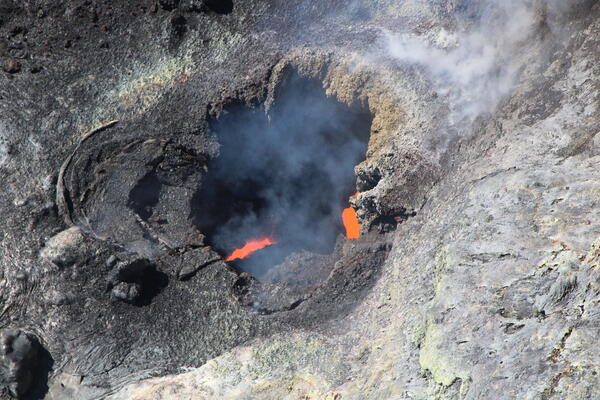
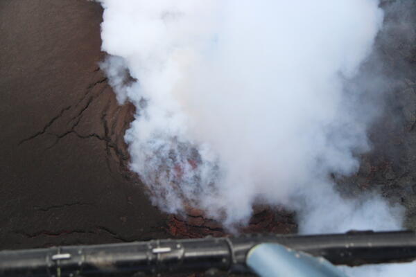
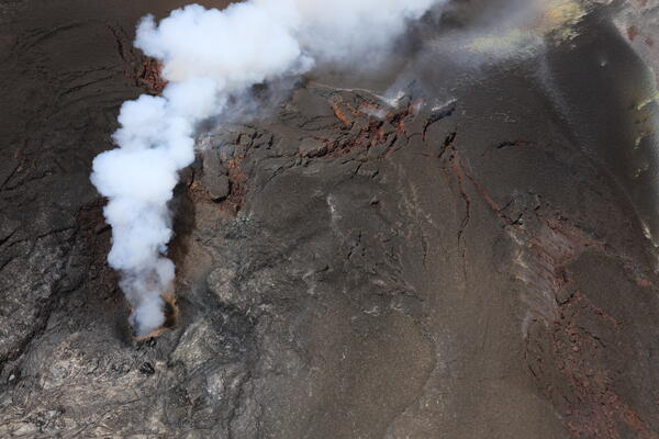
This aerial view, looking down into the north vent in Halema‘uma‘u, was taken during a USGS Hawaiian Volcano Observatory monitoring overflight on the morning of July 14, 2026. Small amounts of spatter over the last 12 hours have deposited on and around the vent, giving it a more textured look in the interior part of the depression.
Images
Hawaiian Volcano Observatory images of eruptive activity, field work, and more.
Filter Total Items: 4072
July 14, 2026 — A view into north vent, Kīlauea
This aerial view, looking down into the north vent in Halema‘uma‘u, was taken during a USGS Hawaiian Volcano Observatory monitoring overflight on the morning of July 14, 2026. Small amounts of spatter over the last 12 hours have deposited on and around the vent, giving it a more textured look in the interior part of the depression.
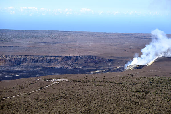
July 14, 2026 — Halema‘uma‘u with Uēkahuna, Kīlauea
July 14, 2026 — Halema‘uma‘u with Uēkahuna, KīlaueaA view of Halema‘uma‘u with Uēkahuna in the foreground. Uēkahuna is the celebrated wahi pana (legendary place) of Kaluapele, the caldera of Kīlauea. An important site for Native Hawaiian ritual and cultural practices, Uēkahuna presents visitors with spectacular vistas of Kaluapele, Mauna Loa, and surrounding areas from the highest point on the rim.
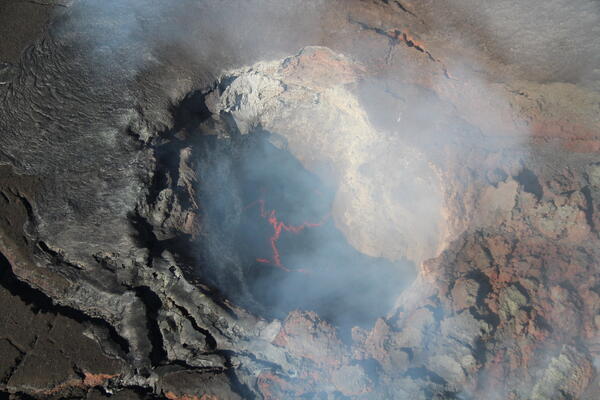
July 14, 2026 — View into Halema‘uma‘u south vent, Kīlauea
July 14, 2026 — View into Halema‘uma‘u south vent, KīlaueaDuring the July 14 monitoring overflight of Kīlauea's summit region, a USGS Hawaiian Volcano Observatory scientist captured this telephoto view into the south vent in Halema‘uma‘u. Unlike the incandescent but spattering north vent, the south vent hosted an active lava pond within.
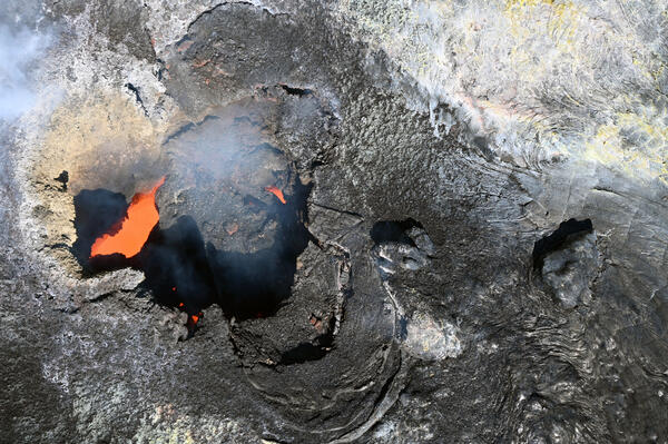
July 14, 2026 — View into Halema‘uma‘u north vent, Kīlauea
July 14, 2026 — View into Halema‘uma‘u north vent, KīlaueaOn July 14, USGS Hawaiian Volcano Observatory scientists on a monitoring overflight of Kīlauea's summit region had excellent views into both eruptive vents in Halema‘uma‘u. This is a telephoto view into the north vent, where the scientists could see two incandescent pukas (holes); the one on the left in this view was actively spattering during the flight.
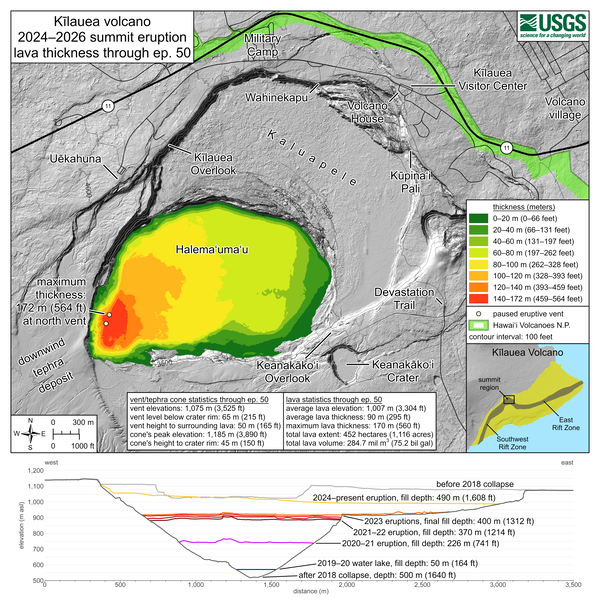
July 10, 2026—Kīlauea summit eruption lava thickness through episode 50
July 10, 2026—Kīlauea summit eruption lava thickness through episode 50This map shows thickness values for lava flows within Halema‘uma‘u crater from the Kīlauea summit eruption that began on December 23, 2024. These values were calculated by topographic differencing between a digital elevation model collected on June 30, 2026—after eruptive episode 50—and one from before the eruption began.
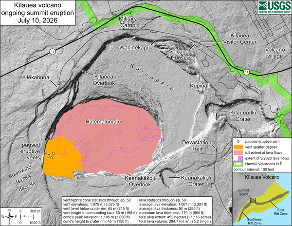
July 10, 2026—Kīlauea summit eruption reference map
July 10, 2026—Kīlauea summit eruption reference mapThis reference map depicts the Kīlauea summit eruption within Halema‘uma‘u crater that began on December 23, 2024. Most of the data for this map were collected during a USGS Hawaiian Volcano Observatory helicopter overflight on June 30, 2026, so the provided statistics are reflective of the entire eruption through episode 50 on June 27.
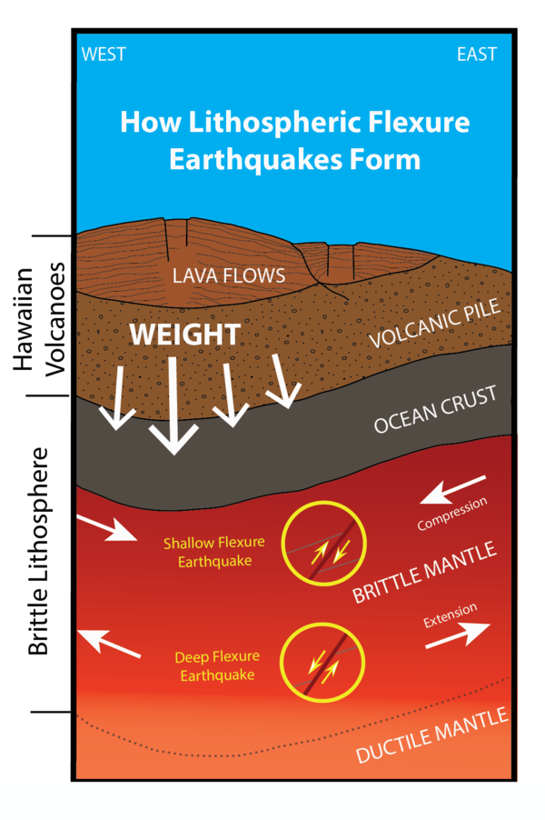
How lithospheric flexure earthquakes form in the State of Hawaii
How lithospheric flexure earthquakes form in the State of HawaiiThis graphic depicts how the weight of volcanoes in the Hawaiian Island Chain can cause the brittle oceanic crust and upper mantle below to flex downward, which can generate deep earthquakes that can be widely felt across the State of Hawaii. USGS graphic.
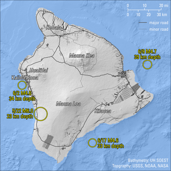
Magnitude 4.5 and greater earthquakes beneath the Island of Hawaiʻi in May and June 2026
Magnitude 4.5 and greater earthquakes beneath the Island of Hawaiʻi in May and June 2026This map figure shows the locations of magnitude-4.5 and greater earthquakes around the Island of Hawaiʻi in May and June 2026. A magnitude-6.0 earthquake on May 22 occurred beneath the west side of the Island of Hawaiʻi, southeast of Captain Cook at a depth of 14 miles (23 km) below the ocean surface.
July 7, 2026 — Lava in Halema‘uma‘u south vent, Kīlauea summit
July 7, 2026 — Lava in Halema‘uma‘u south vent, Kīlauea summitDuring the USGS Hawaiian Volcano Observatory Kīlauea summit monitoring overflight on July 7, geologists had to look straight down into the south vent in Halema‘uma‘u to see the active lave pond within.
July 7, 2026 — Eruptive vent complex in Halema‘uma‘u, Kīlauea summit
July 7, 2026 — Eruptive vent complex in Halema‘uma‘u, Kīlauea summitOn Tuesday, July 7, USGS Hawaiian Volcano Observatory geologists completed a brief monitoring helicopter overflight of Halema‘uma‘u crater at the summit of Kīlauea.
Filling of Halemaʻumaʻu in Kaluapele (Kīlauea's summit caldera) as a result of 50 episodes of lava fountaining since December 23, 2024
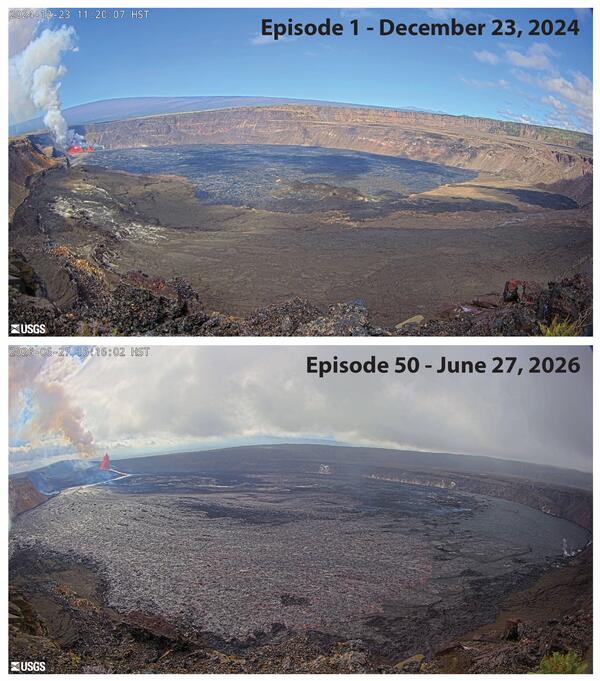
Filling of Halemaʻumaʻu in Kaluapele (Kīlauea's summit caldera) as a result of 50 episodes of lava fountaining since December 23, 2024These before-and-after images show the filling of Halemaʻumaʻu in Kaluapele (Kīlauea's summit caldera) with lava due to 50 episodes of lava fountaining. The top image was taken by the B1cam during episode 1 of the eruption on December 23, 2024. The bottom image was taken by the B1cam on June 27, 2026, during episode 50 of the eruption. USGS webcam images.
Filling of Halemaʻumaʻu in Kaluapele (Kīlauea's summit caldera) as a result of 50 episodes of lava fountaining since December 23, 2024
Filling of Halemaʻumaʻu in Kaluapele (Kīlauea's summit caldera) as a result of 50 episodes of lava fountaining since December 23, 2024These before-and-after images show the filling of Halemaʻumaʻu in Kaluapele (Kīlauea's summit caldera) with lava due to 50 episodes of lava fountaining. The top image was taken by the B1cam during episode 1 of the eruption on December 23, 2024. The bottom image was taken by the B1cam on June 27, 2026, during episode 50 of the eruption. USGS webcam images.
July 2, 2026 — Tephra sampling in Halema‘uma‘u, Kīlauea
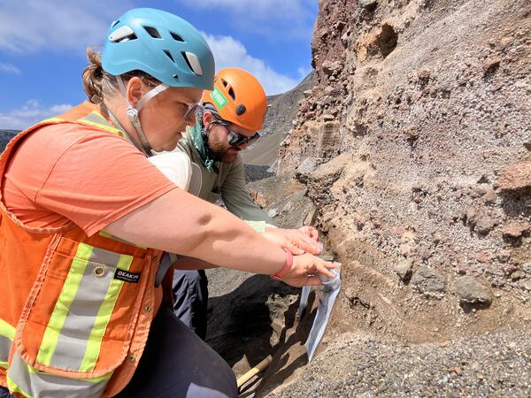
July 2, 2026 — Tephra sampling in Halema‘uma‘u, KīlaueaThis photo was captured during the July 2 mission to the northwest side of Halema‘uma‘u crater, which was done with permission from and coordination with Hawai‘i Volcanoes National Park. The two USGS Hawaiian Volcano Observatory scientists pictured here are collecting tephra from a deposit exposed in the northwest crater wall.
July 2, 2026 — Tephra sampling in Halema‘uma‘u, Kīlauea
July 2, 2026 — Tephra sampling in Halema‘uma‘u, KīlaueaThis photo was captured during the July 2 mission to the northwest side of Halema‘uma‘u crater, which was done with permission from and coordination with Hawai‘i Volcanoes National Park. The two USGS Hawaiian Volcano Observatory scientists pictured here are collecting tephra from a deposit exposed in the northwest crater wall.
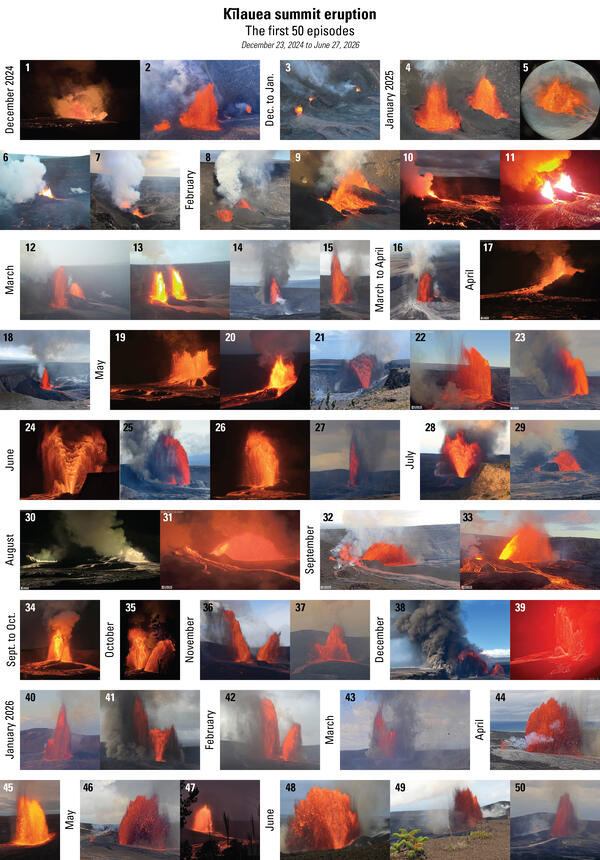
Photo compilation of lava fountaining episodes 1–50 of the ongoing eruption at the summit of Kīlauea
Photo compilation of lava fountaining episodes 1–50 of the ongoing eruption at the summit of KīlaueaPhoto compilation of lava fountaining episodes 1–50 in the ongoing eruption at the summit of Kīlauea, including webcam imagery and photos taken by USGS Hawaiian Volcano Observatory scientists on the ground and during helicopter overflights. In all photos except for episode 7, the south vent is on the left and the north vent is on the right.
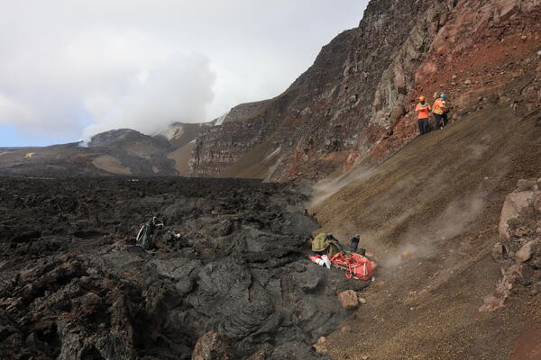
July 2, 2026 — Northwest wall of Halema‘uma‘u, Kīlauea summit
July 2, 2026 — Northwest wall of Halema‘uma‘u, Kīlauea summitOn July 2, three USGS Hawaiian Volcano Observatory scientists flew via helicopter to the northwest side of Halema‘uma‘u at the summit of Kīlauea to sample tephra deposits in the crater wall. These deposits were exposed by the 2018 summit collapse, but lava flows from the ongoing episodic Kīlauea summit eruption are likely to bury them again in the near future.
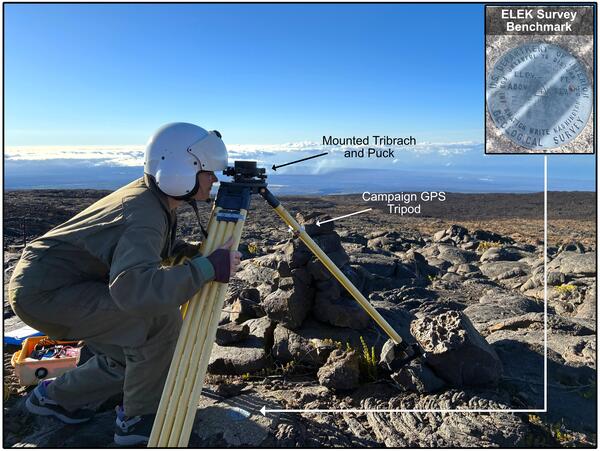
Geophysicist setting up GPS unit
Geophysicist sets up a campaign Global Positioning System (GPS) unit over benchmark ELEK, on the northeastern slope of Mauna Loa volcano. USGS photo.
Geophysicist sets up a campaign Global Positioning System (GPS) unit over benchmark ELEK, on the northeastern slope of Mauna Loa volcano. USGS photo.
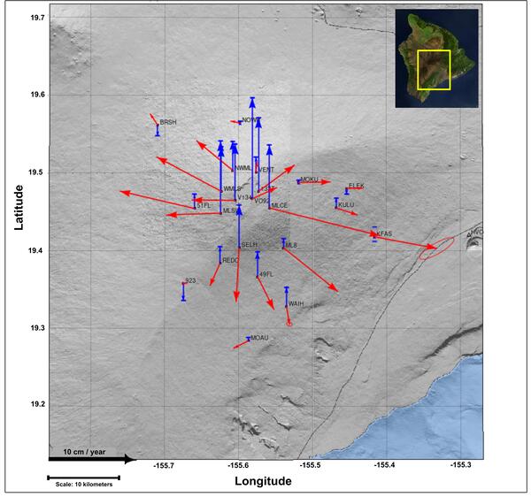
Mauna Loa GPS displacement field between 2025-2026
Mauna Loa GPS displacement field between 2025-2026Displacement field showing the horizontal (red arrows) and vertical (blue arrows) components of motion recorded by Global Positioning System (GPS) positions at each campaign benchmark site from surveys conducted between 2025-2026. The arrows point in the direction of motion and lengths represent how far positions were displaced over the past year.
June 30, 2026 — Looking down the north vent, Kīlauea summit
June 30, 2026 — Looking down the north vent, Kīlauea summitView looking down the north vent, taken during a USGS Hawaiian Volcano Observatory monitoring overflight on June 30, 2026. Glow and flames have been intermittently seen since episode 50 of lava fountaining in Halema‘uma‘u ended on June 27, 2026, but no glow was observed from the north or south vents during the overflight.
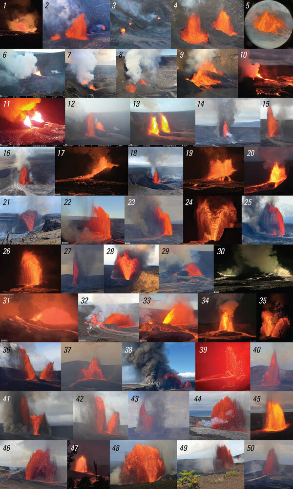
Photo compilation of lava fountaining episodes 1–50 of the ongoing eruption at the summit of Kīlauea
Photo compilation of lava fountaining episodes 1–50 of the ongoing eruption at the summit of KīlaueaPhoto compilation of lava fountaining episodes 1–50 in the ongoing eruption at the summit of Kīlauea, including webcam imagery and photos taken by USGS Hawaiian Volcano Observatory scientists on the ground and during helicopter overflights. In all photos except for episode 7, the south vent is on the left and the north vent is on the right.
June 30, 2026 — Looking to the east across Halemaʻumaʻu, Kīlauea summit
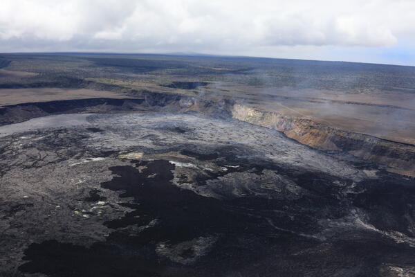
June 30, 2026 — Looking to the east across Halemaʻumaʻu, Kīlauea summitAerial photograph taken during a USGS Hawaiian Volcano Observatory monitoring overflight on June 30, 2026, looking to the east across lava flows that have accumulated in Halema‘uma‘u during the 50 lava fountaining episodes that have occurred since December 23, 2024. The black lava flows are rubbly ʻaʻā lava flows and the shiny, gray, smooth lava flows are pāhoehoe.
June 30, 2026 — Looking to the east across Halemaʻumaʻu, Kīlauea summit
June 30, 2026 — Looking to the east across Halemaʻumaʻu, Kīlauea summitAerial photograph taken during a USGS Hawaiian Volcano Observatory monitoring overflight on June 30, 2026, looking to the east across lava flows that have accumulated in Halema‘uma‘u during the 50 lava fountaining episodes that have occurred since December 23, 2024. The black lava flows are rubbly ʻaʻā lava flows and the shiny, gray, smooth lava flows are pāhoehoe.
June 30, 2026 — View to the south of Halemaʻumaʻu, Kīlauea summit
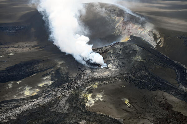
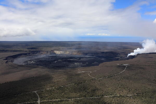
June 30, 2026 — View to the south of Halemaʻumaʻu, Kīlauea summitAerial photograph taken during a USGS Hawaiian Volcano Observatory monitoring overflight on June 30, 2026, to characterize the tephra and lava flows from Kīlauea summit fountaining episode 50 that occurred on June 27, 2026. The north and south vents have a robust plume coming from them with fresh black and gray lava flows covering much of Halema‘uma‘u crater floor.
June 30, 2026 — View to the south of Halemaʻumaʻu, Kīlauea summit
June 30, 2026 — View to the south of Halemaʻumaʻu, Kīlauea summitAerial photograph taken during a USGS Hawaiian Volcano Observatory monitoring overflight on June 30, 2026, to characterize the tephra and lava flows from Kīlauea summit fountaining episode 50 that occurred on June 27, 2026. The north and south vents have a robust plume coming from them with fresh black and gray lava flows covering much of Halema‘uma‘u crater floor.
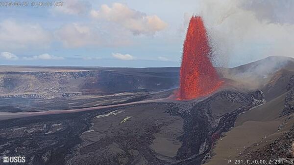
June 27, 2026 — Kīlauea episode 50 of lava fountaining from the V1cam
June 27, 2026 — Kīlauea episode 50 of lava fountaining from the V1camEpisode 50 of lava fountaining in Halemaʻumaʻu at the summit of Kīlauea took place for about 7 hours on June 27, 2026. This photograph of the episode was taken by the V1cam, located on the northwest rim of the crater in Hawaiʻi Volcanoes National Park. USGS webcam image.