
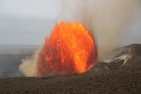
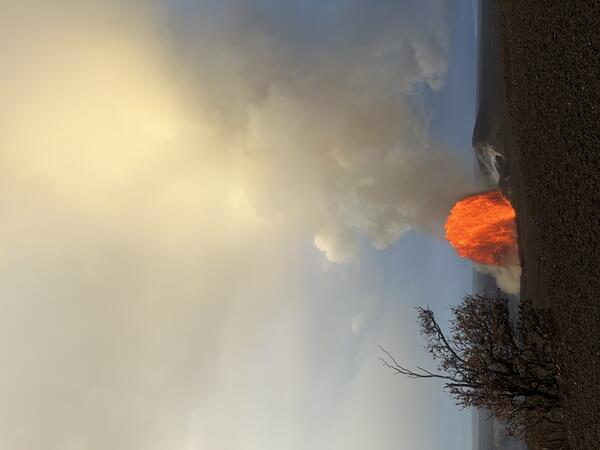
This photo of the Halema‘uma‘u north vent lava fountain was captured shortly after sunrise on June 1, 2026, around the time that activity was peaking during Kīlauea summit eruption fountaining episode 48. Preliminary estimates indicate that the lava fountain reached at least 500 feet (150 meters) in height during the episode.
Images
Hawaiian Volcano Observatory images of eruptive activity, field work, and more.
Filter Total Items: 4072
June 1, 2026 — Episode 48 lava fountain at dawn
This photo of the Halema‘uma‘u north vent lava fountain was captured shortly after sunrise on June 1, 2026, around the time that activity was peaking during Kīlauea summit eruption fountaining episode 48. Preliminary estimates indicate that the lava fountain reached at least 500 feet (150 meters) in height during the episode.
June 1, 2026 — Episode 48 north vent fountain
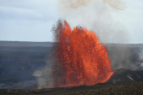
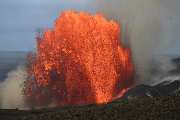
During episode 48 of lava fountaining at the summit of Kīlauea on June 1, 2026, the lava fountain from the north vent reached a maximum height of almost 650 ft (200 m) at its peak around 6:30 a.m. HST. This photo was taken at 8:00 a.m. HST, nearly an hour and a half later, and shows a fountain of around 500 ft (152.5 m). USGS photo by L. Gallant.
During episode 48 of lava fountaining at the summit of Kīlauea on June 1, 2026, the lava fountain from the north vent reached a maximum height of almost 650 ft (200 m) at its peak around 6:30 a.m. HST. This photo was taken at 8:00 a.m. HST, nearly an hour and a half later, and shows a fountain of around 500 ft (152.5 m). USGS photo by L. Gallant.
June 1, 2026 — Episode 48 lava fountain and rainbow
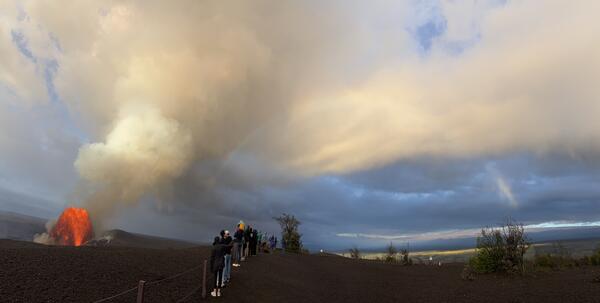
June 1, 2026 — Episode 48 lava fountain and rainbowVisitors at Uēkahuna overlook in Hawaiʻi Volcanoes National Park at approximately 6:30 a.m. HST on June 1, 2026, viewed lava fountaining from the north vent during episode 48 of the ongoing Kīlauea summit eruption, framed by a rainbow. USGS photo by L. Gallant.
June 1, 2026 — Episode 48 lava fountain and rainbow
June 1, 2026 — Episode 48 lava fountain and rainbowVisitors at Uēkahuna overlook in Hawaiʻi Volcanoes National Park at approximately 6:30 a.m. HST on June 1, 2026, viewed lava fountaining from the north vent during episode 48 of the ongoing Kīlauea summit eruption, framed by a rainbow. USGS photo by L. Gallant.
June 1, 2026 — Episode 48 lava fountain within Halemaʻumaʻu at Kīlauea summit
June 1, 2026 — Episode 48 lava fountain within Halemaʻumaʻu at Kīlauea summitEpisode 48 lava fountain from the north vent in Halemaʻumaʻu crater, at the summit of Kīlauea volcano, as viewed from near Uēkahuna overlook in Hawaiʻi Volcanoes National Park. USGS photo by M. Decker.
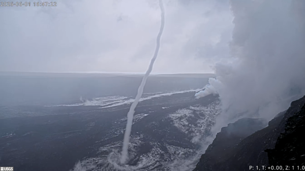
June 1, 2026 — Whirlwind after episode 48 of lava fountaining at Kīlauea summit
June 1, 2026 — Whirlwind after episode 48 of lava fountaining at Kīlauea summitRain at Kīlauea summit following nine hours of lava fountaining during episode 48 on June 1, 2026, created steamy conditions within Halemaʻumaʻu, the crater floor of which was 40% covered with new lava flows during the episode. In the V1cam, a prominent whirlwind (puahiohio in ʻŌlelo Hawaiʻi, or the Hawaiian language) was visible forming at 4:47 p.m.
June 1, 2026 — Episode 48 north vent lava fountain
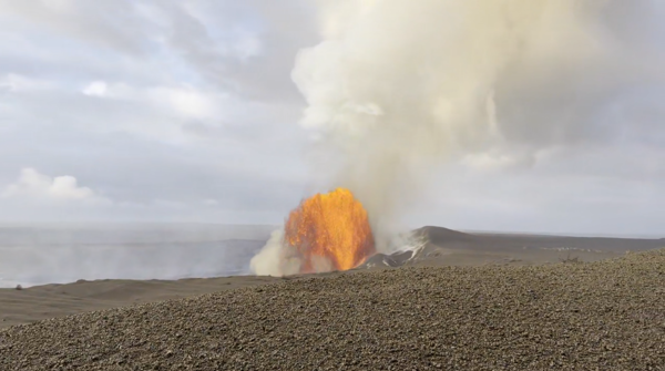
June 1, 2026 — Episode 48 north vent lava fountainEpisode 48 of lava fountaining in the ongoing eruption at Kīlauea summit started on June 1, 2026, at 4:40 a.m. HST. This photo was taken shortly after 6 a.m. from Uēkahuna overlook in Hawai‘i Volcanoes National Park, and shows the north vent lava fountain.
June 1, 2026 — Episode 48 north vent lava fountain
June 1, 2026 — Episode 48 north vent lava fountainEpisode 48 of lava fountaining in the ongoing eruption at Kīlauea summit started on June 1, 2026, at 4:40 a.m. HST. This photo was taken shortly after 6 a.m. from Uēkahuna overlook in Hawai‘i Volcanoes National Park, and shows the north vent lava fountain.
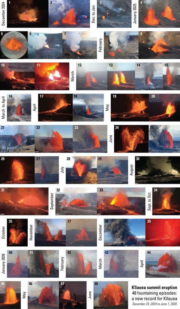
Photo compilation of Kīlauea's record breaking 48 lava fountaining episodes
Photo compilation of Kīlauea's record breaking 48 lava fountaining episodesPhoto calendar compilation of the 48 lava fountaining episodes that have occurred at Kīlauea's summit eruption. The eruption started on December 23, 2024, and episode 48 occurred on June 1, 2026.

June 1, 2026 — Episode 48 tephra fall downwind
About 5 miles (8 km) east northeast of the eruption location in Halemaʻumaʻu crater at the summit of Kīlauea, ash and Pele's hair accumulated on the hood of a white vehicle during episode 48 of lava fountaining on June 1, 2026.
About 5 miles (8 km) east northeast of the eruption location in Halemaʻumaʻu crater at the summit of Kīlauea, ash and Pele's hair accumulated on the hood of a white vehicle during episode 48 of lava fountaining on June 1, 2026.
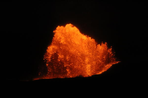
June 1, 2026 — Episode 48 lava fountain at night
In the early morning hours of June 1, 2026, USGS Hawaiian Volcano Observatory scientists reported to Uēkahuna to watch the beginning of Kīlauea summit eruption fountaining episode 48. The fountaining episode began at 4:40 a.m. HST and by the time the scientists arrived around 5:00 a.m.
In the early morning hours of June 1, 2026, USGS Hawaiian Volcano Observatory scientists reported to Uēkahuna to watch the beginning of Kīlauea summit eruption fountaining episode 48. The fountaining episode began at 4:40 a.m. HST and by the time the scientists arrived around 5:00 a.m.
June 1, 2026 — Episode 48 lava fountain
Lava fountains of episode 48 started at 4:40 a.m. HST from the north vent in Halema‘uma‘u crater at the summit of Kīlauea volcano. Lava fountains have reached a maximum height of almost 650 ft (200 m) at their peak, shown here in a photo taken at 06:19 a.m. HST. USGS photo by L. Gallant.
Lava fountains of episode 48 started at 4:40 a.m. HST from the north vent in Halema‘uma‘u crater at the summit of Kīlauea volcano. Lava fountains have reached a maximum height of almost 650 ft (200 m) at their peak, shown here in a photo taken at 06:19 a.m. HST. USGS photo by L. Gallant.
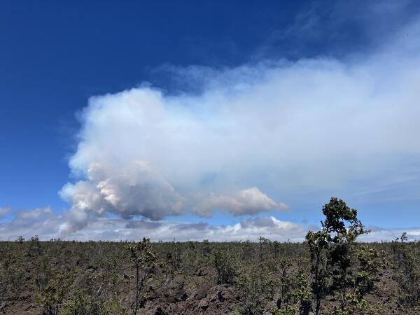
June 27, 2026 — Episode 50 plume from Footprints Trail
June 27, 2026 — Episode 50 plume from Footprints TrailOn June 27, 2026, steady trade winds blew the plume from Kīlauea summit eruption episode 50 to the southwest of Halema‘uma‘u.
June 27, 2026 — Episode 50 plume from Footprints Trail
June 27, 2026 — Episode 50 plume from Footprints TrailOn June 27, 2026, steady trade winds blew the plume from Kīlauea summit eruption episode 50 to the southwest of Halema‘uma‘u.
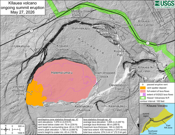
May 27, 2026—Kīlauea summit eruption reference map
May 27, 2026—Kīlauea summit eruption reference mapThis reference map depicts the Kīlauea summit eruption within Halema‘uma‘u crater that began on December 23, 2024. Most of the data for this map were collected during a USGS Hawaiian Volcano Observatory helicopter overflight on May 22, 2026, so the provided statistics are reflective of the entire eruption through episode 47 on May 14–15.
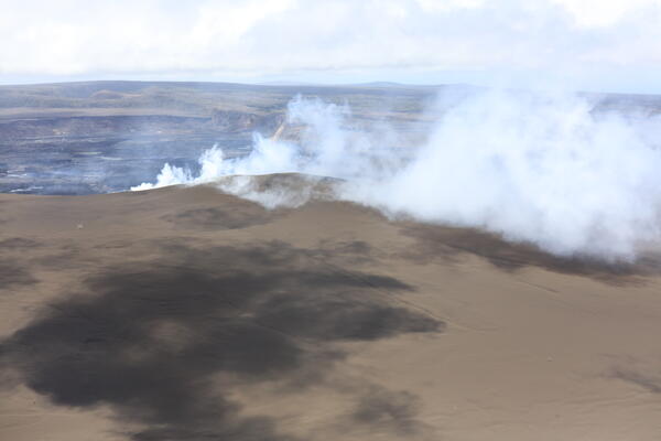
May 22, 2026 — View of cone and degassing north and south vents at Kīlauea summit
May 22, 2026 — View of cone and degassing north and south vents at Kīlauea summitAn aerial view from the west side of Halemaʻumaʻu shows the 150-foot (45 meter) high tephra cone that has formed on the rim of the crater during the 2024–ongoing eruption at the summit of Kīlauea. Gas emitted from the north and south vents, not currently erupting, is visible wafting over the rim of the crater. USGS photo by D. Downs.
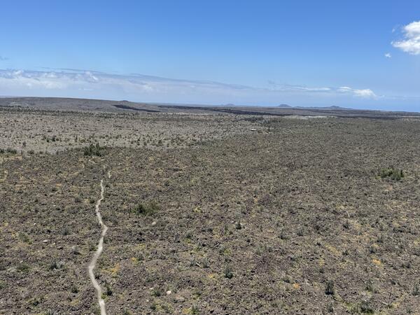
May 22, 2026 — Maunaiki shield and Kaʻū Desert trail on the Southwest Rift Zone of Kīlauea
May 22, 2026 — Maunaiki shield and Kaʻū Desert trail on the Southwest Rift Zone of KīlaueaAs USGS Hawaiian Volcano Observatory traversed under the volcanic plume from Kīlauea summit where it was transported downwind into the Kaʻū Desert area of Hawaiʻi Volcanoes National Park, they captured this view of the Maunaiki shield and Kaʻū Desert trail.
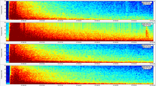
Spectrogram data from the magnitude-6 earthquake beneath the Island of Hawaiʻi on May 22, 2026
Spectrogram data from the magnitude-6 earthquake beneath the Island of Hawaiʻi on May 22, 2026Spectrogram data associated with the magnitude-6 earthquake beneath the Island of Hawaiʻi on May 22, 2026, collected by four seismometers at different locations on the Island of Hawaiʻi. Spectrograms show the frequency spectrum recorded by a seismometer over time. USGS plot.
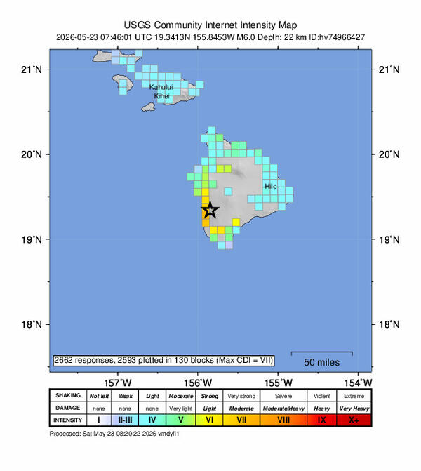
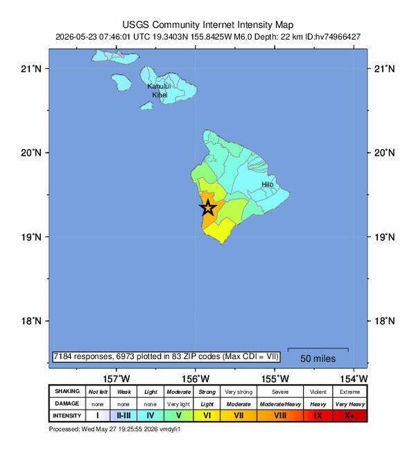
Shaking intensity of the magnitude-6 earthquake beneath the Island of Hawaiʻi on May 22, 2026
Shaking intensity of the magnitude-6 earthquake beneath the Island of Hawaiʻi on May 22, 2026Map showing the shaking intensity of the magnitude-6 earthquake beneath the Island of Hawaiʻi on May 22, 2026, derived from community reports submitted to the USGS “Did you feel it?” website.
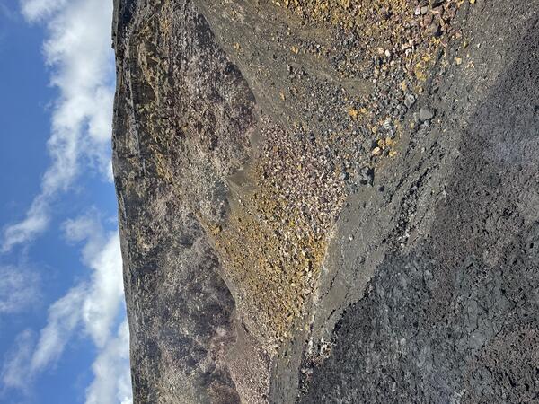
May 22, 2026 — View of altered Halemaʻumaʻu crater wall at Kīlauea summit
May 22, 2026 — View of altered Halemaʻumaʻu crater wall at Kīlauea summitA view of Halemaʻumaʻu crater wall near the south sulphur bank area, where the basalt has been altered and weathered by long-term degassing in this area, causing the pastel colors of discoloration.
Shaking intensity map of the magnitude-6 earthquake beneath the Island of Hawaiʻi on May 22, 2026
Shaking intensity map of the magnitude-6 earthquake beneath the Island of Hawaiʻi on May 22, 2026Map showing the shaking intensity of the magnitude-6 earthquake beneath the Island of Hawaiʻi on May 22, 2026, derived from community reports submitted to the USGS “Did you feel it?” website.
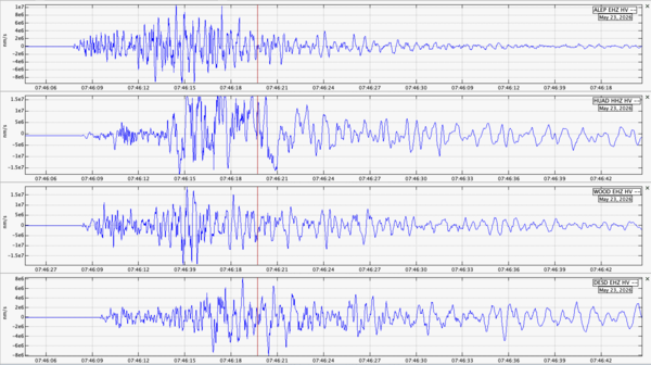
Waveforms from the magnitude-6 earthquake beneath the Island of Hawaiʻi on May 22, 2026
Waveforms from the magnitude-6 earthquake beneath the Island of Hawaiʻi on May 22, 2026Seismic waveform data associated with the magnitude-6 earthquake beneath the Island of Hawaiʻi on May 22, 2026, collected by four seismometers at different locations on the Island of Hawaiʻi. USGS plot.
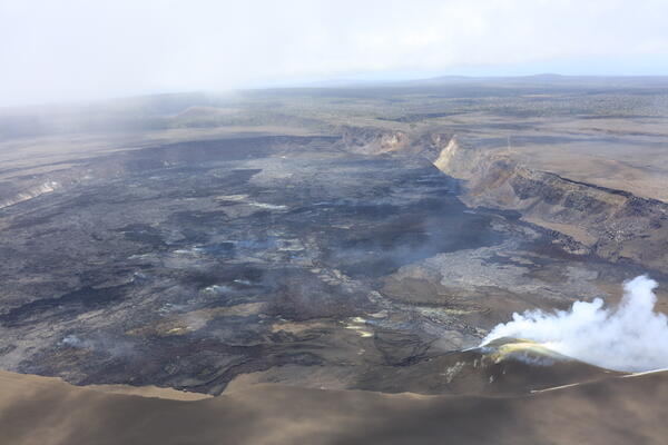
May 22, 2026 — Halemaʻumaʻu crater and degassing vents at Kīlauea summit
May 22, 2026 — Halemaʻumaʻu crater and degassing vents at Kīlauea summitUSGS Hawaiian Volcano Observatory scientists conducted a monitoring overflight of Kīlauea summit the morning of May 22, 2026. During the overflight, they collected imagery to create a three-dimensional model of the crater floor, thermal imagery to determine the extent of episode 47 lava flows, and traversed beneath the volcanic plume to measure emission rates.
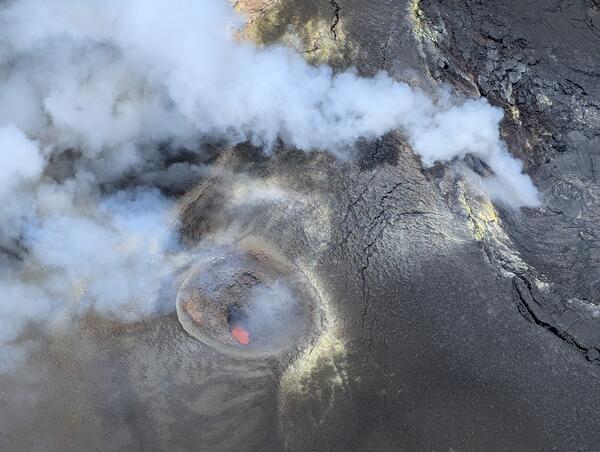
May 22, 2026 — View into the south vent at Kīlauea summit
May 22, 2026 — View into the south vent at Kīlauea summitDuring a monitoring overflight on May 22, 2026, USGS Hawaiian Volcano Observatory scientists captured this aerial view looking down into the south vent in Halemaʻumaʻu at the summit of Kīlauea. Magma was visible within both the south and north vents during the overflight; the north vent is visible degassing on the right side of this image.