
Logo for the Volcano Minute, a brief audio update about eruptions, earthquakes, or ongoing volcano science in Hawaii brought to you by scientists and affiliates of the U.S. Geological Survey Hawaiian Volcano Observatory.
Images
Hawaiian Volcano Observatory images of eruptive activity, field work, and more.
Filter Total Items: 4072
Volcano Minute Logo
Logo for the Volcano Minute, a brief audio update about eruptions, earthquakes, or ongoing volcano science in Hawaii brought to you by scientists and affiliates of the U.S. Geological Survey Hawaiian Volcano Observatory.
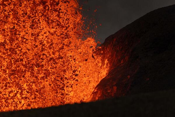
June 14, 2026 — Kīlauea north vent base during episode 49
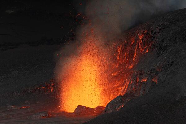
June 14, 2026 — Kīlauea north vent base during episode 49This telephoto view of the north vent lava fountain during episode 49 on June 14. 2026, shows the incandescent lava landing on and illuminating the Halema‘uma‘u crater wall. USGS photo by T. Paladino.
June 14, 2026 — Kīlauea north vent base during episode 49
June 14, 2026 — Kīlauea north vent base during episode 49This telephoto view of the north vent lava fountain during episode 49 on June 14. 2026, shows the incandescent lava landing on and illuminating the Halema‘uma‘u crater wall. USGS photo by T. Paladino.
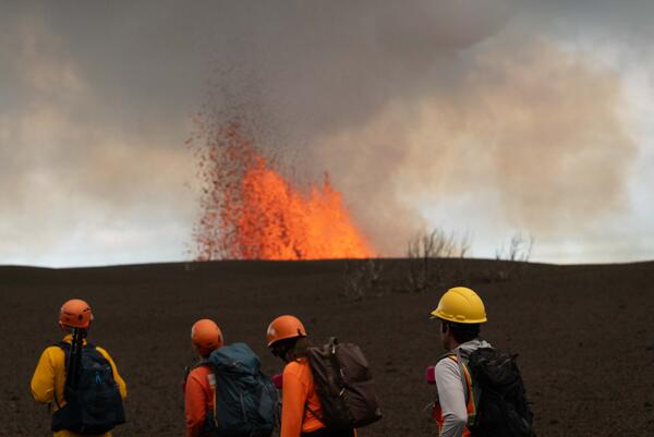
June 14, 2026 — Monitoring Kīlauea eruption episode 49
June 14, 2026 — Monitoring Kīlauea eruption episode 49USGS scientists traverse the tephra deposit from the ongoing Kīlauea summit eruption in Halema‘uma‘u on June 14, 2026, to collect real-time measurements of lava fountain heights, tephra dispersal, and crater floor coverage during episode 49.
June 14, 2026 — Monitoring Kīlauea episode 49
During lava fountaining episodes at the summit of Kīlauea, USGS Hawaiian Volcano Observatory scientists use laser rangefinders to estimate high how the lava fountains are reaching above the vents and how far the lava flows have traveled from the vents. Additionally, they document eruption dynamics and record eruptive activity using high-resolution cameras.
During lava fountaining episodes at the summit of Kīlauea, USGS Hawaiian Volcano Observatory scientists use laser rangefinders to estimate high how the lava fountains are reaching above the vents and how far the lava flows have traveled from the vents. Additionally, they document eruption dynamics and record eruptive activity using high-resolution cameras.
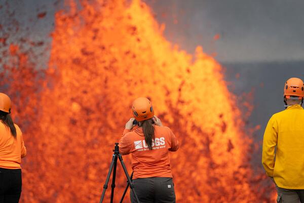
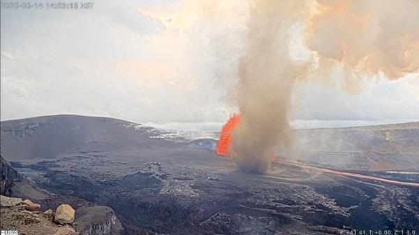
June 14, 2026 — Kīlauea summit eruption episode 49
June 14, 2026 — Kīlauea summit eruption episode 49An overview of episode 49 of lava fountaining during the ongoing Kīlauea summit eruption in Halema‘uma‘u, taken from Kīlauea overlook in Hawai‘i Volcanoes National Park. Fountains reached a maximum height of approximately 210 m (688 ft), but because of wind patterns, little to no tephra was deposited in the public viewing areas of the national park.
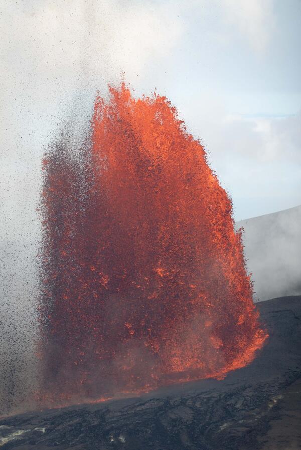
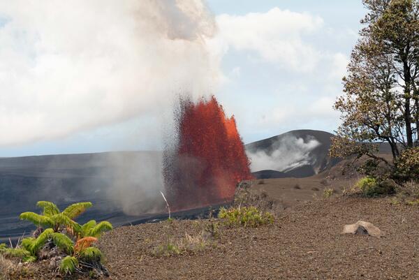
June 14, 2026 — Kīlauea episode 49 lava fountain from the north vent
June 14, 2026 — Kīlauea episode 49 lava fountain from the north ventEpisode 49 of the Kīlauea summit eruption in Halema‘uma‘u started at 9:36 a.m. HST on June 14, 2026, and lasted approximately 7.5 hours. Only north vent erupted a lava fountain, which reached a maximum height of about 210 m (688 ft). USGS photo by T. Paladino.
June 14, 2026 — Episode 49 at the summit of Kīlauea as it was ending
June 14, 2026 — Episode 49 at the summit of Kīlauea as it was endingEpisode 49 of the Kīlauea summit eruption in Halema‘uma‘u ended abruptly by 5:05 p.m. HST on June 14, after 7.5 hours of lava fountaining activity from the north vent. The final waning stage of fountaining activity lasted less than 5 minutes, during which the lava fountain dropped below 60-80 meters (200-260 ft) in height.
June 14, 2026 — Kīlauea episode 49 fountain and dust devil visible from V3cam
June 14, 2026 — Kīlauea episode 49 fountain and dust devil visible from V3camThis photograph, taken just after 2 p.m. HST on June 14, 2026, shows a dust devil, or puahiohio, forming within Halemaʻumaʻu crater at the summit of Kīlauea during lava fountaining episode 49. USGS photo.
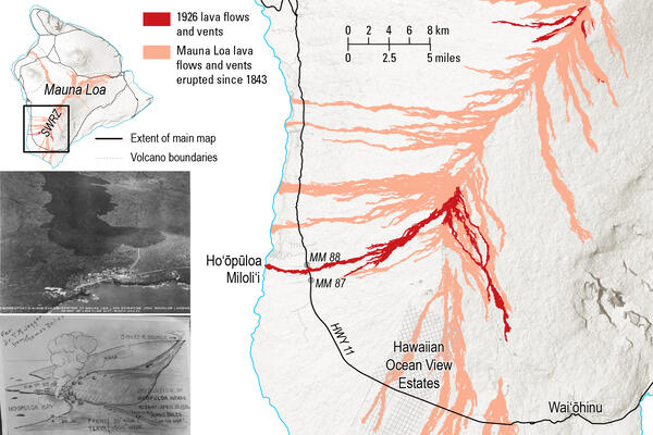
Map of the 1926 Mauna Loa lava flows (red), with all Mauna Loa lava flows since 1843 shown in peach.
Map of the 1926 Mauna Loa lava flows (red), with all Mauna Loa lava flows since 1843 shown in peach.Map of the 1926 Mauna Loa lava flows (red), with all Mauna Loa lava flows since 1843 shown in peach. The eruption started at the summit (top right of main map) on April 10.
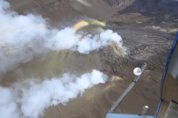
June 9, 2026 — Aerial view into the eruptive vents in Halemaʻumaʻu at the summit of Kīlauea
June 9, 2026 — Aerial view into the eruptive vents in Halemaʻumaʻu at the summit of KīlaueaUSGS scientists conduct Kīlauea summit monitoring overflight on June 9, 2026, to document changes to the eruptive vents and crater floor after episode 48 that took place on June 1.
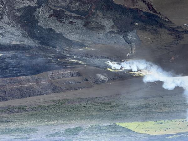
June 9, 2026 — Aerial overview of the eruptive vents at the summit of Kīlauea
June 9, 2026 — Aerial overview of the eruptive vents at the summit of KīlaueaAerial photograph showing the eruptive vents in Halema‘uma‘u crater at the summit of Kīlauea during a USGS Hawaiian Volcano Observatory monitoring overflight on June 9, 2026. Erupted material (lava flows and tephra) continues to build up the base of the vents, and sulfur precipitation is present on the vent walls (yellow patches). USGS photo by H. Winslow.
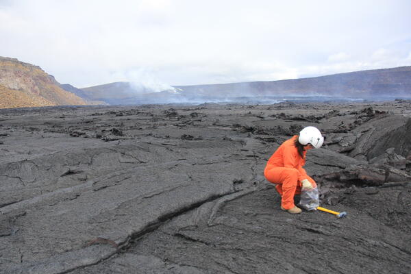
June 9, 2026 — Collecting Kīlauea episode 48 lava sample
June 9, 2026 — Collecting Kīlauea episode 48 lava sampleHalema‘uma‘u is a culturally significant location, being the home of Pele—the Native Hawaiian deity associated with lava. USGS scientists access this area of Kīlauea summit with permission from Hawai‘i Volcanoes National Park. On June 9, 2026, USGS scientists landed on the Halema‘uma‘u crater floor to collect lava flow samples from episode 48.
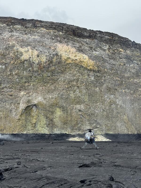
June 9, 2026 — South sulphur bank at the summit of Kīlauea
June 9, 2026 — South sulphur bank at the summit of KīlaueaOn June 9, 2026, USGS-Hawaiian Volcano Observatory scientists landed on the floor of Halema'uma'u crater in the vicinity of the south sulphur bank, visible in the background of this photo. The south sulphur bank was prominently visible in the mid-19th century but was covered as lava flows filled the caldera and wasn't visible in the twentieth century.
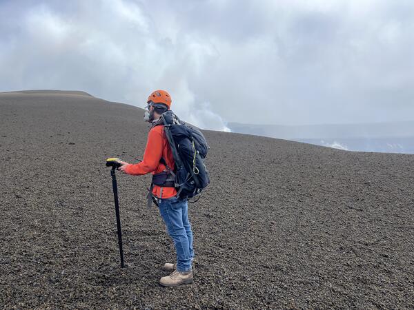
June 5, 2026 — Scientist measures changes in elevation across the new pu‘u at Kīlauea after episode 48
June 5, 2026 — Scientist measures changes in elevation across the new pu‘u at Kīlauea after episode 48A USGS Hawaiian Volcano Observatory geologist surveys the elevation at a point along a transect across the new Pu‘u, formed from tephra fallout from the ongoing eruption at Kīlauea's summit. At each repeat measurement site, data is collected for at least 4 minutes. The geologist is on the south side of the Pu‘u and is looking north towards its summit.
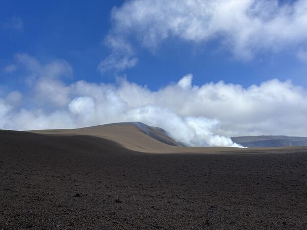
June 5, 2026 — View of cone forming behind north and south vents at Kīlauea summit
June 5, 2026 — View of cone forming behind north and south vents at Kīlauea summitThis view is of the cone (pu‘u) that has formed in the predominant downwind direction (southwest) of the north and south vents during the ongoing eruption at Halema‘uma‘u at the summit of Kīlauea. This photo is south of the southwest corner of Halema‘uma‘u and is looking to the north-northwest.
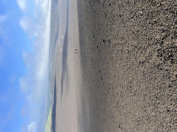
June 5, 2026 — Measuring changes in elevation across the new pu‘u at Kīlauea after episode 48
June 5, 2026 — Measuring changes in elevation across the new pu‘u at Kīlauea after episode 48For over a year, after each fountaining episode at Kīlauea's summit, USGS Hawaiian Volcano Observatory geologists have surveyed the elevation along a transect across the new pu‘u on the western margin of Halema‘uma‘u. These repeat measurements across the same set of points, spaced about 330 feet (100 meters) apart, track the growth and changes of the pu‘u.
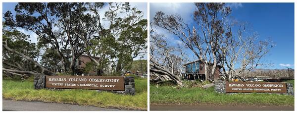
Changes in vegetation near the Hawaiian Volcano Observatory sign
Changes in vegetation near the Hawaiian Volcano Observatory signBefore and after photos of vegetation defoliation outside the new USGS Hawaiian Volcano Observatory Field Station building located near the Kilauea Military Camp inside Hawaiʻi Volcanoes National Park. Left photo was taken on February 11, 2026. Right photo was taken on April 21, 2026. USGS photos by K. Mulliken.
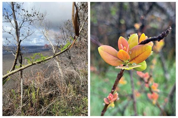
Renewed vegetation growth at Kīlauea summit
Signs of renewed growth on vegetation in areas hit hard by recent storm and volcanic impacts in the Kīlauea Summit region. Photos courtesy of Pete Lockhart and Jill Briggs.
Signs of renewed growth on vegetation in areas hit hard by recent storm and volcanic impacts in the Kīlauea Summit region. Photos courtesy of Pete Lockhart and Jill Briggs.
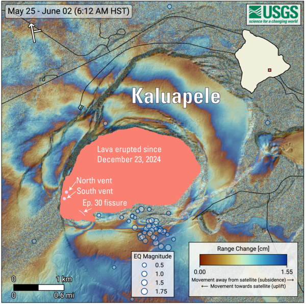
June 2, 2026—InSAR image of Kīlauea deformation associated with episode 48 of ongoing summit eruption
June 2, 2026—InSAR image of Kīlauea deformation associated with episode 48 of ongoing summit eruptionCOSMO-SkyMed Second Generation (CSG) interferogram for the period from May 25 to June 2, 2026, covering Kīlauea volcano’s summit region.
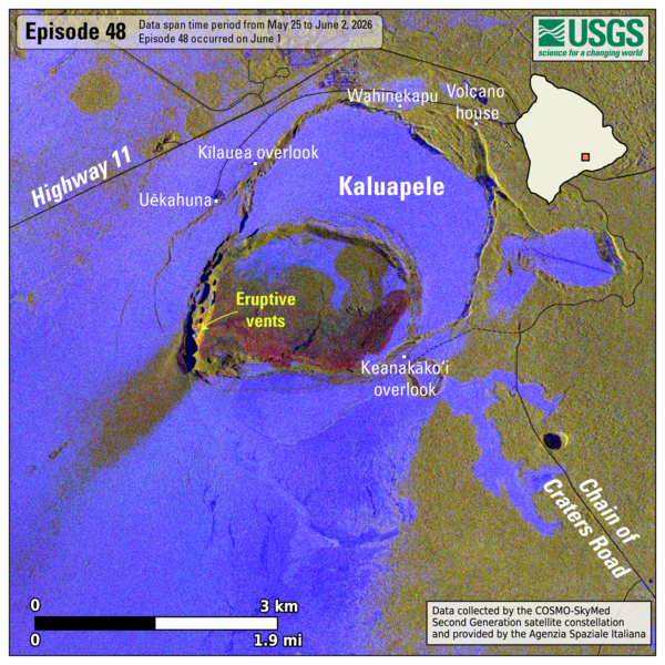
June 2, 2026 — Kīlauea lava flow and tephra fall map following episode 48
June 2, 2026 — Kīlauea lava flow and tephra fall map following episode 48This map shows lava flow and tephra accumulation at the summit of Kīlauea volcano associated with episode 48 of the ongoing eruption in Halemaʻumaʻu that started on December 23, 2024, using data recorded by the Italian Space Agency's (ASI) COSMO-SkyMed Second Generation satellite constellation.
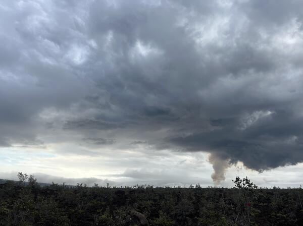
June 1, 2026 — View of episode 48 lava fountain and plume from near the Ka‘ū Desert trailhead
June 1, 2026 — View of episode 48 lava fountain and plume from near the Ka‘ū Desert trailheadThis photo was taken from near the Ka‘ū Desert trailhead within Hawai‘i Volcanoes National Park on June 1, 2026, during episode 48 of lava fountaining at Kīlauea summit. It shows the top of the north vent lava fountain on the skyline to the right and the volcanic plume rising above it.