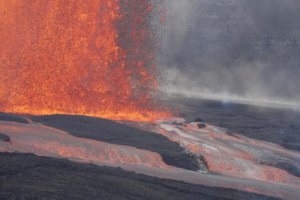
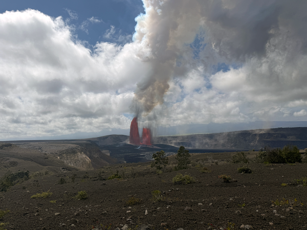
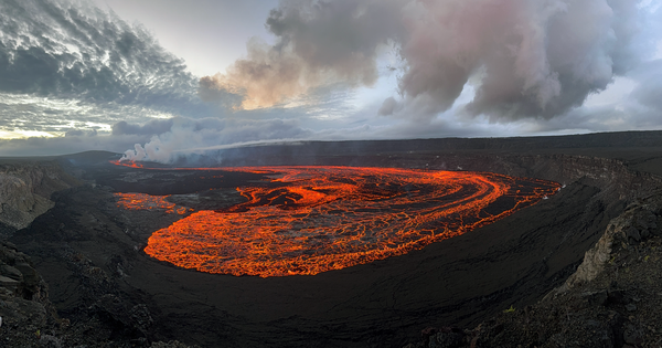
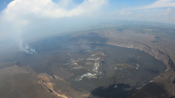
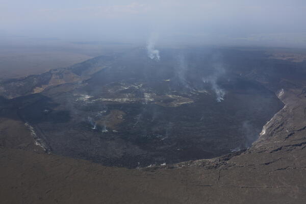
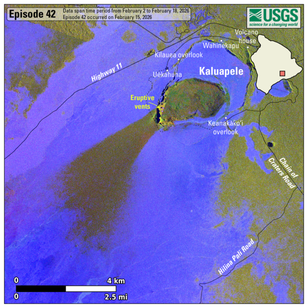
U.S. flag

An official website of the United States government

Images

Hawaiian Volcano Observatory images of eruptive activity, field work, and more.

Filter Total Items: 3757
Color photograph of lava fountain
July 9, 2025 — Lava fountaining during episode 28 at Kīlauea

At approximately 6:30 a.m. on July 9, the sunrise illuminated the walls of Kaluapele, as the north vent remained in the shadows of the caldera walls. USGS photo by K. Mulliken.

At approximately 6:30 a.m. on July 9, the sunrise illuminated the walls of Kaluapele, as the north vent remained in the shadows of the caldera walls. USGS photo by K. Mulliken.

Color photograph of lava fountain
July 9, 2025 — Episode 28 of the Halema‘uma‘u Kīlauea summit eruption

Lava fountaining associated with episode 28 of the ongoing Halemaʻumaʻu eruption began at 4:10 a.m. HST on July 9,  following several days of gas pistoning cycles, some of which produced small lava overflows at the north vent on July 8. USGS photo by L. Gallant. 

Lava fountaining associated with episode 28 of the ongoing Halemaʻumaʻu eruption began at 4:10 a.m. HST on July 9,  following several days of gas pistoning cycles, some of which produced small lava overflows at the north vent on July 8. USGS photo by L. Gallant. 

Color photograph of lava fountain and eruption plume
July 9, 2025 — Episode 28 Halema‘uma‘u lava fountain and eruption plume at Kīlauea summit

Episode 28 of the ongoing Halemaʻumaʻu eruption began just after 4 a.m. HST on July 9, 2025. This photograph was taken from the north rim of the caldera around 6:30 a.m., as Hawaiʻi Volcanoes National Park visitors gathered to view the episode. USGS photo by K. Mulliken.

Episode 28 of the ongoing Halemaʻumaʻu eruption began just after 4 a.m. HST on July 9, 2025. This photograph was taken from the north rim of the caldera around 6:30 a.m., as Hawaiʻi Volcanoes National Park visitors gathered to view the episode. USGS photo by K. Mulliken.

Color panoramic photo of a volcanic caldera with eruption
July 9, 2025 — Panoramic image showing episode 28 of Halema‘uma‘u eruption within Kaluapele

This panoramic image, taken around 6:30 a.m. HST on July 9, 2025, shows episode 28 of the ongoing eruption in Halemaʻumaʻu crater, within Kaluapele (the summit caldera of Kīlauea volcano). This view, from the north rim of the caldera, shows that the ongoing eruption has been occurring in the southwest part of the caldera. USGS photo by K. Mulliken. 

This panoramic image, taken around 6:30 a.m. HST on July 9, 2025, shows episode 28 of the ongoing eruption in Halemaʻumaʻu crater, within Kaluapele (the summit caldera of Kīlauea volcano). This view, from the north rim of the caldera, shows that the ongoing eruption has been occurring in the southwest part of the caldera. USGS photo by K. Mulliken. 

Color photograph of volcanic material deposited on landscape
July 9, 2025 — View of the growing tephra hill after episode 28 at Kīlauea

After episode 28 ended, USGS geologists inspected the tephra deposit southwest of the eruptive vents, in the closed area of Hawai‘i Volcanoes National Park. The tephra continues to accumulate and build up a hill that is more than 80 ft (~25 m) high, covering parts of Crater Rim Drive.

After episode 28 ended, USGS geologists inspected the tephra deposit southwest of the eruptive vents, in the closed area of Hawai‘i Volcanoes National Park. The tephra continues to accumulate and build up a hill that is more than 80 ft (~25 m) high, covering parts of Crater Rim Drive.

Color photograph of lava fountain in crater
July 9, 2025 – Aerial view of episode 28 of Halema‘uma‘u Kīlauea summit eruption

In this view from an eruption monitoring helicopter overflight on Wednesday, July 9, new lava flows can be seen traveling across the Halema‘uma‘u crater floor—these appear as fluid forms with a shiny, silvery crust over incandescent red-hot lava. Older lava flows from previous eruptive episodes have a darker or duller appearance.

In this view from an eruption monitoring helicopter overflight on Wednesday, July 9, new lava flows can be seen traveling across the Halema‘uma‘u crater floor—these appear as fluid forms with a shiny, silvery crust over incandescent red-hot lava. Older lava flows from previous eruptive episodes have a darker or duller appearance.

Color photographs showing volcano monitoring equipment covered with tephra
July 1, 2025 — Volcano monitoring equipment covered with tephra after episode 27 lava fountaining at Kīlauea

Following episode 27 of the Kīlauea summit eruption on June 29, USGS Hawaiian Volcano Observatory field engineers visited several sites southwest of Halemaʻumaʻu on July 1 to remove tephra that had accumulated on the solar panels and station infrastructure. USGS photos by M. Warren. 

Color photograph of altered rock and steaming ground
Ha‘akulamanu
Ha‘akulamanu
Ha‘akulamanu

The Ha‘akulamanu trail within Hawai‘i Volcanoes National Park passes through the Sulphur Banks area, where long-term degassing near Kaluapele (Kīlauea summit caldera) has altered the basalt to colorful minerals including yellow sulfur, white gypsum, and reddish-brown hematite. USGS photo by C. Sealing.

The Ha‘akulamanu trail within Hawai‘i Volcanoes National Park passes through the Sulphur Banks area, where long-term degassing near Kaluapele (Kīlauea summit caldera) has altered the basalt to colorful minerals including yellow sulfur, white gypsum, and reddish-brown hematite. USGS photo by C. Sealing.

Color photograph annotated with video title
30 episodes of lava fountaining at Kīlauea video thumbnail

Since December 23, 2024, 30 episodes of lava fountaining have happened in summit caldera of Kīlauea volcano, in Hawaiʻi Volcanoes National Park. 

Color photograph of people sitting on the ground with an eruption visible in the background
June 29, 2025 — Episode 27 at the summit of Kīlauea

Visitors near the Keanakākoʻi Overlook in Hawaiʻi Volcanoes National Park view lava fountaining during episode 27 of the ongoing Kīlauea summit eruption on June 29. Approximately 1.6 billion gallons (8.1 million cubic yards, 6.2 million cubic meters) of lava erupted during the sustained fountaining phase of episode 27.

Visitors near the Keanakākoʻi Overlook in Hawaiʻi Volcanoes National Park view lava fountaining during episode 27 of the ongoing Kīlauea summit eruption on June 29. Approximately 1.6 billion gallons (8.1 million cubic yards, 6.2 million cubic meters) of lava erupted during the sustained fountaining phase of episode 27.

Color photograph showing plant and lava fountain in the background
June 29, 2025 — Kīlauea episode 27 lava fountain and ʻōhiʻa lehua

Episode 27 lava fountains at the summit of Kīlauea occurred over about 11 hours on Sunday, June 29. In this view, the vibrant red lehua blossoms of the native ʻōhia tree frame the foreground, while the lava fountain from the north vent is visible in the background.  USGS photo by P. Dotray.

Episode 27 lava fountains at the summit of Kīlauea occurred over about 11 hours on Sunday, June 29. In this view, the vibrant red lehua blossoms of the native ʻōhia tree frame the foreground, while the lava fountain from the north vent is visible in the background.  USGS photo by P. Dotray.

Color photograph of lava fountain
June 29, 2025 — Kīlauea lava fountain and koaʻe kea

A koaʻe kea (white-tailed tropicbird) flies near the lava fountain during episode 27 of the ongoing Kīlauea summit eruption in Halemaʻumaʻu. These birds are often visible in the vicinity of Kaluapele (Kīlauea summit caldera), as they nest in the walls of the caldera. USGS photo by K. Mulliken. 

A koaʻe kea (white-tailed tropicbird) flies near the lava fountain during episode 27 of the ongoing Kīlauea summit eruption in Halemaʻumaʻu. These birds are often visible in the vicinity of Kaluapele (Kīlauea summit caldera), as they nest in the walls of the caldera. USGS photo by K. Mulliken. 

Lava fountains in the background with visitors visible in the foreground
June 29, 2025 — Kīlauea summit episode 27

From the south rim of Kaluapele (Kīlauea summit caldera), the growing tephra cone downwind of the ongoing eruption site in Halemaʻumaʻu is easily visible. On June 29, visitors gathered along the rim near Keanakākoʻi Overlook within Hawaiʻi Volcanoes National Park to view lava fountaining associated with episode 27. USGS photo by K. Mulliken. 

From the south rim of Kaluapele (Kīlauea summit caldera), the growing tephra cone downwind of the ongoing eruption site in Halemaʻumaʻu is easily visible. On June 29, visitors gathered along the rim near Keanakākoʻi Overlook within Hawaiʻi Volcanoes National Park to view lava fountaining associated with episode 27. USGS photo by K. Mulliken. 

Color photograph of lava fountains
June 29, 2025 — Episode 27 of the Halema‘uma‘u Kīlauea summit eruption

Episode 27 of the Halema‘uma‘u Kīlauea summit eruption began around 9:05 a.m. HST on June 29, 2025. The north vent was active for majority of the eruption and reached approximately 1115 ft (~340 m) high by 11:00 am HST. The south vent became active with low level fountaining of about 65 ft (20 m) just before 4:00 p.m. HST. The fountains lasted just under 11 hours.

Episode 27 of the Halema‘uma‘u Kīlauea summit eruption began around 9:05 a.m. HST on June 29, 2025. The north vent was active for majority of the eruption and reached approximately 1115 ft (~340 m) high by 11:00 am HST. The south vent became active with low level fountaining of about 65 ft (20 m) just before 4:00 p.m. HST. The fountains lasted just under 11 hours.

Strands of volcanic glass on the ground
June 29, 2025 — Pele's Hair at Kīlauea

Strands of Pele's Hair collect in low-lying areas near Keanakākoʻi Overlook in Hawaiʻi Volcanoes National Park. USGS photo by K. Mulliken. 

Strands of Pele's Hair collect in low-lying areas near Keanakākoʻi Overlook in Hawaiʻi Volcanoes National Park. USGS photo by K. Mulliken. 

Color photograph of volcanic vent degassing
June 27, 2025 — Aerial view of the vent area and tephra blanket at the summit of Kīlauea
Color photograph of a volcanic vent
June 27, 2025 — Lava in the north vent, Kīlauea

Lava was seen about 10-20 m (33-66 feet) below the rim of the north vent on June 27, 2025, during a USGS Hawaiian Volcano Observatory Kīlauea summit monitoring helicopter overflight. The north vent was glowing over the past several nights and some minor spatter was visible overnight of June 26-27. USGS photo by R. Gale.


Lava was seen about 10-20 m (33-66 feet) below the rim of the north vent on June 27, 2025, during a USGS Hawaiian Volcano Observatory Kīlauea summit monitoring helicopter overflight. The north vent was glowing over the past several nights and some minor spatter was visible overnight of June 26-27. USGS photo by R. Gale.


Color photograph of volcanic crater
June 27, 2025 — Aerial overview of Kaluapele

A USGS Hawaiian Volcano Observatory helicopter monitoring overflight of the summit of Kīlauea provided aerial overview of the lava flows and tephra that have been emplaced over the 26 lava fountaining episodes since December 23, 2024. The very bottom of the photo shows the dark black lava flows that were erupted during the September 2023 eruption. USGS photo by D.

A USGS Hawaiian Volcano Observatory helicopter monitoring overflight of the summit of Kīlauea provided aerial overview of the lava flows and tephra that have been emplaced over the 26 lava fountaining episodes since December 23, 2024. The very bottom of the photo shows the dark black lava flows that were erupted during the September 2023 eruption. USGS photo by D.

Color photograph of scientist operating UAS on volcanic terrain
June 26, 2025 — UAS monitoring/mapping flights at Kīlauea summit

On June 26, the USGS Hawaiian Volcano Observatory conducted a UAS (uncrewed aircraft systems) mission to monitor the ongoing Kīlauea summit eruption and map its tephra deposits. Here, a geologist prepares for a flight from former Crater Rim Drive within the closed portion of Hawai‘i Volcanoes National Park.

On June 26, the USGS Hawaiian Volcano Observatory conducted a UAS (uncrewed aircraft systems) mission to monitor the ongoing Kīlauea summit eruption and map its tephra deposits. Here, a geologist prepares for a flight from former Crater Rim Drive within the closed portion of Hawai‘i Volcanoes National Park.

Color graphics showing distribution of volcanic material
lava flow and tephra accumulation at Kīlauea volcano associated with episodes 23 (left) and 24 (right) of the ongoing eruption in Halemaʻumaʻu

These maps show lava flow and tephra accumulation at Kīlauea volcano associated with episodes 23 (left) and 24 (right) of the ongoing eruption in Halemaʻumaʻu that started on December 23, 2024, using data recorded by the Italian Space Agency's (ASI) COSMO-SkyMed Second Generation satellite constellation.

Color animated gif showing growth of a volcanic feature downwind of an eruption site
Kīlauea episodic eruption in Halemaʻumaʻu - growth of the tephra cone through 26 episodes

This animated GIF shows a timelapse sequence consisting of one image every several days between December 25, 2024, and June 20, 2025.  The photos were taken from the northern rim of the caldera, near Uēkahuna overlook and the view is south towards the ongoing eruption site in Halemaʻumaʻu.

This animated GIF shows a timelapse sequence consisting of one image every several days between December 25, 2024, and June 20, 2025.  The photos were taken from the northern rim of the caldera, near Uēkahuna overlook and the view is south towards the ongoing eruption site in Halemaʻumaʻu.

Was this page helpful?