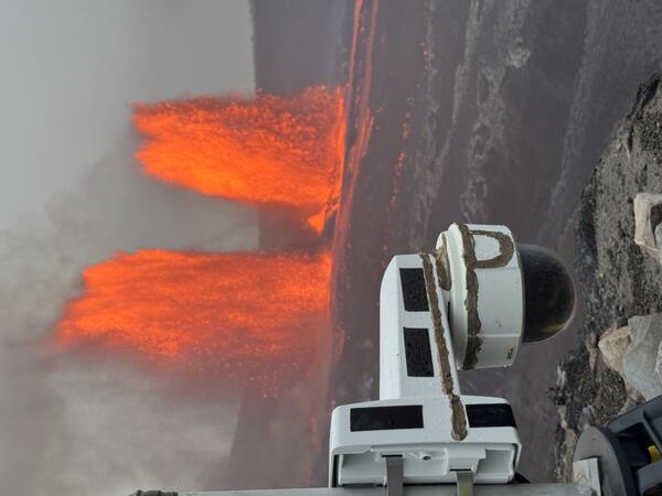
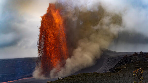
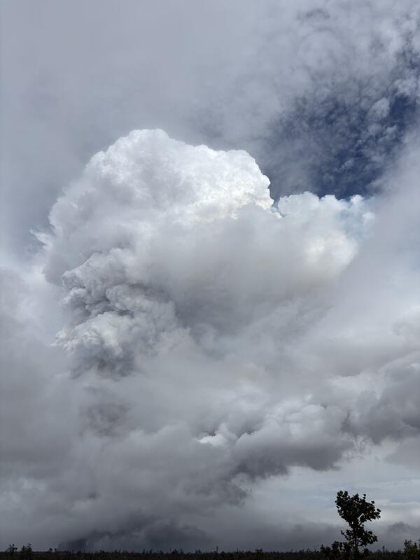
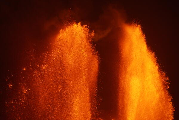
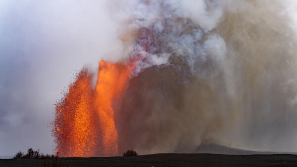
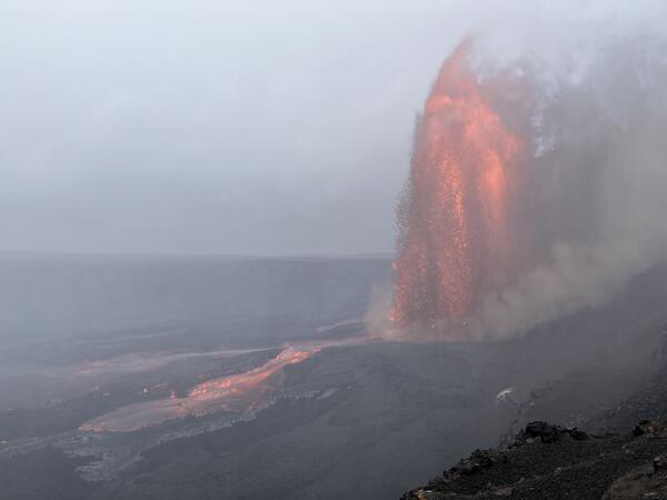
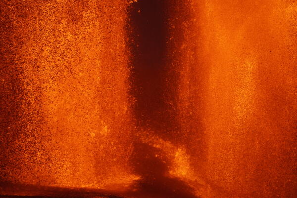
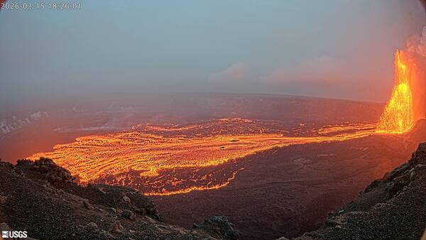
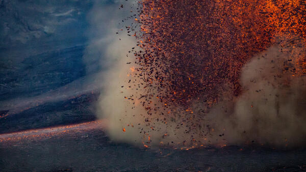
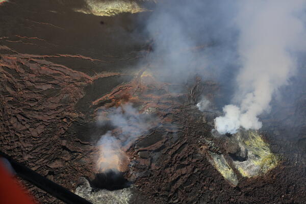
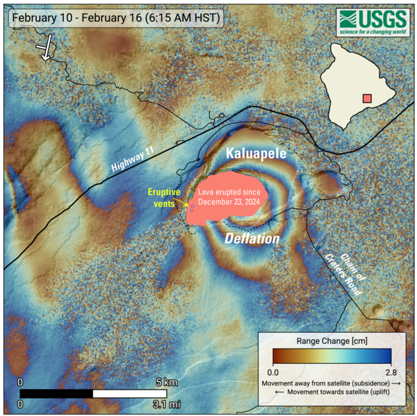
U.S. flag

An official website of the United States government

Images

Hawaiian Volcano Observatory images of eruptive activity, field work, and more.

Filter Total Items: 3749
Color photograph of a lava fountain erupting at night
June 20, 2025 — Lava fountaining during episode 26 at Kīlauea summit

The appearance of layers in the fountains represents discrete pulses at the base of the fountain, highlighting the dynamic nature of lava exiting the vent. The fountain supplied lava into channels that flowed north along the edge of the crater floor, into the eastern crater. USGS photo by M. Patrick.

The appearance of layers in the fountains represents discrete pulses at the base of the fountain, highlighting the dynamic nature of lava exiting the vent. The fountain supplied lava into channels that flowed north along the edge of the crater floor, into the eastern crater. USGS photo by M. Patrick.

Color photograph of lava fountain
Episode 26 lava fountain at the summit of Kīlauea

Episode 26 lava fountaining at the summit of Kīlauea. The episode was dominated by fountaining from the north vent, and reached over 350 m (1150 feet). USGS photo. 

Episode 26 lava fountaining at the summit of Kīlauea. The episode was dominated by fountaining from the north vent, and reached over 350 m (1150 feet). USGS photo. 

Color photograph of lava flows from volcanic vent
June 20, 2025 — Lava flowing from the north vent during episode 26 on Kīlauea

A view of the complex flow of lava exiting the north vent crater at Kīlauea summit during episode 26 of the ongoing eruption. USGS photo by M. Patrick.

Color photograph of a lava fountain at night
June 20, 2025 — Lava fountaining during episode 26 at Kīlauea summit

Episode 26 of lava fountaining during the ongoing Kīlauea summit eruption began just after midnight, on June 20, and reached heights of over 300 meters (1000 feet).

Color photograph of a scientist measuring a new volcanic deposit
June 20, 2025 — Measuring the growing tephra deposit on Kīlauea

A USGS geologist surveys the height of the new tephra cone formed by the recent lava fountaining episodes at the summit of Kīlauea. This tephra cone now towers over, and covers, Crater Rim Drive, which has been closed to the public since 2008.

A USGS geologist surveys the height of the new tephra cone formed by the recent lava fountaining episodes at the summit of Kīlauea. This tephra cone now towers over, and covers, Crater Rim Drive, which has been closed to the public since 2008.

Color photograph of the base of a lava fountain at night
June 20, 2025 — Lava fountaining during episode 26 at Kīlauea summit

A close-up view of the base of the north fountain during episode 26, as well as the start of the lava channels draining the vent craters. These channels often had standing waves, resembling a fast-moving river. USGS photo by M. Patrick.

A close-up view of the base of the north fountain during episode 26, as well as the start of the lava channels draining the vent craters. These channels often had standing waves, resembling a fast-moving river. USGS photo by M. Patrick.

Color photograph of scientist observing lava fountain
June 20, 2025 — Lava fountaining at Kīlauea during episode 26

A USGS Hawaiian Volcano Observatory geologist collects video and makes observations of lava fountain behavior on the western caldera rim during the morning on June 20. USGS photo by M. Patrick.

A USGS Hawaiian Volcano Observatory geologist collects video and makes observations of lava fountain behavior on the western caldera rim during the morning on June 20. USGS photo by M. Patrick.

Color photograph of fern growing on otherwise desolate ground surface
June 18, 2025 — Kīlauea eruptive pause before episode 26

Tephra deposits from the recent lava fountaining at Kīlauea summit have blanketed the western caldera rim, killing much of the vegetation in this area. Nevertheless, some plants are starting to sprout up again through the cinder.

Tephra deposits from the recent lava fountaining at Kīlauea summit have blanketed the western caldera rim, killing much of the vegetation in this area. Nevertheless, some plants are starting to sprout up again through the cinder.

Color photograph of car driving on tephra deposit
June 18, 2025 — Kīlauea eruption pause before episode 26

Thick tephra deposits downwind (southwest) of the active vents at Kīlauea summit have covered roadways used to access critical monitoring equipment, requiring 4wd to navigate to these instrument sites. USGS photo by M. Patrick.

Thick tephra deposits downwind (southwest) of the active vents at Kīlauea summit have covered roadways used to access critical monitoring equipment, requiring 4wd to navigate to these instrument sites. USGS photo by M. Patrick.

Color photographs of two scientists standing near volcanic depressions
USGS Hawaiian Volcano Observatory summer 2025 interns

USGS Hawaiian Volcano Observatory summer 2025 interns Kamalani Poepoe (left) and Ruth Gale (right). Kamalani is pictured earlier this year on the rim of Kaluapele, the summit caldera of Kīlauea volcano, in Hawaiʻi Volcanoes National Park during one of the fountaining phases of the summit eruption in Halemaʻumaʻu.

USGS Hawaiian Volcano Observatory summer 2025 interns Kamalani Poepoe (left) and Ruth Gale (right). Kamalani is pictured earlier this year on the rim of Kaluapele, the summit caldera of Kīlauea volcano, in Hawaiʻi Volcanoes National Park during one of the fountaining phases of the summit eruption in Halemaʻumaʻu.

Color photograph of spatter within a volcanic vent
June 18, 2025 — Kīlauea eruptive pause before episode 26

Cycles of gas pistoning were observed in the north vent, at Kīlauea summit, by USGS Hawaiian Volcano Observatory geologists looking down upon the vent from the caldera rim on June 18. The peak of each cycle produced loud jetting sounds and a brief glimpse of spatter, but the lava column was not visible and no lava flows were produced. USGS photo by M. Patrick.

Cycles of gas pistoning were observed in the north vent, at Kīlauea summit, by USGS Hawaiian Volcano Observatory geologists looking down upon the vent from the caldera rim on June 18. The peak of each cycle produced loud jetting sounds and a brief glimpse of spatter, but the lava column was not visible and no lava flows were produced. USGS photo by M. Patrick.

Color photograph of volcanic vent within crater
June 18, 2025 — Kīlauea eruptive pause before episode 26

Lava fountaining remained paused on Wednesday, June 18, nearly a week after episode 25 produced impressive lava fountains at Kīlauea summit. HVO geologists on the rim observed cycles of gas-pistoning in the north vent, associated with a small amount of visible spatter and loud jetting sounds. USGS photo by M. Patrick.

Lava fountaining remained paused on Wednesday, June 18, nearly a week after episode 25 produced impressive lava fountains at Kīlauea summit. HVO geologists on the rim observed cycles of gas-pistoning in the north vent, associated with a small amount of visible spatter and loud jetting sounds. USGS photo by M. Patrick.

Color photograph of hills covered with small volcanic rocks
June 16, 2025 — View of Kīlauea summit tephra deposit after episode 25

A view of the thick deposit of tephra from the high fountaining of episode 25—along with accumulation from previous episodes—of the ongoing Kīlauea summit eruption, which blankets the crater rim southwestern rim of Halema‘uma‘u.

A view of the thick deposit of tephra from the high fountaining of episode 25—along with accumulation from previous episodes—of the ongoing Kīlauea summit eruption, which blankets the crater rim southwestern rim of Halema‘uma‘u.

Color photograph of rock stuck in melted edge of plastic bucket
June 16, 2025 — Tephra collection bucket damaged during episode 25 of Kīlauea's ongoing eruptionJune

Photo of a partially melted bucket with an embedded tephra clast erupted during episode 25 of the ongoing eruption at Kīlauea. Buckets are used to collect tephra, and emptied between episodes, to ensure that samples from each episode are isolated to track geochemical changes and determine the amount of tephra that fell at each site.

Photo of a partially melted bucket with an embedded tephra clast erupted during episode 25 of the ongoing eruption at Kīlauea. Buckets are used to collect tephra, and emptied between episodes, to ensure that samples from each episode are isolated to track geochemical changes and determine the amount of tephra that fell at each site.

Color photograph of rock covered ground surface
June 16, 2025 — View of tephra deposit across Kīlauea's upper Southwest Rift Zone

The photo provides a view from near the top of the tephra deposit that accumulated during recent episodes of the ongoing eruption at Kīlauea volcano, looking west towards Kīlauea's upper Southwest Rift Zone. The brown material covering and filling in topographic lows on the landscape erupted since the eruption started on December 23, 2024.

The photo provides a view from near the top of the tephra deposit that accumulated during recent episodes of the ongoing eruption at Kīlauea volcano, looking west towards Kīlauea's upper Southwest Rift Zone. The brown material covering and filling in topographic lows on the landscape erupted since the eruption started on December 23, 2024.

Color map of eruption area
June 13, 2025—Kīlauea summit eruption reference map

This reference map depicts the Kīlauea summit eruption within Halema‘uma‘u crater that began on December 23, 2024. As of this posting on June 13, the eruption continues episodically.

This reference map depicts the Kīlauea summit eruption within Halema‘uma‘u crater that began on December 23, 2024. As of this posting on June 13, the eruption continues episodically.

Color photograph of tripod on lava flow with mountain in the background
2025 Annual Campaign GPS measurements in progress

A benchmark on the northwest side of Mauna Loa's summit being surveyed by GPS campaign instruments. The metal disk on the ground beneath the tripod is the benchmark, which is cemented to the lava flow surface so that the specific spot can be measured each year. Mauna Kea is visible in the background. USGS photo by A. Ellis.


A benchmark on the northwest side of Mauna Loa's summit being surveyed by GPS campaign instruments. The metal disk on the ground beneath the tripod is the benchmark, which is cemented to the lava flow surface so that the specific spot can be measured each year. Mauna Kea is visible in the background. USGS photo by A. Ellis.


Color photograph of volcano monitoring station with cabin in background
2025 Annual Campaign GPS measurements in progress

Campaign, also known as 'survey', GPS data augment the permanent, continuously recording GPS instruments in HVO's monitoring network. In this photo, a tripod mounted with a GPS antenna is temporarily installed over a benchmark the rim of Moku‘āweoweo, the caldera at the summit of Mauna Loa.

Campaign, also known as 'survey', GPS data augment the permanent, continuously recording GPS instruments in HVO's monitoring network. In this photo, a tripod mounted with a GPS antenna is temporarily installed over a benchmark the rim of Moku‘āweoweo, the caldera at the summit of Mauna Loa.

Color photograph of tripod on lava flow with helicopter in the background
2025 Annual Campaign GPS measurements in progress

USGS Hawaiian Volcano Observatory staff are conducting the annual Mauna Loa GPS campaign. During the survey, GPS instruments are deployed at established benchmarks so that their recorded positions can be compared with those from previous years to discern small changes in ground deformation associated with volcanic activity.

USGS Hawaiian Volcano Observatory staff are conducting the annual Mauna Loa GPS campaign. During the survey, GPS instruments are deployed at established benchmarks so that their recorded positions can be compared with those from previous years to discern small changes in ground deformation associated with volcanic activity.

Two color photographs comparing views months apart
Aerial images comparing the tephra deposit southwest of Halemaʻumaʻu

Aerial images comparing the tephra deposit southwest of Halemaʻumaʻu crater (left) from the ongoing eruption at Kīlauea summit. The top image, taken on December 27, 2024, during episode 3, shows a thin layer of tephra (brown) has already accumulated on the left side of the image.

Aerial images comparing the tephra deposit southwest of Halemaʻumaʻu crater (left) from the ongoing eruption at Kīlauea summit. The top image, taken on December 27, 2024, during episode 3, shows a thin layer of tephra (brown) has already accumulated on the left side of the image.

Color photograph of tripod on vegetated lava flow
2025 Annual Campaign GPS measurements in progress

Another GPS survey benchmark being occupied on Mauna Loa's lower southwest flank. USGS photo by A. Ellis.

Was this page helpful?