
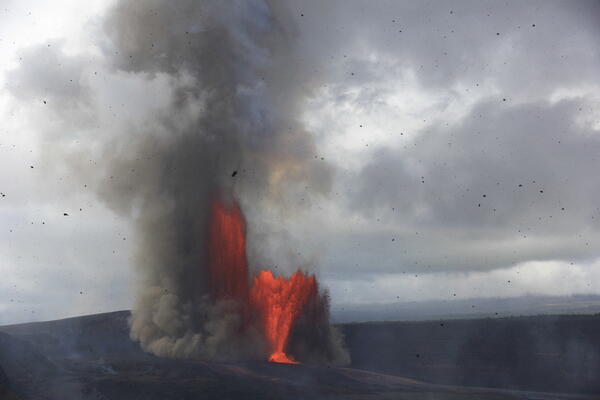
USGS Hawaiian Volcano Observatory scientists observed and documented episode 41 of the episodic Kīlauea summit eruption in Halema‘uma‘u. This photograph, taken from the Keanakāko‘i Overlook in Hawaiʻi Volcanoes National Park, shows lava fountains from both the north and south vents, with tephra falling in the foreground. USGS photo by H. Winslow.
Images
Hawaiian Volcano Observatory images of eruptive activity, field work, and more.
Filter Total Items: 4072
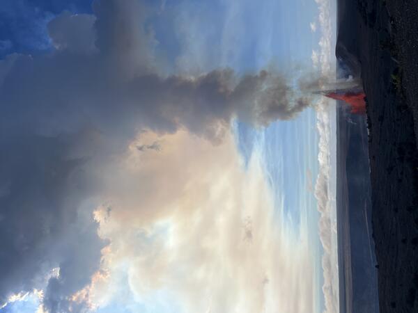
January 24, 2026 — Kīlauea episode 41
USGS Hawaiian Volcano Observatory scientists observed and documented episode 41 of the episodic Kīlauea summit eruption in Halema‘uma‘u. This photograph, taken from the Keanakāko‘i Overlook in Hawaiʻi Volcanoes National Park, shows lava fountains from both the north and south vents, with tephra falling in the foreground. USGS photo by H. Winslow.
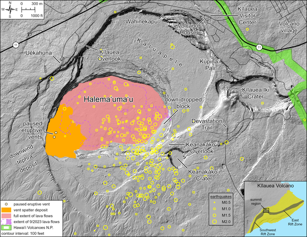
January 22, 2026—Summary map of recent earthquakes at the summit of Kīlauea volcano
January 22, 2026—Summary map of recent earthquakes at the summit of Kīlauea volcanoThis map depicts the locations of approximately 300 earthquakes that have occurred between January 12 and 22, 2026, in the summit region of Kīlauea volcano. Most earthquakes have been smaller than magnitude-2, with locations broadly distributed beneath Halemaʻumaʻu and the south caldera region of Kīlauea summit.
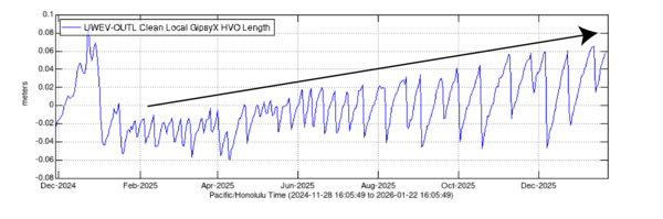
Kīlauea cross-caldera distance determined by GPS stations
Kīlauea cross-caldera distance determined by GPS stationsThis plot shows the line length between two GPS stations in Kīlauea summit region (UWEV and OUTL) since the episodic summit eruption began on December 23, 2024. These stations are located on opposite sides of the caldera and the distance between them can be used as a proxy for pressurization within the shallow Halemaʻumaʻu magma chamber.
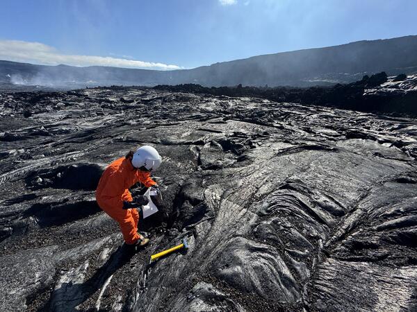
January 16, 2026 — Collecting a sample of a recent Kīlauea lava flow in Halema'uma'u crater
January 16, 2026 — Collecting a sample of a recent Kīlauea lava flow in Halema'uma'u craterA USGS Hawaiian Volcano Observatory geologist collects a sample of the short lava flows that were erupted from the south vent just before episode 40 lava fountaining began on January 12, 2026. All sampling in Halema‘uma‘u crater is done with permission from Hawai‘i Volcanoes National Park.
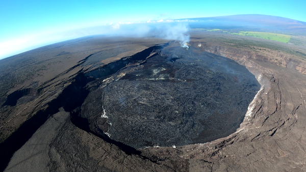
January 16, 2026 — Halemaʻumaʻu crater at the summit of Kīlauea
January 16, 2026 — Halemaʻumaʻu crater at the summit of KīlaueaOn Friday, January 16, USGS Hawaiian Volcano Observatory geologists conducted an overflight of Kīlauea summit to map the effects of episode 40 and collect samples of the lava. This wide-angle photo shows the episode 40 flows reaching the crater wall in the foreground, with the vents in the distance.
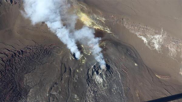
January 16, 2026 — Aerial view of the north and south vents in Halemaʻumaʻu at the summit of Kīlauea
January 16, 2026 — Aerial view of the north and south vents in Halemaʻumaʻu at the summit of KīlaueaThis photograph shows the current vent area at the summit of Kīlauea, with passive outgassing plumes originating from the south (left) and north (right) vents. The plumes are carried to the southwest by the tradewinds.
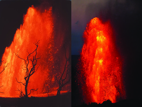
Maunaulu (1969) and Halema'uma'u (2025) lava fountains
Maunaulu (1969) and Halema'uma'u (2025) lava fountainsLeft: Lava fountains on September 6, 1969, during the Maunaulu eruption. Right: Lava fountains on July 9, 2025, during the Halemaʻumaʻu eruption (episode 28). USGS photos.
Maunaulu (1969) and Halema'uma'u (2025) lava fountains
Maunaulu (1969) and Halema'uma'u (2025) lava fountainsLeft: Lava fountains on September 6, 1969, during the Maunaulu eruption. Right: Lava fountains on July 9, 2025, during the Halemaʻumaʻu eruption (episode 28). USGS photos.
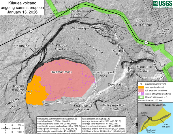
January 13, 2026—Kīlauea summit eruption reference map
January 13, 2026—Kīlauea summit eruption reference mapThis reference map depicts the Kīlauea summit eruption within Halema‘uma‘u crater that began on December 23, 2024. The data for this map were collected during a Hawaiian Volcano Observatory helicopter overflight on January 2, 2026; as such, the provided statistics are reflective of the first thirty-nine episodes of the eruption through December 24, 2025.
January 12, 2026 — Kīlauea episode 40 from Uēkahuna
January 12, 2026 — Kīlauea episode 40 from UēkahunaOn January 12, 2026, Kīlauea had its 40th fountaining episode of the ongoing eruption within Halema‘uma‘u. This view was taken at 10:50 a.m. H.S.T. from the publicly accessible viewing area at Uēkahuna within Hawaiʻi Volcanoes National Park, showing north vent fountaining. USGS photo by N. Deligne.
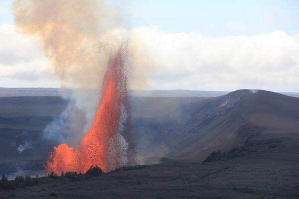
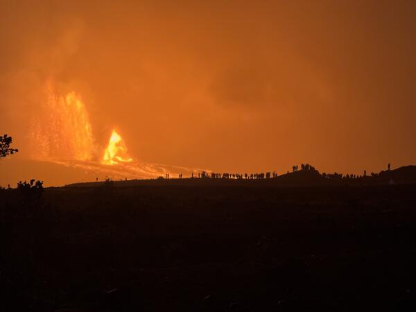
January 12, 2026 — Kīlauea episode 40 fountains from Uēkahuna overlook
January 12, 2026 — Kīlauea episode 40 fountains from Uēkahuna overlookUSGS Hawaiian Volcano Observatory geologists observe episode 40 fountains from the Uēkahuna overlook within Hawai‘i Volcanoes National Park. This episode had multiple days of precursory overflows from both the north and south vents, leading to fountains primarily from the north vent starting on January 12 and reaching up to 800 feet (250 meters).
January 12, 2026 — Kīlauea episode 40 from Kūpinaʻi Pali
January 12, 2026 — Kīlauea episode 40 from Kūpinaʻi PaliOn January 12, 2026, Kīlauea had its 40th fountaining episode of the ongoing eruption within Halema‘uma‘u. This photo was taken at 4:37 p.m. HST from the publicly accessible viewing area at Kūpinaʻi Pali (Waldron's Ledge) within Hawaiʻi Volcanoes National Park, showing north vent fountaining. The episode ended about an hour and a half after this photo was taken.
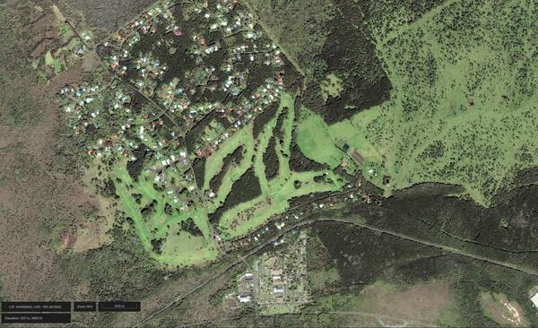
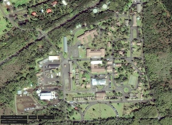
January 7, 2026 — Satellite image of Kilauea Military Camp and Volcano Golf Course
January 7, 2026 — Satellite image of Kilauea Military Camp and Volcano Golf CourseSatellite image of Kilauea Military Camp near Kīlauea summit in Hawaiʻi Volcanoes National Park and neighboring Volcano Golf Course subdivision taken on January 7, 2026, and showing green grass and vegetation surrounding infrastructure. Image credit: WorldView ©2026 Maxar, USG Plus.
January 7, 2026 — Satellite image of Kilauea Military Camp
January 7, 2026 — Satellite image of Kilauea Military CampSatellite image of Kilauea Military Camp near Kīlauea summit in Hawaiʻi Volcanoes National Park and neighboring Volcano Golf Course subdivision taken on January 7, 2026, and showing green grass and vegetation surrounding infrastructure. Image credit: WorldView ©2026 Maxar, USG Plus.

Electronic Tilt at Kīlauea Summit December 24, 2025 - January 6, 2026
Electronic Tilt at Kīlauea Summit December 24, 2025 - January 6, 2026Data plot showing electronic tilt at station UWD, located near Kīlauea summit, from December 24, 2025 - January 6, 2026. USGS plot.
Electronic Tilt at Kīlauea Summit December 24, 2025 - January 6, 2026
Electronic Tilt at Kīlauea Summit December 24, 2025 - January 6, 2026Data plot showing electronic tilt at station UWD, located near Kīlauea summit, from December 24, 2025 - January 6, 2026. USGS plot.
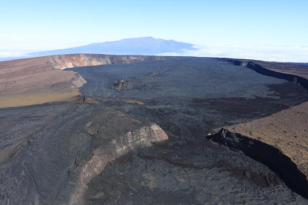
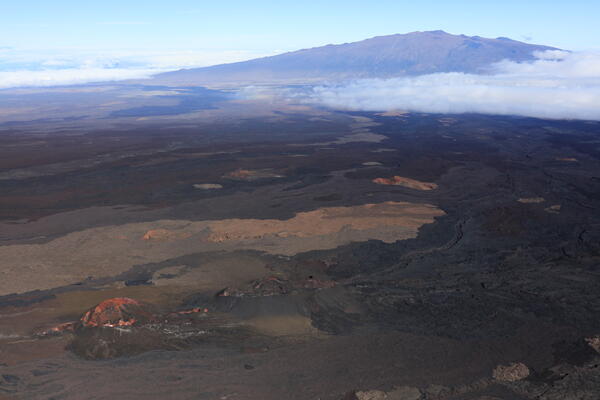
December 23, 2025 — Mauna Loa summit and Mauna Kea
December 23, 2025 — Mauna Loa summit and Mauna KeaOn Tuesday, December 23, USGS Hawaiian Volcano Observatory scientists completed a helicopter overflight of Mauna Loa's summit and upper rift zones. This photo—captured looking north-northeast—shows South Pit (foreground) and Moku‘āweoweo caldera (middle distance) with Mauna Kea looming behind. USGS photo by M. Zoeller.
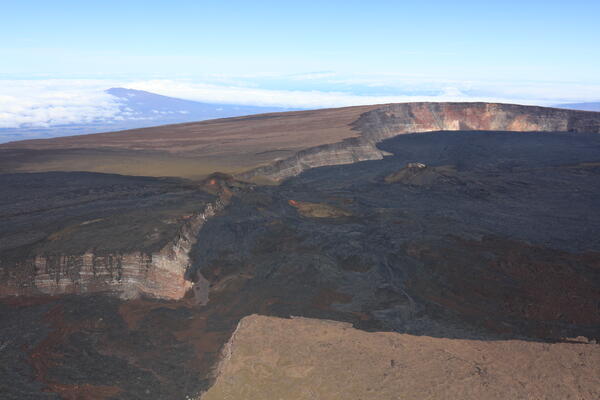
December 23, 2025 — Moku‘āweoweo caldera and Hualālai
December 23, 2025 — Moku‘āweoweo caldera and HualālaiDuring the Mauna Loa summit overflight on Tuesday, December 23, a USGS Hawaiian Volcano Observatory geologist captured this northwest-looking view of southern Moku‘āweoweo caldera with Hualālai behind to the left and Haleakalā on Maui barely visible above distant clouds.
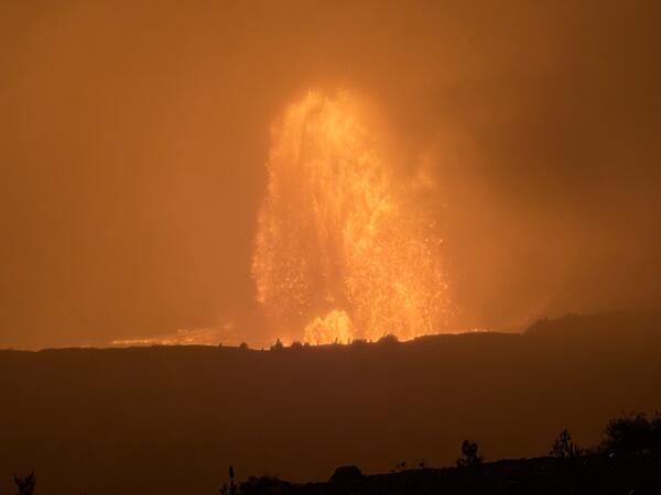
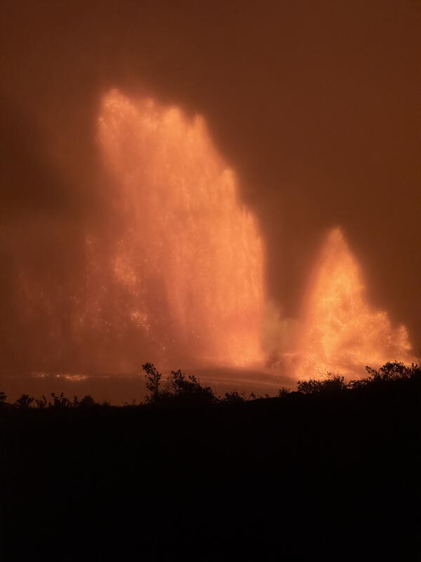
December 23, 2025 — Kīlauea eruption episode 39
Episode 39 of the ongoing Halemaʻumaʻu eruption at the summit of Kīlauea volcano began on December 23, 2025, at approximately 8:20 p.m. and ended abruptly at 2:13 a.m. HST on December 24, 2025, after about 6 hours of continuous fountaining. USGS photograph by Lis Gallant.
Episode 39 of the ongoing Halemaʻumaʻu eruption at the summit of Kīlauea volcano began on December 23, 2025, at approximately 8:20 p.m. and ended abruptly at 2:13 a.m. HST on December 24, 2025, after about 6 hours of continuous fountaining. USGS photograph by Lis Gallant.
December 23, 2025 — Mauna Loa summit and Mauna Kea
December 23, 2025 — Mauna Loa summit and Mauna KeaAt the end of their Mauna Loa summit overflight on December 23, USGS Hawaiian Volcano Observatory geologists passed the 2022 Northeast Rift Zone eruption site. In this photo, an older vent known as Steaming Cone is visible in the lower-left of the frame (red and white colors), with the 2022 fissure 3 cone just to the right of it (black and brown colors).
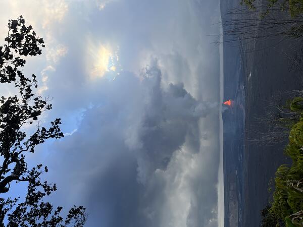
December 23, 2025 — Kīlauea episode 39
Kīlauea began its 39th lava fountaining episode the night of December 23, one year to the day from when this eruption began. This view was taken from the publicly accessible viewing area on Crater Rim Drive near Keanakākoi Overlook within Hawaiʻi Volcanoes National Park.
Kīlauea began its 39th lava fountaining episode the night of December 23, one year to the day from when this eruption began. This view was taken from the publicly accessible viewing area on Crater Rim Drive near Keanakākoi Overlook within Hawaiʻi Volcanoes National Park.
December 23, 2025 — Kīlauea episode 39 through the mist
December 23, 2025 — Kīlauea episode 39 through the mistThe lava fountains that erupted during episode 39 at the summit of Kīlauea were visible through the rain and mist around 10 p.m. HST on December 23. This episode was actively erupting for just about 6 hours from December 23-24, 2025. USGS photo.
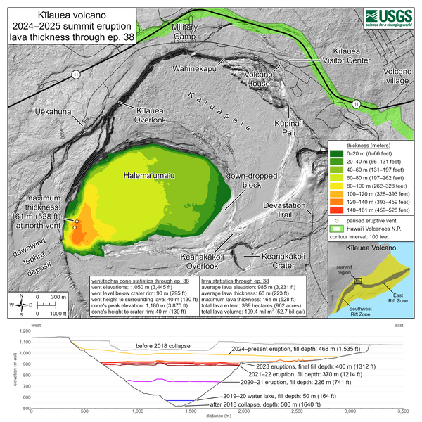
December 22, 2025—Kīlauea summit eruption lava thickness through episode 38
December 22, 2025—Kīlauea summit eruption lava thickness through episode 38This map shows thickness values for lava flows within Halema‘uma‘u crater from the Kīlauea summit eruption that began on December 23, 2024. These values were calculated by topographic differencing between a digital elevation model collected on December 9, 2025—after eruptive episode 38—and one from before the eruption began.