
Heavy rainfall the evening of March 10-11 eroded pathways in the tephra deposit from Kīlauea episode 43 lava fountaining. This photo was taken near the Volcano Golf Course and shows the tephra fallout deposit and underlying road. USGS photo.
Images
Hawaiian Volcano Observatory images of eruptive activity, field work, and more.
Filter Total Items: 4072
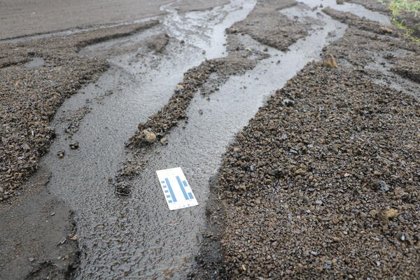
March 11, 2026 — Episode 43 tephra and rainfall
Heavy rainfall the evening of March 10-11 eroded pathways in the tephra deposit from Kīlauea episode 43 lava fountaining. This photo was taken near the Volcano Golf Course and shows the tephra fallout deposit and underlying road. USGS photo.
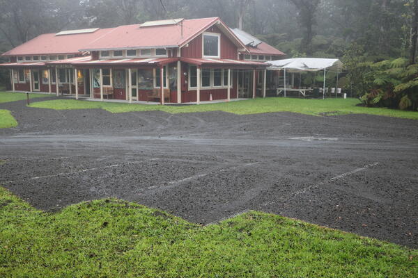
March 11, 2026 — Episode 43 tephra in Volcano Village
March 11, 2026 — Episode 43 tephra in Volcano VillageIn Volcano Village, located northeast of the eruptive vents at the summit of Kīlauea, fallout from episode 43 was less extensive than the areas to the west. This photograph shows a parking area that nearly continuously covered with tephra particles ranging up to a couple inches in diameter. USGS photo.
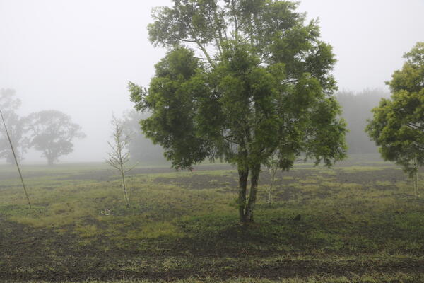
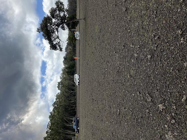
March 11, 2026 — Episode 43 fallout deposits at Volcano Golf Course
March 11, 2026 — Episode 43 fallout deposits at Volcano Golf CourseThe Volcano Golf Course, located north-northeast of the eruptive vents at the summit of Kīlauea received fallout from episode 43 lava fountains that nearly continuously covered the ground with tephra particles up to several inches in diameter. USGS photo.
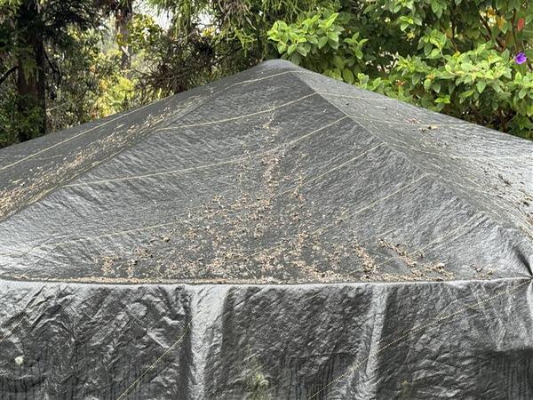
March 11, 2026 — Episode 43 fallout on a water tank cover
March 11, 2026 — Episode 43 fallout on a water tank coverTephra fallout from Kīlauea episode 43 lava fountaining accumulated on a water tank cover in Volcano Village, photographed on March 11, 2026. USGS photo.
March 11, 2026 — Episode 43 fallout on a water tank cover
March 11, 2026 — Episode 43 fallout on a water tank coverTephra fallout from Kīlauea episode 43 lava fountaining accumulated on a water tank cover in Volcano Village, photographed on March 11, 2026. USGS photo.
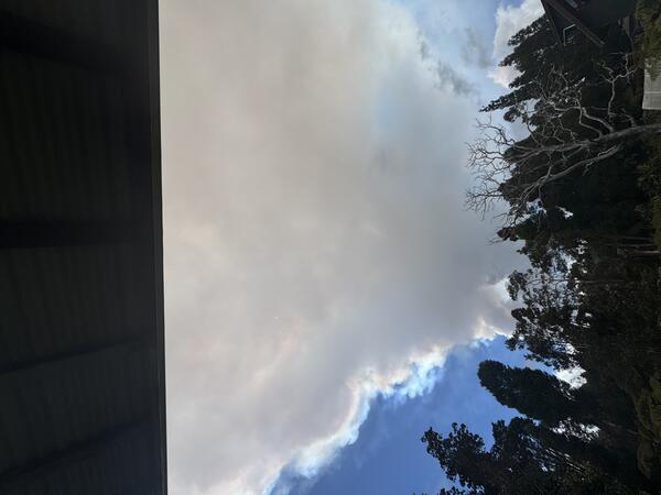
March 10, 2026 — Kīlauea episode 43 ashfall in Hilo
March 10, 2026 — Kīlauea episode 43 ashfall in HiloAsh fallout from Kīlauea summit lava fountaining episode 43 in Hilo just before 3 p.m. HST on March 10, 2026. USGS photo.
March 10, 2026 — Kīlauea episode 43 ashfall in Hilo
March 10, 2026 — Kīlauea episode 43 ashfall in HiloAsh fallout from Kīlauea summit lava fountaining episode 43 in Hilo just before 3 p.m. HST on March 10, 2026. USGS photo.
March 10, 2026 — Episode 43 tephra covers Kīlauea Military Camp lawn
March 10, 2026 — Episode 43 tephra covers Kīlauea Military Camp lawnNearly 5 hours into episode 43 of the ongoing eruption at Kīlauea, the lawn at Kīlauea Military Camp was covered with about an inch of tephra (2 to 3 cm). The underlying grass was barely visible. The deposit included reticulite bombs (large foamy tephra clasts) mixed in with smaller denser lapilli tephra. USGS photo by N. Deligne.
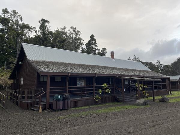
March 10, 2026 — Tephra on a building in Hawai‘i Volcanoes National Park
March 10, 2026 — Tephra on a building in Hawai‘i Volcanoes National ParkThis building within Hawai‘i Volcanoes National park is nearly 3 miles (4.7 km) east-northeast of north and south vents of the ongoing eruption of Kīlauea volcano. Tephra from episode 41 and 43 lava fountains of the ongoing Kīlauea eruption was deposited on this building. The upper portion of the roof is steeper and so falling tephra slide down it.
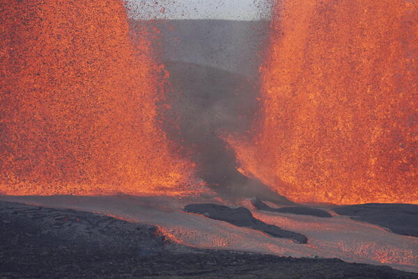
March 10, 2026 — Kīlauea episode 43 lava fountains bases
March 10, 2026 — Kīlauea episode 43 lava fountains basesThis photo shows the gap between the south (left) and north (right) lava fountains on March 10, 2026, as well as the lava channels that transport lava from the vent to the eastern crater floor. These fountains were active during episode 43 at the summit of Kīlauea. USGS photo by M. Patrick.

Episode 43 of the ongoing Halema‘uma‘u eruption at Kīlauea summit
Episode 43 of the ongoing Halema‘uma‘u eruption at Kīlauea summitEpisode 43 of the ongoing Halema‘uma‘u eruption at Kīlauea summit ended at 6:21 p.m. HST on March 10. About 15 minutes after the end of the episode, USGS scientists serviced a webcam near Keanakāko‘i on the southeast caldera rim. Active lava flows continued to slowly advance along the crater floor, and stand out here in the low lighting.
March 10, 2026 — Episode 43 at the summit of Kīlauea
March 10, 2026 — Episode 43 at the summit of KīlaueaEpisode 43 of the Kīlauea summit eruption ended after about 9 hours with both the north and south vents active. The highest peak or instantaneous effusion rate of 1000 cubic yards (800 cubic meters) per second occurred around 10:30 a.m. HST on March 10. Episode 43 ended with an average effusion rate of 400 cubic yards per second (300 cubic meters per second).
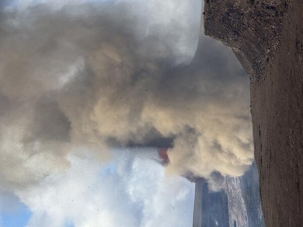
March 10, 2026 — Kīlauea episode 43 eruption plume
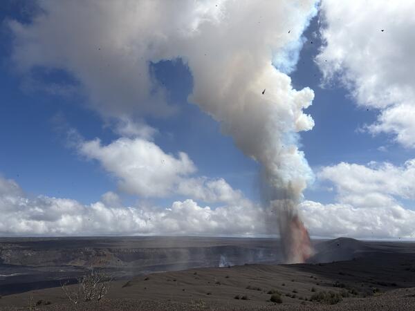
March 10, 2026 — Kīlauea episode 43 eruption plumeThe dual fountains that erupted during Kīlauea summit eruption episode 43 on March 10, 2026, produced significant heat and ash, creating an eruption plume. The plume reached 10,000 feet (3050 meters) above sea level at 10:10 a.m. HST, over 20,000 feet (6100 meters) by 11:30 a.m. HST, and over 25,000 feet (7600 meters) above sea level by 10:50 a.m. HST.
March 10, 2026 — Kīlauea episode 43 eruption plume
March 10, 2026 — Kīlauea episode 43 eruption plumeThe dual fountains that erupted during Kīlauea summit eruption episode 43 on March 10, 2026, produced significant heat and ash, creating an eruption plume. The plume reached 10,000 feet (3050 meters) above sea level at 10:10 a.m. HST, over 20,000 feet (6100 meters) by 11:30 a.m. HST, and over 25,000 feet (7600 meters) above sea level by 10:50 a.m. HST.
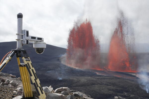
March 10, 2026 — Kīlauea episode 43 lava fountains and V3cam
March 10, 2026 — Kīlauea episode 43 lava fountains and V3camThe V3cam is situated on the south rim of the caldera, at the summit of Kīlauea, and provides good views of the two separate fountains that have been active during the ongoing episodic eruption in Halemaʻumaʻu. This photo shows episode 43 lava fountaining activity with the south (left) and north (right) fountains active. USGS photo by M. Patrick.
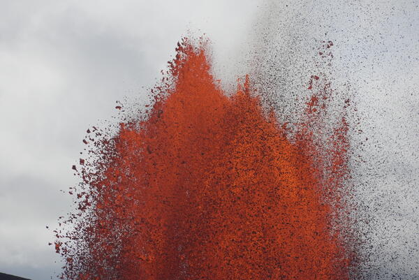
March 10, 2026 — Kīlauea episode 43 lava fountain top
March 10, 2026 — Kīlauea episode 43 lava fountain topThe top portion of the south lava fountain during episode 43 lava fountaining activity at the summit of Kīlauea, showing the range of sizes of clasts the separate out from the fountain. USGS photo by M. Patrick.
March 10, 2026 — Episode 43 lava fountain
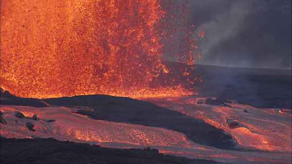
Activity during the episode 43 lava fountains at the summit of Kīlauea, from the south rim of the crater. This area provided clear views of the north and south fountains, and the lava channels that transported lava from the vent into the eastern portion of the crater floor. USGS photo by M. Patrick.
Activity during the episode 43 lava fountains at the summit of Kīlauea, from the south rim of the crater. This area provided clear views of the north and south fountains, and the lava channels that transported lava from the vent into the eastern portion of the crater floor. USGS photo by M. Patrick.
March 10, 2026 — Kīlauea episode 43 dual lava fountains
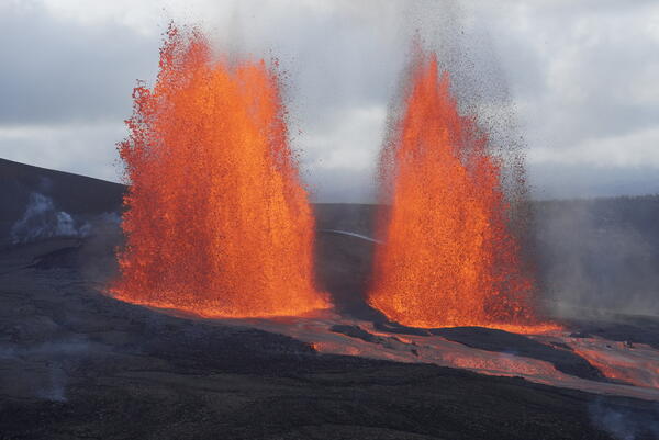
March 10, 2026 — Kīlauea episode 43 dual lava fountainsThis photo was taken from the south rim of Halemaʻumaʻu crater and shows the south and north fountains active during episode 43 at the summit of Kīlauea. USGS photo by M. Patrick.
March 10, 2026 — Kīlauea episode 43 dual lava fountains
March 10, 2026 — Kīlauea episode 43 dual lava fountainsThis photo was taken from the south rim of Halemaʻumaʻu crater and shows the south and north fountains active during episode 43 at the summit of Kīlauea. USGS photo by M. Patrick.
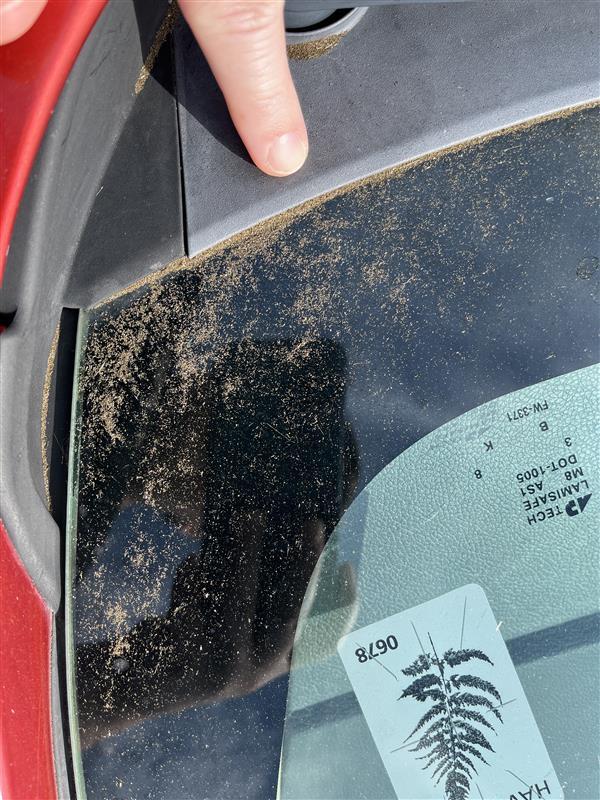
March 10, 2026 — Kīlauea episode 43 tephra on a car within Hawai‘i Volcanoes National Park
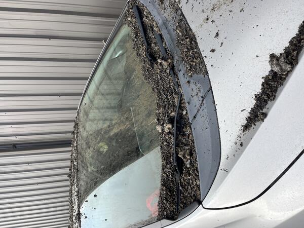
March 10, 2026 — Kīlauea episode 43 tephra on a car within Hawai‘i Volcanoes National ParkThis car was parked within Hawai‘i Volcanoes National Park, nearly 3 miles (4.7 km) east-northeast of north and south vents of the ongoing eruption of Kīlauea volcano. The photo shows about 7 hours of tephra fall accumulation from episode 43.
March 10, 2026 — Kīlauea episode 43 tephra on a car within Hawai‘i Volcanoes National Park
March 10, 2026 — Kīlauea episode 43 tephra on a car within Hawai‘i Volcanoes National ParkThis car was parked within Hawai‘i Volcanoes National Park, nearly 3 miles (4.7 km) east-northeast of north and south vents of the ongoing eruption of Kīlauea volcano. The photo shows about 7 hours of tephra fall accumulation from episode 43.

March 10, 2026 — Episode 43 tephra on a roof in Mauna Loa Estates
March 10, 2026 — Episode 43 tephra on a roof in Mauna Loa EstatesTephra fallout from episode 43 lava fountaining at the summit of Kīlauea accumulated on a roof in Mauna Loa Estates, east of the eruptive vents. Fallout in this area was less severe than what occurred during episode 41, and included particles up to 3 inches in diameter but coverage was not continuous. USGS photo.

March 10, 2026 — Episode 43 fallout on a floor in Hilo
March 10, 2026 — Episode 43 fallout on a floor in HiloVolcanic ash and Pele's hair accumulated on a floor of a home located in Hilo after episode 43 lava fountaining at the summit of Kīlauea on March 10, 2026. The window was left open nearby and had a screen, but these small particles were able to waft inside. USGS photo.

Episode 43 of the Kīlauea summit eruption
A USGS scientist performs maintenance on an eruption monitoring camera during episode 43 of the ongoing Kīlauea summit eruption. Work within this area, which is closed to the public, is done with permission from Hawai‘i Volcanoes National Park. USGS photo taken by L. DeSmither on March 10, 2026.
A USGS scientist performs maintenance on an eruption monitoring camera during episode 43 of the ongoing Kīlauea summit eruption. Work within this area, which is closed to the public, is done with permission from Hawai‘i Volcanoes National Park. USGS photo taken by L. DeSmither on March 10, 2026.

March 10, 2026 — Episode 43 tephra deposits at Kilauea Military Camp
March 10, 2026 — Episode 43 tephra deposits at Kilauea Military CampThis photograph shows the grassy area around the flagpole at the Kilauea Military Camp in Hawaiʻi Volcanoes National Park. Tephra about 4-5 inches in diameter started falling at this location at about 10:20 a.m. HST, and in total the area received about 2 inches of accumulation that completely covered the ground surface. USGS photo.
March 10, 2026 — Episode 43 at the summit of Kīlauea
March 10, 2026 — Episode 43 at the summit of KīlaueaThe onset of episode 43 fountaining of the ongoing Halemaʻumaʻu eruption at the summit of Kīlauea occurred at 9:17 a.m. HST on March 10, 2026, about an hour after the start of precursory eruptions at 8:20 a.m. HST. The start of episode 43 was marked by a sharp increase in tremor and deflationary tilt recorded at the Uēkahuna tiltmeter (UWD).