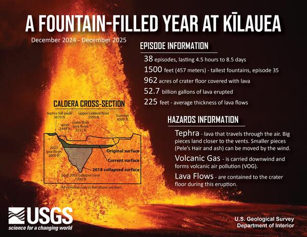
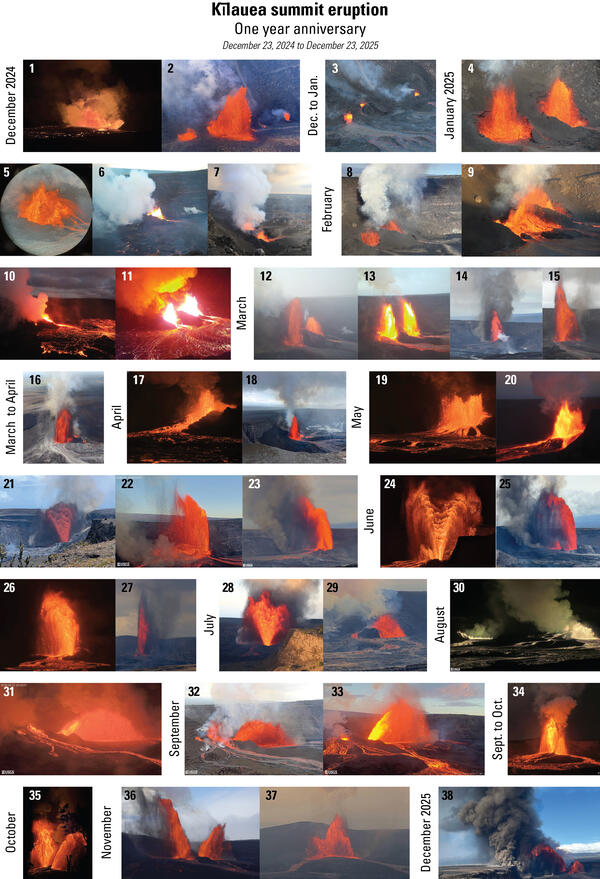
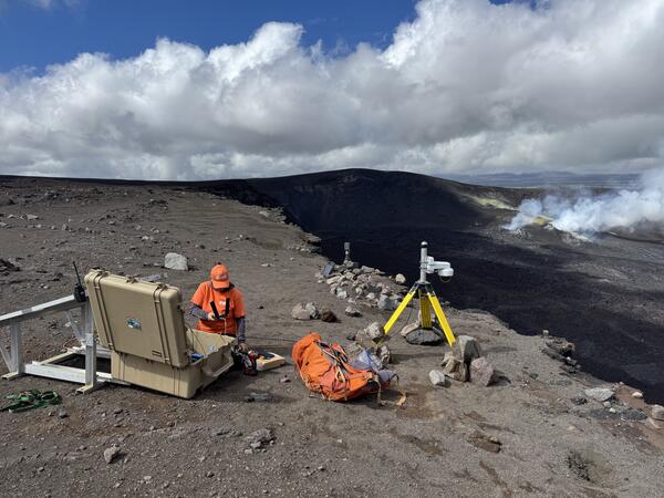
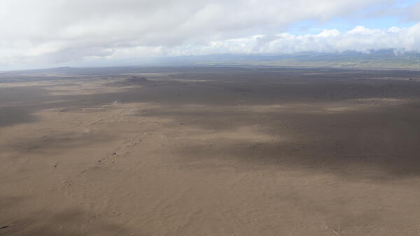
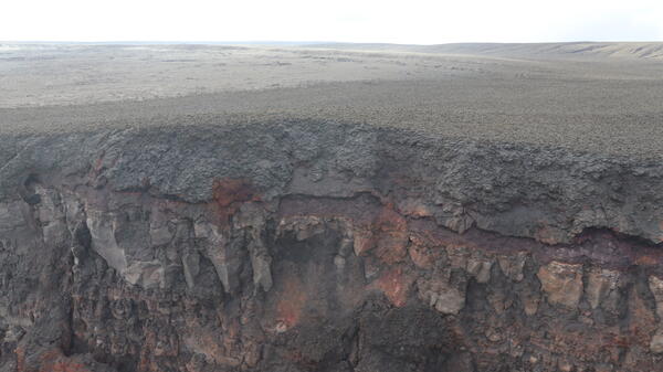
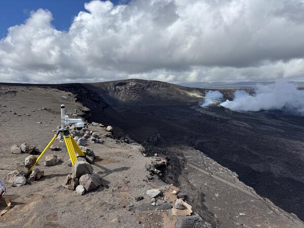
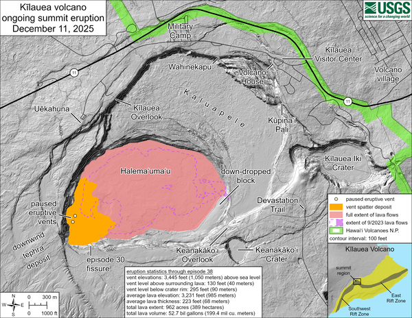
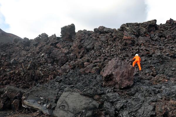
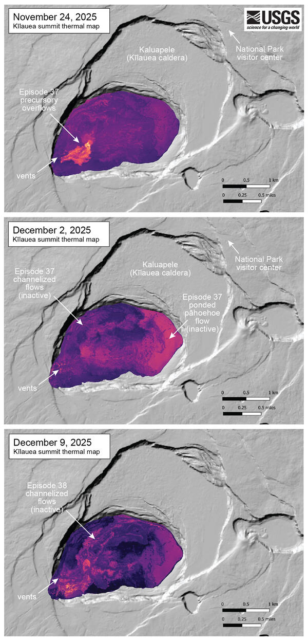
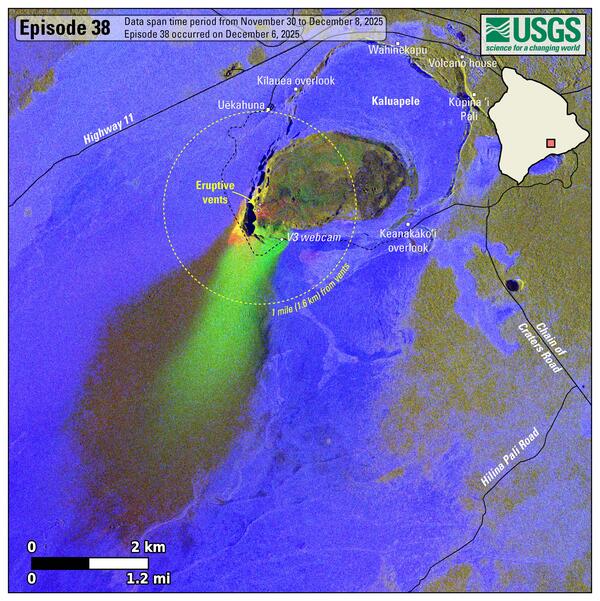
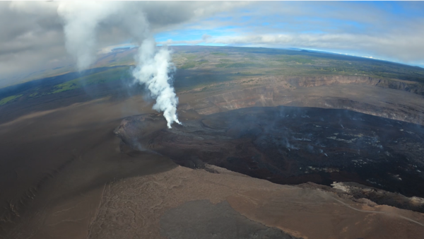
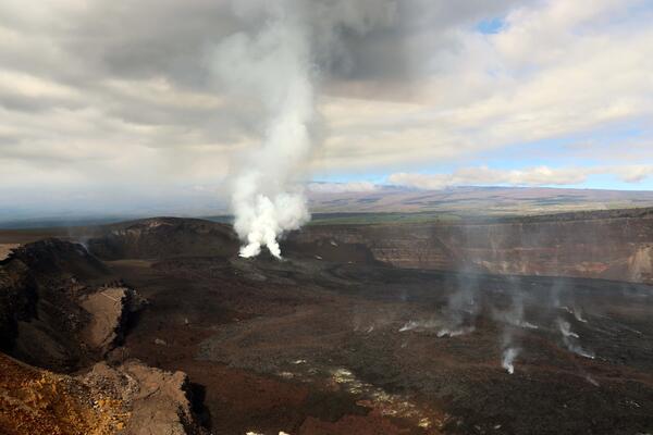
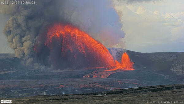
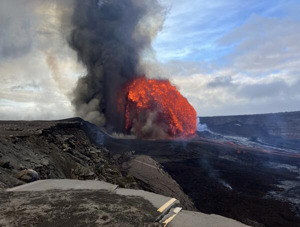
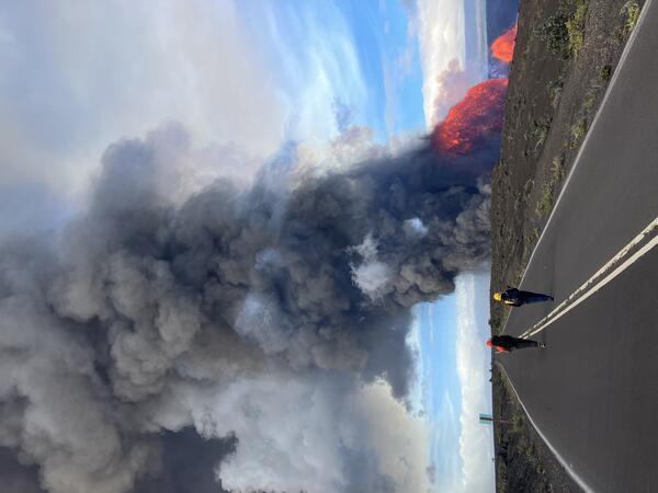
U.S. flag

An official website of the United States government

Images

Hawaiian Volcano Observatory images of eruptive activity, field work, and more.

Filter Total Items: 3761
Color photograph of volcanic plume rising above clouds
MKcam image of the Kīlauea eruption plume on May 25, 2025

The Kīlauea plume from episode 23 reached heights of more than 20,000 feet (6,100 meters) likely over 25,000 feet (7,600 meters)above Kīlauea’s summit, which is at an elevation of about 4,000 feet (1,200 meters) above sea level.

The Kīlauea plume from episode 23 reached heights of more than 20,000 feet (6,100 meters) likely over 25,000 feet (7,600 meters)above Kīlauea’s summit, which is at an elevation of about 4,000 feet (1,200 meters) above sea level.

Color photograph of lava fountain
May 25, 2025 — Kīlauea Episode 23

Episode 23 at the summit of Kīlauea included lava fountaining from both the south and north vents. The tall narrow finger of lava shown here, as well as the lower fountaining to the right, are both sourced from the south vent, while the wider fountain originates from the north vent. USGS photo by M. Patrick.

Episode 23 at the summit of Kīlauea included lava fountaining from both the south and north vents. The tall narrow finger of lava shown here, as well as the lower fountaining to the right, are both sourced from the south vent, while the wider fountain originates from the north vent. USGS photo by M. Patrick.

Color photograph of lava fountain within caldera framed by a tree
May 25, 2025 — Kīlauea Erupts in Kaluapele During Episode 23

Shortly after the start of episode 23 at 4:15 p.m. HST on May 25, the lava fountain and assocaited gas and tephra plume towered over the summit caldera of Kīlauea. USGS photo by M. Patrick.


Shortly after the start of episode 23 at 4:15 p.m. HST on May 25, the lava fountain and assocaited gas and tephra plume towered over the summit caldera of Kīlauea. USGS photo by M. Patrick.


Color photograph of scientist measuring volcanic plume from crater rim
May 22, 2025 — FTIR at Kīlauea summit

A USGS Hawaiian Volcano Observatory geologist uses an FTIR (Fourier transform infrared spectrometer) to measure the chemical composition of volcanic gas during cycles of spattering and seismic tremor at the active vent at Kīlauea summit on May 22, 2025. USGS photo by M. Patrick.

A USGS Hawaiian Volcano Observatory geologist uses an FTIR (Fourier transform infrared spectrometer) to measure the chemical composition of volcanic gas during cycles of spattering and seismic tremor at the active vent at Kīlauea summit on May 22, 2025. USGS photo by M. Patrick.

Color photograph of scientist adjusting camera near crater edge
May 22, 2025 — Adjusting V3cam at the summit of Kīlauea

On May 22, 2025, USGS Hawaiian Volcano Observatory (HVO) staff stabilized the new V3cam livestream camera. The camera was installed just last week and views since then were shaky due to the strong winds which are common in the caldera. The camera was moved from a tall mast to a more stable tripod setup.

On May 22, 2025, USGS Hawaiian Volcano Observatory (HVO) staff stabilized the new V3cam livestream camera. The camera was installed just last week and views since then were shaky due to the strong winds which are common in the caldera. The camera was moved from a tall mast to a more stable tripod setup.

Color plot showing seismic activity
Kīlauea spectrogram before episode 20

This spectrogram shows four hours of USGS Hawaiian Volcano Observatory data streams across six seismic stations at Kīlauea’s summit on May 6, 2025. Each panel is 10 minutes of data. Over the four-hour period, an earthquake, pulsing, and eruptive tremor are visible. 

This spectrogram shows four hours of USGS Hawaiian Volcano Observatory data streams across six seismic stations at Kīlauea’s summit on May 6, 2025. Each panel is 10 minutes of data. Over the four-hour period, an earthquake, pulsing, and eruptive tremor are visible. 

Color photograph of volcano monitoring webcamera station on the rim of a crater
May 22, 2025 — Kīlauea summit V3cam

A view of the V3cam site located on the south rim of Halemaʻumaʻu crater and Kaluapele. The camera, which was installed with permission from Hawaiʻi Volcanoes National Park, is one of three that provide livestream views of the ongoing episodic eruption at the summit of Kīlauea. USGS photo by M. Warren. 

A view of the V3cam site located on the south rim of Halemaʻumaʻu crater and Kaluapele. The camera, which was installed with permission from Hawaiʻi Volcanoes National Park, is one of three that provide livestream views of the ongoing episodic eruption at the summit of Kīlauea. USGS photo by M. Warren. 

Color photograph of webcamera on the rim of a volcanic caldera
May 22, 2025 — Kīlauea V3cam

This photograph shows the new V3cam, installed by the USGS Hawaiian Volcano Observatory (HVO) in mid-May 2025. The V3cam, like all of the HVO monitoring cameras that start with "V," is a pan-tilt-zoom model that can be controlled remotely. This capability is useful in evaluating the ongoing episodic eruptive activity within Halemaʻumaʻu, and the associated hazards.

This photograph shows the new V3cam, installed by the USGS Hawaiian Volcano Observatory (HVO) in mid-May 2025. The V3cam, like all of the HVO monitoring cameras that start with "V," is a pan-tilt-zoom model that can be controlled remotely. This capability is useful in evaluating the ongoing episodic eruptive activity within Halemaʻumaʻu, and the associated hazards.

Color photograph of volcanic vents that are degassing
May 21, 2025 — UAS overview of eruptive vents

On May 21, USGS Hawaiian Volcano Observatory geologists flew UAS (uncrewed aircraft systems) into Halemaʻumaʻu to monitor the ongoing Kīlauea summit eruption. This oblique aerial photo provides an overview of the two eruptive vents, north (back) and south (front).

On May 21, USGS Hawaiian Volcano Observatory geologists flew UAS (uncrewed aircraft systems) into Halemaʻumaʻu to monitor the ongoing Kīlauea summit eruption. This oblique aerial photo provides an overview of the two eruptive vents, north (back) and south (front).

Color photograph of lava within a volcanic vent
May 21, 2025 — UAS close-up of south vent lava pond

During UAS (uncrewed aircraft systems) overflights on May 21, USGS Hawaiian Volcano Observatory geologists flew their aircraft directly above the south vent within Halemaʻumaʻu at the summit of Kīlauea.

During UAS (uncrewed aircraft systems) overflights on May 21, USGS Hawaiian Volcano Observatory geologists flew their aircraft directly above the south vent within Halemaʻumaʻu at the summit of Kīlauea.

Color map showing eruption area on May 21
May 21, 2025—Kīlauea summit eruption reference map

This reference map depicts the Kīlauea summit eruption within Halema‘uma‘u crater that began on December 23, 2024. As of this posting on May 21, the eruption continues episodically.

This reference map depicts the Kīlauea summit eruption within Halema‘uma‘u crater that began on December 23, 2024. As of this posting on May 21, the eruption continues episodically.

Color photograph of flames within a volcanic vent
May 21, 2025 — Kīlauea flaming vent

Kīlauea summit livestream camera viewers have recently observed flames within the vents in Halemaʻumaʻu. These flames, which are often a yellowish orange color result from hydrogen gas burning in air. Hydrogen is a minor component of volcanic gas released from the hot magma below, and it can sometimes be ignited causing the flames observed recently.

Kīlauea summit livestream camera viewers have recently observed flames within the vents in Halemaʻumaʻu. These flames, which are often a yellowish orange color result from hydrogen gas burning in air. Hydrogen is a minor component of volcanic gas released from the hot magma below, and it can sometimes be ignited causing the flames observed recently.

Color photograph of incandescent volcanic vent
May 21, 2025 — UAS view of north vent

During UAS (uncrewed aircraft systems) overflights on May 21, the north vent within Halemaʻumaʻu at the summit of Kīlauea was occasionally spattering and consistently glowing with incandescence.

During UAS (uncrewed aircraft systems) overflights on May 21, the north vent within Halemaʻumaʻu at the summit of Kīlauea was occasionally spattering and consistently glowing with incandescence.

Color photograph of erupting lava fountain
May 16, 2025 — Early north vent lava fountaining at Kīlauea volcano

Early during episode 22 of the ongoing summit eruption at Kīlauea volcano, lava fountains reached more than 500 feet (150 meters) above the north vent within Halemaʻumaʻu crater. This image was captured from the northwest rim of the crater around 8:40 a.m. on Friday, May 16. USGS photo by M. Zoeller.

Early during episode 22 of the ongoing summit eruption at Kīlauea volcano, lava fountains reached more than 500 feet (150 meters) above the north vent within Halemaʻumaʻu crater. This image was captured from the northwest rim of the crater around 8:40 a.m. on Friday, May 16. USGS photo by M. Zoeller.

Color photograph of lava flows from erupting volcanic vent
May 16, 2025 — Spatter-fed flows from north vent at Kīlauea volcano

During the ongoing Kīlauea summit eruption, not all spatter in the lava fountain falls as solid tephra outside Halemaʻumaʻu crater; instead, some remains molten and feeds lava flows on the flanks of the eruptive vents. In this image captured on Friday, May 16, two spatter-fed flows can be seen descending the north side of the north vent.

During the ongoing Kīlauea summit eruption, not all spatter in the lava fountain falls as solid tephra outside Halemaʻumaʻu crater; instead, some remains molten and feeds lava flows on the flanks of the eruptive vents. In this image captured on Friday, May 16, two spatter-fed flows can be seen descending the north side of the north vent.

Color photograph of falling volcanic tephra
May 16, 2025 — Tephra fall at Kīlauea volcano

Downwind of lava fountains from the ongoing Kīlauea summit eruption, substantial tephra is being deposited on the rim of Halemaʻumaʻu crater.

Downwind of lava fountains from the ongoing Kīlauea summit eruption, substantial tephra is being deposited on the rim of Halemaʻumaʻu crater.

Color photograph of erupting lava fountain
May 16, 2025 — Late north vent lava fountaining at Kīlauea volcano

Late during episode 22 of the ongoing summit eruption at Kīlauea volcano, lava fountains failed to even reach 160 feet (50 meters) above the north vent within Halemaʻumaʻu crater. This image was captured from the northwest rim of the crater around 2:00 p.m. on Friday, May 16. USGS photo by M. Zoeller.

Late during episode 22 of the ongoing summit eruption at Kīlauea volcano, lava fountains failed to even reach 160 feet (50 meters) above the north vent within Halemaʻumaʻu crater. This image was captured from the northwest rim of the crater around 2:00 p.m. on Friday, May 16. USGS photo by M. Zoeller.

Color photograph of geologist in front of erupting lava fountain
May 16, 2025 — Geologist photographs episode 22 at Kīlauea volcano

On Friday, May 16, during episode 22 of the ongoing summit eruption at Kīlauea volcano, USGS Hawaiian Volcano Observatory geologists visited the northwest rim of Halemaʻumaʻu crater to photograph the activity and collect laser rangefinder measurements of eruptive features. USGS photo by M. Zoeller.

On Friday, May 16, during episode 22 of the ongoing summit eruption at Kīlauea volcano, USGS Hawaiian Volcano Observatory geologists visited the northwest rim of Halemaʻumaʻu crater to photograph the activity and collect laser rangefinder measurements of eruptive features. USGS photo by M. Zoeller.

Photograph of a lava sample
Photograph of a polished piece of lava

Photograph of a polished Kīlauea lava sample collected from an ooze out in Halemaʻumaʻu before the onset of episode 12 during episode on March 4, 2025. Each light-colored blotch (example in red circle) on the black background is a cluster of minerals that has an approximate diameter of less than 1 millimeter (0.03 inches). USGS photo. 

Photograph of a polished Kīlauea lava sample collected from an ooze out in Halemaʻumaʻu before the onset of episode 12 during episode on March 4, 2025. Each light-colored blotch (example in red circle) on the black background is a cluster of minerals that has an approximate diameter of less than 1 millimeter (0.03 inches). USGS photo. 

Color photograph of ʻamaʻu fern plant in volcanic tephra
May 11, 2025 — ʻAmaʻu fern at Kīlauea volcano

Recent eruptive episodes at the summit of Kīlauea have unfortunately been destructive to vegetation in the tephra fallout zone downwind of the lava fountains. However, several native plant species are demonstrating remarkable resilience in the harsh conditions.

Recent eruptive episodes at the summit of Kīlauea have unfortunately been destructive to vegetation in the tephra fallout zone downwind of the lava fountains. However, several native plant species are demonstrating remarkable resilience in the harsh conditions.

Color photograph of visitor overlook and eruption
May 11, 2025 — Kīlauea summit eruption episode 21

Visitors at the lookout on the eastern caldera rim in Hawai‘i Volcanoes National Park, at the summit of Kīlauea, had clear views of episode 21 lava fountaining from the north vent and the rising outgassing plume. USGS photo by M. Patrick.


Visitors at the lookout on the eastern caldera rim in Hawai‘i Volcanoes National Park, at the summit of Kīlauea, had clear views of episode 21 lava fountaining from the north vent and the rising outgassing plume. USGS photo by M. Patrick.


Was this page helpful?