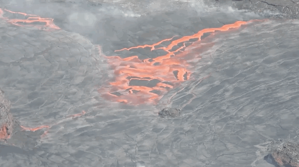
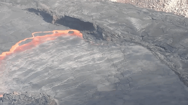
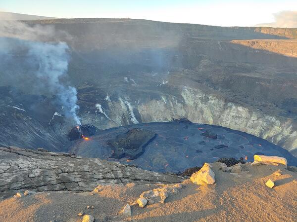
This preliminary thickness map of Kīlauea Volcano's 2018 lower East Rift Zone lava flows was calculated by subtracting pre-eruption ground surface elevations from post-eruption ground surface elevations mapped with USGS Unmanned Aerial System (drone) flights.
Images
Hawaiian Volcano Observatory images of eruptive activity, field work, and more.
This preliminary thickness map of Kīlauea Volcano's 2018 lower East Rift Zone lava flows was calculated by subtracting pre-eruption ground surface elevations from post-eruption ground surface elevations mapped with USGS Unmanned Aerial System (drone) flights.
pockets of natural gas from the burning plant material can ignite
pockets of natural gas from the burning plant material can igniteWhen molten lava encroaches on grassland, forests, or other vegetated land, subsurface pockets of natural gas from the burning plant material can ignite, causing a blast known as a "methane explosion." To avoid this hazard, keep a safe distance—at least tens of yards—from the margin of an active lava flow in vegetated areas.
The USGS Hawaiian Volcano Observatory continues to closely monitor volcanoes and earthquakes on the Island of Hawai‘i. On this map, which shows earthquakes that occurred beneath the island between August 6, 2018, and November 14, 2018, the size of each circle depicts earthquake magnitude and color indicates earthquake depth, relative to mean sea level.
Plot of ground motion as recorded by a GPS station at Kīlauea's summit (red) and the Pu‘u ‘Ō‘ō vent (blue) for the 8 months leading up to the 2018 eruption. Note the sharp increase indicating pressurization beginning in March. Image shows an aerial view of Halema‘uma‘u crater and the actively overflowing lava lake on April 23, 2018.
Explosive eruption columns of ash rising from Halema‘uma‘u at 11:15 a.m. on May 18, 1924 (top) and at 11:05 a.m. on May 15, 2018 (bottom) look similar.
Kīlauea Volcano’s 2018 summit collapse, shown here on July 28 (left), and the lower East Rift Zone fissure 8 lava flow, shown here on July 2 (right), will be the focus of “Volcano Awareness Month” talks offered in January 2019.
Continued degassing from fumaroles at fissures on Kīlauea Volcano's lower East Rift Zone produce native sulfur crystals when sulfur dioxide and hydrogen sulfide gases react and cool upon reaching the surface. The delicate sulfur crystals are 5–15 mm (0.2–0.6 in) long.
An aerial view of the prominent 1940 cinder-and-spatter cone on the floor of Mauna Loa's summit caldera. The cone, about 100 m (330 ft) high, was built during a 134-day-long eruption that began on April 7, 1940. Most of the caldera floor around the cone is covered by lava flows erupted in 1984.
New Hawaiian Volcano Observatory Deputy Scientist-in-Charge David Phillips and his wife Francine Coloma with Japan's iconic Mt. Fuji in the background.
progression of the magmatic intrusion from Kīlauea
progression of the magmatic intrusion from KīlaueaEarthquakes (red dots) track the progression of the magmatic intrusion from Kīlauea Volcano's middle East Rift Zone to the lower East Rift Zone between April 30 and May 3, 2018. Orange triangles show the locations of fissure 1 (right), which erupted on May 3, and Pu‘u ‘Ō‘ō (left).
A midwinter dawn at Halema‘uma‘u on Kīlauea. Steaming cracks tell of water and heat interacting beneath the summit caldera of the volcano. In the background, the first rays of sunlight illuminate Uēkahuna Bluff.
Geologist Matthew Patrick being interviewed on the Kīlauea lava-flo...
Geologist Matthew Patrick being interviewed on the Kīlauea lava-flo...HVO geologist Matthew Patrick being interviewed on the Kīlauea lava-flow field for a documentary about Hawaiian volcanism. Growing lava delta (left background) steaming at the point of ocean entry.
September 19, 2018 USGS photo of the south caldera of Kīlauea Volcano showing the main collapse area. The south Sulphur Bank is in the left side of the photo. Uēkahuna Bluff, from where this photo was taken, cuts across the bottom and lower right corner of the photo. After the collapse of 1868, the caldera floor may have looked something like this.
Sulfur dioxide and hydrogen sulfide gases themselves are not visible, but dramatic plumes are sometimes visible at Kīlauea Volcano's summit (shown here) and Pu‘u ‘Ō‘ō.
View into fissure 8 cone in Kīlauea Volcano's lower East Rift Zone
View into fissure 8 cone in Kīlauea Volcano's lower East Rift ZoneView into fissure 8 cone in Kīlauea Volcano's lower East Rift Zone, after lava drained away.
View into fissure 8 cone in Kīlauea Volcano's lower East Rift Zone
View into fissure 8 cone in Kīlauea Volcano's lower East Rift ZoneView into fissure 8 cone in Kīlauea Volcano's lower East Rift Zone, after lava drained away.
What is next for Kīlauea Volcano? This is a view of the summit area from the southwest, showing the collapsed area of Halema‘uma‘u and the adjacent caldera floor. A section of Crater Rim Drive preserved on a down-dropped block is visible at the far right.
panoramic view, Hawai‘i Volcanoes National Park's Crater Rim Drive
panoramic view, Hawai‘i Volcanoes National Park's Crater Rim DriveIn this panoramic view, Hawai‘i Volcanoes National Park's Crater Rim Drive (left foreground) disappears into the enormous void created by the collapse of Halema‘uma‘u and portions of the Kīlauea caldera floor during the dramatic events at the summit of the volcano in May-August 2018.
USGS Hawaiian Volcano Observatory staff, September 2018.
USGS Hawaiian Volcano Observatory staff, September 2018.USGS Hawaiian Volcano Observatory staff, September 2018.
USGS Hawaiian Volcano Observatory staff, September 2018.
USGS Hawaiian Volcano Observatory staff, September 2018.USGS Hawaiian Volcano Observatory staff, September 2018.
In mid-July 2018, fissure 8 (shown here) on Kīlauea Volcano's lower East Rift Zone was emitting more than 50,000 tons of sulfur dioxide gas per day, creating high levels of vog on the island. Since early August, lower East Rift Zone SO2 emissions have dropped to less than 100 tons per day, resulting in better air quality for Hawaii.
At Kīlauea's summit today, a clear morning gave way to heavy rain, which re-mobilized the ash cover between HVO and the Southwest Rift Zone, concentrating the ash in washes.
Kīlauea Volcano’s summit, seen here from the northeast rim of the caldera, has remained quiet, with no collapse events since August 2. It remains too soon to tell if this diminished activity represents a temporary lull or the end of summit collapses.