



This image was taken by the S2cam during episode 32 of the ongoing Kīlauea summit eruption, on September 2, 2025. The S2cam is a temporary webcamera positioned on the south rim of Kaluapele (Kīlauae summit caldera) and the view is to the west. USGS webcam image.
Images
Hawaiian Volcano Observatory images of eruptive activity, field work, and more.
Filter Total Items: 4151
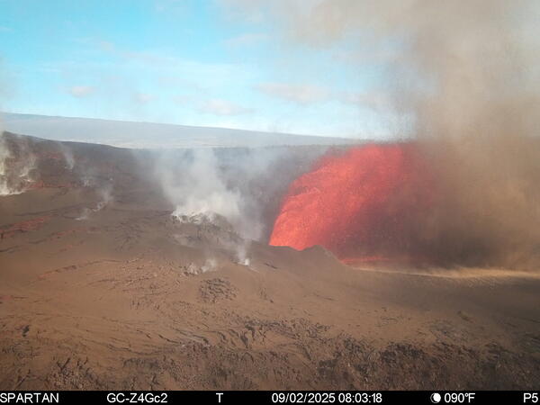
S2cam view of Kīlauea summit eruption episode 32
This image was taken by the S2cam during episode 32 of the ongoing Kīlauea summit eruption, on September 2, 2025. The S2cam is a temporary webcamera positioned on the south rim of Kaluapele (Kīlauae summit caldera) and the view is to the west. USGS webcam image.
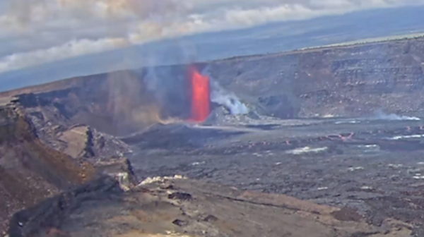
S2cam image of eruption at Kīlauea summit
This image was taken by the S2cam during the ongoing Kīlauea summit eruption, and it has been cropped from the original version. The S2cam is a temporary webcamera positioned on the south rim of Kaluapele (Kīlauae summit caldera) and the view is to the west. USGS webcam image. USGS photo.
This image was taken by the S2cam during the ongoing Kīlauea summit eruption, and it has been cropped from the original version. The S2cam is a temporary webcamera positioned on the south rim of Kaluapele (Kīlauae summit caldera) and the view is to the west. USGS webcam image. USGS photo.
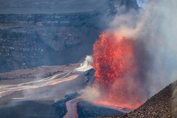
September 2, 2025 — Kīlauea summit eruption episode 32
September 2, 2025 — Kīlauea summit eruption episode 32From the Kīlauea Overlook within Hawaiʻi Volcanoes National Park, USGS Hawaiian Volcano Observatory scientists documented episode 32 of the Kīlauea summit eruption that began on December 23, 2025.
September 2, 2025 — Kīlauea summit eruption episode 32
September 2, 2025 — Kīlauea summit eruption episode 32From the Kīlauea Overlook within Hawaiʻi Volcanoes National Park, USGS Hawaiian Volcano Observatory scientists documented episode 32 of the Kīlauea summit eruption that began on December 23, 2025.
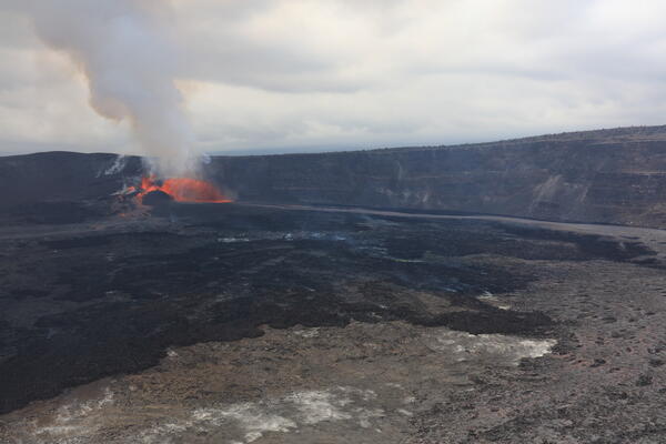
September 2, 2025 — Kīlauea summit aerial overview during episode 32
September 2, 2025 — Kīlauea summit aerial overview during episode 32Aerial view of the episode 32 lava fountain within Halema‘uma‘u during a USGS Hawaiian Volcano Observatory monitoring helicopter overflight at approximately 1:00 pm on September 2, 2025. Three vents were erupting from the western side of Halemaʻumaʻu, and feeding lava flows into the western side of the crater.
September 2, 2025 — Kīlauea summit aerial overview during episode 32
September 2, 2025 — Kīlauea summit aerial overview during episode 32Aerial view of the episode 32 lava fountain within Halema‘uma‘u during a USGS Hawaiian Volcano Observatory monitoring helicopter overflight at approximately 1:00 pm on September 2, 2025. Three vents were erupting from the western side of Halemaʻumaʻu, and feeding lava flows into the western side of the crater.
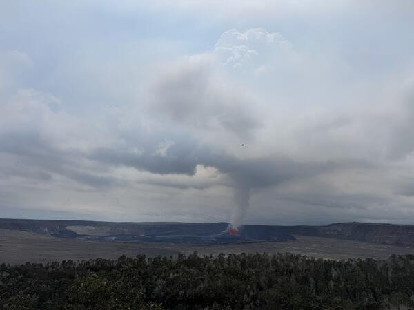
September 2, 2025 — Aerial photo of episode 32 lava fountain, Kīlauea summit
September 2, 2025 — Aerial photo of episode 32 lava fountain, Kīlauea summitUSGS Hawaiian Volcano Observatory scientists conducted an overflight of Kīlauea summit to conduct an aerial photo survey and collect lava samples of the current episode. This photo shows the helicopter passing in front of the outgassing plume on its way into the caldera. USGS photo by M. Patrick.
September 2, 2025 — Aerial photo of episode 32 lava fountain, Kīlauea summit
September 2, 2025 — Aerial photo of episode 32 lava fountain, Kīlauea summitUSGS Hawaiian Volcano Observatory scientists conducted an overflight of Kīlauea summit to conduct an aerial photo survey and collect lava samples of the current episode. This photo shows the helicopter passing in front of the outgassing plume on its way into the caldera. USGS photo by M. Patrick.
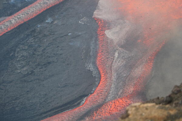
September 2, 2025 —Lava flows during Kīlauea summit eruption episode 32
September 2, 2025 —Lava flows during Kīlauea summit eruption episode 32Lava fountaining from the north vent during episode 32 of Kīlauea's summit eruption fed a wide channel on Halemaʻumaʻu crater floor. USGS photo by N. Kohagura.
September 2, 2025 —Lava flows during Kīlauea summit eruption episode 32
September 2, 2025 —Lava flows during Kīlauea summit eruption episode 32Lava fountaining from the north vent during episode 32 of Kīlauea's summit eruption fed a wide channel on Halemaʻumaʻu crater floor. USGS photo by N. Kohagura.
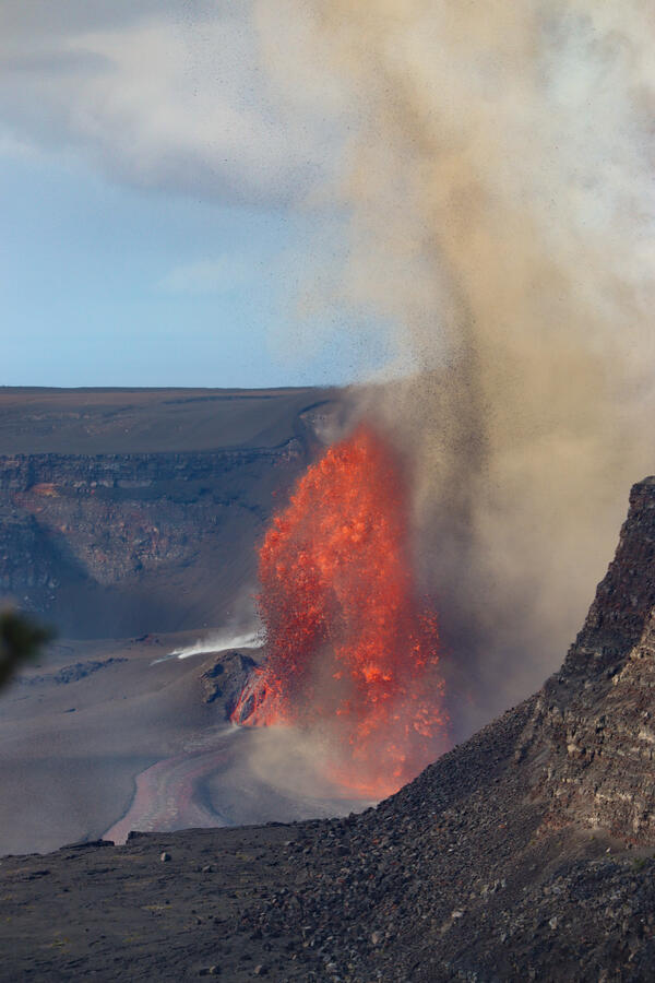
September 2, 2025 — Kīlauea summit eruption episode 32
September 2, 2025 — Kīlauea summit eruption episode 32USGS Hawaiian Volcano Observatory scientists documented episode 32 of Kīlauea's ongoing summit eruption from the Kīlauea Overlook within Hawaiʻi Volcanoes National Park. There, tephra from the lava fountain was visibly lofted high into the air by buoyant degassing during the eruption. USGS photo by C. Cauley.
September 2, 2025 — Kīlauea summit eruption episode 32
September 2, 2025 — Kīlauea summit eruption episode 32USGS Hawaiian Volcano Observatory scientists documented episode 32 of Kīlauea's ongoing summit eruption from the Kīlauea Overlook within Hawaiʻi Volcanoes National Park. There, tephra from the lava fountain was visibly lofted high into the air by buoyant degassing during the eruption. USGS photo by C. Cauley.
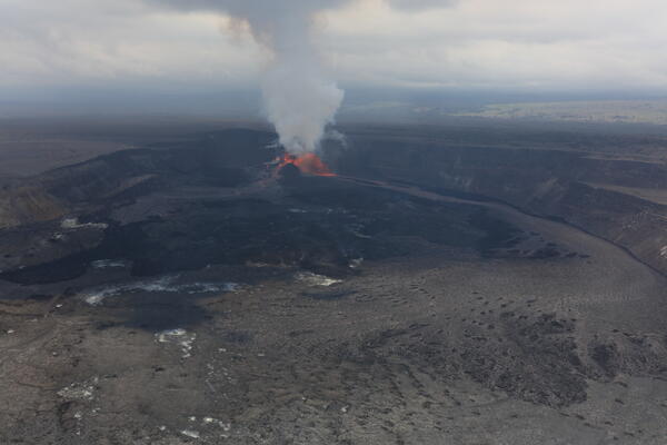
September 2, 2025 — Aerial photo of episode 32 lava fountain, Kīlauea summit
September 2, 2025 — Aerial photo of episode 32 lava fountain, Kīlauea summitUSGS Hawaiian Volcano Observatory scientists conducted an aerial overflight during episode 32 of the ongoing Kīlauea summit eruption. This view, taken at approximately 12:45 p.m. HST on September 2, 2025, shows three vents erupting from the western side of Halemaʻumaʻu, with lava flows reaching close to the eastern side of the crater floor. USGS photo by D.
September 2, 2025 — Aerial photo of episode 32 lava fountain, Kīlauea summit
September 2, 2025 — Aerial photo of episode 32 lava fountain, Kīlauea summitUSGS Hawaiian Volcano Observatory scientists conducted an aerial overflight during episode 32 of the ongoing Kīlauea summit eruption. This view, taken at approximately 12:45 p.m. HST on September 2, 2025, shows three vents erupting from the western side of Halemaʻumaʻu, with lava flows reaching close to the eastern side of the crater floor. USGS photo by D.
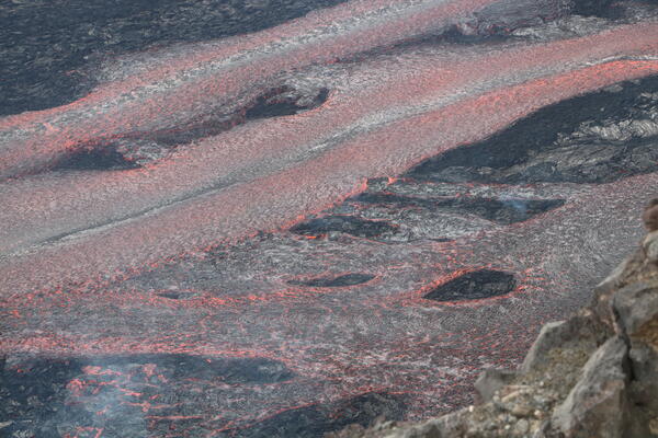
September 2, 2025 — Lava flows on the floor of Halemaʻumaʻu at the summit of Kīlauea
September 2, 2025 — Lava flows on the floor of Halemaʻumaʻu at the summit of KīlaueaVigorous lava fountaining during episode 32 of the ongoing Kīlauea summit eruption, on September 2, 2025, fed multiple lava channels on Halemaʻumaʻu crater floor. These lava channels transported erupted material from the west part of the crater, where the eruption was occuring, to the east side of the crater. USGS photo by N. Kohagura.
September 2, 2025 — Lava flows on the floor of Halemaʻumaʻu at the summit of Kīlauea
September 2, 2025 — Lava flows on the floor of Halemaʻumaʻu at the summit of KīlaueaVigorous lava fountaining during episode 32 of the ongoing Kīlauea summit eruption, on September 2, 2025, fed multiple lava channels on Halemaʻumaʻu crater floor. These lava channels transported erupted material from the west part of the crater, where the eruption was occuring, to the east side of the crater. USGS photo by N. Kohagura.
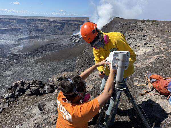
August 29, 2025 — Kīlauea summit observations and monitoring site maintenance
August 29, 2025 — Kīlauea summit observations and monitoring site maintenanceUSGS Hawaiian Volcano Observatory Scientists visited the V1cam livestream camera site on the morning of August 29 for some maintenance work.
August 29, 2025 — Kīlauea summit observations and monitoring site maintenance
August 29, 2025 — Kīlauea summit observations and monitoring site maintenanceUSGS Hawaiian Volcano Observatory Scientists visited the V1cam livestream camera site on the morning of August 29 for some maintenance work.
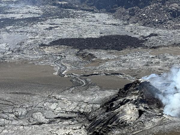
August 29, 2025 — Kīlauea summit observations and monitoring site maintenance
August 29, 2025 — Kīlauea summit observations and monitoring site maintenanceThe ongoing Kīlauea summit eruption within Halema‘uma‘u crater remains paused following the end of episode 31 on August 23. Intermittent glow is visible from the north vent (lower right) in nighttime views. Small lava channels are visible near the center of this telephoto image cutting through the tephra blanket on the western crater floor.
August 29, 2025 — Kīlauea summit observations and monitoring site maintenance
August 29, 2025 — Kīlauea summit observations and monitoring site maintenanceThe ongoing Kīlauea summit eruption within Halema‘uma‘u crater remains paused following the end of episode 31 on August 23. Intermittent glow is visible from the north vent (lower right) in nighttime views. Small lava channels are visible near the center of this telephoto image cutting through the tephra blanket on the western crater floor.
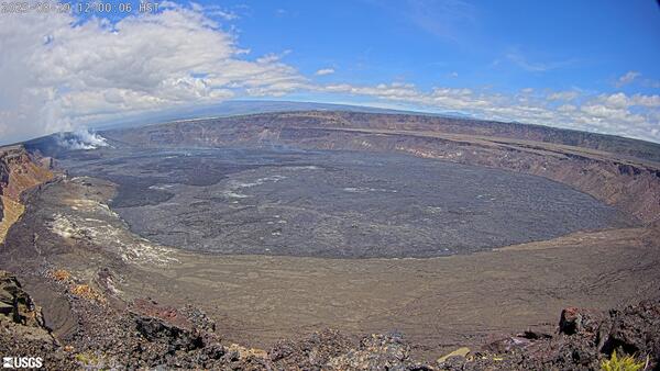
Kīlauea summit caldera from B1 camera on August 29, 2025
Kīlauea summit caldera from B1 camera on August 29, 2025View of Kaluapele (Kīlauea's summit caldera) from the B1 webcam on August 29, 2025, acquired between lava fountaining episodes 31 and 32.
Kīlauea summit caldera from B1 camera on August 29, 2025
Kīlauea summit caldera from B1 camera on August 29, 2025View of Kaluapele (Kīlauea's summit caldera) from the B1 webcam on August 29, 2025, acquired between lava fountaining episodes 31 and 32.
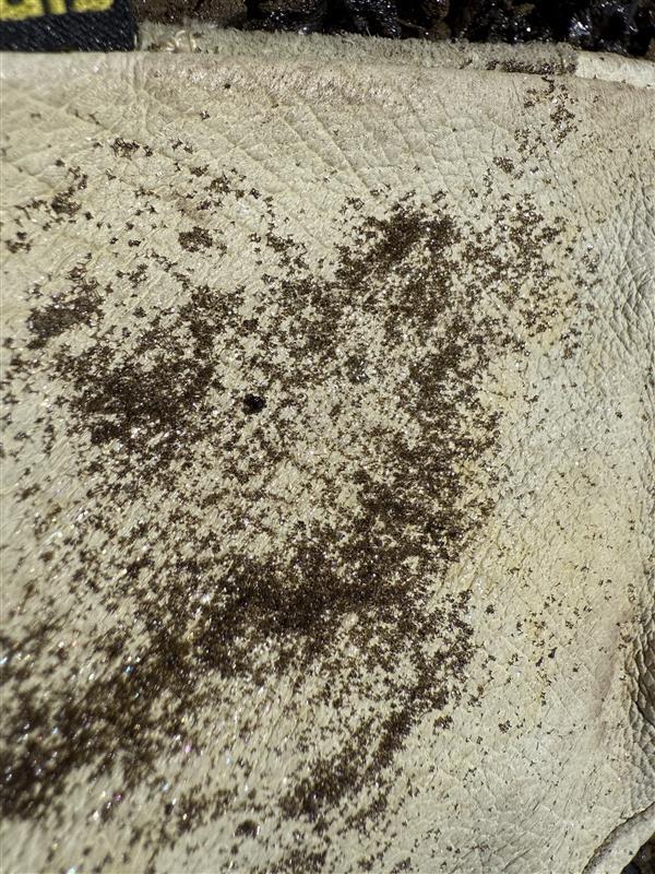
August 29, 2025 — Kīlauea summit observations and monitoring site maintenance
August 29, 2025 — Kīlauea summit observations and monitoring site maintenanceA close-up view of tiny volcanic glass fragments on a leather glove. These particles are abundant around the western rim of Kīlauea summit caldera, an area that is closed to the public due to hazardous conditions. Volcanic glass fragments can cause irritation to eyes, lungs, and skin, and exposure should be avoided.
August 29, 2025 — Kīlauea summit observations and monitoring site maintenance
August 29, 2025 — Kīlauea summit observations and monitoring site maintenanceA close-up view of tiny volcanic glass fragments on a leather glove. These particles are abundant around the western rim of Kīlauea summit caldera, an area that is closed to the public due to hazardous conditions. Volcanic glass fragments can cause irritation to eyes, lungs, and skin, and exposure should be avoided.
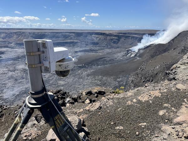
August 29, 2025 — V1cam at the summit of Kīlauea
On the morning of August 29, 2025, USGS Hawaiian Volcano Observatory scientists visited the V1cam livestream camera (left) on the northwest rim of Kaluapele (Kīlauea summit caldera) for some site maintenance. The camera provides critical views of the ongoing Kīlauea summit eruption, particularly of the north vent, used for volcano monitoring. USGS photo by M.
On the morning of August 29, 2025, USGS Hawaiian Volcano Observatory scientists visited the V1cam livestream camera (left) on the northwest rim of Kaluapele (Kīlauea summit caldera) for some site maintenance. The camera provides critical views of the ongoing Kīlauea summit eruption, particularly of the north vent, used for volcano monitoring. USGS photo by M.

August 29, 2025—Kīlauea summit eruption reference map
August 29, 2025—Kīlauea summit eruption reference mapThis reference map depicts the Kīlauea summit eruption within Halema‘uma‘u crater that began on December 23, 2024. As of this posting on August 29, 2025, the eruption has had thirty-one episodes, with the most recent one occurring on August 22 and 23.
August 29, 2025—Kīlauea summit eruption reference map
August 29, 2025—Kīlauea summit eruption reference mapThis reference map depicts the Kīlauea summit eruption within Halema‘uma‘u crater that began on December 23, 2024. As of this posting on August 29, 2025, the eruption has had thirty-one episodes, with the most recent one occurring on August 22 and 23.
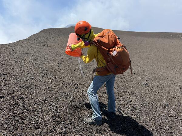
August 29, 2025 — Kīlauea summit observations and monitoring site maintenance
August 29, 2025 — Kīlauea summit observations and monitoring site maintenanceA USGS Hawaiian Volcano Observatory scientist empties water and volcanic glass particles from a tephra collection bucket on the western rim of Halema‘uma‘u. The buckets are used to collect tephra from the eruption episodes for geochemical analyses.
August 29, 2025 — Kīlauea summit observations and monitoring site maintenance
August 29, 2025 — Kīlauea summit observations and monitoring site maintenanceA USGS Hawaiian Volcano Observatory scientist empties water and volcanic glass particles from a tephra collection bucket on the western rim of Halema‘uma‘u. The buckets are used to collect tephra from the eruption episodes for geochemical analyses.
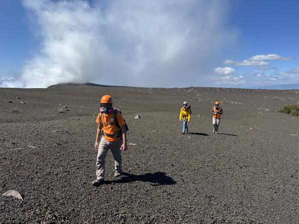
August 29, 2025 — Kīlauea summit observations and monitoring site maintenance
August 29, 2025 — Kīlauea summit observations and monitoring site maintenanceUSGS Hawaiian Volcano Observatory Scientists hike to the northwest rim of Kaluapele (Kīlauea summit caldera) for maintenance at the V1cam livestream camera. The crew wears special personal protective equipment (PPE) to protect their eyes and lungs from exposure to tiny volcanic glass particles.
August 29, 2025 — Kīlauea summit observations and monitoring site maintenance
August 29, 2025 — Kīlauea summit observations and monitoring site maintenanceUSGS Hawaiian Volcano Observatory Scientists hike to the northwest rim of Kaluapele (Kīlauea summit caldera) for maintenance at the V1cam livestream camera. The crew wears special personal protective equipment (PPE) to protect their eyes and lungs from exposure to tiny volcanic glass particles.

August 25, 2025 — Kīlauea caldera and degassing plume views
August 25, 2025 — Kīlauea caldera and degassing plume viewsClear weather provided good conditions for a helicopter overflight of Kīlauea summit the morning of August 25, 2025. The overflight allowed USGS Hawaiian Volcano Observatory geologists to conduct a photogrammetric survey of the crater floor following the episode 31 lava fountaining late last week, as well as to collect lava samples.
August 25, 2025 — Kīlauea caldera and degassing plume views
August 25, 2025 — Kīlauea caldera and degassing plume viewsClear weather provided good conditions for a helicopter overflight of Kīlauea summit the morning of August 25, 2025. The overflight allowed USGS Hawaiian Volcano Observatory geologists to conduct a photogrammetric survey of the crater floor following the episode 31 lava fountaining late last week, as well as to collect lava samples.
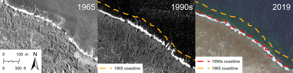
Changes to Kīlauea 1960 lava delta over time
Aerial imagery time-series showing erosion along the northern edge of the 1960 lava delta spanning six decades after the eruption. The 1965 aerial photo on the left is from the U.S. Department of Agriculture, the 1990s satellite image in the center is from Spot Image, and the 2019 satellite image is from Maxar.
Aerial imagery time-series showing erosion along the northern edge of the 1960 lava delta spanning six decades after the eruption. The 1965 aerial photo on the left is from the U.S. Department of Agriculture, the 1990s satellite image in the center is from Spot Image, and the 2019 satellite image is from Maxar.

August 25, 2025 — Thermal map of Kīlauea summit following episode 31 lava flows
August 25, 2025 — Thermal map of Kīlauea summit following episode 31 lava flowsThis thermal map of Kīlauea's summit caldera was made from airborne thermal images collected on August 25, just a few days after episode 31 lava fountaining covered Halemaʻumaʻu crater floor in new lava flows. These flows remain warm in the thermal imagery, particularly in the eastern crater where flows slightly expanded the margin of new flows on the crater floor.
August 25, 2025 — Thermal map of Kīlauea summit following episode 31 lava flows
August 25, 2025 — Thermal map of Kīlauea summit following episode 31 lava flowsThis thermal map of Kīlauea's summit caldera was made from airborne thermal images collected on August 25, just a few days after episode 31 lava fountaining covered Halemaʻumaʻu crater floor in new lava flows. These flows remain warm in the thermal imagery, particularly in the eastern crater where flows slightly expanded the margin of new flows on the crater floor.
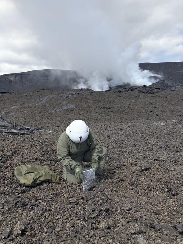
August 25, 2025 — Sampling episode 31 tephra and lava in Halemaʻumaʻu at the summit of Kīlauea
August 25, 2025 — Sampling episode 31 tephra and lava in Halemaʻumaʻu at the summit of KīlaueaOn August 25, 2025, USGS Hawaiian Volcano Observatory field crews sampled lava and tephra from episode 31 during a morning monitoring overflight of Kīlauea summit. Samples from the episode will be later analyzed in the lab to track changes in the chemistry of erupted material and help scientists understand the processes driving the 2024-2025 episodic eruption.
August 25, 2025 — Sampling episode 31 tephra and lava in Halemaʻumaʻu at the summit of Kīlauea
August 25, 2025 — Sampling episode 31 tephra and lava in Halemaʻumaʻu at the summit of KīlaueaOn August 25, 2025, USGS Hawaiian Volcano Observatory field crews sampled lava and tephra from episode 31 during a morning monitoring overflight of Kīlauea summit. Samples from the episode will be later analyzed in the lab to track changes in the chemistry of erupted material and help scientists understand the processes driving the 2024-2025 episodic eruption.