U.S. flag

An official website of the United States government

Images

Hawaiian Volcano Observatory images of eruptive activity, field work, and more.

Filter Total Items: 4151
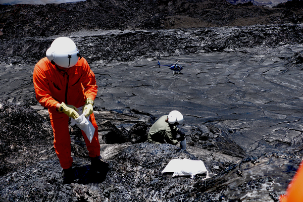
Color photograph of two scientists collecting a sample of spatter from the now cooling episode 30 eruption.
August 13, 2025 — Scientists sample spatter from a small fissure that occurred during Episode 30.

On August 13, USGS scientists collect recent spatter samples of episode 30 lava from a temporary fissure feature that appeared early in episode 30. The chemistry of these lava samples is analyzed to better understand the source and storage of magma driving Hawaiian eruptions. USGS photo by K. Mulliken 
On August 13, USGS scientists collect recent spatter samples of episode 30 lava from a temporary fissure feature that appeared early in episode 30. The chemistry of these lava samples is analyzed to better understand the source and storage of magma driving Hawaiian eruptions. USGS photo by K. Mulliken 
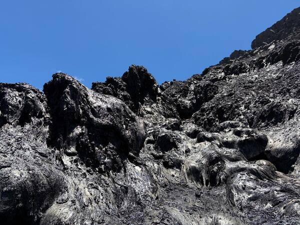
Color photo of black, cooling lava from the August 6th eruption episode 30 with the vents in the background.
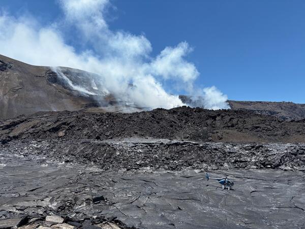
August 13, 2025 — Halemaʻumaʻu crater floor view looking north towards the vents

August 13 - View of the lava/tephra pile from the sampling location on the temporary fissure from episode 30. The helicopter landed on the crater floor on the new pāhoehoe lava that formed while the talus slope of the fissure vent was erupting. 

August 13 - View of the lava/tephra pile from the sampling location on the temporary fissure from episode 30. The helicopter landed on the crater floor on the new pāhoehoe lava that formed while the talus slope of the fissure vent was erupting. 

Color photograph of black cooling lava from the August 6th eruption.
August 13, 2025 — Spatter on the western wall of Halema‘uma‘u crater where samples were collected.

This image from August 13, 2025, shows spatter on the western wall of Halema‘uma‘u crater where samples were collected. No molten lava was visible during the overflight and the Kīlauea summit eruption remains paused. USGS photo by D. Downs

Color photograph of volcano monitoring site
August 12, 2025 — Mauna Loa monitoring network maintenance

On August 12, USGS-Hawaiian Volcano Observatory scientists visited the ML/MTcam monitoring site on the north side of Moku‘āweoweo—the summit caldera of Mauna Loa volcano. At the site, field engineers changed batteries, installed a new antenna, and replaced solar panels that had been damaged during winter storms. USGS photo by M. Cappos.

On August 12, USGS-Hawaiian Volcano Observatory scientists visited the ML/MTcam monitoring site on the north side of Moku‘āweoweo—the summit caldera of Mauna Loa volcano. At the site, field engineers changed batteries, installed a new antenna, and replaced solar panels that had been damaged during winter storms. USGS photo by M. Cappos.

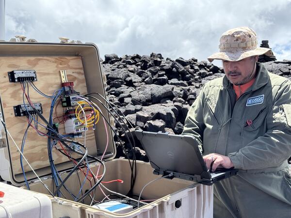
Color photograph of person working on monitoring equipment in the field
August 12, 2025 — Field engineer services Mauna Loa monitoring station

A USGS Hawaiian Volcano Observatory field engineer works on the infrastructure that supports the MLcam and MTcam on the north rim of Moku‘āweoweo, the summit caldera of Mauna Loa volcano. The MLcam provides visual imagery of Moku‘āweoweo while the MTcam provides thermal imagery.

A USGS Hawaiian Volcano Observatory field engineer works on the infrastructure that supports the MLcam and MTcam on the north rim of Moku‘āweoweo, the summit caldera of Mauna Loa volcano. The MLcam provides visual imagery of Moku‘āweoweo while the MTcam provides thermal imagery.

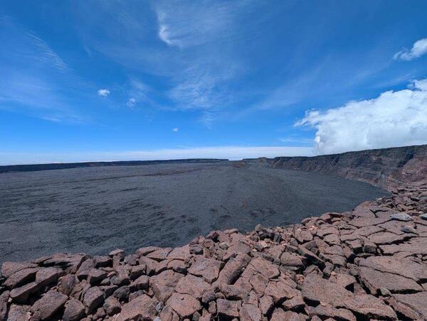
Color photograph of caldera with blue sky in the background
August 12, 2025 — Moku‘āweoweo caldera, Mauna Loa volcano

A view of Moku‘āweoweo, the summit caldera of Mauna Loa, taken from the north rim on August 12, 2025. 

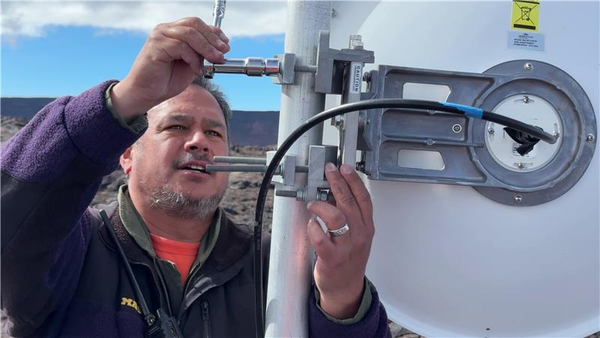
Color image of field engineer installing new antenna
August 12, 2025 — Installing antenna at Mauna Loa monitoring station

A USGS Hawaiian Volcano Observatory field engineer installs a new antenna at the monitoring station located just southwest of Moku‘āweoweo, where the MOcam and SPcam are located.

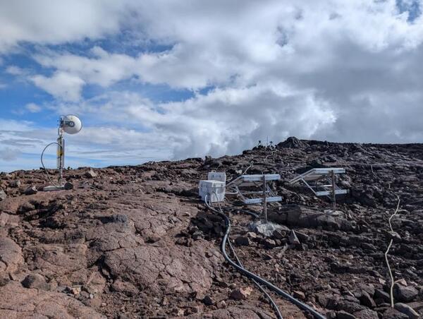
Color photograph of volcano monitoring equipment on lava flows
August 12, 2025 — SPcam and MSTcam on Mauna Loa

The SPcam (wide angle visual webcam) and MSTcam (thermal camera) are situated next to one another in the summit region of Mauna Loa. Both cameras look south to monitor the uppermost Southwest Rift Zone of Mauna Loa. USGS photo by M. Patrick. 

The SPcam (wide angle visual webcam) and MSTcam (thermal camera) are situated next to one another in the summit region of Mauna Loa. Both cameras look south to monitor the uppermost Southwest Rift Zone of Mauna Loa. USGS photo by M. Patrick. 

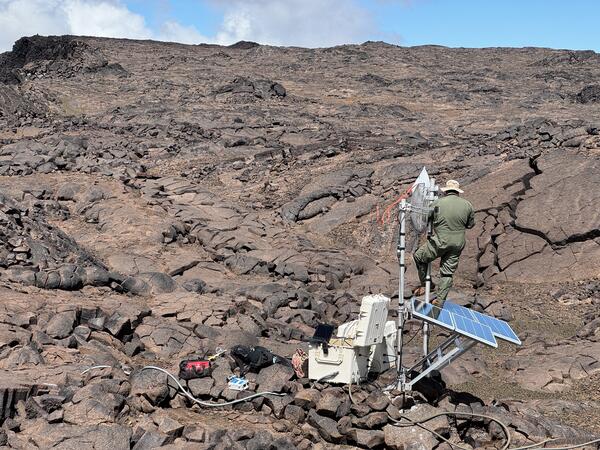
Color photograph of field engineer working on remote volcano monitoring station located on a lava flow
August 12, 2025 — Servicing Mauna Loa monitoring station

The telemetry network was upgraded yesterday, August 12, 2025, on Mauna Loa to accommodate new webcams around the summit and upper Southwest Rift Zone.  Here, an HVO field engineer installs a new antenna that will allow for more efficient transfer of volcano monitoring datasets from remote stations back to the USGS Hawaiian Volcano Observatory.

The telemetry network was upgraded yesterday, August 12, 2025, on Mauna Loa to accommodate new webcams around the summit and upper Southwest Rift Zone.  Here, an HVO field engineer installs a new antenna that will allow for more efficient transfer of volcano monitoring datasets from remote stations back to the USGS Hawaiian Volcano Observatory.

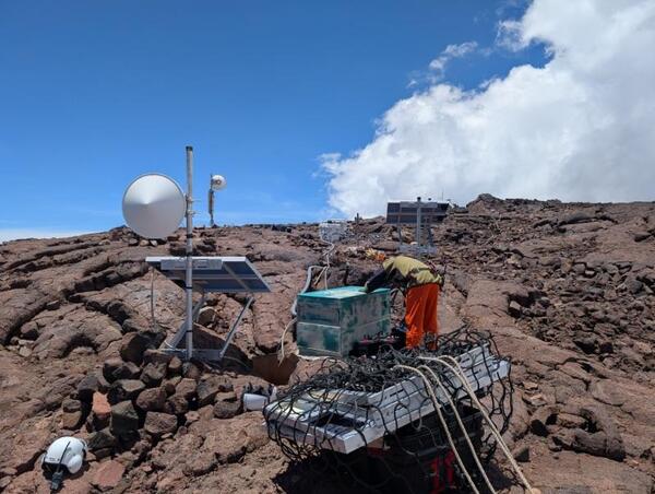
Color photograph of field engineer servicing a remote volcano monitoring site
August 12, 2025 — Upgrading volcano monitoring webcams in the summit region of Mauna Loa

A USGS Hawaiian Volcano Observatory field engineer updates the infrastructure at a remote station in the summit region of Mauna Loa. At this location, two webcams (MOcam and SPcam) were upgraded and a new thermal webcam, the MSTcam, was installed on Mauna Loa summit.  USGS photo by M. Patrick.

A USGS Hawaiian Volcano Observatory field engineer updates the infrastructure at a remote station in the summit region of Mauna Loa. At this location, two webcams (MOcam and SPcam) were upgraded and a new thermal webcam, the MSTcam, was installed on Mauna Loa summit.  USGS photo by M. Patrick.

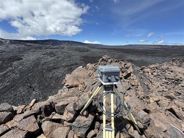
Color photograph of volcano monitoring webcam located on a lava flow near a crater edge
August 12, 2025 — MOcam upgrade on Mauna Loa

The MOcam webcam is situated in the south end of Mokuʻāweoweo, Mauna Loa's summit caldera, and it looks north to monitor the southern portion of the caldera floor.  Nearby, the SPcam is pointed south to monitor the uppermost Southwest Rift Zone of Mauna Loa. USGS photo by M. Patrick.

The MOcam webcam is situated in the south end of Mokuʻāweoweo, Mauna Loa's summit caldera, and it looks north to monitor the southern portion of the caldera floor.  Nearby, the SPcam is pointed south to monitor the uppermost Southwest Rift Zone of Mauna Loa. USGS photo by M. Patrick.

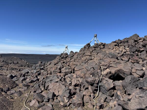
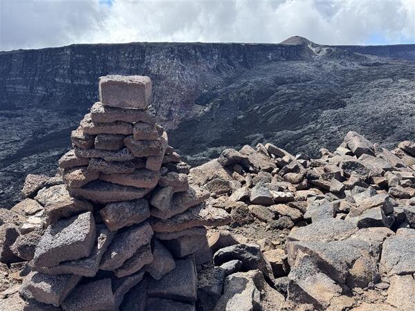
Color photograph of trail cairn near volcanic caldera
August 12, 2025 — Ahu near Mokuʻāweoweo

An ahu (cairn) marks the south end of Mokuʻāweoweo, the caldera at the summit of Mauna Loa.  This photo shows the cone that formed during the Mauna Loa summit eruption in 1949, in the upper right.

An ahu (cairn) marks the south end of Mokuʻāweoweo, the caldera at the summit of Mauna Loa.  This photo shows the cone that formed during the Mauna Loa summit eruption in 1949, in the upper right.

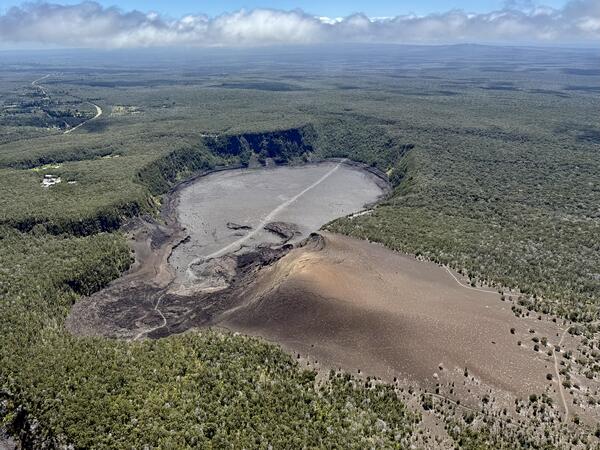
Color photograph of crater
August 8, 2025 — View of Kīlauea Iki

An aerial view of Kīlauea Iki and Pu‘u Pua‘i taken during a USGS Hawaiian Volcano Obsrvatory monitoring overflight of Kīlauea summit on August 8.

An aerial view of Kīlauea Iki and Pu‘u Pua‘i taken during a USGS Hawaiian Volcano Obsrvatory monitoring overflight of Kīlauea summit on August 8.

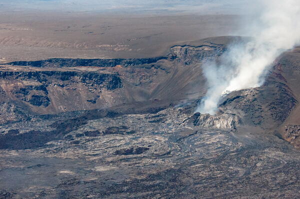
Color photograph of volcanic vent
August 8, 2025 — Halema‘uma‘u Crater Post Episode 30

An aerial image taken during a USGS Hawaiian Volcano Observatory monitoring overflight, following the end of episode 30 on August 6.

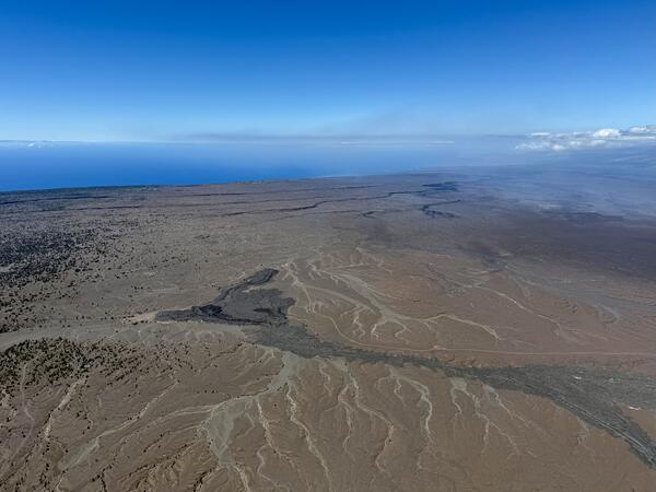
Color photograph of volcanic landscape and ocean in the distance
August 8, 2025 — View of Kīlauea South Flank

This aerial image, taken during a Kīlauea summit overflight on August 8, 2025, looks southwest towards the ocean. In the foreground, two small lava flows that were erupted from Kīlauea in 1982 and 1971 are visible. The darker one on the left is from September 1971, while the shiny grey one on the right is from September 1982.

This aerial image, taken during a Kīlauea summit overflight on August 8, 2025, looks southwest towards the ocean. In the foreground, two small lava flows that were erupted from Kīlauea in 1982 and 1971 are visible. The darker one on the left is from September 1971, while the shiny grey one on the right is from September 1982.

Color photograph of lava fountain at night
August 6, 2025 — Episode 30 at night

Early in the morning on August 6, Hawaiian Volcano Observatory geologists visited the western rim of Halemaʻumaʻu crater to observe Kīlauea summit eruption episode 30. Lava fountains were reaching about 70 meters (230 feet) above the north vent at the time. USGS photo by N. Deligne.

Early in the morning on August 6, Hawaiian Volcano Observatory geologists visited the western rim of Halemaʻumaʻu crater to observe Kīlauea summit eruption episode 30. Lava fountains were reaching about 70 meters (230 feet) above the north vent at the time. USGS photo by N. Deligne.

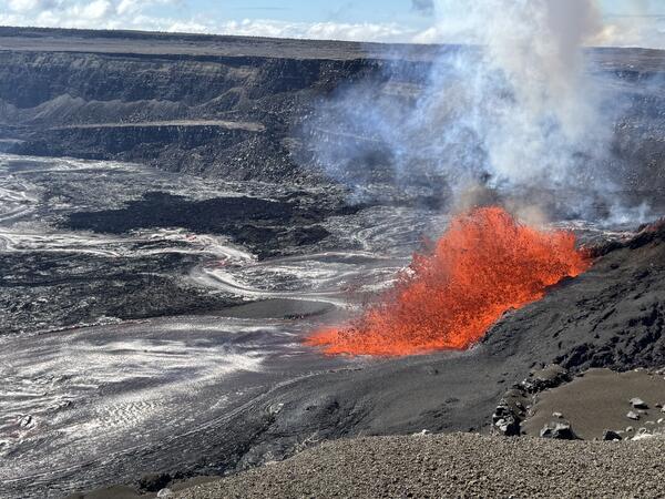
Lava fountaining from a vent in the crater wall
Episode 30 lava fountaining at Kīlauea summit

A view of the episode 30 lava fountaining in the north vent, taken from the west rim of Kaluapele, Kīlauea's summit caldera. The fountaining was sending out several lava channels across the crater floor, with lava flows reaching the eastern portion of Halema‘uma‘u crater. USGS photo taken by M. Patrick on August 6, 2025.

A view of the episode 30 lava fountaining in the north vent, taken from the west rim of Kaluapele, Kīlauea's summit caldera. The fountaining was sending out several lava channels across the crater floor, with lava flows reaching the eastern portion of Halema‘uma‘u crater. USGS photo taken by M. Patrick on August 6, 2025.

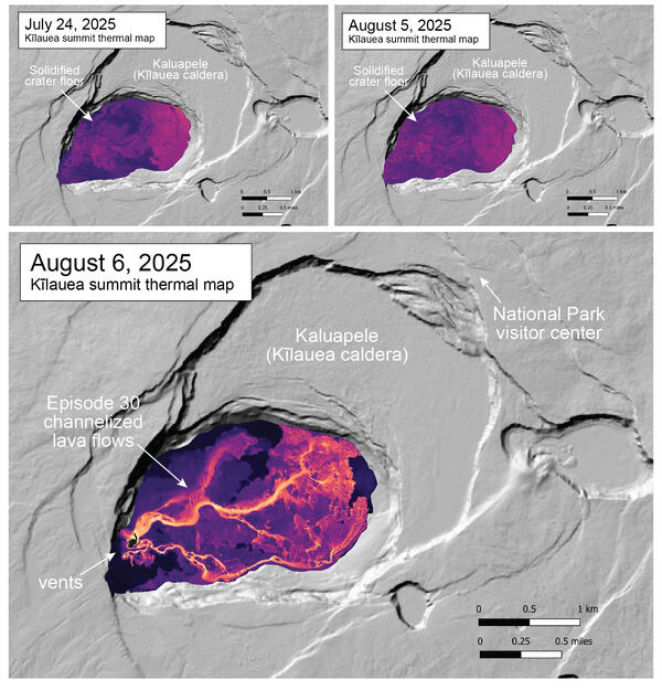
Color maps showing temperature of caldera floor where there is an ongoing eruption
August 6, 2025 — Thermal map of Kīlauea episode 30 lava flows

The August 6 thermal map shows the widespread channelized lava flows covering the crater floor, originating from the episode 30 lava fountaining in the western end of Halema‘uma‘u crater at the summit of Kīlauea. Most of the lava originated from the vigorous fountaining at the north vent, with the weak fountaining at the south vent contributing a smaller volume.

The August 6 thermal map shows the widespread channelized lava flows covering the crater floor, originating from the episode 30 lava fountaining in the western end of Halema‘uma‘u crater at the summit of Kīlauea. Most of the lava originated from the vigorous fountaining at the north vent, with the weak fountaining at the south vent contributing a smaller volume.

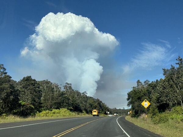
Color photograph of volcanic plume rising above road
August 6, 2025 — Kīlauea episode 30 plume

Slack winds allowed the outgassing plume from the episode 30 lava fountaining to rise vertically above Kīlauea summit caldera, making it easily visible from Highway 11. USGS photo by M. Patrick.

Slack winds allowed the outgassing plume from the episode 30 lava fountaining to rise vertically above Kīlauea summit caldera, making it easily visible from Highway 11. USGS photo by M. Patrick.

Color photograph of sinkhole deposit in a volcanic landscape
August 6, 2025 — sinkhole at the summit of Kīlauea

On the south rim of Halemaʻumaʻu, new sink holes in ash and tephra that blankets the ground in this area were observed following episode 30 of the Kīlauea summit eruption on August 6. The sinkholes formed due to underlying cracks that opened as a result of the new fissure in the south wall of the caldera. USGS photo by M. Patrick. 

On the south rim of Halemaʻumaʻu, new sink holes in ash and tephra that blankets the ground in this area were observed following episode 30 of the Kīlauea summit eruption on August 6. The sinkholes formed due to underlying cracks that opened as a result of the new fissure in the south wall of the caldera. USGS photo by M. Patrick. 

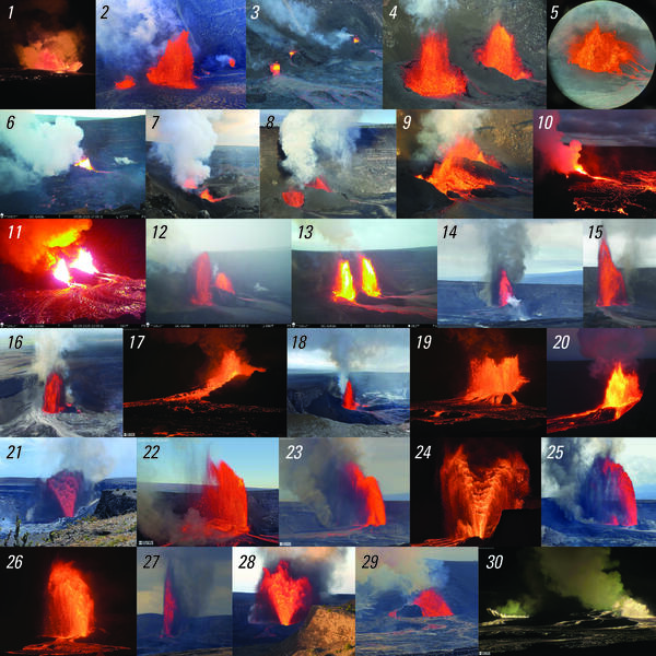
Color photo compilation of many images
August 7, 2025 — Photo compilation of episodes 1–30 of the ongoing eruption at the summit of Kīlauea

Photo compilation of episodes 1–30 of the ongoing eruption at the summit of Kīlauea, including webcam imagery and photos taken by USGS Hawaiian Volcano Observatory scientists on the ground and during helicopter overflights. In all photos except for episode 7, the south vent is on the left and the north vent is on the right.

Photo compilation of episodes 1–30 of the ongoing eruption at the summit of Kīlauea, including webcam imagery and photos taken by USGS Hawaiian Volcano Observatory scientists on the ground and during helicopter overflights. In all photos except for episode 7, the south vent is on the left and the north vent is on the right.

Was this page helpful?