



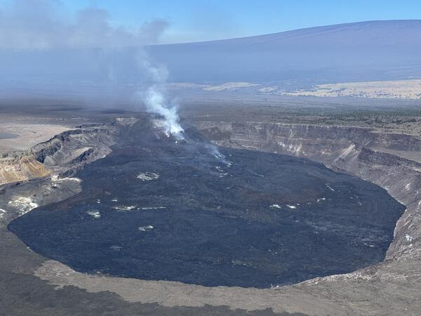
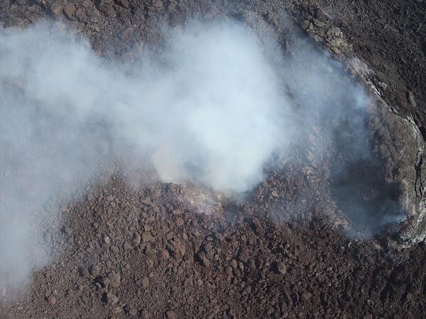
This closer view of Halema‘uma‘u crater at the summit of Kīlauea was captured during the Hawaiian Volcano Observatory's helicopter overflight on August 5. The circular black zone consists of recent lava flows that have been filling the crater in recent months, and the outgassing plume from the eruptive vents is carried southwest by the trade winds. USGS photo by M.
Images
Hawaiian Volcano Observatory images of eruptive activity, field work, and more.
Filter Total Items: 4163
August 5, 2025 — Overview of Halema‘uma‘u
This closer view of Halema‘uma‘u crater at the summit of Kīlauea was captured during the Hawaiian Volcano Observatory's helicopter overflight on August 5. The circular black zone consists of recent lava flows that have been filling the crater in recent months, and the outgassing plume from the eruptive vents is carried southwest by the trade winds. USGS photo by M.
August 5, 2025 — Laser rangefinder measurements of north vent
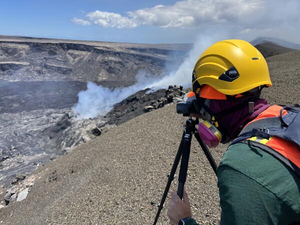
August 5, 2025 — Laser rangefinder measurements of north ventOn August 5, USGS geologists used a laser rangefinder to measure the elevation of the small lava pond spotted today within the Halema‘uma‘u north vent at the summit of Kīlauea. USGS photo by M. Patrick.
August 5, 2025 — Laser rangefinder measurements of north vent
August 5, 2025 — Laser rangefinder measurements of north ventOn August 5, USGS geologists used a laser rangefinder to measure the elevation of the small lava pond spotted today within the Halema‘uma‘u north vent at the summit of Kīlauea. USGS photo by M. Patrick.
August 5, 2025 — Overview of Halemaʻumaʻu eruptive vents
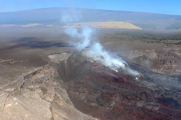
August 5, 2025 — Overview of Halemaʻumaʻu eruptive ventsThis aerial view of the complex tephra cone built in recent months around the Halemaʻumaʻu eruptive vents was captured on August 5. The cone has been built against the western wall of Kaluapele (Kīlauea caldera), with tephra also forming a hill atop the caldera rim.
August 5, 2025 — Overview of Halemaʻumaʻu eruptive vents
August 5, 2025 — Overview of Halemaʻumaʻu eruptive ventsThis aerial view of the complex tephra cone built in recent months around the Halemaʻumaʻu eruptive vents was captured on August 5. The cone has been built against the western wall of Kaluapele (Kīlauea caldera), with tephra also forming a hill atop the caldera rim.
August 1, 2025—Kīlauea summit eruption reference map
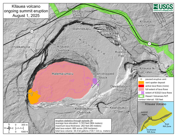
August 1, 2025—Kīlauea summit eruption reference mapThis reference map depicts the Kīlauea summit eruption within Halema‘uma‘u crater that began on December 23, 2024. As of this posting on August 1, 2025, the eruption has had twenty-nine episodes, with the most recent occurring on July 20.
August 1, 2025—Kīlauea summit eruption reference map
August 1, 2025—Kīlauea summit eruption reference mapThis reference map depicts the Kīlauea summit eruption within Halema‘uma‘u crater that began on December 23, 2024. As of this posting on August 1, 2025, the eruption has had twenty-nine episodes, with the most recent occurring on July 20.
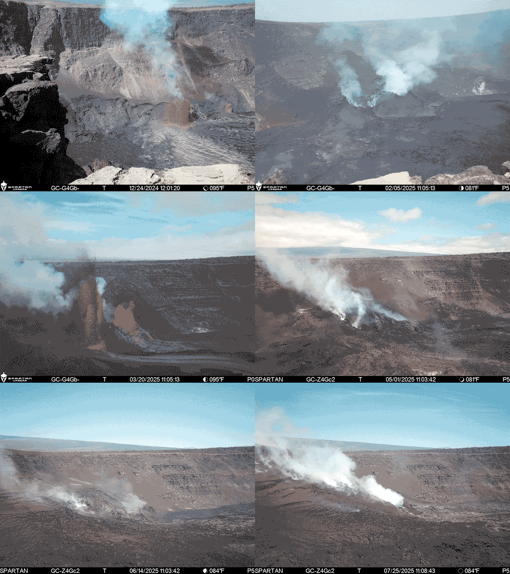
S2cam captures changes to the eruption site in Halemaʻumaʻu over the past 30 episodes
S2cam captures changes to the eruption site in Halemaʻumaʻu over the past 30 episodesThis animated GIF was created using an image collected approximately every other day by the S2cam located on the south rim of Halemaʻumaʻu crater. It shows how the vent geometry and near-vent eruption area within Halemaʻumaʻu crater has changed over the past 30 episodes of lava fountaining.
S2cam captures changes to the eruption site in Halemaʻumaʻu over the past 30 episodes
S2cam captures changes to the eruption site in Halemaʻumaʻu over the past 30 episodesThis animated GIF was created using an image collected approximately every other day by the S2cam located on the south rim of Halemaʻumaʻu crater. It shows how the vent geometry and near-vent eruption area within Halemaʻumaʻu crater has changed over the past 30 episodes of lava fountaining.
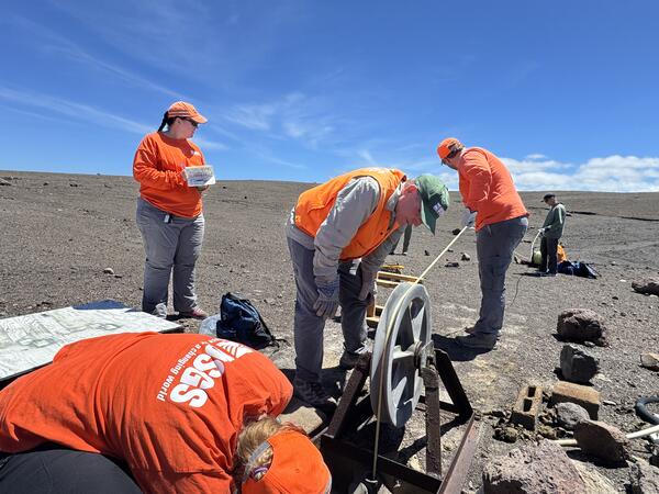
July 25, 2025 — Sampling Keller Well at the summit of Kīlauea
July 25, 2025 — Sampling Keller Well at the summit of KīlaueaOn July 25, 2025, USGS scientists measured the depth to the water table at the Keller Well, located south of Halema‘uma‘u crater. The Keller Well is a borehole drilled in 1973 to a depth of 4,140 ft (1,262 m); since then, it has been used to monitor the hydrology of the summit region of Kīlauea volcano. USGS photo by K. Mulliken.
July 25, 2025 — Sampling Keller Well at the summit of Kīlauea
July 25, 2025 — Sampling Keller Well at the summit of KīlaueaOn July 25, 2025, USGS scientists measured the depth to the water table at the Keller Well, located south of Halema‘uma‘u crater. The Keller Well is a borehole drilled in 1973 to a depth of 4,140 ft (1,262 m); since then, it has been used to monitor the hydrology of the summit region of Kīlauea volcano. USGS photo by K. Mulliken.
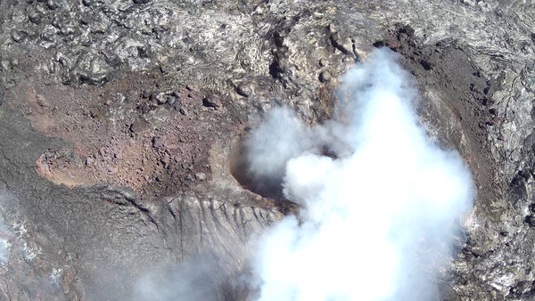
July 25, 2025 — UAS view of north vent
This oblique aerial view of the north vent within Halema‘uma‘u crater was captured during a USGS Hawaiian Volcano Observatory UAS (uncrewed aircraft systems) flight on July 25, 2025. The aircraft was flying about 150 m (500 ft) above the vent—about the height of the crater rim—with the image captured looking down to the northeast.
This oblique aerial view of the north vent within Halema‘uma‘u crater was captured during a USGS Hawaiian Volcano Observatory UAS (uncrewed aircraft systems) flight on July 25, 2025. The aircraft was flying about 150 m (500 ft) above the vent—about the height of the crater rim—with the image captured looking down to the northeast.
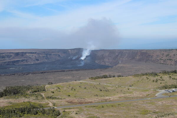
July 24, 2025 — Aerial overview of Kaluapele
USGS Hawaiian Volcano Observatory staff undertook a helicopter monitoring overflight of the summit of Kīlauea on July 24, 2025. This photo looking southwest shows the Steam Vents parking area in the bottom right with the trail to Wahinekapu (Steaming Bluff) going towards the middle of the photo.
USGS Hawaiian Volcano Observatory staff undertook a helicopter monitoring overflight of the summit of Kīlauea on July 24, 2025. This photo looking southwest shows the Steam Vents parking area in the bottom right with the trail to Wahinekapu (Steaming Bluff) going towards the middle of the photo.
July 24, 2025 — HVO scientist collects data during summit overflight of Kīlauea volcano
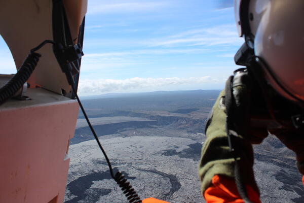
July 24, 2025 — HVO scientist collects data during summit overflight of Kīlauea volcanoA USGS Hawaiian Volcano Observatory scientist takes a series of photos at a constant angle and zoom during a summit overflight of Kīlauea volcano. These images are then processed using structure-from-motion photogrammetry methods to construct a new digital elevation model of the summit.
July 24, 2025 — HVO scientist collects data during summit overflight of Kīlauea volcano
July 24, 2025 — HVO scientist collects data during summit overflight of Kīlauea volcanoA USGS Hawaiian Volcano Observatory scientist takes a series of photos at a constant angle and zoom during a summit overflight of Kīlauea volcano. These images are then processed using structure-from-motion photogrammetry methods to construct a new digital elevation model of the summit.
July 24, 2025 — Low-angle view of crater complex within Halema‘uma‘u, Kīlauea volcano
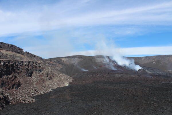
July 24, 2025 — Low-angle view of crater complex within Halema‘uma‘u, Kīlauea volcanoThis low-angle view of the crater complex that has built up since December 23, 2024, in western Halema‘uma‘u, was captured during a USGS Hawaiian Volcano Observatory monitoring helicopter overflight of Kīlauea volcano on July 24, 2025. The north vent is degassing on the right side of photo.
July 24, 2025 — Low-angle view of crater complex within Halema‘uma‘u, Kīlauea volcano
July 24, 2025 — Low-angle view of crater complex within Halema‘uma‘u, Kīlauea volcanoThis low-angle view of the crater complex that has built up since December 23, 2024, in western Halema‘uma‘u, was captured during a USGS Hawaiian Volcano Observatory monitoring helicopter overflight of Kīlauea volcano on July 24, 2025. The north vent is degassing on the right side of photo.
July 25, 2025 — UAS view of tephra cone
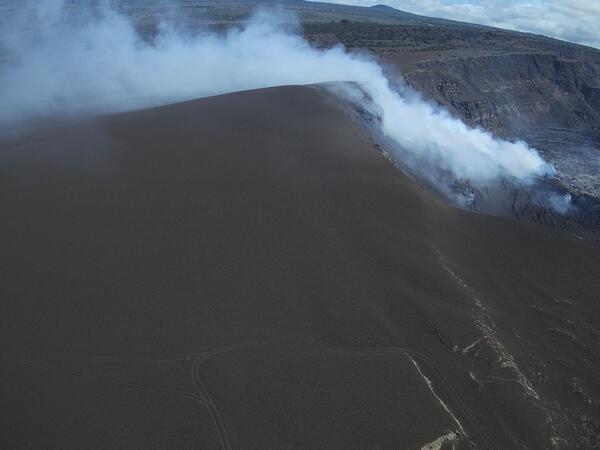
This oblique aerial view of the tephra cone from the ongoing Kīlauea summit eruption was captured during a USGS Hawaiian Volcano Observatory UAS (uncrewed aircraft systems) flight on July 25, 2025. The aircraft was flying about 120 m (400 ft) above ground level, with the image captured looking to the northeast.
This oblique aerial view of the tephra cone from the ongoing Kīlauea summit eruption was captured during a USGS Hawaiian Volcano Observatory UAS (uncrewed aircraft systems) flight on July 25, 2025. The aircraft was flying about 120 m (400 ft) above ground level, with the image captured looking to the northeast.
July 15, 2025 — Kīlauea summit kinematic GPS survey
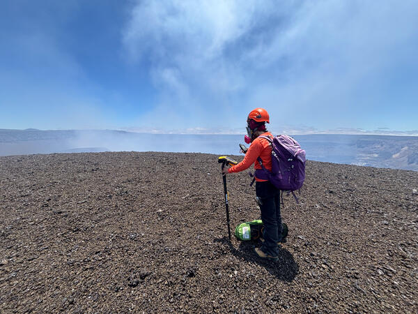
July 15, 2025 — Kīlauea summit kinematic GPS surveyFollowing episode 28 of lava fountaining during the ongoing Kīlauea summit eruption, USGS scientists conducted a kinematic GPS survey to measure changes in the newly formed tephra hill along the caldera rim. This work was carried out with permission from Hawai‘i Volcanoes National Park.
July 15, 2025 — Kīlauea summit kinematic GPS survey
July 15, 2025 — Kīlauea summit kinematic GPS surveyFollowing episode 28 of lava fountaining during the ongoing Kīlauea summit eruption, USGS scientists conducted a kinematic GPS survey to measure changes in the newly formed tephra hill along the caldera rim. This work was carried out with permission from Hawai‘i Volcanoes National Park.
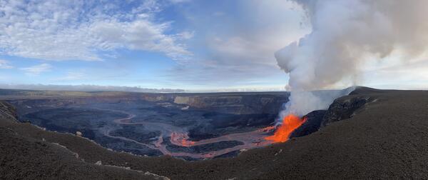
July 20, 2025 — Panoramic image showing episode 29 of Halema‘uma‘u eruption within Kaluapele
July 20, 2025 — Panoramic image showing episode 29 of Halema‘uma‘u eruption within KaluapeleThis panoramic image, taken at 5:39 p.m. H.S.T. on July 20, 2025, shows episode 29 of the ongoing eruption in Halema‘uma‘u crater, within Kaluapele (the summit caldera of Kīlauea volcano).
July 20, 2025 — Panoramic image showing episode 29 of Halema‘uma‘u eruption within Kaluapele
July 20, 2025 — Panoramic image showing episode 29 of Halema‘uma‘u eruption within KaluapeleThis panoramic image, taken at 5:39 p.m. H.S.T. on July 20, 2025, shows episode 29 of the ongoing eruption in Halema‘uma‘u crater, within Kaluapele (the summit caldera of Kīlauea volcano).
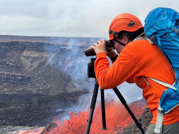
July 20, 2025 — Monitoring Kīlauea summit eruption episode 29
July 20, 2025 — Monitoring Kīlauea summit eruption episode 29During episode 29 of lava fountaining from the ongoing Kīlauea summit eruption, a USGS scientist uses a laser rangefinder from the caldera rim to measure the width and distance of lava channels—data that helps estimate the flow’s velocity. USGS staff visit this hazardous area with permission from Hawai‘i Volcanoes National Park.
July 20, 2025 — Monitoring Kīlauea summit eruption episode 29
July 20, 2025 — Monitoring Kīlauea summit eruption episode 29During episode 29 of lava fountaining from the ongoing Kīlauea summit eruption, a USGS scientist uses a laser rangefinder from the caldera rim to measure the width and distance of lava channels—data that helps estimate the flow’s velocity. USGS staff visit this hazardous area with permission from Hawai‘i Volcanoes National Park.
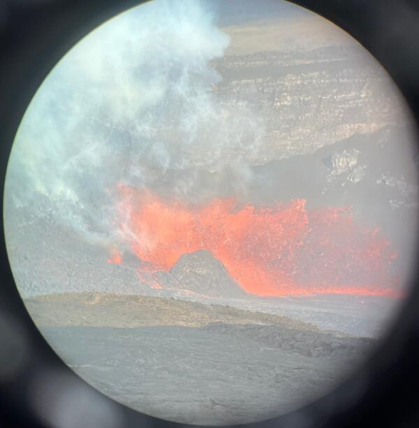
July 20, 2025 — Telephoto view of episode 29 at Kīlauea's summit
July 20, 2025 — Telephoto view of episode 29 at Kīlauea's summitThis view of episode 29 lava fountains within Halema‘uma‘u crater at the summit of Kīlauea was captured through the lens of a laser rangefinder device that USGS Hawaiian Volcano Observatory scientists were using to measure eruptive features. This photo was taken at 7:10 a.m. H.S.T. on July 20, 2025, nearly 2 hours after the start of episode 29.
July 20, 2025 — Telephoto view of episode 29 at Kīlauea's summit
July 20, 2025 — Telephoto view of episode 29 at Kīlauea's summitThis view of episode 29 lava fountains within Halema‘uma‘u crater at the summit of Kīlauea was captured through the lens of a laser rangefinder device that USGS Hawaiian Volcano Observatory scientists were using to measure eruptive features. This photo was taken at 7:10 a.m. H.S.T. on July 20, 2025, nearly 2 hours after the start of episode 29.
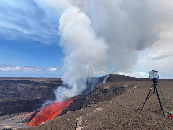
July 20, 2025 — FTIR during Kīlauea summit eruption episode 29
July 20, 2025 — FTIR during Kīlauea summit eruption episode 29During episode 29 of lava fountaining at the ongoing Kīlauea summit eruption, USGS scientists approached the caldera rim—with permission from Hawai‘i Volcanoes National Park—to measure volcanic gas emissions. The lava fountain seen here, on the morning of July 20, reached approximately 100 feet (30 meters) high.
July 20, 2025 — FTIR during Kīlauea summit eruption episode 29
July 20, 2025 — FTIR during Kīlauea summit eruption episode 29During episode 29 of lava fountaining at the ongoing Kīlauea summit eruption, USGS scientists approached the caldera rim—with permission from Hawai‘i Volcanoes National Park—to measure volcanic gas emissions. The lava fountain seen here, on the morning of July 20, reached approximately 100 feet (30 meters) high.
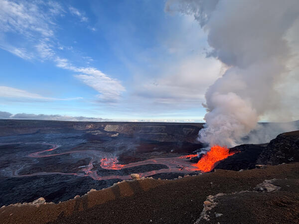
July 20, 2025 — Episode 29 at Kīlauea
Lava fountaining from episode 29 of the ongoing Halemaʻumaʻu eruption began around 5:15 a.m. HST on July 20. The eruption produced large lava flows from the north vent, which traveled approximately 1.5 miles (2.5 kilometers) across the caldera floor. USGS photo by M. Benage.
Lava fountaining from episode 29 of the ongoing Halemaʻumaʻu eruption began around 5:15 a.m. HST on July 20. The eruption produced large lava flows from the north vent, which traveled approximately 1.5 miles (2.5 kilometers) across the caldera floor. USGS photo by M. Benage.
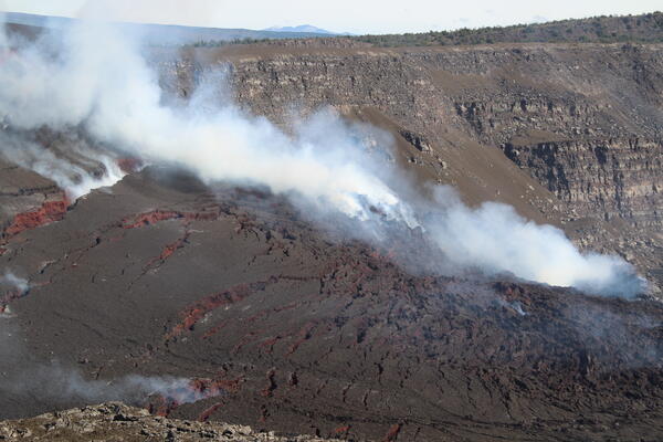
July 17, 2025 — Cone growth around Halema‘uma‘u eruptive vents within Kaluapele
July 17, 2025 — Cone growth around Halema‘uma‘u eruptive vents within KaluapeleSignificant cracks have appeared in the cone around the eruptive vents in Halemaʻumaʻu, as this feature has slumped downwards following episode 28. The south vent, which did not erupt during episode 28, was completely covered but the north vent remains visibly degassing. Mauna Kea is on the horizon in the background of the image. USGS photo by K. Mulliken.
July 17, 2025 — Cone growth around Halema‘uma‘u eruptive vents within Kaluapele
July 17, 2025 — Cone growth around Halema‘uma‘u eruptive vents within KaluapeleSignificant cracks have appeared in the cone around the eruptive vents in Halemaʻumaʻu, as this feature has slumped downwards following episode 28. The south vent, which did not erupt during episode 28, was completely covered but the north vent remains visibly degassing. Mauna Kea is on the horizon in the background of the image. USGS photo by K. Mulliken.
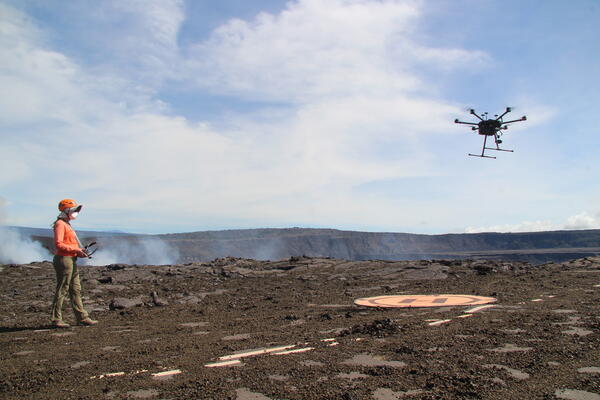
July 17, 2025 — UAS pilot lands UAS after flight over Halema‘uma‘u
July 17, 2025 — UAS pilot lands UAS after flight over Halema‘uma‘uA USGS Hawaiian Volcano Observatory pilot guides a UAS (uncrewed aircraft systems) to the landing pad after an observational flight over the eruptive vents in Halemaʻumaʻu.
July 17, 2025 — UAS pilot lands UAS after flight over Halema‘uma‘u
July 17, 2025 — UAS pilot lands UAS after flight over Halema‘uma‘uA USGS Hawaiian Volcano Observatory pilot guides a UAS (uncrewed aircraft systems) to the landing pad after an observational flight over the eruptive vents in Halemaʻumaʻu.
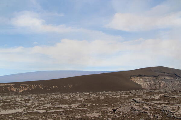
July 17, 2025 — Tephra hill southwest of Halema‘uma‘u eruption, Mauna Loa in background
July 17, 2025 — Tephra hill southwest of Halema‘uma‘u eruption, Mauna Loa in backgroundThe tephra mound on the crater rim southwest of the active vents in Halemaʻumaʻu is nearly 100 feet (30 m) tall after 28 episodes of lava fountaining since December 23, 2024. The profile of the tephra mound nearly mirrors that of Mauna Loa, outlined behind it. USGS photo by K. Mulliken.
July 17, 2025 — Tephra hill southwest of Halema‘uma‘u eruption, Mauna Loa in background
July 17, 2025 — Tephra hill southwest of Halema‘uma‘u eruption, Mauna Loa in backgroundThe tephra mound on the crater rim southwest of the active vents in Halemaʻumaʻu is nearly 100 feet (30 m) tall after 28 episodes of lava fountaining since December 23, 2024. The profile of the tephra mound nearly mirrors that of Mauna Loa, outlined behind it. USGS photo by K. Mulliken.
July 17, 2025 — UAS view into north vent
This near-vertical view into the north vent within Halema‘uma‘u crater was captured during a USGS Hawaiian Volcano Observatory UAS (uncrewed aircraft systems) flight on July 17, 2025. The aircraft was about 150 m (500 ft) above the vent, with north oriented to the upper left in this view. No incandescence or lava was visible within the vent.
This near-vertical view into the north vent within Halema‘uma‘u crater was captured during a USGS Hawaiian Volcano Observatory UAS (uncrewed aircraft systems) flight on July 17, 2025. The aircraft was about 150 m (500 ft) above the vent, with north oriented to the upper left in this view. No incandescence or lava was visible within the vent.