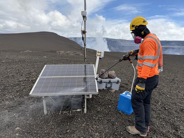
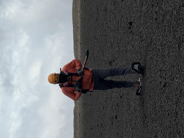
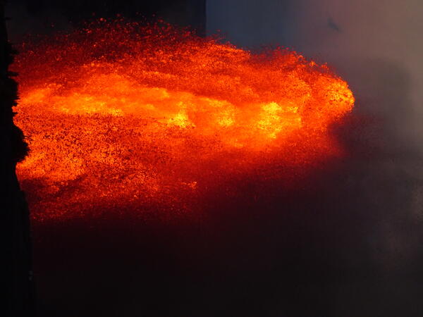
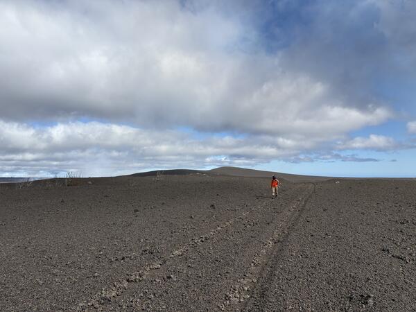
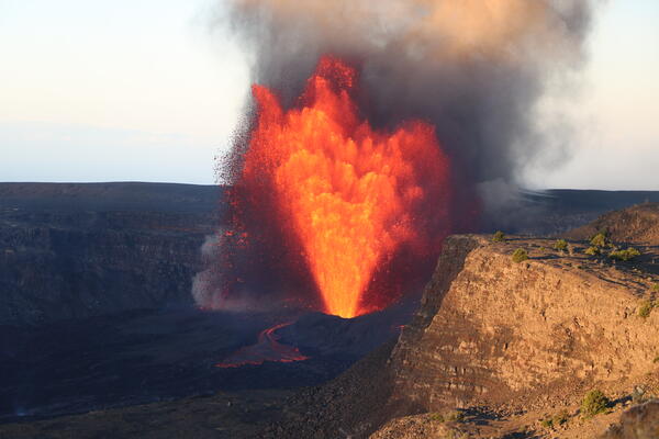
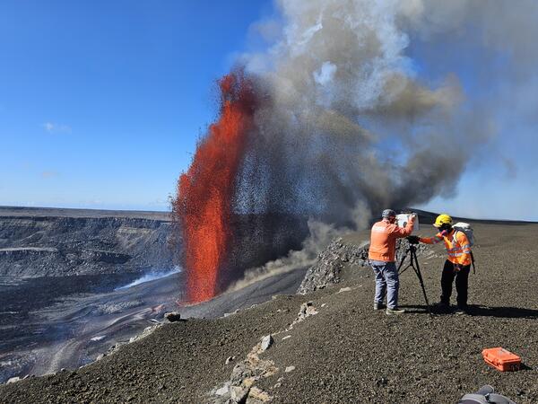
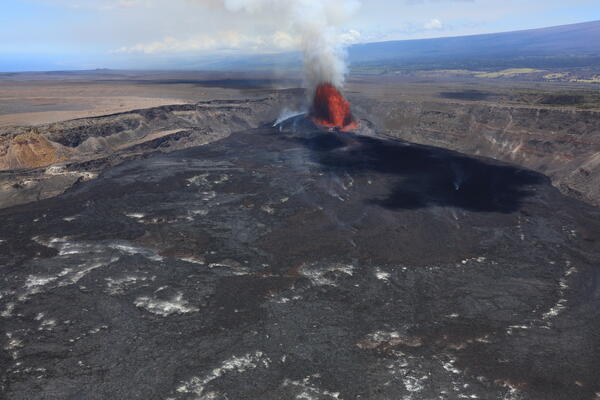
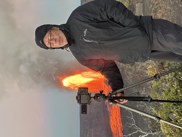
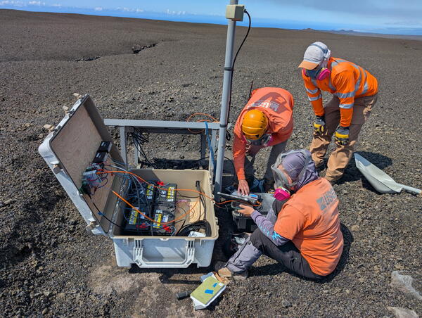
U.S. flag

An official website of the United States government

Images

Hawaiian Volcano Observatory images of eruptive activity, field work, and more.

Filter Total Items: 3867
Color photograph of caldera with eruption within it
April 1, 2025 — Kīlauea summit eruption overflight

USGS Hawaiian Volcano Observatory geologists captured this aerial view of Kīlauea summit on April 1, 2025, during a helicopter overflight about 3 hours after high fountaining started during episode 16 of the ongoing eruption. USGS photo by N. Deligne.

USGS Hawaiian Volcano Observatory geologists captured this aerial view of Kīlauea summit on April 1, 2025, during a helicopter overflight about 3 hours after high fountaining started during episode 16 of the ongoing eruption. USGS photo by N. Deligne.

Color photograph of eruption and volcanologist
April 1, 2025 — View lava fountains above crater rim during episode 16 at Kīlauea's summit

On April 1, lava fountains from Kīlauea's ongoing summit eruption prevented geologists from accessing the rim of Halemaʻumaʻu crater within the closed portion of Hawaiʻi Volcanoes National Park. Instead, they hung back along the closed portion of Crater Rim Drive to collect samples of tephra that was intermittently blown in their direction.

On April 1, lava fountains from Kīlauea's ongoing summit eruption prevented geologists from accessing the rim of Halemaʻumaʻu crater within the closed portion of Hawaiʻi Volcanoes National Park. Instead, they hung back along the closed portion of Crater Rim Drive to collect samples of tephra that was intermittently blown in their direction.

Color photograph of volcanic plume
April 1, 2025 — View of the lava fountain during episode 16 at Kīlauea's summit

Episode 16 lava fountains were visible from Highway 11 in Kaʻū on April 1. In this view, the top of the lava fountain is just visible above Halemaʻumaʻu crater rim, and Uēkahuna (the highest part of the caldera rim) is visible to the left. USGS photo by K. Mulliken. 

Episode 16 lava fountains were visible from Highway 11 in Kaʻū on April 1. In this view, the top of the lava fountain is just visible above Halemaʻumaʻu crater rim, and Uēkahuna (the highest part of the caldera rim) is visible to the left. USGS photo by K. Mulliken. 

Color photograph of road with tephra on the side
April 1, 2025 — Episode 16 of Kīlauea's summit eruption deposits tephra on Highway 11

Episode 16 lava fountains deposited tephra and Pele's Hair on Highway 11 in Kaʻū on April 1. In this photo, taken around 3:30 p.m. HST, the tephra and Pele's Hair is visible along the centerline and on the shoulder of the highway. USGS photo by K. Mulliken. 

Episode 16 lava fountains deposited tephra and Pele's Hair on Highway 11 in Kaʻū on April 1. In this photo, taken around 3:30 p.m. HST, the tephra and Pele's Hair is visible along the centerline and on the shoulder of the highway. USGS photo by K. Mulliken. 

Color photograph of a lava fountain
April 1, 2025 — Telephoto view of episode 16 at Kīlauea's summit

Late in the evening on April 1, USGS Hawaiian Volcano Observatory geologists watched the ongoing Kīlauea summit eruption from Kūpinaʻi Pali (Waldron Ledge). This view of the active eruptive vents was captured through the lens of a laser rangefinder device the geologists were using to measure lava fountain heights. USGS photo by M. Zoeller. 

Late in the evening on April 1, USGS Hawaiian Volcano Observatory geologists watched the ongoing Kīlauea summit eruption from Kūpinaʻi Pali (Waldron Ledge). This view of the active eruptive vents was captured through the lens of a laser rangefinder device the geologists were using to measure lava fountain heights. USGS photo by M. Zoeller. 

Color photograph of lava fountain
April 1, 2025 — Episode 15 lava fountains at Kīlauea's summit

On April 1, a USGS Hawaiian Volcano Observatory geologist captured this zoomed-in photo of the upper portion of the active lava fountain during Kīlauea's ongoing summit eruption.

On April 1, a USGS Hawaiian Volcano Observatory geologist captured this zoomed-in photo of the upper portion of the active lava fountain during Kīlauea's ongoing summit eruption.

Color photograph of eruption plume
April 1, 2025 — View of episode 16 eruption plume at Kīlauea's summit

The episode 16 eruption plume was transported north-northwest on April 1, over Highway 11 in Kaʻū. USGS Hawaiian Volcano Observatory volcanic gas specialists traversed under the plume on the highway in order to get a sulfur dioxide emission rate for episode 16.

The episode 16 eruption plume was transported north-northwest on April 1, over Highway 11 in Kaʻū. USGS Hawaiian Volcano Observatory volcanic gas specialists traversed under the plume on the highway in order to get a sulfur dioxide emission rate for episode 16.

Color photograph of rocks on road
April 1, 2025 — Episode 16 tephra and Pele's Hair on Highway 11

Wind conditions during episode 16 of the Kīlauea summit eruption resulted in material from the lava fountains being deposited on Highway 11 on April 1. This photo shows the amount of material, including tephra and Pele's Hair, that had accumulated by 3:30 p.m. HST. A Hawaii County Civil Defense Agency message at 12:49 p.m.

Wind conditions during episode 16 of the Kīlauea summit eruption resulted in material from the lava fountains being deposited on Highway 11 on April 1. This photo shows the amount of material, including tephra and Pele's Hair, that had accumulated by 3:30 p.m. HST. A Hawaii County Civil Defense Agency message at 12:49 p.m.

Color photograph of lava fountain
April 1, 2025 — Kīlauea summit eruption episode 16 aerial view

Kīlauea summit eruption episode 16 lava fountain and its lava flow on April 1, 2025. The lava fountain was reaching heights of more than 650 ft (200 m) at times and feeding a lava flow that as of noon on April 1 reached about 2,300 ft (700 m) from its vent. The lava fountain was also depositing a tephra blanket to the northwest that was reaching Highway 11.

Kīlauea summit eruption episode 16 lava fountain and its lava flow on April 1, 2025. The lava fountain was reaching heights of more than 650 ft (200 m) at times and feeding a lava flow that as of noon on April 1 reached about 2,300 ft (700 m) from its vent. The lava fountain was also depositing a tephra blanket to the northwest that was reaching Highway 11.

Color photograph of eruption and growing deposit
April 1, 2025 — Lava fountain and tephra blanket at the summit of Kīlauea

Kīlauea summit lava fountain from the west end of Halemaʻumaʻu and the tephra blanket it has produced through its 16 episodes. In some places, the tephra blanket reaches more than 5 ft (1.5 m) thick. Most of the tephra from episode 16 lava fountain on April 1, 2025, was blowing to the northwest, with some clasts reaching Highway 11. USGS photo by D. Downs.

Kīlauea summit lava fountain from the west end of Halemaʻumaʻu and the tephra blanket it has produced through its 16 episodes. In some places, the tephra blanket reaches more than 5 ft (1.5 m) thick. Most of the tephra from episode 16 lava fountain on April 1, 2025, was blowing to the northwest, with some clasts reaching Highway 11. USGS photo by D. Downs.

Color photograph of lava fountain
April 1, 2025 — Episode 16 lava fountain from Halemaʻumaʻu, Kīlauea

USGS Hawaiian Volcano Observatory geologist captured this aerial view during a monitoring helicopter overflight of episode 16 at around noon on April 1, 2025.  The lava fountain feeds a lava flow from the western end of Halemaʻumaʻu.

USGS Hawaiian Volcano Observatory geologist captured this aerial view during a monitoring helicopter overflight of episode 16 at around noon on April 1, 2025.  The lava fountain feeds a lava flow from the western end of Halemaʻumaʻu.

Color photograph of lava fountain
April 1, 2025 — Kīlauea lava fountain and flow in Halemaʻumaʻu

Helicopter overflight view of episode 16 lava fountain and its lava flow on the crater floor of Kaluapele at around noon on April 1, 2025. The lava flow at this time had traveled 2,300 ft (700 m) from the fountain along the floor of Halemaʻumaʻu. USGS photo by D. Downs.


Helicopter overflight view of episode 16 lava fountain and its lava flow on the crater floor of Kaluapele at around noon on April 1, 2025. The lava flow at this time had traveled 2,300 ft (700 m) from the fountain along the floor of Halemaʻumaʻu. USGS photo by D. Downs.


Color photograph of erupting lava fountains
March 29, 2025 — Kīlauea episode 15 lava fountaining

Lava fountaining during episode 15 of the summit eruption at Kīlauea volcano. USGS webcam image.

Color photograph of inactive volcanic vent
March 27, 2025 — View of north vent a day after episode 15 at Kīlauea's summit

View of north vent from the northwest, nearly 12 hours after the end of episode 15 of the eruption at Kīlauea's summit. Tephra covers the slopes of north vent, and the area to the north, giving the appearance of a surface covered in brown sand.

View of north vent from the northwest, nearly 12 hours after the end of episode 15 of the eruption at Kīlauea's summit. Tephra covers the slopes of north vent, and the area to the north, giving the appearance of a surface covered in brown sand.

Color photograph of defoliated tree
March 27, 2025 — Tree partially buried by tephra from episode 15 of Kīlauea's summit eruption

Photo of a tree partially buried and damaged by the tephra deposit produced by the high fountaining on March 26, 2025, during episode 15 of Kīlauea's summit eruption in Halema‘uma‘u. Prior to episode 15, this was a healthy tree growing in a gully, about 130 meters (about 140 yards) west of the rim of Halema‘uma‘u.

Photo of a tree partially buried and damaged by the tephra deposit produced by the high fountaining on March 26, 2025, during episode 15 of Kīlauea's summit eruption in Halema‘uma‘u. Prior to episode 15, this was a healthy tree growing in a gully, about 130 meters (about 140 yards) west of the rim of Halema‘uma‘u.

Color maps showing eruption site temperature
March 27, 2025 — Thermal maps of activity at Kīlauea summit

This compilation shows thermal maps made shortly after three different lava fountaining episodes at the summit of Kīlauea. Each fountaining episode produced short-lived lava flows in the western portion of the crater floor, near the vent, which were inactive and solidified by the time of the thermal maps.

This compilation shows thermal maps made shortly after three different lava fountaining episodes at the summit of Kīlauea. Each fountaining episode produced short-lived lava flows in the western portion of the crater floor, near the vent, which were inactive and solidified by the time of the thermal maps.

Color photograph of lava fountain
March 26, 2025 — Kīlauea Episode 15 Lava Fountains

USGS Hawaiian Volcano Observatory geologists observed the fountain activity and monitored changing fountain heights during episode 15 of the Halema‘uma‘u eruption. This photo was taken at 1:00 p.m. HST on March 26 during the high fountain stage of the episode. Photo direction is looking south. Fountain heights reached up to about 750 feet (230 meters) at this time.

USGS Hawaiian Volcano Observatory geologists observed the fountain activity and monitored changing fountain heights during episode 15 of the Halema‘uma‘u eruption. This photo was taken at 1:00 p.m. HST on March 26 during the high fountain stage of the episode. Photo direction is looking south. Fountain heights reached up to about 750 feet (230 meters) at this time.

Color photograph of lava fountains
March 26, 2025 — Kīlauea Episode 15 Lava Fountains

Lava fountain activity during episode 15 of the Halema‘uma‘u eruption at the summit of Kīlauea. Fountain heights reached up to about 1,000 feet (305 meters) during episode 15. Vigorous lava fountaining feeds lava flows on the floor of Halemaʻumaʻu crater.  USGS photo by C. Gansecki. 


Lava fountain activity during episode 15 of the Halema‘uma‘u eruption at the summit of Kīlauea. Fountain heights reached up to about 1,000 feet (305 meters) during episode 15. Vigorous lava fountaining feeds lava flows on the floor of Halemaʻumaʻu crater.  USGS photo by C. Gansecki. 


Color photograph of scientist monitoring eruption
March 26, 2025 — Observing Episode 15 at the summit of Kīlauea

A USGS Hawaiian Volcano Observatory geologist takes measurements of the fountain heights during episode 15 of the Kīlauea summit eruption in Halema‘uma‘u. This photo, looking south, was taken at around 10:41 a.m. HST on March 26, during the beginning stages of the high fountains. Fountains from the south vent reached over the top of the crater wall at this time.

A USGS Hawaiian Volcano Observatory geologist takes measurements of the fountain heights during episode 15 of the Kīlauea summit eruption in Halema‘uma‘u. This photo, looking south, was taken at around 10:41 a.m. HST on March 26, during the beginning stages of the high fountains. Fountains from the south vent reached over the top of the crater wall at this time.

Color photograph of volcanic vents erupting
March 26, 2025 — Episode 15 of Halema'uma'u eruption, Kīlauea

During the cyclic low fountain to drainback phase of episode 15, both the north and south vents were active. This low-level activity began March 25 around 9:30 a.m. HST and continued for just over 24 hours before the fountaining phase began. USGS photo by H Winslow.

During the cyclic low fountain to drainback phase of episode 15, both the north and south vents were active. This low-level activity began March 25 around 9:30 a.m. HST and continued for just over 24 hours before the fountaining phase began. USGS photo by H Winslow.

Color photograph of lava fountains
March 26, 2025 — Kīlauea Episode 15 Lava Fountains

Lava fountain activity during episode 15 of the Halema‘uma‘u eruption at the summit of Kīlauea. Fountain heights reached up to about 1,000 feet (305 meters) during episode 15. USGS photo by C. Gansecki. 

Lava fountain activity during episode 15 of the Halema‘uma‘u eruption at the summit of Kīlauea. Fountain heights reached up to about 1,000 feet (305 meters) during episode 15. USGS photo by C. Gansecki. 

Was this page helpful?