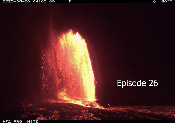
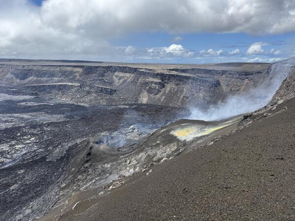
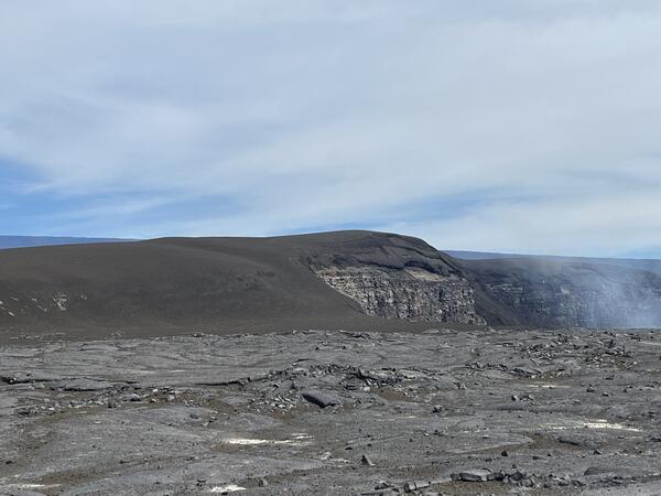
U.S. flag

An official website of the United States government

Images

Hawaiian Volcano Observatory images of eruptive activity, field work, and more.

Filter Total Items: 3867
Color photograph of eruptive vent
March 19, 2025 — Low dome fountain in north vent

A closer view of the low dome fountain at the northern eruptive vent within Halemaʻumaʻu crater at the summit of Kīlauea on March 19, 2025. USGS photo by M. Patrick.

A closer view of the low dome fountain at the northern eruptive vent within Halemaʻumaʻu crater at the summit of Kīlauea on March 19, 2025. USGS photo by M. Patrick.

Color photograph of eruptive vent
March 19, 2025 — Gas jetting in north vent

At the summit of Kīlauea on March 19, 2025, the onset of draining at the northern eruptive vent within Halemaʻumaʻu crater included intense gas jetting, spraying small droplets of lava vertically. USGS photo by M. Patrick.

At the summit of Kīlauea on March 19, 2025, the onset of draining at the northern eruptive vent within Halemaʻumaʻu crater included intense gas jetting, spraying small droplets of lava vertically. USGS photo by M. Patrick.

Color photograph of lava within a volcanic vent
March 19, 2025 — Gas-piston cycle at Kīlauea summit

In the top panel, lava rises in the north vent in Halemaʻumaʻu prior to Episode 14 on March 19, 2025. Note that only a faint, hazy gas plume is visible near the right edge of the lava surface.

In the top panel, lava rises in the north vent in Halemaʻumaʻu prior to Episode 14 on March 19, 2025. Note that only a faint, hazy gas plume is visible near the right edge of the lava surface.

Color photograph of eruptive vent and lava flow
March 19, 2025 — Lava flow from south vent

Early on March 19, the southern eruptive vent within Halemaʻumaʻu crater at the summit of Kīlauea was the primary host of low-level eruptive activity. This photo, captured from the southern crater rim, shows minor spatter at the vent and a small lava flow proceeding onto the crater floor. USGS photo by M. Zoeller.

Early on March 19, the southern eruptive vent within Halemaʻumaʻu crater at the summit of Kīlauea was the primary host of low-level eruptive activity. This photo, captured from the southern crater rim, shows minor spatter at the vent and a small lava flow proceeding onto the crater floor. USGS photo by M. Zoeller.

Color photograph of eruptive vent
March 19, 2025 — Spattering in north vent

At the summit of Kīlauea on March 19, 2025, cycles of filling and draining at the northern eruptive vent within Halemaʻumaʻu crater included periods of more intense spattering in the lava pond. USGS photo by M. Patrick.

At the summit of Kīlauea on March 19, 2025, cycles of filling and draining at the northern eruptive vent within Halemaʻumaʻu crater included periods of more intense spattering in the lava pond. USGS photo by M. Patrick.

Color map showing eruption extent
March 18, 2025—Kīlauea summit eruption reference map

This reference map depicts the Kīlauea summit eruption within Halema‘uma‘u crater that began on December 23, 2024. As of this posting on March 18, the eruption has had thirteen episodes, with the most recent occurring on March 11.

This reference map depicts the Kīlauea summit eruption within Halema‘uma‘u crater that began on December 23, 2024. As of this posting on March 18, the eruption has had thirteen episodes, with the most recent occurring on March 11.

A new darker brown tephra deposit blankets the terrain downwind of the Kīlauea summit eruption
Aerial overview of Kīlauea summit tephra deposit

On Friday, March 14, Hawaiian Volcano Observatory geologists on a morning helicopter overflight captured aerial photography to map tephra deposits downwind (southwest) of vents from the Kīlauea summit eruption that began December 23, 2024.

On Friday, March 14, Hawaiian Volcano Observatory geologists on a morning helicopter overflight captured aerial photography to map tephra deposits downwind (southwest) of vents from the Kīlauea summit eruption that began December 23, 2024.

A view of Halema‘uma‘u and the downdropped block
March 14, 2025 —Aerial view of Halema‘uma‘u crater

A closer view of Halema‘uma‘u and the downdropped block, within the deepest portion of Kīlauea's summit caldera. Lava flows have crept eastward (towards bottom left in photo) as the crater floor rises with recent infilling. USGS photo taken on March 14, 2025, by M. Patrick.

A closer view of Halema‘uma‘u and the downdropped block, within the deepest portion of Kīlauea's summit caldera. Lava flows have crept eastward (towards bottom left in photo) as the crater floor rises with recent infilling. USGS photo taken on March 14, 2025, by M. Patrick.

A white plume of volcanic gas rises from a volcanic vent in a crater
March 14, 2025 — Kīlauea summit eruption overflight with Mauna Loa in the background

A low-angle aerial view of the vents where episodic fountaining has been occurring since the start of the ongoing Kīlauea summit eruption on December 23, 2024. A white plume of volcanic gas rises from the north vent (center right) and south vent (center left) cones in the southwest corner of Halema‘uma‘u crater, as viewed during a monitoring overflight.

A low-angle aerial view of the vents where episodic fountaining has been occurring since the start of the ongoing Kīlauea summit eruption on December 23, 2024. A white plume of volcanic gas rises from the north vent (center right) and south vent (center left) cones in the southwest corner of Halema‘uma‘u crater, as viewed during a monitoring overflight.

A tephra deposit blankets a paved roadway downwind of Kīlauea's summit
Low-level aerial view of Kīlauea summit tephra deposit

This low-level aerial view of the tephra deposit from Kīlauea's ongoing summit eruption was captured during a Hawaiian Volcano Observatory helicopter overflight on Friday, March 14.

This low-level aerial view of the tephra deposit from Kīlauea's ongoing summit eruption was captured during a Hawaiian Volcano Observatory helicopter overflight on Friday, March 14.

A wide aerial view of the summit caldera (Kaluapele) at Kīlauea volcano
March 14, 2025 —Aerial view of Kīlauea summit

A wide aerial view of the summit caldera (Kaluapele) at Kīlauea volcano, showing recent lava flows (center of photo) filling the deepest portion of Halema‘uma‘u crater. The white outgassing plume from the recently active vents is carried to the southwest in the tradewinds.

A wide aerial view of the summit caldera (Kaluapele) at Kīlauea volcano, showing recent lava flows (center of photo) filling the deepest portion of Halema‘uma‘u crater. The white outgassing plume from the recently active vents is carried to the southwest in the tradewinds.

Silver fissures and lava flows taken during an overflight of Kīlauea upper Southwest Rift Zone
March 14, 2025—View of Kīlauea December 1974 fissures and lava flows

An aerial view of the December 31, 1974 fissures and lava flows taken during an overflight of Kīlauea summit and upper Southwest Rift Zone on March 14, 2025. The 1974 eruption lasted 6 hours and occurred in Kīlauea's upper Southwest Rift Zone.

An aerial view of the December 31, 1974 fissures and lava flows taken during an overflight of Kīlauea summit and upper Southwest Rift Zone on March 14, 2025. The 1974 eruption lasted 6 hours and occurred in Kīlauea's upper Southwest Rift Zone.

Wide aerial view of Kīlauea summit caldera
March 14, 2025—Kīlauea summit eruption overflight

Hawaiian Volcano Observatory geologists captured this aerial view of Kīlauea summit on March 14, 2025, during a helicopter overflight. Three days after the end of episode 13 of the ongoing eruption, the north and south cones are degassing in the southwest corner of Halema‘uma‘u.

Hawaiian Volcano Observatory geologists captured this aerial view of Kīlauea summit on March 14, 2025, during a helicopter overflight. Three days after the end of episode 13 of the ongoing eruption, the north and south cones are degassing in the southwest corner of Halema‘uma‘u.

Close up aerial view of the north vent cone degassing in the southwest corner of Halema‘uma‘u
March 14, 2025 — Kīlauea eruption remains on pause during summit overflight

On the morning of March 14, USGS Hawaiian Volcano Observatory scientists conducted an overflight of Kīlauea summit to capture thermal and surficial imagery of the ongoing (paused) eruption. Three days after the end of episode 13, this telephoto aerial view shows the north cone degassing in the southwest corner of Halema‘uma‘u.

On the morning of March 14, USGS Hawaiian Volcano Observatory scientists conducted an overflight of Kīlauea summit to capture thermal and surficial imagery of the ongoing (paused) eruption. Three days after the end of episode 13, this telephoto aerial view shows the north cone degassing in the southwest corner of Halema‘uma‘u.

Brown volcanic cones partially buried by recent solidified black lava flows
March 14, 2025 —Aerial view of September 2023 Kīlauea cones

On the morning of March 14, USGS Hawaiian Volcano Observatory scientists conducted a monitoring overflight of Kīlauea. This aerial view shows cones formed during the September 2023 eruption, surrounded and partially buried by lava erupted within the past few weeks during the ongoing (and currently paused) eruption within Halema‘uma‘u. USGS photo by N. Deligne.

On the morning of March 14, USGS Hawaiian Volcano Observatory scientists conducted a monitoring overflight of Kīlauea. This aerial view shows cones formed during the September 2023 eruption, surrounded and partially buried by lava erupted within the past few weeks during the ongoing (and currently paused) eruption within Halema‘uma‘u. USGS photo by N. Deligne.

A shovel is stuck into a thick deposit of gray/brown volcanic tephra
Crater Rim Drive tephra blanket

The section of Crater Rim Drive downwind of the recent fountaining, and in an area closed to the public due to volcanic hazards, has been covered by numerous layers of tephra in the past several months. The tire tracks are centered over the Crater Rim Drive roadway, where USGS scientists access critical volcano monitoring sites.

The section of Crater Rim Drive downwind of the recent fountaining, and in an area closed to the public due to volcanic hazards, has been covered by numerous layers of tephra in the past several months. The tire tracks are centered over the Crater Rim Drive roadway, where USGS scientists access critical volcano monitoring sites.

A scientist works on servicing volcano monitoring equipment with steaming volcanic vents in background
HVO geologist services webcam day after episode 13 at Kīlauea

On March 12, a USGS Hawaiian Volcano Observatory geologist on the southwest rim of Kaluapele (Kīlauea summit caldera) serviced the S2cam webcam. A plume of water vapor and volcanic gas rises from the two vents of the ongoing eruption within Halema‘uma‘u crater, one day after the 13th episode of the eruption. USGS photo by N. Deligne.

On March 12, a USGS Hawaiian Volcano Observatory geologist on the southwest rim of Kaluapele (Kīlauea summit caldera) serviced the S2cam webcam. A plume of water vapor and volcanic gas rises from the two vents of the ongoing eruption within Halema‘uma‘u crater, one day after the 13th episode of the eruption. USGS photo by N. Deligne.

A scientist walks on a blanket of gray tephra with tire tracks over the buried pavement
Kīlauea summit tephra blanket from episodic fountaining

An HVO geologist returns from a tephra collection bucket at the summit of Kīlauea, carrying a new sample. The outgassing plume from the vents is carried over the roadway, now covered by over 50 cm (20 inches) of tephra in places. All samples are collected in coordination with, and after receiving permission from, Hawai‘i Volcanoes National Park. USGS photo by M.

An HVO geologist returns from a tephra collection bucket at the summit of Kīlauea, carrying a new sample. The outgassing plume from the vents is carried over the roadway, now covered by over 50 cm (20 inches) of tephra in places. All samples are collected in coordination with, and after receiving permission from, Hawai‘i Volcanoes National Park. USGS photo by M.

Molten lava fountain erupting from a vent of dark cooled lava
Episode 13 fountaining at Kīlauea summit

On the morning of March 11, the north vent was producing lava fountains about 50 meters (160 feet) high, with fountaining emerging from a small, sloshing pond held within the walls of the north vent cone. The pond can be seen in the lower left portion of the photo, as well as the lava spillway which exits through a notch in the cone that is obscured in this view.

On the morning of March 11, the north vent was producing lava fountains about 50 meters (160 feet) high, with fountaining emerging from a small, sloshing pond held within the walls of the north vent cone. The pond can be seen in the lower left portion of the photo, as well as the lava spillway which exits through a notch in the cone that is obscured in this view.

A white plume of volcanic gas exits from two vents on the crater floor
Degassing cones a day after the end of episode 13 at Halema‘uma‘u, Kīlauea

The north and south cones on the western edge of Halema‘uma‘u continued degassing on March 12, a day after the end of episode 13 of the ongoing eruption at Kīlauea's summit. Most of the gas consists of water vapor (the primary volcanic gas), with sulfur dioxide (SO2) and other gases. Sulfur dioxide emissions are causing vog downwind of the summit area.

The north and south cones on the western edge of Halema‘uma‘u continued degassing on March 12, a day after the end of episode 13 of the ongoing eruption at Kīlauea's summit. Most of the gas consists of water vapor (the primary volcanic gas), with sulfur dioxide (SO2) and other gases. Sulfur dioxide emissions are causing vog downwind of the summit area.

Zoomed in view of two inactive lava vents with white volcanic gas plumes being emitted
Kīlauea south vent cone within Halema‘uma‘u

A closeup view of the south cone at the summit of Kīlauea, showing the semi-molten nature of the cone flanks. During fountaining, lava accumulates on the cone's flanks at such a high rate that the material remains hot and semi-molten, despite the appearance of cooled, solid material on the surface.

A closeup view of the south cone at the summit of Kīlauea, showing the semi-molten nature of the cone flanks. During fountaining, lava accumulates on the cone's flanks at such a high rate that the material remains hot and semi-molten, despite the appearance of cooled, solid material on the surface.

Was this page helpful?