
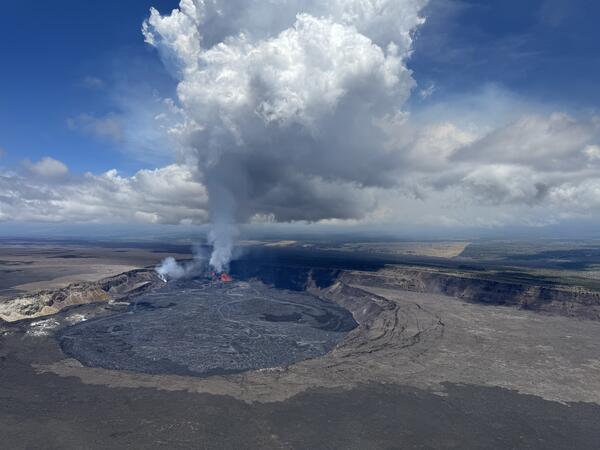
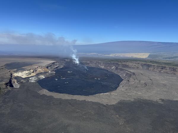
An aerial view of Kīlauea Iki and Pu‘u Pua‘i taken during a USGS Hawaiian Volcano Obsrvatory monitoring overflight of Kīlauea summit on August 8.
Images
Hawaiian Volcano Observatory images of eruptive activity, field work, and more.
Filter Total Items: 4072
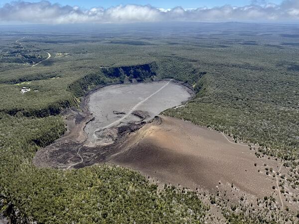
August 8, 2025 — View of Kīlauea Iki
An aerial view of Kīlauea Iki and Pu‘u Pua‘i taken during a USGS Hawaiian Volcano Obsrvatory monitoring overflight of Kīlauea summit on August 8.
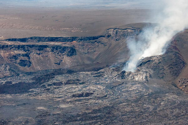
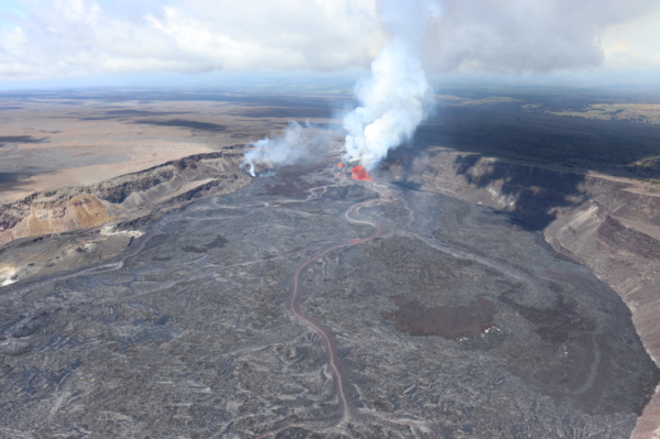
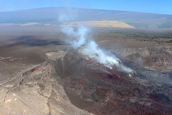
August 8, 2025 — Halema‘uma‘u Crater Post Episode 30
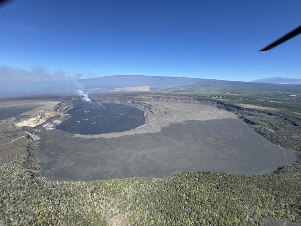
August 8, 2025 — Halema‘uma‘u Crater Post Episode 30An aerial image taken during a USGS Hawaiian Volcano Observatory monitoring overflight, following the end of episode 30 on August 6.
August 8, 2025 — Halema‘uma‘u Crater Post Episode 30
August 8, 2025 — Halema‘uma‘u Crater Post Episode 30An aerial image taken during a USGS Hawaiian Volcano Observatory monitoring overflight, following the end of episode 30 on August 6.
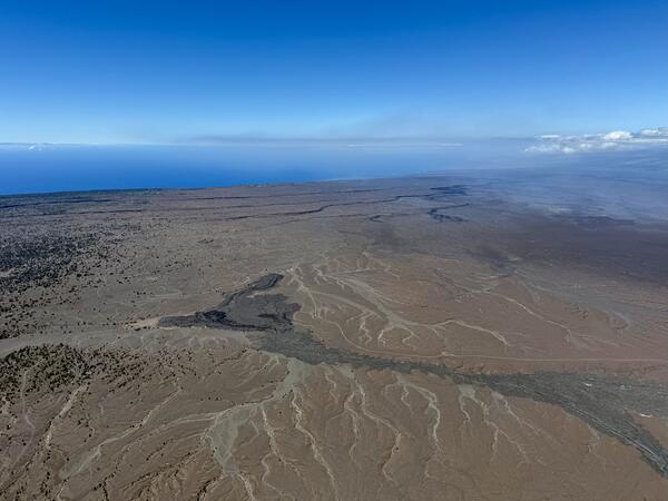
August 8, 2025 — View of Kīlauea South Flank
This aerial image, taken during a Kīlauea summit overflight on August 8, 2025, looks southwest towards the ocean. In the foreground, two small lava flows that were erupted from Kīlauea in 1982 and 1971 are visible. The darker one on the left is from September 1971, while the shiny grey one on the right is from September 1982.
This aerial image, taken during a Kīlauea summit overflight on August 8, 2025, looks southwest towards the ocean. In the foreground, two small lava flows that were erupted from Kīlauea in 1982 and 1971 are visible. The darker one on the left is from September 1971, while the shiny grey one on the right is from September 1982.

August 6, 2025 — Episode 30 at night
Early in the morning on August 6, Hawaiian Volcano Observatory geologists visited the western rim of Halemaʻumaʻu crater to observe Kīlauea summit eruption episode 30. Lava fountains were reaching about 70 meters (230 feet) above the north vent at the time. USGS photo by N. Deligne.
Early in the morning on August 6, Hawaiian Volcano Observatory geologists visited the western rim of Halemaʻumaʻu crater to observe Kīlauea summit eruption episode 30. Lava fountains were reaching about 70 meters (230 feet) above the north vent at the time. USGS photo by N. Deligne.
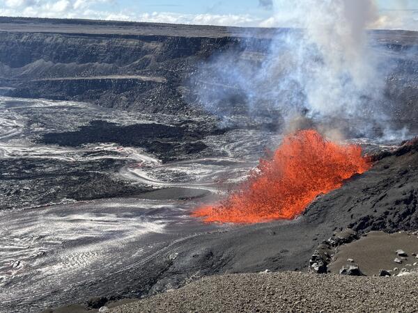
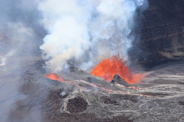
Episode 30 lava fountaining at Kīlauea summit
A view of the episode 30 lava fountaining in the north vent, taken from the west rim of Kaluapele, Kīlauea's summit caldera. The fountaining was sending out several lava channels across the crater floor, with lava flows reaching the eastern portion of Halema‘uma‘u crater. USGS photo taken by M. Patrick on August 6, 2025.
A view of the episode 30 lava fountaining in the north vent, taken from the west rim of Kaluapele, Kīlauea's summit caldera. The fountaining was sending out several lava channels across the crater floor, with lava flows reaching the eastern portion of Halema‘uma‘u crater. USGS photo taken by M. Patrick on August 6, 2025.
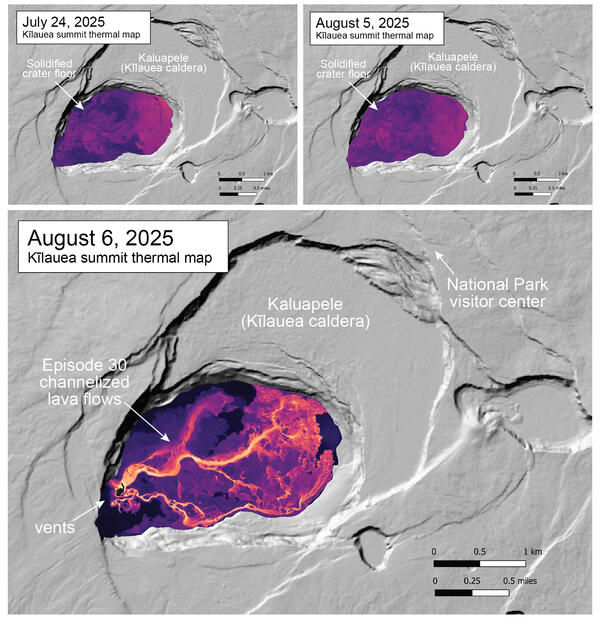
August 6, 2025 — Thermal map of Kīlauea episode 30 lava flows
August 6, 2025 — Thermal map of Kīlauea episode 30 lava flowsThe August 6 thermal map shows the widespread channelized lava flows covering the crater floor, originating from the episode 30 lava fountaining in the western end of Halema‘uma‘u crater at the summit of Kīlauea. Most of the lava originated from the vigorous fountaining at the north vent, with the weak fountaining at the south vent contributing a smaller volume.
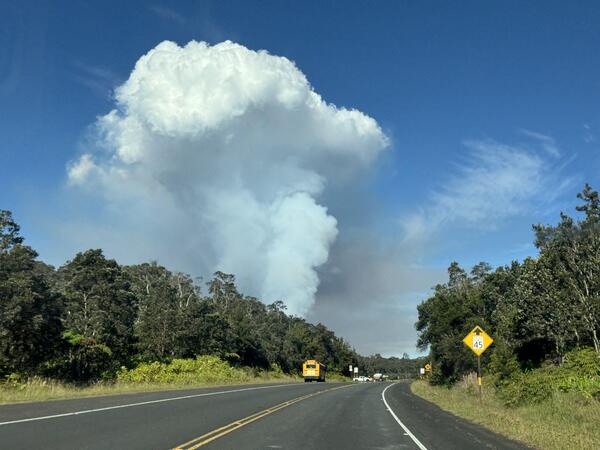
August 6, 2025 — Kīlauea episode 30 plume
Slack winds allowed the outgassing plume from the episode 30 lava fountaining to rise vertically above Kīlauea summit caldera, making it easily visible from Highway 11. USGS photo by M. Patrick.
Slack winds allowed the outgassing plume from the episode 30 lava fountaining to rise vertically above Kīlauea summit caldera, making it easily visible from Highway 11. USGS photo by M. Patrick.

August 6, 2025 — sinkhole at the summit of Kīlauea
August 6, 2025 — sinkhole at the summit of KīlaueaOn the south rim of Halemaʻumaʻu, new sink holes in ash and tephra that blankets the ground in this area were observed following episode 30 of the Kīlauea summit eruption on August 6. The sinkholes formed due to underlying cracks that opened as a result of the new fissure in the south wall of the caldera. USGS photo by M. Patrick.
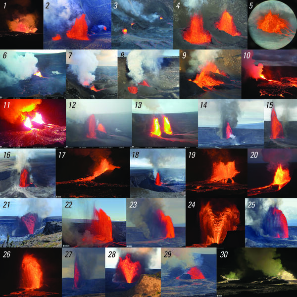
August 7, 2025 — Photo compilation of episodes 1–30 of the ongoing eruption at the summit of Kīlauea
August 7, 2025 — Photo compilation of episodes 1–30 of the ongoing eruption at the summit of KīlaueaPhoto compilation of episodes 1–30 of the ongoing eruption at the summit of Kīlauea, including webcam imagery and photos taken by USGS Hawaiian Volcano Observatory scientists on the ground and during helicopter overflights. In all photos except for episode 7, the south vent is on the left and the north vent is on the right.
Episode 30 lava fountaining at Kīlauea summit
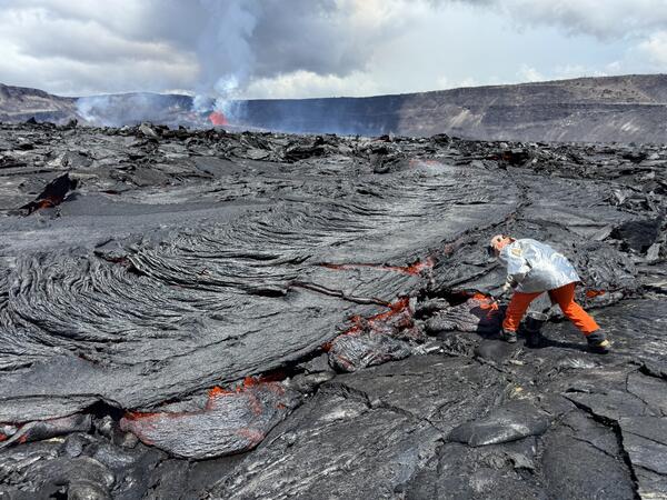
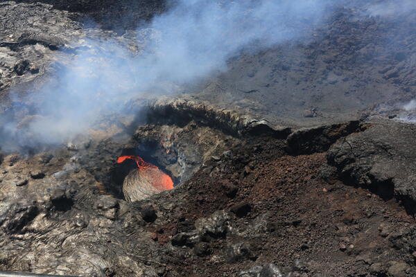
A USGS geologist collects a molten sample of the episode 30 lava flows, quenching the sample in a bucket of water. The chemistry of these lava samples is analyzed to better understand the source and storage of magma driving Hawaiian eruptions. USGS photo by M. Patrick taken on August 6, 2025.
A USGS geologist collects a molten sample of the episode 30 lava flows, quenching the sample in a bucket of water. The chemistry of these lava samples is analyzed to better understand the source and storage of magma driving Hawaiian eruptions. USGS photo by M. Patrick taken on August 6, 2025.
Episode 30 lava fountaining at Kīlauea summit
A helicopter overflight on the morning of August 6, during episode 30 of the ongoing Halema‘uma‘u eruption, provided aerial views of the lava fountaining and numerous channelized lava flows covering the crater floor. USGS photo by M. Patrick.
A helicopter overflight on the morning of August 6, during episode 30 of the ongoing Halema‘uma‘u eruption, provided aerial views of the lava fountaining and numerous channelized lava flows covering the crater floor. USGS photo by M. Patrick.
Episode 30 lava fountaining at Kīlauea summit
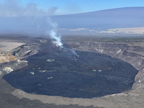
An aerial photograph of the ongoing Kīlauea summit eruption within Halema‘uma‘u crater taken during an overflight on August 6, 2025. This photo, looking to the west, shows episode 30 lava fountains and lava flows covering the crater floor.
An aerial photograph of the ongoing Kīlauea summit eruption within Halema‘uma‘u crater taken during an overflight on August 6, 2025. This photo, looking to the west, shows episode 30 lava fountains and lava flows covering the crater floor.
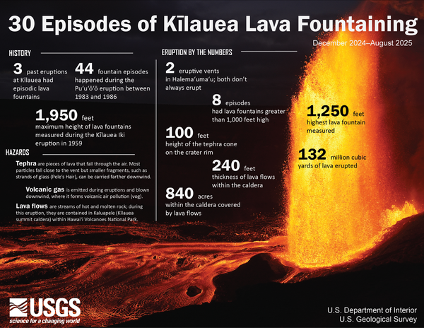
30 episodes of lava fountaining at Kīlauea
Kīlauea has had 30 episodes of lava fountaining in Halemaʻumaʻu crater, within the summit caldera, since December 23, 2024. This infographic summarizes the past 30 episodes of activity, providing context for this episodic eruption and summarizing the relevant hazards. USGS graphic.
Kīlauea has had 30 episodes of lava fountaining in Halemaʻumaʻu crater, within the summit caldera, since December 23, 2024. This infographic summarizes the past 30 episodes of activity, providing context for this episodic eruption and summarizing the relevant hazards. USGS graphic.

August 6, 2025 — Episode 30 at sunrise
Hawaiian Volcano Observatory geologists watched a spectacular sunrise over Kīlauea summit eruption episode 30 on the morning of August 6. Lava flows had covered about 60% of the Halemaʻumaʻu crater floor by that time. USGS photo by N. Deligne.
Hawaiian Volcano Observatory geologists watched a spectacular sunrise over Kīlauea summit eruption episode 30 on the morning of August 6. Lava flows had covered about 60% of the Halemaʻumaʻu crater floor by that time. USGS photo by N. Deligne.
Episode 30 lava fountaining at Kīlauea summit
A telephoto aerial view of the episode 30 lava fountaining at Kīlauea summit, taken during a morning helicopter overflight. The dominant fountain was in the north vent, while a smaller fountain was active in the south vent. Channelized streams of lava, fed by the fountains in the north and south vents, flow to the eastern portion of the crater floor.
A telephoto aerial view of the episode 30 lava fountaining at Kīlauea summit, taken during a morning helicopter overflight. The dominant fountain was in the north vent, while a smaller fountain was active in the south vent. Channelized streams of lava, fed by the fountains in the north and south vents, flow to the eastern portion of the crater floor.
August 5, 2025 — Overview of Kaluapele
The Hawaiian Volcano Observatory's helicopter overflight on August 5 provided aerial views of Kaluapele (Kīlauea caldera) and the outgassing plume from the eruptive vents in Halema‘uma‘u crater. Mauna Loa can be seen in the background. USGS photo by M. Patrick.
The Hawaiian Volcano Observatory's helicopter overflight on August 5 provided aerial views of Kaluapele (Kīlauea caldera) and the outgassing plume from the eruptive vents in Halema‘uma‘u crater. Mauna Loa can be seen in the background. USGS photo by M. Patrick.
August 5, 2025 — Wide-angle view of Kaluapele
This wide-angle view of Kaluapele (Kīlauea caldera) was captured during the Hawaiian Volcano Observatory's helicopter overflight on August 5, showing the eastern caldera floor (near) along with more recent lava flows (far, darker circular zone) covering the floor of Halema‘uma‘u crater.
This wide-angle view of Kaluapele (Kīlauea caldera) was captured during the Hawaiian Volcano Observatory's helicopter overflight on August 5, showing the eastern caldera floor (near) along with more recent lava flows (far, darker circular zone) covering the floor of Halema‘uma‘u crater.
August 5, 2025 — Eruptive activity in the north vent
August 5, 2025 — Eruptive activity in the north ventDuring a monitoring overflight on August 5 at approximately 9:45 a.m. HST, Hawaiian Volcano Observatory geologists documented a lava pond within the north vent of the ongoing Kīlauea summit eruption. The pond was flowing into a subterranean lava tube contained within the east side of the vent cone, toward the floor of Halema‘uma‘u crater. USGS photo K.
August 5, 2025 — Overview of Halema‘uma‘u
This closer view of Halema‘uma‘u crater at the summit of Kīlauea was captured during the Hawaiian Volcano Observatory's helicopter overflight on August 5. The circular black zone consists of recent lava flows that have been filling the crater in recent months, and the outgassing plume from the eruptive vents is carried southwest by the trade winds. USGS photo by M.
This closer view of Halema‘uma‘u crater at the summit of Kīlauea was captured during the Hawaiian Volcano Observatory's helicopter overflight on August 5. The circular black zone consists of recent lava flows that have been filling the crater in recent months, and the outgassing plume from the eruptive vents is carried southwest by the trade winds. USGS photo by M.
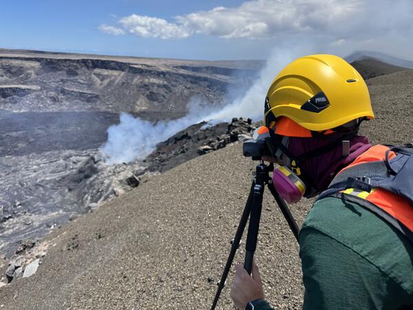
August 5, 2025 — Laser rangefinder measurements of north vent
August 5, 2025 — Laser rangefinder measurements of north ventOn August 5, USGS geologists used a laser rangefinder to measure the elevation of the small lava pond spotted today within the Halema‘uma‘u north vent at the summit of Kīlauea. USGS photo by M. Patrick.
August 5, 2025 — Overview of Halemaʻumaʻu eruptive vents
August 5, 2025 — Overview of Halemaʻumaʻu eruptive ventsThis aerial view of the complex tephra cone built in recent months around the Halemaʻumaʻu eruptive vents was captured on August 5. The cone has been built against the western wall of Kaluapele (Kīlauea caldera), with tephra also forming a hill atop the caldera rim.