



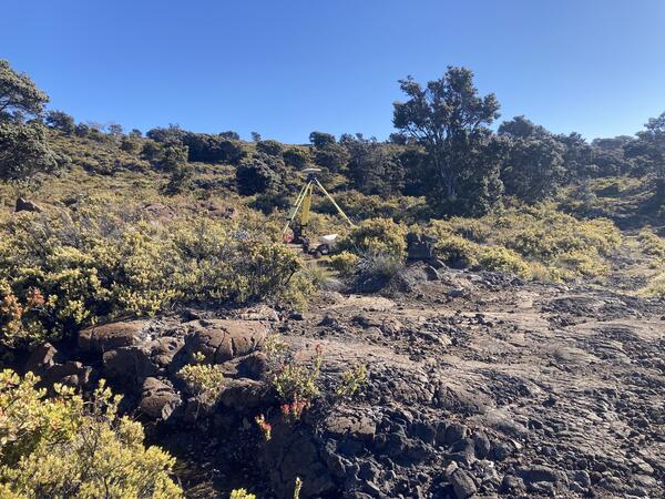
Campaign, also known as 'survey', GPS data augment the permanent, continuously recording GPS instruments in HVO's monitoring network. In this photo, a tripod mounted with a GPS antenna is temporarily installed over a benchmark the rim of Moku‘āweoweo, the caldera at the summit of Mauna Loa.
Images
Hawaiian Volcano Observatory images of eruptive activity, field work, and more.
Filter Total Items: 4163

2025 Annual Campaign GPS measurements in progress
Campaign, also known as 'survey', GPS data augment the permanent, continuously recording GPS instruments in HVO's monitoring network. In this photo, a tripod mounted with a GPS antenna is temporarily installed over a benchmark the rim of Moku‘āweoweo, the caldera at the summit of Mauna Loa.

2025 Annual Campaign GPS measurements in progress
USGS Hawaiian Volcano Observatory staff are conducting the annual Mauna Loa GPS campaign. During the survey, GPS instruments are deployed at established benchmarks so that their recorded positions can be compared with those from previous years to discern small changes in ground deformation associated with volcanic activity.
USGS Hawaiian Volcano Observatory staff are conducting the annual Mauna Loa GPS campaign. During the survey, GPS instruments are deployed at established benchmarks so that their recorded positions can be compared with those from previous years to discern small changes in ground deformation associated with volcanic activity.
2025 Annual Campaign GPS measurements in progress
Another GPS survey benchmark being occupied on Mauna Loa's lower southwest flank. USGS photo by A. Ellis.
Another GPS survey benchmark being occupied on Mauna Loa's lower southwest flank. USGS photo by A. Ellis.

2025 Annual Campaign GPS measurements in progress
A GPS benchmark on west side of Mauna Loa's summit being measured with campaign GPS equipment during the annual Mauna Loa GPS campaign survey. Hualālai is visible in the background. USGS photo by A. Ellis.
A GPS benchmark on west side of Mauna Loa's summit being measured with campaign GPS equipment during the annual Mauna Loa GPS campaign survey. Hualālai is visible in the background. USGS photo by A. Ellis.

Changes to Kīlauea summit landscape over the past six months
Changes to Kīlauea summit landscape over the past six monthsA cropped comparison of two USGS Hawaiian Volcano Observatory webcam images showing changes to the landscape of Kīlauea summit region over the past six months. Twenty-five episodes of lava fountaining within Halemaʻumaʻu have contributed to a growing deposit of tephra material in the closed area of Hawaiʻi Volcanoes National Park, southwest of the vents.
Changes to Kīlauea summit landscape over the past six months
Changes to Kīlauea summit landscape over the past six monthsA cropped comparison of two USGS Hawaiian Volcano Observatory webcam images showing changes to the landscape of Kīlauea summit region over the past six months. Twenty-five episodes of lava fountaining within Halemaʻumaʻu have contributed to a growing deposit of tephra material in the closed area of Hawaiʻi Volcanoes National Park, southwest of the vents.

June 11, 2025 — Episode 25 lava fountaining at Kīlauea summit
June 11, 2025 — Episode 25 lava fountaining at Kīlauea summitThe ongoing Halema‘uma‘u Kīlauea summit eruption continued today with episode 25, which began at 11:57 am HST. Fountains from the north vent reached approximately 1000 feet (305 m) while south vent fountains were continuously less than 165 feet (50 m).
June 11, 2025 — Episode 25 lava fountaining at Kīlauea summit
June 11, 2025 — Episode 25 lava fountaining at Kīlauea summitThe ongoing Halema‘uma‘u Kīlauea summit eruption continued today with episode 25, which began at 11:57 am HST. Fountains from the north vent reached approximately 1000 feet (305 m) while south vent fountains were continuously less than 165 feet (50 m).

June 11, 2025 — Episode 25 lava fountaining at Kīlauea summit
June 11, 2025 — Episode 25 lava fountaining at Kīlauea summitWednesday June 11 is Kamehameha Day in Hawaii, and many island residents took advantage of the state holiday to visit Kīlauea and watch episode 25 of the ongoing summit eruption in Halemaʻumaʻu. The back lawn of Volcano House has been popular observation post, with expansive views of Kaluapele (the summit caldera) and the lava fountain in the distance.
June 11, 2025 — Episode 25 lava fountaining at Kīlauea summit
June 11, 2025 — Episode 25 lava fountaining at Kīlauea summitWednesday June 11 is Kamehameha Day in Hawaii, and many island residents took advantage of the state holiday to visit Kīlauea and watch episode 25 of the ongoing summit eruption in Halemaʻumaʻu. The back lawn of Volcano House has been popular observation post, with expansive views of Kaluapele (the summit caldera) and the lava fountain in the distance.

June 11, 2025 — Episode 25 lava fountaining at Kīlauea summit
June 11, 2025 — Episode 25 lava fountaining at Kīlauea summitOn Wednesday June 11, the twenty-fifth episode of the ongoing Kīlauea summit eruption occurred. twenty-fifth episode from Volcano House within HAWAII Volcanoes National Park. In this photo, captured around 1:45 p.m.
June 11, 2025 — Episode 25 lava fountaining at Kīlauea summit
June 11, 2025 — Episode 25 lava fountaining at Kīlauea summitOn Wednesday June 11, the twenty-fifth episode of the ongoing Kīlauea summit eruption occurred. twenty-fifth episode from Volcano House within HAWAII Volcanoes National Park. In this photo, captured around 1:45 p.m.

June 11, 2025 — Episode 25 lava fountaining at Kīlauea summit
June 11, 2025 — Episode 25 lava fountaining at Kīlauea summitLate in the afternoon on Wednesday, June 11, USGS Hawaiian Volcano Observatory geologists visited the western rim of Halemaʻumaʻu crater for a closer look at the active Kīlauea summit eruptive vents. Even several hours into eruptive episode 25, lava fountains were still reaching higher than the crater rim, over 500 ft (150 m) tall. USGS photo by M.
June 11, 2025 — Episode 25 lava fountaining at Kīlauea summit
June 11, 2025 — Episode 25 lava fountaining at Kīlauea summitLate in the afternoon on Wednesday, June 11, USGS Hawaiian Volcano Observatory geologists visited the western rim of Halemaʻumaʻu crater for a closer look at the active Kīlauea summit eruptive vents. Even several hours into eruptive episode 25, lava fountains were still reaching higher than the crater rim, over 500 ft (150 m) tall. USGS photo by M.

June 11, 2025 — Photo compilation of episodes 1–25 of the ongoing eruption at the summit of Kīlauea
June 11, 2025 — Photo compilation of episodes 1–25 of the ongoing eruption at the summit of KīlaueaPhoto compilation of episodes 1–25 of the ongoing eruption at the summit of Kīlauea, including webcam imagery and photos taken by USGS Hawaiian Volcano Observatory scientists on the ground and during helicopter overflights. In all photos except for episode 7, the south vent is on the left and the north vent is on the right.
June 11, 2025 — Photo compilation of episodes 1–25 of the ongoing eruption at the summit of Kīlauea
June 11, 2025 — Photo compilation of episodes 1–25 of the ongoing eruption at the summit of KīlaueaPhoto compilation of episodes 1–25 of the ongoing eruption at the summit of Kīlauea, including webcam imagery and photos taken by USGS Hawaiian Volcano Observatory scientists on the ground and during helicopter overflights. In all photos except for episode 7, the south vent is on the left and the north vent is on the right.

June 7, 2025 — Kīlauea lava flow and tephra fall map following episode 24
June 7, 2025 — Kīlauea lava flow and tephra fall map following episode 24This map shows lava flow and tephra accumulation at Kīlauea volcano associated with episode 24 of the ongoing eruption in Halemaʻumaʻu that started on December 23, 2024. The image covers the timespan from May 30–June 7, 2025, using data recorded by the Italian Space Agency's (ASI) COSMO-SkyMed Second Generation satellite constellation.
June 7, 2025 — Kīlauea lava flow and tephra fall map following episode 24
June 7, 2025 — Kīlauea lava flow and tephra fall map following episode 24This map shows lava flow and tephra accumulation at Kīlauea volcano associated with episode 24 of the ongoing eruption in Halemaʻumaʻu that started on December 23, 2024. The image covers the timespan from May 30–June 7, 2025, using data recorded by the Italian Space Agency's (ASI) COSMO-SkyMed Second Generation satellite constellation.
June 6, 2025—Kīlauea summit eruption reference map
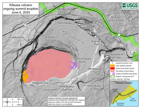
June 6, 2025—Kīlauea summit eruption reference mapThis reference map depicts the Kīlauea summit eruption within Halema‘uma‘u crater that began on December 23, 2024. As of this posting on June 6, the eruption continues episodically.
June 6, 2025—Kīlauea summit eruption reference map
June 6, 2025—Kīlauea summit eruption reference mapThis reference map depicts the Kīlauea summit eruption within Halema‘uma‘u crater that began on December 23, 2024. As of this posting on June 6, the eruption continues episodically.

June 6, 2025 — Effects of episode 24 lava fountaining at Kīlauea summit
June 6, 2025 — Effects of episode 24 lava fountaining at Kīlauea summitThe webcam monitoring the Southwest Rift Zone of Kīlauea is downwind of the vents active during the ongoing eruption at the summit, and it was in the fallout zone of tephra coming from the episode 24 lava fountaining. This image shows a barrage of clasts falling around the camera, with the camera view knocked out of alignment.
June 6, 2025 — Effects of episode 24 lava fountaining at Kīlauea summit
June 6, 2025 — Effects of episode 24 lava fountaining at Kīlauea summitThe webcam monitoring the Southwest Rift Zone of Kīlauea is downwind of the vents active during the ongoing eruption at the summit, and it was in the fallout zone of tephra coming from the episode 24 lava fountaining. This image shows a barrage of clasts falling around the camera, with the camera view knocked out of alignment.

June 5, 2025 — episode 24 lava fountaining at Kīlauea summit
June 5, 2025 — episode 24 lava fountaining at Kīlauea summitLava fountaining during episode 24 of the ongoing summit eruption of Kīlauea.
June 5, 2025 — episode 24 lava fountaining at Kīlauea summit
June 5, 2025 — episode 24 lava fountaining at Kīlauea summitLava fountaining during episode 24 of the ongoing summit eruption of Kīlauea.
June 4, 2025 — Episode 24 of lava fountaining at Kīlauea summit
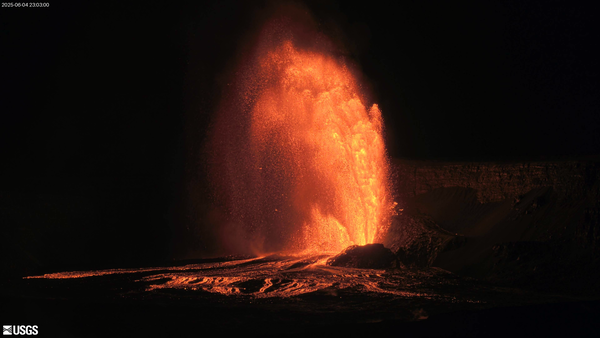
June 4, 2025 — Episode 24 of lava fountaining at Kīlauea summitFrom USGS Hawaiian Volcano Observatory livestreaming V2cam, a plume-like fountain erupted from the north vent during episode 24 on June 4–5, 2025, creating an elegant arc. With a maximum fountain height of 364 meters (1194 feet), this was the highest fountain observed up until that point. USGS photo.
June 4, 2025 — Episode 24 of lava fountaining at Kīlauea summit
June 4, 2025 — Episode 24 of lava fountaining at Kīlauea summitFrom USGS Hawaiian Volcano Observatory livestreaming V2cam, a plume-like fountain erupted from the north vent during episode 24 on June 4–5, 2025, creating an elegant arc. With a maximum fountain height of 364 meters (1194 feet), this was the highest fountain observed up until that point. USGS photo.
May 30, 2025 — Kīlauea lava flow and tephra fall map following episode 23
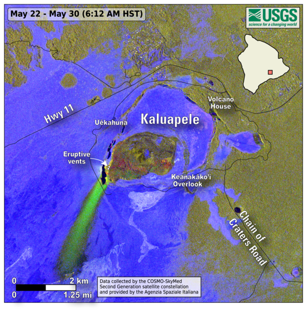
May 30, 2025 — Kīlauea lava flow and tephra fall map following episode 23This map shows lava flow and tephra accumulation at Kīlauea volcano associated with episode 23 of the ongoing eruption in Halemaʻumaʻu that started on December 23, 2024. The image covers the timespan from May 22–30, 2025, using data recorded by the Italian Space Agency's (ASI) COSMO-SkyMed Second Generation satellite constellation.
May 30, 2025 — Kīlauea lava flow and tephra fall map following episode 23
May 30, 2025 — Kīlauea lava flow and tephra fall map following episode 23This map shows lava flow and tephra accumulation at Kīlauea volcano associated with episode 23 of the ongoing eruption in Halemaʻumaʻu that started on December 23, 2024. The image covers the timespan from May 22–30, 2025, using data recorded by the Italian Space Agency's (ASI) COSMO-SkyMed Second Generation satellite constellation.

May 29, 2025 — Kīlauea thermal maps following episode 21 and 23
May 29, 2025 — Kīlauea thermal maps following episode 21 and 23This compilation shows thermal maps of Kīlauea summit collected on May 14 and 28, 2025. These maps followed episodes 21 and 23 of the ongoing Kīlauea summit eruption, respectively, and both show inactive but warm lava flows produced by the preceding lava fountaining episodes.
May 29, 2025 — Kīlauea thermal maps following episode 21 and 23
May 29, 2025 — Kīlauea thermal maps following episode 21 and 23This compilation shows thermal maps of Kīlauea summit collected on May 14 and 28, 2025. These maps followed episodes 21 and 23 of the ongoing Kīlauea summit eruption, respectively, and both show inactive but warm lava flows produced by the preceding lava fountaining episodes.

May 29, 2025 — Kīlauea summit fieldwork after episode 23
May 29, 2025 — Kīlauea summit fieldwork after episode 23A thick deposit of tephra from the high fountaining of episode 23—along with accumulation from previous episodes—of the ongoing Kīlauea summit eruption, blankets the southwestern rim of Halema‘uma‘u crater. The deposit, within the closed area of Hawai‘i Volcanoes National Park, underscores the hazardous nature of this area.
May 29, 2025 — Kīlauea summit fieldwork after episode 23
May 29, 2025 — Kīlauea summit fieldwork after episode 23A thick deposit of tephra from the high fountaining of episode 23—along with accumulation from previous episodes—of the ongoing Kīlauea summit eruption, blankets the southwestern rim of Halema‘uma‘u crater. The deposit, within the closed area of Hawai‘i Volcanoes National Park, underscores the hazardous nature of this area.

May 29, 2025 — Kīlauea summit fieldwork after episode 23
May 29, 2025 — Kīlauea summit fieldwork after episode 23During the pause after episode 23 of the ongoing Kīlauea summit eruption, a USGS Hawaiian Volcano Observatory scientist collects data on the tephra deposits. Buckets are used to collect tephra, and emptied between episodes, to ensure that samples from each episode are isolated to track geochemical changes and determine the amount of tephra that fell at each site.
May 29, 2025 — Kīlauea summit fieldwork after episode 23
May 29, 2025 — Kīlauea summit fieldwork after episode 23During the pause after episode 23 of the ongoing Kīlauea summit eruption, a USGS Hawaiian Volcano Observatory scientist collects data on the tephra deposits. Buckets are used to collect tephra, and emptied between episodes, to ensure that samples from each episode are isolated to track geochemical changes and determine the amount of tephra that fell at each site.

May 29, 2025 — Kīlauea summit fieldwork after episode 23
May 29, 2025 — Kīlauea summit fieldwork after episode 23A USGS Hawaiian Volcano Observatory geologist collects high-precision ground positions using a kinematic GPS instrument that measures its vertical and horizontal position. Once processed, these measurements will help scientists determine the thickness of the tephra deposit downwind of the ongoing Halema‘uma‘u eruption at Kīlauea summit.
May 29, 2025 — Kīlauea summit fieldwork after episode 23
May 29, 2025 — Kīlauea summit fieldwork after episode 23A USGS Hawaiian Volcano Observatory geologist collects high-precision ground positions using a kinematic GPS instrument that measures its vertical and horizontal position. Once processed, these measurements will help scientists determine the thickness of the tephra deposit downwind of the ongoing Halema‘uma‘u eruption at Kīlauea summit.

May 29, 2025 — Kīlauea summit fieldwork after episode 23
May 29, 2025 — Kīlauea summit fieldwork after episode 23A close-up view looking at one of the more vesicular pieces of tephra from a recent fountaining episode at Kīlauea summit. When the gas-rich lava erupting from the vents quickly cools, it solidifies with this light and frothy texture. The bubble walls are so thin that the color of this tephra is more golden brown. USGS photo taken by L.
May 29, 2025 — Kīlauea summit fieldwork after episode 23
May 29, 2025 — Kīlauea summit fieldwork after episode 23A close-up view looking at one of the more vesicular pieces of tephra from a recent fountaining episode at Kīlauea summit. When the gas-rich lava erupting from the vents quickly cools, it solidifies with this light and frothy texture. The bubble walls are so thin that the color of this tephra is more golden brown. USGS photo taken by L.