U.S. flag

An official website of the United States government

Yellowstone Volcano Observatory

Find U.S. Volcano
Current Alerts
Yellowstone
green NORMAL, 2024-09-01 12:33:41 UTC

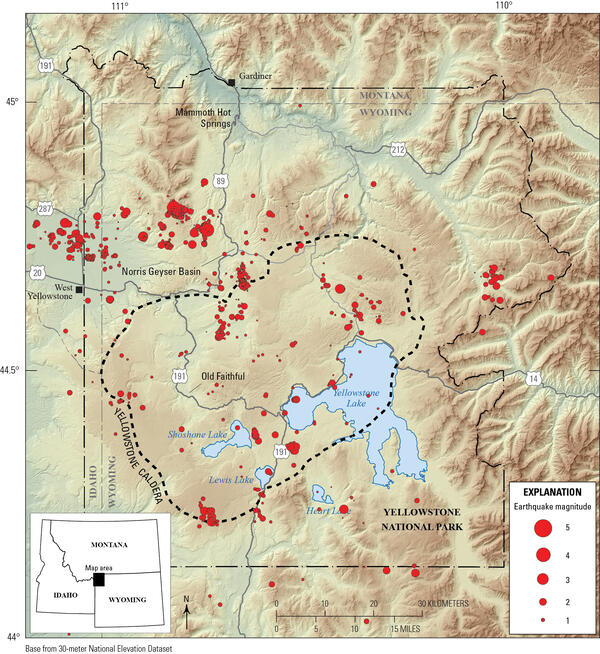
The Yellowstone Volcano Observatory (YVO) is a consortium of nine state and federal agencies who provide timely monitoring and hazard assessment of volcanic, hydrothermal, and earthquake activity in the Yellowstone Plateau region. The USGS arm of YVO is also responsible for monitoring and reporting on volcanic activity in the intermountain west U.S. states.

News

The mountain that roared

The mountain that roared

New study seeks to shed light on earthquake hazards in the Gallatin Range

New study seeks to shed light on earthquake hazards in the Gallatin Range

Quartz crystals record cooling of deposits from super eruptions

Quartz crystals record cooling of deposits from super eruptions

Publications

Volcano crisis response at Yellowstone volcanic complex - after-action report for exercise held at Salt Lake City, Utah, November 15, 2011

A functional tabletop exercise was run on November 14-15, 2011 in Salt Lake City, Utah, to test crisis response capabilities, communication protocols, and decision-making by the staff of the multi-agency Yellowstone Volcano Observatory (YVO) as they reacted to a hypothetical exercise scenario of accelerating volcanic unrest at the Yellowstone caldera. The exercise simulated a rapid build-up of sei
Authors
Thomas C. Pierson, Carolyn L. Driedger, Robert I. Tilling

History of surface displacements at the Yellowstone Caldera, Wyoming, from leveling surveys and InSAR observations, 1923-2008

Modern geodetic studies of the Yellowstone caldera, Wyoming, and its extraordinary tectonic, magmatic, and hydrothermal systems date from an initial leveling survey done throughout Yellowstone National Park in 1923 by the U.S. Coast and Geodetic Survey. A repeat park-wide survey by the U.S. Geological Survey (USGS) and the University of Utah during 1975-77 revealed that the central part of the cal
Authors
Daniel Dzurisin, Charles W. Wicks, Michael P. Poland

Water chemistry and electrical conductivity database for rivers in Yellowstone National Park, Wyoming

Chloride flux has been used to estimate heat flow in volcanic environments since the method was developed in New Zealand by Ellis and Wilson (1955). The method can be applied effectively at Yellowstone, because nearly all of the water discharged from its thermal features enters one of four major rivers (the Madison, Yellowstone, Snake, and Falls Rivers) that drain the park, and thus integration of
Authors
Laura E. Clor, R. Blaine McCleskey, Mark A. Huebner, Jacob B. Lowenstern, Henry P. Heasler, Dan L. Mahony, Tim Maloney, William C. Evans

Multimedia

Is there oil in Yellowstone? Is there oil in Yellowstone? (Yellowstone Monthly Update - September 2024)
Is there oil in Yellowstone? (Yellowstone Monthly Update - September 2024)
A man in a green shirt is building a gauge for rapid deployment. The gauge is a large black box, sitting on a workbench.
USGS response to Tropical Storm Debby in Georgia
Plot of size versus annual probability for hydrothermal explosion craters in Yellowstone National Park
Graph showing explosions recorded at Black Diamond Pool in Biscuit Basin, Yellowstone National Park, during 2006 through 2016
Update Biscuit Basin Biscuit Basin Update; 65th Anniversary — M7.3 Hebgen Lake Quake (Yellowstone Monthly Update - Aug 2024)
Biscuit Basin Update; 65th Anniversary — M7.3 Hebgen Lake Quake (Yellowstone Monthly Update - Aug 2024)
Photomicrograph showing a quartz-hosted embayment from the Mesa Falls Tuff, accompanied by a map showing the location of the tuff in eastern Idaho.
Quartz-hosted embayment from the Mesa Falls Tuff
Photomicrograph showing water distribution in a quartz-hosted embayment, with greater concentrations at the embayment mouth. Includes a plot showing that the temperature in which the water circulated must have been about 500 degrees Celsius.
Water distribution in a quartz-hosted embayment from the Mesa Falls Tuff
Shaded relief location map for the East Gallatin-Reese Creek fault system in northwest Yellowstone National Park
Lidar hillshade maps of fault scarps that offset Pinedale glacial till along the East Gallatin-Reese Creek fault system, Yellowstone National Park
Was this page helpful?