
A USGS storm-tide sensor, deployed in advance of Hurricane Florence's landfall. The sensors are housed in vented steel pipes a few inches wide and about a foot long. They are being installed on bridges, piers, and other structures that have a good chance of surviving the storm.
Images
Explore our planet through photography and imagery, including climate change and water all the way back to the 1800s when the USGS was surveying the country by horse and buggy.
Filter Total Items: 21357

USGS Storm-Tide Sensor for Hurricane Florence
A USGS storm-tide sensor, deployed in advance of Hurricane Florence's landfall. The sensors are housed in vented steel pipes a few inches wide and about a foot long. They are being installed on bridges, piers, and other structures that have a good chance of surviving the storm.

USGS storm-tide sensor installed for Hurricane Florence
USGS storm-tide sensor installed for Hurricane FlorenceThis USGS storm-tide sensor was installed Sept. 9 in Dare County, North Carolina, in preparation for Hurricane Florence. Photo by Steve Harden, USGS.
USGS storm-tide sensor installed for Hurricane Florence
USGS storm-tide sensor installed for Hurricane FlorenceThis USGS storm-tide sensor was installed Sept. 9 in Dare County, North Carolina, in preparation for Hurricane Florence. Photo by Steve Harden, USGS.

Beetle Damage in the Black Hills
Mountain pine beetles are about the size of a grain of rice, so of course we can’t see them from space in satellite images. What is visible is what the beetles can do to a pine forest. The washed-out pink color indicates large areas of standing dead or damaged trees.
Mountain pine beetles are about the size of a grain of rice, so of course we can’t see them from space in satellite images. What is visible is what the beetles can do to a pine forest. The washed-out pink color indicates large areas of standing dead or damaged trees.

Peace at dusk
USGS oceanographer Shawn Harrison stands on the coastal bluff of Barter Island, Alaska at sunset. Shawn and his fellow researchers are studying how the highly erosive bluff changes under the varied conditions experienced by this stretch of coastline.
USGS oceanographer Shawn Harrison stands on the coastal bluff of Barter Island, Alaska at sunset. Shawn and his fellow researchers are studying how the highly erosive bluff changes under the varied conditions experienced by this stretch of coastline.

Geothermal seep that flows into Yellowstone River, LaDuke Hot Springs
Geothermal seep that flows into Yellowstone River, LaDuke Hot SpringsView of one of the geothermal seeps that flows into the Yellowstone River south of LaDuke Hot Spring.
Geothermal seep that flows into Yellowstone River, LaDuke Hot Springs
Geothermal seep that flows into Yellowstone River, LaDuke Hot SpringsView of one of the geothermal seeps that flows into the Yellowstone River south of LaDuke Hot Spring.

Landsat 8 image of the Apostle Islands in Lake Superior
Landsat 8 image of the Apostle Islands in Lake SuperiorCitation: Citation_Information: Originator: U.S.
Landsat 8 image of the Apostle Islands in Lake Superior
Landsat 8 image of the Apostle Islands in Lake SuperiorCitation: Citation_Information: Originator: U.S.

Steel pipe with small temperature sensors.
Left: steel pipe with small temperature sensors placed every few inches. Right: temperature pipe installed in the streambed.
Left: steel pipe with small temperature sensors placed every few inches. Right: temperature pipe installed in the streambed.

UAV flight west side of Yellowstone River next to LaDuke Hot springs
UAV flight west side of Yellowstone River next to LaDuke Hot springsMontana Bureau of Mines and Geology and Montana Tech scientists preparing for a UAV flight on the west side of the Yellowstone River adjacent from LaDuke Hot Springs.

Eagle Creek above Findlay OH - muddy waters and debris
Eagle Creek above Findlay OH - muddy waters and debrisEagle Creek above Findlay OH - muddy waters and debris
Eagle Creek above Findlay OH - muddy waters and debris
Eagle Creek above Findlay OH - muddy waters and debrisEagle Creek above Findlay OH - muddy waters and debris

Eagle Creek above Findlay OH - view looking upstream towards gage
Eagle Creek above Findlay OH - view looking upstream towards gageEagle Creek above Findlay OH - view looking upstream towards gage
Eagle Creek above Findlay OH - view looking upstream towards gage
Eagle Creek above Findlay OH - view looking upstream towards gageEagle Creek above Findlay OH - view looking upstream towards gage

Flushing stomach contents from a live resident Chinook salmon
Flushing stomach contents from a live resident Chinook salmonFlushing stomach contents from a live resident Chinook salmon for an investigation of cannibalism and predation impacts.
Flushing stomach contents from a live resident Chinook salmon
Flushing stomach contents from a live resident Chinook salmonFlushing stomach contents from a live resident Chinook salmon for an investigation of cannibalism and predation impacts.

Kīlauea summit September 6, 2018
Kīlauea summit photo taken on September 6, 2018.
Kīlauea summit photo taken on September 6, 2018.

Retrieving Seismic Airguns
USGS personnel on the deck of the R/V Hugh R.
USGS personnel on the deck of the R/V Hugh R.

Water Quality Sampling
Finishing up water-quality sampling on Blacks Fork, the last field run of the summer for two of our interns.
Finishing up water-quality sampling on Blacks Fork, the last field run of the summer for two of our interns.

David Scott and James Irwin in the Lunar Roving Vehicle "Grover"
David Scott and James Irwin in the Lunar Roving Vehicle "Grover"In preperation for Apollo 15, David Scott and James Irwin trained with a training version of the Lunar Rover known as the "Grover". Apollo 15 was the first mission to bring a rover. This allowed the astronauts to cover a larger distance and explore a larger area.

Field Photo Friday winner for NY September 2018
Karen Murray and a visitor at Canajoharie Creek near Canajoharie, NY during ecological sampling for the National Water Quality Assessment project.
Karen Murray and a visitor at Canajoharie Creek near Canajoharie, NY during ecological sampling for the National Water Quality Assessment project.
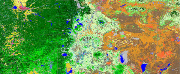
LANDFIRE- Landscape Fire and Resource Management Planning Tools
LANDFIRE- Landscape Fire and Resource Management Planning ToolsLANDFIRE Existing Vegetation Type imagery.
LANDFIRE- Landscape Fire and Resource Management Planning Tools
LANDFIRE- Landscape Fire and Resource Management Planning ToolsLANDFIRE Existing Vegetation Type imagery.

Landsat-8 nighttime thermal infrared image from April 2017 showing the Tern Lake
Landsat-8 nighttime thermal infrared image from April 2017 showing the Tern LakeLandsat-8 nighttime thermal infrared image from April 2017 showing the Tern Lake area. In Yellowstone, temperatures are extremely cold at night in the winter, and most lakes are frozen (dark pixels). West Tern Lake seems to be thawing here - perhaps it receives some thermal waters from nearby hot springs.

LSPIV camera setup over USGS gage 09333500 Dirty Devil River, UT
LSPIV camera setup over USGS gage 09333500 Dirty Devil River, UTLSPIV camera setup over USGS gage 09333500 Dirty Devil River above Poison Springs Wash nr Hanksville, UT.

Prescription medication
Hormones and pharmaceuticals, widely used for treatment of humans, domestic animals, and livestock, have the potential to enter the environment, including groundwater. In 2009, nearly 70% of Americans took at least one prescription drug, and more than half took 2 or more.
Hormones and pharmaceuticals, widely used for treatment of humans, domestic animals, and livestock, have the potential to enter the environment, including groundwater. In 2009, nearly 70% of Americans took at least one prescription drug, and more than half took 2 or more.

School Branch at Maloney Road near Brownsburg IN - dry stream
School Branch at Maloney Road near Brownsburg IN - dry streamSchool Branch at Maloney Road near Brownsburg IN - dry stream
School Branch at Maloney Road near Brownsburg IN - dry stream
School Branch at Maloney Road near Brownsburg IN - dry streamSchool Branch at Maloney Road near Brownsburg IN - dry stream